

Teban54 wrote:In other words, if a wave gets into Western Caribbean like the 0z Euro and 6z GFS show... Watch out.
Could be a Mitch redux?
Moderator: S2k Moderators

Teban54 wrote:In other words, if a wave gets into Western Caribbean like the 0z Euro and 6z GFS show... Watch out.


Ubuntwo wrote:galaxy401 wrote:The Caribbean has been dead due to how active the EPAC has been consistently. The storms over there pushes all the wind shear over the Caribbean.
This feels right, but shear over the Caribbean has been below average almost all season. Part of the issue seems to be a lack of tropical waves. Andy Hazleton has talked about this a few times. The waves either develop too early, are pulled north, or get desiccated by SAL before arriving. It’s just that the very few solid waves to track through the Caribbean have lined up with shear from the EPAC or dry conditions. So ‘bad luck’ (good luck?) has played a part.
zzzh wrote:From Michael Lowry:Interestingly, wind shear in the Caribbean has been running historically low through the heart of the season – consistent with a budding La Niña in the eastern equatorial Pacific. Since September, wind shear across the Caribbean has been the third lowest since 1979.
https://i.imgur.com/tPz1pmi.png
chaser1 wrote:Teban54 wrote:In other words, if a wave gets into Western Caribbean like the 0z Euro and 6z GFS show... Watch out.
Could be a Mitch redux?


Category5Kaiju wrote:To say that I'm concerned about the future of this season is....an understatement.
With Erin already reaching Category 5 status by mid-August and with rumblings of yet another storm originating in the deep tropics in the coming days/weeks that potentially looks to be more of a land threat than Erin, there's no telling what September and October are going to look like. The fact that we're getting such formidable activity in what recently has been a relatively dead period in the Atlantic, combined with the expected -ENSO trend, makes me think that we still have a lot of season left and that Erin may not be the only Category 5 hurricane we see this season.
I know there's been a lot of mixed signals early on this hurricane season, but at this point I think the tropics have really shown how they would like to proceed forward in terms of activity. Buckle up, and be prepared.


Category5Kaiju wrote:Category5Kaiju wrote:To say that I'm concerned about the future of this season is....an understatement.
With Erin already reaching Category 5 status by mid-August and with rumblings of yet another storm originating in the deep tropics in the coming days/weeks that potentially looks to be more of a land threat than Erin, there's no telling what September and October are going to look like. The fact that we're getting such formidable activity in what recently has been a relatively dead period in the Atlantic, combined with the expected -ENSO trend, makes me think that we still have a lot of season left and that Erin may not be the only Category 5 hurricane we see this season.
I know there's been a lot of mixed signals early on this hurricane season, but at this point I think the tropics have really shown how they would like to proceed forward in terms of activity. Buckle up, and be prepared.
Wow....I really said that.
MEANINGLESS_NUMBERS wrote:So what do we think? Done for the year? On average, November has 1 named storm. No likely candidates in the short term though.
MEANINGLESS_NUMBERS wrote:So what do we think? Done for the year? On average, November has 1 named storm. No likely candidates in the short term though.


MEANINGLESS_NUMBERS wrote:So what do we think? Done for the year? On average, November has 1 named storm. No likely candidates in the short term though.

Category5Kaiju wrote:https://www.star.nesdis.noaa.gov/pub/socd/mecb/crw/data/5km/v3.1_op/image_browse/daily/ssta/png/2025/ct5km_ssta_v3.1_global_20251101.png
Did you know that there was a high-end, extremely slow-moving Category 5 hurricane in the Western Caribbean Sea just a little less than a week ago?
Rhetorical question, of course.

Team Ghost wrote:Despite the near-record breaking number of Category V storms this season produced (Erin, Humberto, and Melissa), is it surprising, at least to me, that this season only produced 13 storms, only 5 of which became hurricanes. Perhaps someone more knowledgeable than me can explain why there are relatively so few storms and hurricanes; but either I would have expected a season with 3 Category V hurricanes to rival 2005 or 2020 in activity, or I would have expected a season with 13 storms and 5 hurricanes to have at most 1 Category V. Is there any precedent to this?

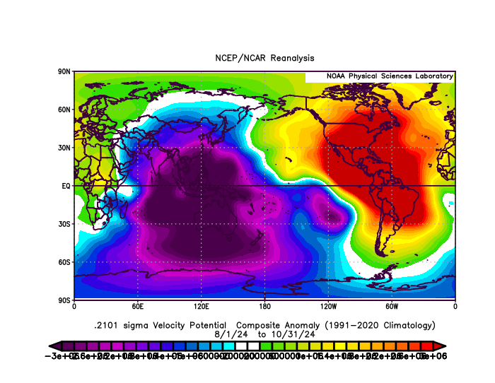
zzzh wrote:African standing wave from June to Sep was the most suppressive in this AMO+ period (since 1995). The level of sinking air in Africa-tropical Atlantic is comparable to some of the most inactive seasons in -AMO period.
WeatherBoy2000 wrote:zzzh wrote:African standing wave from June to Sep was the most suppressive in this AMO+ period (since 1995). The level of sinking air in Africa-tropical Atlantic is comparable to some of the most inactive seasons in -AMO period.
It'll be interesting to see if this year was just a one-off fluke or the start of a more suppressive period for the Atlantic. Ignoring majors/ace, this season only produced five hurricanes and 13 storms, the lowest since 2015.
zzzh wrote:African standing wave from June to Sep was the most suppressive in this AMO+ period (since 1995). The level of sinking air in Africa-tropical Atlantic is comparable to some of the most inactive seasons in -AMO period.
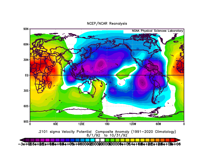
Team Ghost wrote:zzzh wrote:African standing wave from June to Sep was the most suppressive in this AMO+ period (since 1995). The level of sinking air in Africa-tropical Atlantic is comparable to some of the most inactive seasons in -AMO period.
Judging by eye, the last time the African Standing Wave looked this suppressed was 1992.
https://i.postimg.cc/bwncFSd9/IMG-1147.gif
Users browsing this forum: Google [Bot] and 134 guests
