NATL: MELISSA - Models

Moderator: S2k Moderators

Message
Author
xironman
S2K Supporter
S2K Supporter
Posts: 2535
Joined: Sun Jun 10, 2007 4:53 pm
Location: NoVA

Re: NATL: MELISSA - Models

#281 Postby xironman » Wed Oct 22, 2025 3:00 pm

SouthFLTropics wrote:That is not Melissa on the GFS


At this distance the models can break things apart but still end up at the right solution
0 likes   

User avatar
KirbyDude25
Tropical Storm
Tropical Storm
Posts: 161
Age: 20
Joined: Mon Sep 20, 2021 8:03 am
Location: Westfield, New Jersey

Re: NATL: MELISSA - Models

#282 Postby KirbyDude25 » Wed Oct 22, 2025 3:10 pm

MEANINGLESS_NUMBERS wrote:Absolutely nutso run from HAFS-B; 884 mbar, 173.4 knots at 126 hours and it looks like higher at 132 (which I don't have access to):

https://i.imgur.com/sIAb01V.png

Amazingly, the experimental v2.2.1-B version of the model is even more absurd, with a peak of 873 mb and 186 knots. Again, definitely overcooked, but the western Caribbean (especially Jamaica and Cuba) should be keeping a very close eye on this storm
3 likes   
New Jersey, Rutgers '27
Irene 2011 | Sandy 2012 | Fay 2020 | Isaias 2020 | Ida 2021

CrazyC83
Professional-Met
Professional-Met
Posts: 34306
Joined: Tue Mar 07, 2006 11:57 pm
Location: Deep South, for the first time!

Re: NATL: MELISSA - Models

#283 Postby CrazyC83 » Wed Oct 22, 2025 3:12 pm

KirbyDude25 wrote:
MEANINGLESS_NUMBERS wrote:Absolutely nutso run from HAFS-B; 884 mbar, 173.4 knots at 126 hours and it looks like higher at 132 (which I don't have access to):

https://i.imgur.com/sIAb01V.png

Amazingly, the experimental v2.2.1-B version of the model is even more absurd, with a peak of 873 mb and 186 knots. Again, definitely overcooked, but the western Caribbean (especially Jamaica and Cuba) should be keeping a very close eye on this storm


It was 10 years ago this week that Patricia happened. Let's not count the chickens before they hatch. Not saying it will happen, or that even being the most likely, but nothing can be ruled out.
3 likes   

User avatar
Spacecoast
Category 2
Category 2
Posts: 773
Joined: Thu Aug 31, 2017 2:03 pm

Re: NATL: MELISSA - Models

#284 Postby Spacecoast » Wed Oct 22, 2025 3:22 pm

A few ensemble members from GenCast / FNV3 approach, or cross SFL. Maybe 5 members out of 360 (only 1.5%).

Image
0 likes   

User avatar
Iceresistance
Category 5
Category 5
Posts: 9413
Age: 22
Joined: Sat Oct 10, 2020 9:45 am
Location: Tecumseh, OK/Norman, OK

Re: NATL: MELISSA - Models

#285 Postby Iceresistance » Wed Oct 22, 2025 3:31 pm

KirbyDude25 wrote:
MEANINGLESS_NUMBERS wrote:Absolutely nutso run from HAFS-B; 884 mbar, 173.4 knots at 126 hours and it looks like higher at 132 (which I don't have access to):

https://i.imgur.com/sIAb01V.png

Amazingly, the experimental v2.2.1-B version of the model is even more absurd, with a peak of 873 mb and 186 knots. Again, definitely overcooked, but the western Caribbean (especially Jamaica and Cuba) should be keeping a very close eye on this storm
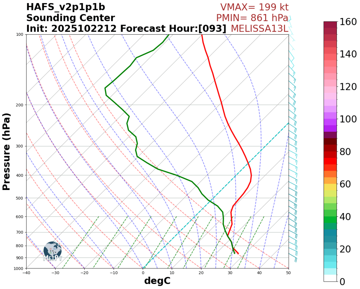
Someone managed to get this one, and it shows 199 knots and 861 mb, absolutely insane
Image
https://s12.gifyu.com/images/b3vfk.png
The image is after the data got plotted on Python
10 likes   
Bill 2015 & Beta 2020

Winter 2020-2021 :cold:

All observations are in Tecumseh, OK unless otherwise noted.

Winter posts are focused mainly for Oklahoma & Texas.

Take any of my forecasts with a grain of salt, refer to the NWS, SPC, and NHC for official information

Never say Never with weather! Because ANYTHING is possible!

User avatar
Travorum
Category 2
Category 2
Posts: 623
Joined: Tue Sep 05, 2023 9:36 am
Location: Dunedin, FL

Re: NATL: MELISSA - Models

#286 Postby Travorum » Wed Oct 22, 2025 3:38 pm

Here's the 12z experimental HAFSV2.1.1B, which went absolutely insane, the peak winds were in the sounding above at 199kts but the frame after the pressure dropped more to 859mb. I'm not sure what all's different from the operational or how well it has verified in the past (obviously it seems quite overcooked here) but it's been extremely bullish on Melissa for days.

Image
7 likes   

MarioProtVI
Category 5
Category 5
Posts: 1032
Age: 24
Joined: Sun Sep 29, 2019 7:33 pm
Location: New Jersey

Re: NATL: MELISSA - Models

#287 Postby MarioProtVI » Wed Oct 22, 2025 3:58 pm

CrazyC83 wrote:
MarioProtVI wrote:
Tekken_Guy wrote:
Melissa is not a threat to the northeast. Most evidence points to it going out to sea after the Cuba hit.

They said that when Sandy first formed. Then look what happened.

Also 12z CMC just hates me to the fact that’s literally on Halloween and under a week before the gubernatorial election here in NJ, just like how Sandy was in 2012 with the presidential election. The fact some 12z EURO AIFS members start bending it back west towards the U.S. is not helping.


If anything, the atmosphere next week looks even more chaotic than in 2012. You're going to have not one, but at least two opportunities to draw it in as it looks like at least two troughs will come through. The big question is whether a ridge can build in between the two as the first trough lifts - that would be the difference. Or if this can outrace the first trough (less likely).

Amazing :roll: :lol:
1 likes   

User avatar
Teban54
Category 5
Category 5
Posts: 3785
Joined: Sat May 19, 2018 1:19 pm

Re: NATL: MELISSA - Models

#288 Postby Teban54 » Wed Oct 22, 2025 4:06 pm

As a throwback, I found some HAFS-B runs for Milton in its model thread and the Crazy Model Runs thread, and compared them to its actual intensity.

I focused on HAFS-B solely for simplicity and considering that it's the most aggressive model for Melissa now. Note that in some of these 2024 runs, HAFS-A actually showed a stronger Milton. Also, not all runs are available (especially because the models thread was focused on landfalls at the time rather than peak intensity).

Note that these lead times are short (<48 hrs), as I didn't look through earlier runs beyond the first mention in Crazy Model Runs (and Milton's potential to even form at all wasn't apparent until a handful days prior). Their generalizability to 126-hr HAFS-B runs may thus be in question.

For reference, here are the HAFS-B Melissa runs, with a much longer lead time:

  • HAFS-B, 00z 10/22/25: 889 mb / 164 kt
  • HAFS-B, 06z 10/22/25: 900 mb / 144 kt
  • HAFS-B, 12z 10/22/25: 884 mb / 173 kt
6 likes   

User avatar
Hypercane_Kyle
Category 5
Category 5
Posts: 3465
Joined: Sat Mar 07, 2015 7:58 pm
Location: Cape Canaveral, FL

Re: NATL: MELISSA - Models

#289 Postby Hypercane_Kyle » Wed Oct 22, 2025 4:23 pm

Pretty clear at this point the GFS is in lalaland. Not even really worth looking at.
3 likes   
My posts are my own personal opinion, defer to the National Hurricane Center (NHC) and other NOAA products for decision making during hurricane season.

User avatar
Iceresistance
Category 5
Category 5
Posts: 9413
Age: 22
Joined: Sat Oct 10, 2020 9:45 am
Location: Tecumseh, OK/Norman, OK

Re: NATL: MELISSA - Models

#290 Postby Iceresistance » Wed Oct 22, 2025 4:31 pm

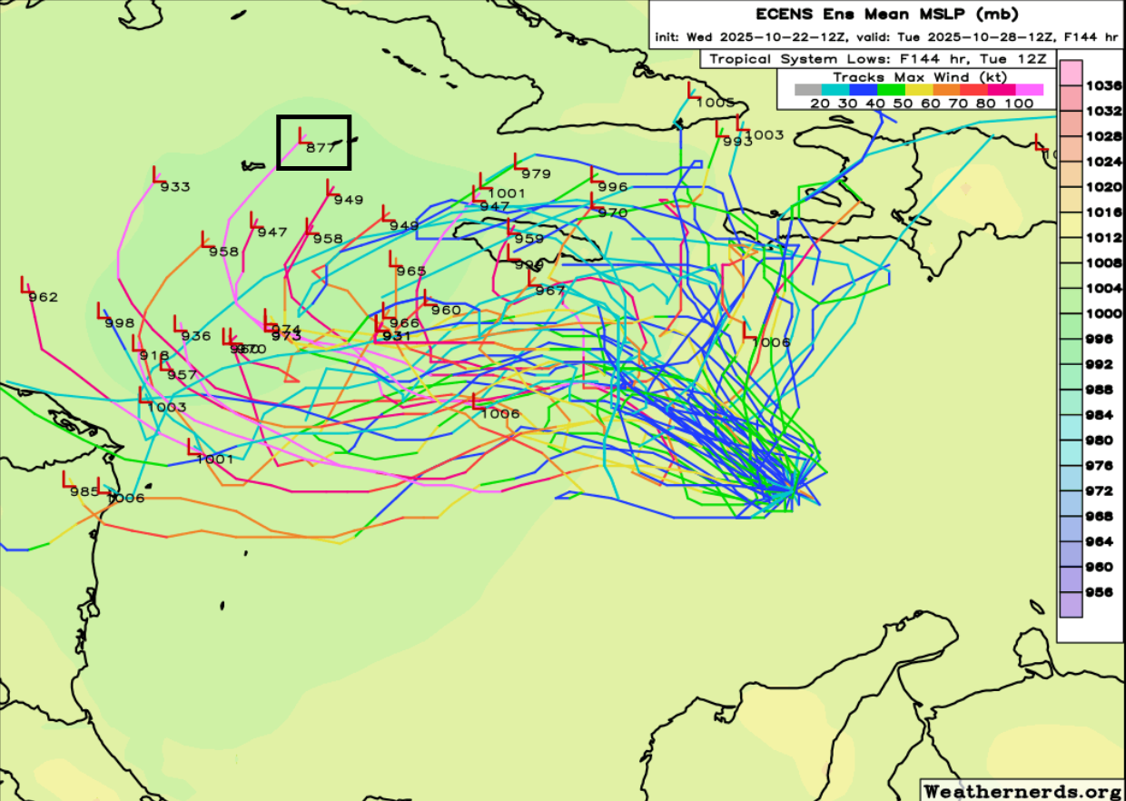
You are seeing this correctly, the EPS has a member that goes to 877 mb, I don't remember the last time the EPS had something like this before
Image
https://s12.gifyu.com/images/b3vrY.png
6 likes   
Bill 2015 & Beta 2020

Winter 2020-2021 :cold:

All observations are in Tecumseh, OK unless otherwise noted.

Winter posts are focused mainly for Oklahoma & Texas.

Take any of my forecasts with a grain of salt, refer to the NWS, SPC, and NHC for official information

Never say Never with weather! Because ANYTHING is possible!

User avatar
ronjon
Category 5
Category 5
Posts: 4890
Joined: Fri Aug 19, 2005 5:17 pm
Location: Hernando Beach, FL

Re: NATL: MELISSA - Models

#291 Postby ronjon » Wed Oct 22, 2025 4:33 pm

Spacecoast wrote:A few ensemble members from GenCast / FNV3 approach, or cross SFL. Maybe 5 members out of 360 (only 1.5%).

[url]https://i.ibb.co/M5k4XZHM/grd1.jpg [/url]


Yes unlikely at this time with these particular ensemble runs. However the trough and NE turn is 6 days away and things in the upper air pattern can still change - especially as we transition into a fall progressive long wave pattern. In the tropics, timing is everything. Where the storm is located, it's forward speed, it's intensity, timing of the trough, does the trough slow down and dig deeper, does a deeper storm pump up any ridging - just a few of many variables still unresolved at this point. Case in point - just look at the difference in GFS and Euro in the next 24-48 hrs.
2 likes   

User avatar
SFLcane
S2K Supporter
S2K Supporter
Posts: 10281
Age: 48
Joined: Sat Jun 05, 2010 1:44 pm
Location: Lake Worth Florida

Re: NATL: MELISSA - Models

#292 Postby SFLcane » Wed Oct 22, 2025 4:41 pm

Hmmm…

Image

Image
4 likes   

User avatar
Soluna16
Tropical Low
Tropical Low
Posts: 36
Joined: Sun Sep 22, 2024 9:30 pm

Re: NATL: MELISSA - Models

#293 Postby Soluna16 » Wed Oct 22, 2025 4:58 pm

2 likes   
Hurricane Experience: Charley 2004, Frances 2004, Jeanne 2004, Matthew 2016, Irma 2017, Dorian 2019, Ian 2022, Nicole 2022, Helene 2024, Milton 2024

LarryWx
S2K Supporter
S2K Supporter
Posts: 6854
Joined: Sun Sep 07, 2003 2:04 pm
Location: GA

Re: NATL: MELISSA - Models

#294 Postby LarryWx » Wed Oct 22, 2025 5:12 pm

For the record: The last 2 12Z JMA runs (they go out to 192) have shifted greatly to the E after earlier being pretty close to the UKMET W solutions:

12Z 10/21: very slow throughout and end up just W of Jamaica after curling back to the NNE

12Z 10/22: curls back to the NE over Jamaica at 156 and then to E tip of Cuba followed by Turks/Caicos
0 likes   
Personal Forecast Disclaimer:
The posts in this forum are NOT official forecasts and should not be used as such. They are just the opinion of the poster and may or may not be backed by sound meteorological data. They are NOT endorsed by any professional institution or storm2k.org. For official information, please refer to the NHC and NWS products.

ChrisH-UK
Category 2
Category 2
Posts: 665
Joined: Sat May 29, 2021 8:22 am

Re: NATL: MELISSA - Models

#295 Postby ChrisH-UK » Wed Oct 22, 2025 5:12 pm

Google Cyclone ML has the intensity modelling with 9 been Tropical storm, 4 Cat 1, 5 Cat2, 7 Cat 3, 7 Cat 4 and 14 been Cat 5 with the highest Speed been 179 knots and 897mb. Now with the lack of tropical cyclone activity this year in the Caribbean there is so much energy in the waters I wouldn't be surprised if it went nuclear like some models are showing. Where ever she goes it's going to apocalyptic.

Google Weather Lab - Tropical Cyclone Model

Image
1 likes   

User avatar
aspen
Category 5
Category 5
Posts: 9041
Joined: Sat Oct 12, 2019 7:10 pm
Location: Connecticut, USA

Re: NATL: MELISSA - Models

#296 Postby aspen » Wed Oct 22, 2025 5:50 pm

GFS once again refuses to back down on its quick Hispaniola scenario.

The ICON stalls over Haiti after a Cat 2/3 landfall, which would be horrifically devastating if it occurred. Fortunately it probably won’t.
3 likes   
Irene '11 Sandy '12 Hermine '16 5/15/2018 Derecho Fay '20 Isaias '20 Elsa '21 Henri '21 Ida '21

I am only a meteorology enthusiast who knows a decent amount about tropical cyclones. Look to the professional mets, the NHC, or your local weather office for the best information.

User avatar
ScottNAtlanta
Category 5
Category 5
Posts: 2535
Joined: Sat May 25, 2013 3:11 pm
Location: Atlanta, GA

Re: NATL: MELISSA - Models

#297 Postby ScottNAtlanta » Wed Oct 22, 2025 6:23 pm

ChrisH-UK wrote:Google Cyclone ML has the intensity modelling with 9 been Tropical storm, 4 Cat 1, 5 Cat2, 7 Cat 3, 7 Cat 4 and 14 been Cat 5 with the highest Speed been 179 knots and 897mb. Now with the lack of tropical cyclone activity this year in the Caribbean there is so much energy in the waters I wouldn't be surprised if it went nuclear like some models are showing. Where ever she goes it's going to apocalyptic.

Google Weather Lab - Tropical Cyclone Model

[url]https://imagizer.imageshack.com/v2/800x600q70/924/Ork9sn.png [/url]

Might as well give a 3 year old some coloured crayons and a map to scribble on. Would look close to the same
2 likes   
The posts in this forum are NOT official forecast and should not be used as such. They are just the opinion of the poster and may or may not be backed by sound meteorological data. They are NOT endorsed by any professional institution or storm2k.org. For official information, please refer to the NHC and NWS products.

User avatar
chaser1
S2K Supporter
S2K Supporter
Posts: 5758
Age: 64
Joined: Sat Oct 15, 2005 5:59 pm
Location: Longwood, Fl

Re: NATL: MELISSA - Models

#298 Postby chaser1 » Wed Oct 22, 2025 6:36 pm

aspen wrote:GFS once again refuses to back down on its quick Hispaniola scenario.

The ICON stalls over Haiti after a Cat 2/3 landfall, which would be horrifically devastating if it occurred. Fortunately it probably won’t.


I'm guessing that Melissa still has nearly 2 days to impress the judges :lol: Still time to deepen and align its LLC & MLC. Maybe unlikely after what we've been seeing for the last day or so but also within the realm of possibility. All model suggest the New England trough to remain in place for nearly 2 more days. Short of that occuring though, we'll have ICON & GFS at the door with mud on their faces sometime Friday, asking to come out of the cold and join their friends on the Western Caribbean bandwagon. :A:
1 likes   
Andy D

(For official information, please refer to the NHC and NWS products.)

User avatar
SouthFLTropics
Category 5
Category 5
Posts: 4258
Age: 50
Joined: Thu Aug 14, 2003 8:04 am
Location: Port St. Lucie, Florida

Re: NATL: MELISSA - Models

#299 Postby SouthFLTropics » Wed Oct 22, 2025 6:37 pm

18z HAFS-B has so far backed off significantly from the earlier insane 12z run.
1 likes   
Fourth Generation Florida Native

Personal Storm History: David 79, Andrew 92, Erin 95, Floyd 99, Irene 99, Frances 04, Jeanne 04, Wilma 05, Matthew 16, Irma 17, Ian 22, Nicole 22, Milton 24

LarryWx
S2K Supporter
S2K Supporter
Posts: 6854
Joined: Sun Sep 07, 2003 2:04 pm
Location: GA

Re: NATL: MELISSA - Models

#300 Postby LarryWx » Wed Oct 22, 2025 6:39 pm

18Z Euro gives much of Jamaica near or just over 20” qpf with heavy rain still likely continuing for a few more hours with the storm then still centered over SW Jamaica; SLP is then way down at 943 mb with it moving slowly NNE while SSE of a strong upper trough that’s then over the E US.
0 likes   
Personal Forecast Disclaimer:
The posts in this forum are NOT official forecasts and should not be used as such. They are just the opinion of the poster and may or may not be backed by sound meteorological data. They are NOT endorsed by any professional institution or storm2k.org. For official information, please refer to the NHC and NWS products.


Return to “2025”

Who is online

Users browsing this forum: No registered users and 29 guests