NATL: MELISSA - Models
Moderator: S2k Moderators

Re: NATL: MELISSA - Models
chaser1 wrote:BobHarlem wrote:12z Euro ravages Jamaica then has a cat 4/5 landfall on Guantanamo Bay
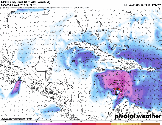
https://i.postimg.cc/FKjLPctw/floop-ecmwf-full-2025102212-sfcwind-mslp-caribbean.gif
After this it manages to slip in the gap between Nova Scotia and newfoundland and hit in upper Quebec.
INTERESTING! Looking closely, the EURO begins to make Melissa's northeast turn right around 144 hrs. CMC does the same at the same time frame, albeit from a further west longitude. I havnt looked yet to see the other model (GFS excluded) forecast point where they too show the storm making her northward or NE turn. The mid-term steering picture may finally becoming a bit more clear once we get past today & tomorrow.
GFS has the storm drifting north basically from the start (certainly no later than this time tomorrow) and then accelerating to the northeast around hour 120 - so it both starts that acceleration much further east and also a day earlier. ICON does a northward drift like the GFS, but somewhat further west (over Jaimica instead of western Hispanola) but also accerates to the NE at 144.
So it seems like all of the models agree that the storm will accelerate out to the northeast on Tuesday or Wednesday next week, its just what happens in between thats the difference.
0 likes

Re: NATL: MELISSA - Models
Interesting that HMON and HAFS models following CMC path although slower. I think we'll know the ultimate path a little better after a few days when we see Melissa's heading and forward speed the next 48-72 hrs.
2 likes
-
Tekken_Guy
- Tropical Storm

- Posts: 150
- Joined: Fri Sep 01, 2017 8:08 pm
Re: NATL: MELISSA - Models
Fancy1002 wrote:This is just my opinion based on the model runs over the last few days. If Melissa gets close enough to slightly hit or barely scrape by South Florida, a direct hit on the northeast is pretty much guaranteed.
Melissa is not a threat to the northeast. Most evidence points to it going out to sea after the Cuba hit.
0 likes
Re: NATL: MELISSA - Models
Tekken_Guy wrote:Fancy1002 wrote:This is just my opinion based on the model runs over the last few days. If Melissa gets close enough to slightly hit or barely scrape by South Florida, a direct hit on the northeast is pretty much guaranteed.
Melissa is not a threat to the northeast. Most evidence points to it going out to sea after the Cuba hit.
I’m basing my assumption on the CMC model and some of the euro ensembles.
0 likes
Re: NATL: MELISSA - Models
Tekken_Guy wrote:Fancy1002 wrote:This is just my opinion based on the model runs over the last few days. If Melissa gets close enough to slightly hit or barely scrape by South Florida, a direct hit on the northeast is pretty much guaranteed.
Melissa is not a threat to the northeast. Most evidence points to it going out to sea after the Cuba hit.
Not to mention, it’s too early to say that. It seems to be primarily dependent on how west the storm gets and how quickly it heads north.
1 likes
-
CrazyC83
- Professional-Met

- Posts: 34315
- Joined: Tue Mar 07, 2006 11:57 pm
- Location: Deep South, for the first time!
Re: NATL: MELISSA - Models
Tekken_Guy wrote:Fancy1002 wrote:This is just my opinion based on the model runs over the last few days. If Melissa gets close enough to slightly hit or barely scrape by South Florida, a direct hit on the northeast is pretty much guaranteed.
Melissa is not a threat to the northeast. Most evidence points to it going out to sea after the Cuba hit.
Too soon to say that. With all these troughs coming in, all it takes is for a ridge between them to steer it over.
5 likes
Re: NATL: MELISSA - Models
Tekken_Guy wrote:Fancy1002 wrote:This is just my opinion based on the model runs over the last few days. If Melissa gets close enough to slightly hit or barely scrape by South Florida, a direct hit on the northeast is pretty much guaranteed.
Melissa is not a threat to the northeast. Most evidence points to it going out to sea after the Cuba hit.
Certainly climatology and model concensus suggest that its likely to move pretty quickly out to sea after its gets out of the nortern caribbean. But thats still a week away, and there are some model suggestions of the storm interacting with a low in the eastern US and getting tugged back into the mainland as an extratropical storm (I dont think anywhere on the US mainland but far southern florida has to fear a direct hit as a fully tropical system - but a Sandy-esque situation for the northeast or eastern canada doesnt seem like it can be completely ruled out yet.)
4 likes
-
MarioProtVI
- Category 5

- Posts: 1034
- Age: 24
- Joined: Sun Sep 29, 2019 7:33 pm
- Location: New Jersey
Re: NATL: MELISSA - Models
Tekken_Guy wrote:Fancy1002 wrote:This is just my opinion based on the model runs over the last few days. If Melissa gets close enough to slightly hit or barely scrape by South Florida, a direct hit on the northeast is pretty much guaranteed.
Melissa is not a threat to the northeast. Most evidence points to it going out to sea after the Cuba hit.
They said that when Sandy first formed. Then look what happened.
Also 12z CMC just hates me to the fact that’s literally on Halloween and under a week before the gubernatorial election here in NJ, just like how Sandy was in 2012 with the presidential election. The fact some 12z EURO AIFS members start bending it back west towards the U.S. is not helping.
4 likes
-
Tekken_Guy
- Tropical Storm
- Posts: 150
- Joined: Fri Sep 01, 2017 8:08 pm
Re: NATL: MELISSA - Models
Fancy1002 wrote:Tekken_Guy wrote:Fancy1002 wrote:This is just my opinion based on the model runs over the last few days. If Melissa gets close enough to slightly hit or barely scrape by South Florida, a direct hit on the northeast is pretty much guaranteed.
Melissa is not a threat to the northeast. Most evidence points to it going out to sea after the Cuba hit.
I’m basing my assumption on the CMC model and some of the euro ensembles.
Those models are vast outliers at the moment. Only a small number of the euro ensembles have a NE hit and CMC isn’t backed up by any other major models right now.
0 likes
-
KirbyDude25

- Tropical Storm
- Posts: 161
- Age: 20
- Joined: Mon Sep 20, 2021 8:03 am
- Location: Westfield, New Jersey
Re: NATL: MELISSA - Models
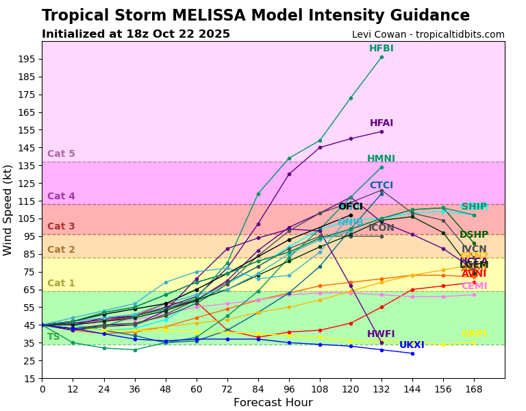
I don't have a picture on hand right now, but the 12Z FNV3 ensemble went bonkers again. 41/50 members have pressures under 950 mb, with 23/50 being under 920 mb. It has more members under 900 mb (5) than above 980 (4). The stronger members (most of the group) slowly move westward, then northwestward, then northward between Jamaica and CA, eventually landfalling on Cuba. The rest either landfall on Jamaica or thread the needle between Jamaica and Haiti, aside from a few that hit Haiti directly.
Edit: The NHC track seems to be in line with that west-of-Jamaica group I mentioned earlier (though it doesn't go far enough out yet to see the northward turn). This may suggest that they're internally favoring that group of solutions (and thus a stronger peak intensity), but it's also likely too early to tell.
Edit: The NHC track seems to be in line with that west-of-Jamaica group I mentioned earlier (though it doesn't go far enough out yet to see the northward turn). This may suggest that they're internally favoring that group of solutions (and thus a stronger peak intensity), but it's also likely too early to tell.
Last edited by KirbyDude25 on Wed Oct 22, 2025 2:34 pm, edited 1 time in total.
6 likes
New Jersey, Rutgers '27
Irene 2011 | Sandy 2012 | Fay 2020 | Isaias 2020 | Ida 2021
Irene 2011 | Sandy 2012 | Fay 2020 | Isaias 2020 | Ida 2021
-
AutoPenalti
- Category 5
- Posts: 4091
- Age: 29
- Joined: Mon Aug 17, 2015 4:16 pm
- Location: Ft. Lauderdale, Florida
Re: NATL: MELISSA - Models
We have to realize that we are forecasting a storm that is only moving a grand total of maybe 200-300 miles within 7 days... atmospheric conditions beyond that are hard to forecast.
3 likes
The posts in this forum are NOT official forecasts and should not be used as such. They are just the opinion of the poster and may or may not be backed by sound meteorological data. They are NOT endorsed by any professional institution or STORM2K. For official information, please refer to products from the NHC and NWS.
Model Runs Cheat Sheet:
GFS (5:30 AM/PM, 11:30 AM/PM)
HWRF, GFDL, UKMET, NAVGEM (6:30-8:00 AM/PM, 12:30-2:00 AM/PM)
ECMWF (1:45 AM/PM)
TCVN is a weighted averaged
-
SFLcane

- S2K Supporter

- Posts: 10281
- Age: 48
- Joined: Sat Jun 05, 2010 1:44 pm
- Location: Lake Worth Florida
Re: NATL: MELISSA - Models
AutoPenalti wrote:We have to realize that we are forecasting a storm that is only moving a grand total of maybe 200-300 miles within 7 days... atmospheric conditions beyond that are hard to forecast.
Anything is possible but climatological wise we are certainly outside now of that window unless something changes with a fall jetstream over the gulf and florida it will be VERY hard to get anything far north to were it affects southeast florida.
1 likes
-
Iceresistance

- Category 5
- Posts: 9579
- Age: 22
- Joined: Sat Oct 10, 2020 9:45 am
- Location: Tecumseh, OK/Norman, OK
Re: NATL: MELISSA - Models
I have no idea what the HAFS-B is even thinking, 195 knots is 225 mph. I don't think that is even possible right now, but good lord almighty
https://s12.gifyu.com/images/b3vZd.png
https://s12.gifyu.com/images/b3vZd.png
5 likes
Bill 2015 & Beta 2020
Winter 2020-2021
All observations are in Tecumseh, OK unless otherwise noted.
Winter posts are focused mainly for Oklahoma & Texas.
Take any of my forecasts with a grain of salt, refer to the NWS, SPC, and NHC for official information
Never say Never with weather! Because ANYTHING is possible!
Winter 2020-2021
All observations are in Tecumseh, OK unless otherwise noted.
Winter posts are focused mainly for Oklahoma & Texas.
Take any of my forecasts with a grain of salt, refer to the NWS, SPC, and NHC for official information
Never say Never with weather! Because ANYTHING is possible!
-
MEANINGLESS_NUMBERS
- Category 2

- Posts: 503
- Joined: Mon Nov 02, 2020 1:43 pm
Re: NATL: MELISSA - Models
Absolutely nutso run from HAFS-B; 884 mbar, 173.4 knots at 126 hours and it looks like higher at 132 (which I don't have access to):

1 likes
Emily '87, Felix '95, Gert '99, Fabian '03, Humberto '19, Paulette '20, Teddy '20, Fiona '22, Lee '23, Ernesto '24, Humberto/Imelda '25
-
Tekken_Guy
- Tropical Storm
- Posts: 150
- Joined: Fri Sep 01, 2017 8:08 pm
Re: NATL: MELISSA - Models
MarioProtVI wrote:Tekken_Guy wrote:Fancy1002 wrote:This is just my opinion based on the model runs over the last few days. If Melissa gets close enough to slightly hit or barely scrape by South Florida, a direct hit on the northeast is pretty much guaranteed.
Melissa is not a threat to the northeast. Most evidence points to it going out to sea after the Cuba hit.
They said that when Sandy first formed. Then look what happened.
Also 12z CMC just hates me to the fact that’s literally on Halloween and under a week before the gubernatorial election here in NJ, just like how Sandy was in 2012 with the presidential election. The fact some 12z EURO AIFS members start bending it back west towards the U.S. is not helping.
Sandy was headed straight north after Cuba. Most models didn’t get it as far outward from CONUS as what were generally seeing with Melissa.
0 likes


-
SouthFLTropics

- Category 5
- Posts: 4258
- Age: 50
- Joined: Thu Aug 14, 2003 8:04 am
- Location: Port St. Lucie, Florida
Re: NATL: MELISSA - Models
That is not Melissa on the GFS
0 likes
Fourth Generation Florida Native
Personal Storm History: David 79, Andrew 92, Erin 95, Floyd 99, Irene 99, Frances 04, Jeanne 04, Wilma 05, Matthew 16, Irma 17, Ian 22, Nicole 22, Milton 24
Personal Storm History: David 79, Andrew 92, Erin 95, Floyd 99, Irene 99, Frances 04, Jeanne 04, Wilma 05, Matthew 16, Irma 17, Ian 22, Nicole 22, Milton 24
-
SFLcane
- S2K Supporter
- Posts: 10281
- Age: 48
- Joined: Sat Jun 05, 2010 1:44 pm
- Location: Lake Worth Florida
Re: NATL: MELISSA - Models
MEANINGLESS_NUMBERS wrote:Absolutely nutso run from HAFS-B; 884 mbar, 173.4 knots at 126 hours and it looks like higher at 132 (which I don't have access to):
https://i.imgur.com/sIAb01V.png
Likely overdone lol atleast we can hope.

1 likes
-
CrazyC83
- Professional-Met
- Posts: 34315
- Joined: Tue Mar 07, 2006 11:57 pm
- Location: Deep South, for the first time!
Re: NATL: MELISSA - Models
MarioProtVI wrote:Tekken_Guy wrote:Fancy1002 wrote:This is just my opinion based on the model runs over the last few days. If Melissa gets close enough to slightly hit or barely scrape by South Florida, a direct hit on the northeast is pretty much guaranteed.
Melissa is not a threat to the northeast. Most evidence points to it going out to sea after the Cuba hit.
They said that when Sandy first formed. Then look what happened.
Also 12z CMC just hates me to the fact that’s literally on Halloween and under a week before the gubernatorial election here in NJ, just like how Sandy was in 2012 with the presidential election. The fact some 12z EURO AIFS members start bending it back west towards the U.S. is not helping.
If anything, the atmosphere next week looks even more chaotic than in 2012. You're going to have not one, but at least two opportunities to draw it in as it looks like at least two troughs will come through. The big question is whether a ridge can build in between the two as the first trough lifts - that would be the difference. Or if this can outrace the first trough (less likely).
2 likes
Who is online
Users browsing this forum: No registered users and 85 guests