2025 Global Model Runs Discussion (Out thru day 16)
Moderator: S2k Moderators
Forum rules

The posts in this forum are NOT official forecasts and should not be used as such. They are just the opinion of the poster and may or may not be backed by sound meteorological data. They are NOT endorsed by any professional institution or STORM2K. For official information, please refer to products from the National Hurricane Center and National Weather Service.

Re: 2025 Global Model Runs Discussion (Out thru day 16)
I know it doesn’t go far enough to tell, but it looks like the icon is joining the party with leaning into a central or west Caribbean development. Let’s see if the cmc follows suit.
Last edited by Fancy1002 on Mon Oct 13, 2025 10:47 am, edited 1 time in total.
1 likes
-
cycloneye

- Admin

- Posts: 149670
- Age: 69
- Joined: Thu Oct 10, 2002 10:54 am
- Location: San Juan, Puerto Rico
Re: 2025 Global Model Runs Discussion (Out thru day 16)
A good 3 part thread to read.
https://x.com/yconsor/status/1977747426736754770
https://x.com/yconsor/status/1977748146651283802
https://x.com/yconsor/status/1977748292185276874
https://x.com/yconsor/status/1977747426736754770
https://x.com/yconsor/status/1977748146651283802
https://x.com/yconsor/status/1977748292185276874
1 likes
Visit the Caribbean-Central America Weather Thread where you can find at first post web cams,radars
and observations from Caribbean basin members Click Here
and observations from Caribbean basin members Click Here
-
mrbagyo

- Category 5

- Posts: 3984
- Age: 33
- Joined: Thu Apr 12, 2012 9:18 am
- Location: 14.13N 120.98E
- Contact:
Re: 2025 Global Model Runs Discussion (Out thru day 16)
Could this be the one?
Last edited by mrbagyo on Tue Oct 28, 2025 9:12 am, edited 2 times in total.
4 likes
The posts in this forum are NOT official forecast and should not be used as such. They are just the opinion of the poster and may or may not be backed by sound meteorological data. They are NOT endorsed by any professional institution or storm2k.org. For official information, please refer to RSMC, NHC and NWS products.
Re: 2025 Global Model Runs Discussion (Out thru day 16)
Some AI ensemble members show development in the central/western Caribbean. Zero show development in the MDR.
1 likes

Re: 2025 Global Model Runs Discussion (Out thru day 16)
LarryWx wrote:LarryWx wrote:Jr0d wrote:Still a good ensemble signal in the west Carib from the GFS and Canadian at the end of their runs. However the GFS and to a lesser extent the Canadian has consistently shown a signal there often all season long so I dont think its anything to worry about for now.
The wave the models show possibly developing and heading towards PR is something we may need to keep an eye on...interesting enough the ICON has been the southern outlier...it will be interesting to see what it does when its forecast range takes it it PR's longitude.
Along with Happy Hour Icon, the Happy Hour GFS, like the 12Z, 0Z, and 5 runs before, has this. It hits Virgin Islands with a cat 1 H 10/22-3.
Edit: I just looked at 12Z UKMET maps. Although the text already told me there was no TC from this, the H5 vorticity and precip maps are closer to a TCG than prior runs. If this trend continues, the often genesis shy UKMET may have an actual TCG from this within the next run or two.
Sure enough, the 0Z UKMET has this as a TD going just N of due W at a rather brisk pace through the middle of the Lesser Antilles on Sunday (10/19): keep in mind that this is a top tier model that is sometimes genesis shyNEW TROPICAL CYCLONE FORECAST TO DEVELOP AFTER 150 HOURS
FORECAST POSITION AT T+150 : 13.5N 57.7W
LEAD CENTRAL MAXIMUM WIND
VERIFYING TIME TIME POSITION PRESSURE (MB) SPEED (KNOTS)
-------------- ---- -------- ------------- -------------
1200UTC 19.10.2025 156 13.8N 59.5W 1010 32
0000UTC 20.10.2025 168 14.1N 62.8W 1009 34
Also, the Icon (0Z) has it yet again.
Consistent with the 0Z, the 12Z UKMET has the followup MDR system moving WNW through the central Lesser Antilles on 10/19 and then into the far E Caribbean:
NEW TROPICAL CYCLONE FORECAST TO DEVELOP AFTER 138 HOURS
FORECAST POSITION AT T+138 : 13.9N 57.2W
LEAD CENTRAL MAXIMUM WIND
VERIFYING TIME TIME POSITION PRESSURE (MB) SPEED (KNOTS)
-------------- ---- -------- ------------- -------------
1200UTC 19.10.2025 144 14.2N 59.0W 1010 33
0000UTC 20.10.2025 156 14.6N 61.9W 1010 34
1200UTC 20.10.2025 168 15.1N 64.9W 1009 35
0 likes
Personal Forecast Disclaimer:
The posts in this forum are NOT official forecasts and should not be used as such. They are just the opinion of the poster and may or may not be backed by sound meteorological data. They are NOT endorsed by any professional institution or storm2k.org. For official information, please refer to the NHC and NWS products.
The posts in this forum are NOT official forecasts and should not be used as such. They are just the opinion of the poster and may or may not be backed by sound meteorological data. They are NOT endorsed by any professional institution or storm2k.org. For official information, please refer to the NHC and NWS products.
Re: 2025 Global Model Runs Discussion (Out thru day 16)
Am I seeing it wrong, or does it look like Lorenzo hanging around on the GFS, is splitting the Bermuda high from the east coast high enough to give future Melissa a path to head north in the central Caribbean rather than being pushed into the western Caribbean. Any more west and Miami might be in trouble.
Last edited by Fancy1002 on Mon Oct 13, 2025 12:06 pm, edited 1 time in total.
0 likes
Re: 2025 Global Model Runs Discussion (Out thru day 16)
It seems the cmc is just determined to stick with this odd timing scenario.
0 likes
Re: 2025 Global Model Runs Discussion (Out thru day 16)
Fancy1002 wrote:Am I seeing it wrong, or does it look like Lorenzo hanging around on the GFS, is splitting the Bermuda high from the east coast high enough to give future Melissa a path to head north in the central Caribbean rather than being pushed into the western Caribbean.
Lorenzo is tiny, it doesn't have significant impact on steering. The main reason is the east coast trough that pulls it north
1 likes
Re: 2025 Global Model Runs Discussion (Out thru day 16)
This GFS run is looking a bit ominous so far.
0 likes
Re: 2025 Global Model Runs Discussion (Out thru day 16)
zzzh wrote:Fancy1002 wrote:Am I seeing it wrong, or does it look like Lorenzo hanging around on the GFS, is splitting the Bermuda high from the east coast high enough to give future Melissa a path to head north in the central Caribbean rather than being pushed into the western Caribbean.
Lorenzo is tiny, it doesn't have significant impact on steering. The main reason is the east coast trough that pulls it north
To my knowledge, it’s not about the size of the storm, it’s about a low pressure system interrupting the connection between two high-pressure systems.
1 likes
Re: 2025 Global Model Runs Discussion (Out thru day 16)
Looks like a strong four or a weak five ramming into west Central Cuba, also a good amount west of the 06 run. Let’s see if that’s a continuing trend later today.
0 likes
Re: 2025 Global Model Runs Discussion (Out thru day 16)
If anyone has access to it, could you post IR picture at the 324 hour mark
0 likes
-
SouthFLTropics

- Category 5
- Posts: 4258
- Age: 50
- Joined: Thu Aug 14, 2003 8:04 am
- Location: Port St. Lucie, Florida
Re: 2025 Global Model Runs Discussion (Out thru day 16)
Today's 18z Happy Hour GFS may possibly be one of the most anticipated of the year so far based on the last two runs. You know the board will light up when it shows a major strike on South Florida, even if it is two weeks into fantasyland.
2 likes
Fourth Generation Florida Native
Personal Storm History: David 79, Andrew 92, Erin 95, Floyd 99, Irene 99, Frances 04, Jeanne 04, Wilma 05, Matthew 16, Irma 17, Ian 22, Nicole 22, Milton 24
Personal Storm History: David 79, Andrew 92, Erin 95, Floyd 99, Irene 99, Frances 04, Jeanne 04, Wilma 05, Matthew 16, Irma 17, Ian 22, Nicole 22, Milton 24

Re: 2025 Global Model Runs Discussion (Out thru day 16)
SouthFLTropics wrote:Today's 18z Happy Hour GFS may possibly be one of the most anticipated of the year so far based on the last two runs. You know the board will light up when it shows a major strike on South Florida, even if it is two weeks into fantasyland.
I think we had one or possibly two fantasy mode cane strikes this year far below the normal model cane strikes from last years.
0 likes
Re: 2025 Global Model Runs Discussion (Out thru day 16)
12z Euro drops it on this run...doesnt even start to develop into a tropical entity until its right on the coast with Nicaragua and then sends it to the Pacific where it starts developing.
12 CMC sends a hurricane north of the islands and out to sea like every storm this year
12 CMC sends a hurricane north of the islands and out to sea like every storm this year
1 likes
Re: 2025 Global Model Runs Discussion (Out thru day 16)
Half of the GFS ensemble members develop near or before the lesser Islands and head north, while the others don’t develop until they get to the Western Caribbean and then explode heading in a bunch of random directions
1 likes

Re: 2025 Global Model Runs Discussion (Out thru day 16)
Posting the 12z GFS run that people had mentioned above:
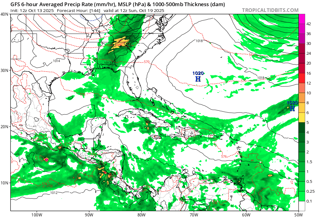
2 likes
TC naming lists: retirements and intensity
Most aggressive Advisory #1's in North Atlantic (cr. kevin for starting the list)
Most aggressive Advisory #1's in North Atlantic (cr. kevin for starting the list)
Re: 2025 Global Model Runs Discussion (Out thru day 16)
Regarding the MDR followup to Lorenzo:
1. I just noticed nobody mentioned the 12Z Icon, which had no more than a weak low at the Lesser Antilles, much weaker than prior runs.
Also, the Happy Hour Icon, though it goes out only to 120, is out far enough to know that it’s similarly weak to 12Z and much weaker than 0Z.
2. 12Z JMA: has pretty much nothing from this
————————
So, when also considering the weak Euro, there really is a lot of uncertainty when looking at the major 12Z operationals as a whole.
1 likes
Personal Forecast Disclaimer:
The posts in this forum are NOT official forecasts and should not be used as such. They are just the opinion of the poster and may or may not be backed by sound meteorological data. They are NOT endorsed by any professional institution or storm2k.org. For official information, please refer to the NHC and NWS products.
The posts in this forum are NOT official forecasts and should not be used as such. They are just the opinion of the poster and may or may not be backed by sound meteorological data. They are NOT endorsed by any professional institution or storm2k.org. For official information, please refer to the NHC and NWS products.
-
floridasun
- Tropical Storm

- Posts: 245
- Joined: Tue Sep 14, 2021 3:59 pm
Re: 2025 Global Model Runs Discussion (Out thru day 16)
i be looking at post here the way i look at too hype all models coming out this suppose system don't have yellow circle yet the way i take it let see how thing look by Friday by models runs and how look on sat pic
0 likes
-
Category5Kaiju

- Category 5
- Posts: 4345
- Joined: Thu Dec 24, 2020 12:45 pm
- Location: Seattle during the summer, Phoenix during the winter
Re: 2025 Global Model Runs Discussion (Out thru day 16)
Happy Hour GFS has your paradigm October WCAR monster; looks like this storm REALLY takes advantage of the untouched, 30 C Caribbean waters.
0 likes
Unless explicitly stated, all information in my posts is based on my own opinions and observations. Tropical storms and hurricanes can be extremely dangerous. Refer to an accredited weather research agency or meteorologist if you need to make serious decisions regarding an approaching storm.
Who is online
Users browsing this forum: gib, Google Adsense [Bot] and 161 guests