Surface Trough inland over Southern Mexico (0/0)

This is the general tropical discussion area. Anyone can take their shot at predicting a storms path.

Moderator: S2k Moderators

Forum rules

The posts in this forum are NOT official forecasts and should not be used as such. They are just the opinion of the poster and may or may not be backed by sound meteorological data. They are NOT endorsed by any professional institution or STORM2K. For official information, please refer to products from the National Hurricane Center and National Weather Service.

Help Support Storm2K
Message
Author
User avatar
Teban54
Category 5
Category 5
Posts: 3761
Joined: Sat May 19, 2018 1:19 pm

Surface Trough inland over Southern Mexico (0/0)

#1 Postby Teban54 » Mon Oct 06, 2025 7:56 pm

Been here since the previous TWO this afternoon (2pm EDT 10/6). Surprised nobody has mentioned it yet.

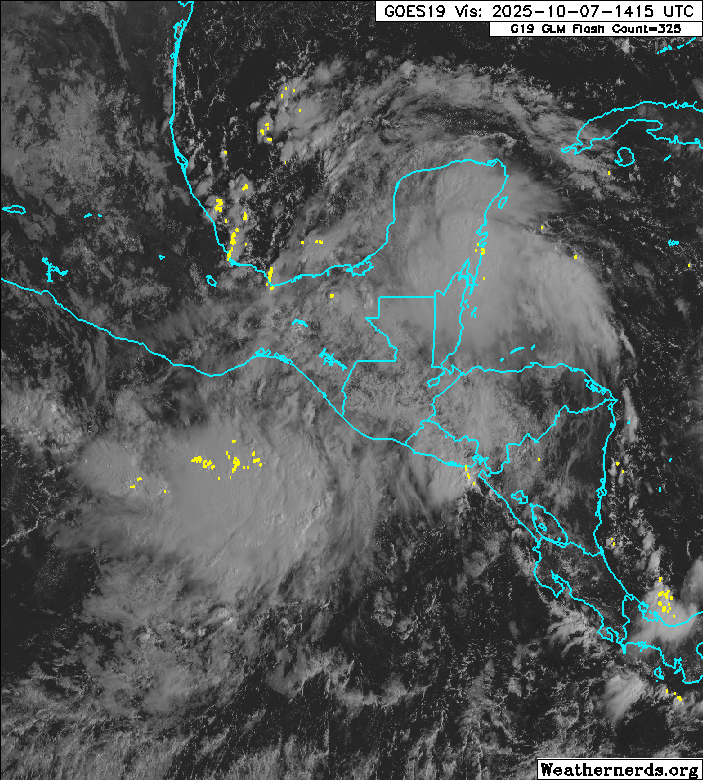
2. Yucatan Peninsula and Southwestern Gulf:
A trough of low pressure currently moving across the Yucatan
Peninsula is expected to emerge into the Bay of Campeche during the
day on Tuesday. The system is producing a large area of disorganized
showers and thunderstorms, and some slow development of this system
is possible over the Bay of Campeche before it moves inland by the
middle portion of this week. Regardless of development, areas of
heavy rain and gusty winds are likely across portions of the Yucatan
Peninsula, Belize, and southern Mexico during the next few days.
* Formation chance through 48 hours...low...10 percent.
* Formation chance through 7 days...low...10 percent
.


Image

Image
1 likes   

User avatar
Teban54
Category 5
Category 5
Posts: 3761
Joined: Sat May 19, 2018 1:19 pm

Re: Surface Trough moving into the Bay of Campeche (10/10)

#2 Postby Teban54 » Tue Oct 07, 2025 7:32 am

Some big convective blowup this morning, although detached from where the NHC has the "center".

Image
1 likes   

ChrisH-UK
Category 2
Category 2
Posts: 665
Joined: Sat May 29, 2021 8:22 am

Re: Surface Trough moving into the Bay of Campeche (10/10)

#3 Postby ChrisH-UK » Tue Oct 07, 2025 9:02 am

The large sprawling mass of this surface trough it should move over the Yucatan then into the Bay of Campeche, should be interesting on what happens there.

Image
1 likes   

User avatar
Teban54
Category 5
Category 5
Posts: 3761
Joined: Sat May 19, 2018 1:19 pm

Re: Surface Trough over the eastern Bay of Campeche (10/10)

#4 Postby Teban54 » Tue Oct 07, 2025 2:27 pm

Still alive both in the TWO and in real life. Needless to say, proximity with 90E is the biggest question mark.

1. Southwestern Gulf:
A trough of low pressure located over the Yucatan Peninsula is
producing a large area of disorganized showers and thunderstorms.
This system is expected to emerge over the Bay of Campeche later
today, and some slow development is possible before it moves inland
over southern Mexico late Wednesday or early Thursday. Regardless
of development, areas of heavy rain and gusty winds are likely
across portions of the Yucatan Peninsula, Belize, and southern
Mexico during the next couple of days.
* Formation chance through 48 hours...low...10 percent.
* Formation chance through 7 days...low...10 percent.


Image
1 likes   

User avatar
AJC3
Admin
Admin
Posts: 4144
Age: 61
Joined: Tue Aug 31, 2004 7:04 pm
Location: Ballston Spa, New York
Contact:

Re: Surface Trough over the eastern Bay of Campeche (10/10)

#5 Postby AJC3 » Tue Oct 07, 2025 3:43 pm

Teban54 wrote:Still alive both in the TWO and in real life. Needless to say, proximity with 90E is the biggest question mark.

1. Southwestern Gulf:
A trough of low pressure located over the Yucatan Peninsula is
producing a large area of disorganized showers and thunderstorms.
This system is expected to emerge over the Bay of Campeche later
today, and some slow development is possible before it moves inland
over southern Mexico late Wednesday or early Thursday. Regardless
of development, areas of heavy rain and gusty winds are likely
across portions of the Yucatan Peninsula, Belize, and southern
Mexico during the next couple of days.
* Formation chance through 48 hours...low...10 percent.
* Formation chance through 7 days...low...10 percent.


https://i.postimg.cc/NjGvK3h4/24197918.gif


They should get on the same page as WPC soon enough. As of 18Z, they analyzed the trough axis as having emerged over the eastern BOC.
1 likes   

User avatar
Teban54
Category 5
Category 5
Posts: 3761
Joined: Sat May 19, 2018 1:19 pm

Re: Surface Trough over the western Bay of Campeche (10/10)

#6 Postby Teban54 » Wed Oct 08, 2025 11:13 am

Still on the TWO this morning and producing convection, but about to go inland. Perhaps they're keeping the mention until then?

1. Southwestern Gulf:
Disorganized showers and thunderstorms continue with a trough of low
pressure moving westward across the Bay of Campeche. Some slow
development of this system is possible before it moves inland over
southern Mexico later today or early Thursday. Regardless of
development, areas of heavy rain and gusty winds are likely across
portions of southern Mexico during the next day or so.
* Formation chance through 48 hours...low...10 percent.
* Formation chance through 7 days...low...10 percent.


Image
1 likes   

User avatar
AJC3
Admin
Admin
Posts: 4144
Age: 61
Joined: Tue Aug 31, 2004 7:04 pm
Location: Ballston Spa, New York
Contact:

Re: Surface Trough over the western Bay of Campeche (10/10)

#7 Postby AJC3 » Wed Oct 08, 2025 6:43 pm

From early this afternoon (soon to be updated) ...

Tropical Weather Outlook
NWS National Hurricane Center Miami FL
200 PM EDT Wed Oct 8 2025

Bay of Campeche:
Disorganized showers and thunderstorms continue with a trough of low
pressure moving westward across the Bay of Campeche. The system is
expected to move inland over Mexico tonight, and therefore its
opportunity for any development will be ending soon. Regardless,
areas of heavy rain and gusty winds are likely across portions of
southern Mexico during the next day or so.
* Formation chance through 48 hours...low...10 percent.
* Formation chance through 7 days...low...10 percent.
0 likes   

User avatar
AJC3
Admin
Admin
Posts: 4144
Age: 61
Joined: Tue Aug 31, 2004 7:04 pm
Location: Ballston Spa, New York
Contact:

Re: Surface Trough over the western Bay of Campeche (10/10)

#8 Postby AJC3 » Wed Oct 08, 2025 7:40 pm

Aaaand here's the "update"...

Tropical Weather Outlook
NWS National Hurricane Center Miami FL
800 PM EDT Wed Oct 8 2025

Bay of Campeche:
Disorganized showers and thunderstorms continue with a trough of low
pressure moving across the Bay of Campeche, nearing the Mexican
coastline. The system is expected to move inland over Mexico
tonight, and its opportunity for any development will soon be
ending. Regardless, areas of heavy rain and gusty winds are likely
across portions of southern Mexico during the next day or so.
* Formation chance through 48 hours...low...10 percent.
* Formation chance through 7 days...low...10 percent.
0 likes   

User avatar
AJC3
Admin
Admin
Posts: 4144
Age: 61
Joined: Tue Aug 31, 2004 7:04 pm
Location: Ballston Spa, New York
Contact:

Re: Surface Trough inland over Southern Mexico (0/0)

#9 Postby AJC3 » Thu Oct 09, 2025 2:45 am

It was inevitable...

Tropical Weather Outlook
NWS National Hurricane Center Miami FL
200 AM EDT Thu Oct 9 2025

Bay of Campeche:
A trough of low pressure associated with some disorganized showers
and thunderstorms has moved inland over southern Mexico, and
development is not expected. Heavy rain and gusty winds will
continue across portions of southern Mexico today.
* Formation chance through 48 hours...low...near 0 percent.
* Formation chance through 7 days...low...near 0 percent.
0 likes   


Return to “Talkin' Tropics”

Who is online

Users browsing this forum: ncforecaster89 and 68 guests