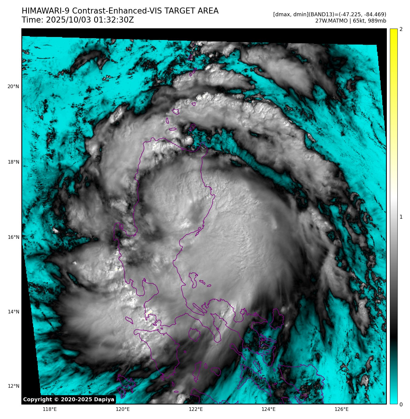
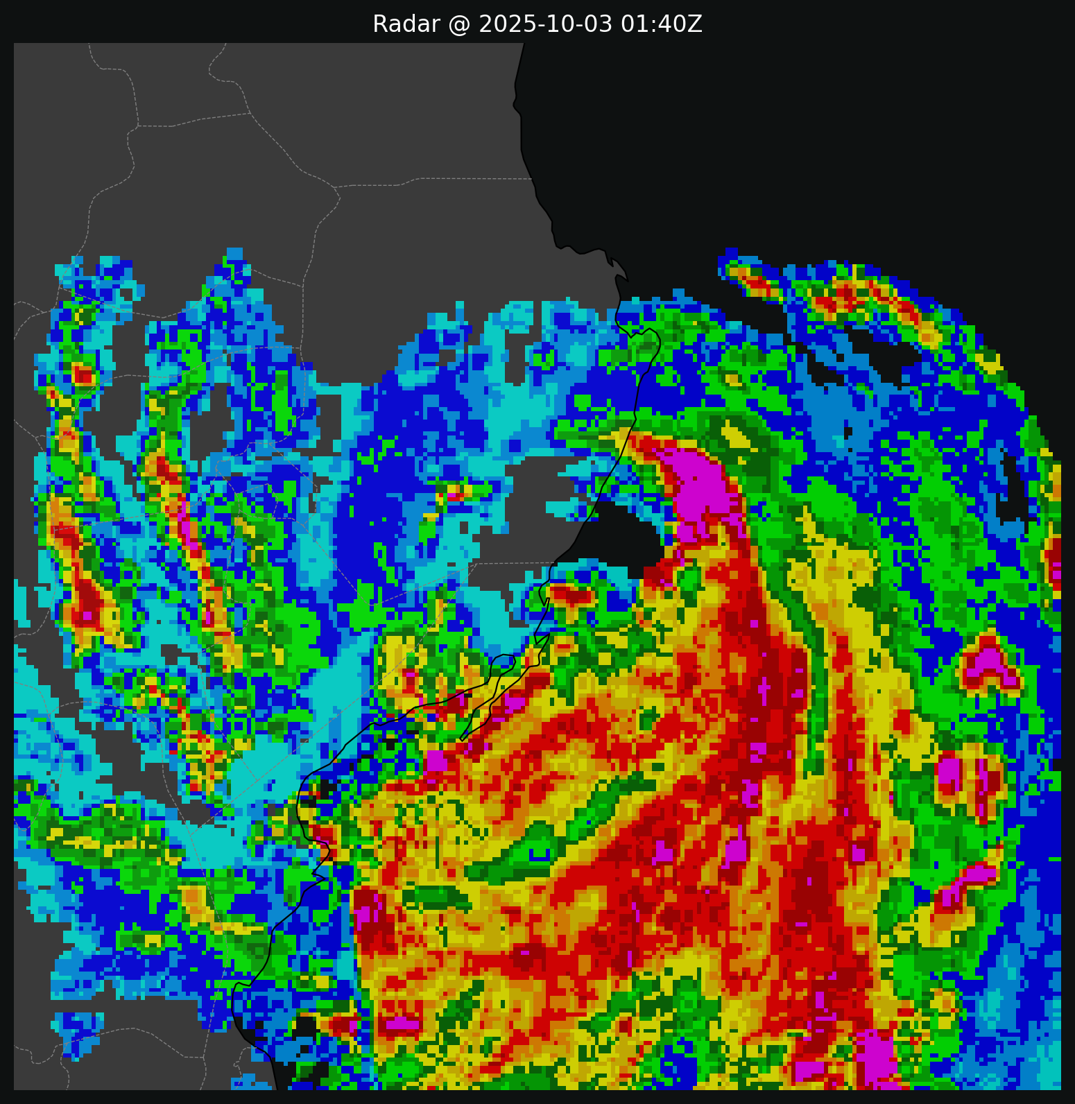
WPAC: MATMO - Post-Tropical
Moderator: S2k Moderators
- doomhaMwx
- Category 5

- Posts: 2486
- Age: 27
- Joined: Tue Apr 18, 2017 4:01 am
- Location: Baguio/Benguet, Philippines
- Contact:
Re: WPAC: MATMO - Severe Tropical Storm
JTWC 65KT / PAGASA 70KT. Currently making landfall near/over the Isabela-Aurora border.


0 likes
- cycloneye
- Admin

- Posts: 148541
- Age: 69
- Joined: Thu Oct 10, 2002 10:54 am
- Location: San Juan, Puerto Rico
Re: WPAC: MATMO - Severe Tropical Storm
0 likes
Visit the Caribbean-Central America Weather Thread where you can find at first post web cams,radars
and observations from Caribbean basin members Click Here
- mrbagyo
- Category 5

- Posts: 3962
- Age: 33
- Joined: Thu Apr 12, 2012 9:18 am
- Location: 14.13N 120.98E
- Contact:
Re: WPAC: MATMO - Severe Tropical Storm

0 likes
The posts in this forum are NOT official forecast and should not be used as such. They are just the opinion of the poster and may or may not be backed by sound meteorological data. They are NOT endorsed by any professional institution or storm2k.org. For official information, please refer to RSMC, NHC and NWS products.
Re: WPAC: MATMO - Severe Tropical Storm
Up to 80 kts on best track; officially stronger than it was at landfall in the Phillipines. Forecast to reach 90 kts (JTWC) or 75 kts (JMA) before its second landfall.
1 likes
-
Sciencerocks
- Category 5

- Posts: 10180
- Age: 39
- Joined: Thu Jul 06, 2017 1:51 am
Re: WPAC: MATMO - Typhoon
Typhoon
T2521(Matmo)
Issued at 2025/10/05 01:10 UTC
Analysis at 10/05 00 UTC
Grade TY
Scale -
Intensity -
Center position N20°20′ (20.3°)
E111°30′ (111.5°)
Direction and speed of movement WNW 20 km/h (12 kt)
Central pressure 975 hPa
Maximum sustained wind speed near center 35 m/s (65 kt)
Maximum wind gust speed 50 m/s (95 kt)
Radius of 50-kt wind area 75 km (40 NM)
Radius of 30-kt wind area E390 km (210 NM)
W280 km (150 NM)
0 likes
ヤンデレ女が寝取られるているのを見たい!!!
ECMWF ensemble NWPAC plots: https://ecmwfensnwpac.imgbb.com/
Multimodel NWPAC plots: https://multimodelnwpac.imgbb.com/
GFS Ensemble NWPAC plots (16 & 35 day forecast): https://gefsnwpac.imgbb.com/
Plots updated automatically
ECMWF ensemble NWPAC plots: https://ecmwfensnwpac.imgbb.com/
Multimodel NWPAC plots: https://multimodelnwpac.imgbb.com/
GFS Ensemble NWPAC plots (16 & 35 day forecast): https://gefsnwpac.imgbb.com/
Plots updated automatically
-
Sciencerocks
- Category 5

- Posts: 10180
- Age: 39
- Joined: Thu Jul 06, 2017 1:51 am
- mrbagyo
- Category 5

- Posts: 3962
- Age: 33
- Joined: Thu Apr 12, 2012 9:18 am
- Location: 14.13N 120.98E
- Contact:
Re: WPAC: MATMO - Typhoon


0 likes
The posts in this forum are NOT official forecast and should not be used as such. They are just the opinion of the poster and may or may not be backed by sound meteorological data. They are NOT endorsed by any professional institution or storm2k.org. For official information, please refer to RSMC, NHC and NWS products.
- mrbagyo
- Category 5

- Posts: 3962
- Age: 33
- Joined: Thu Apr 12, 2012 9:18 am
- Location: 14.13N 120.98E
- Contact:
Re: WPAC: MATMO - Typhoon
As of 12 PM local time (0400UTC)
Three Gorges Phase III Wind Power Platform Meteorological Observation Station
Coordinates: (Lat: 21.2740, Long:111.6040)
Elevation: 37 meters
The station has recorded a 10 minute sustained wind of 43.5 mps (156.6 kph) and a peak gust of 56 mps (201.6 kph)
Three Gorges Phase III Wind Power Platform Meteorological Observation Station
Coordinates: (Lat: 21.2740, Long:111.6040)
Elevation: 37 meters
The station has recorded a 10 minute sustained wind of 43.5 mps (156.6 kph) and a peak gust of 56 mps (201.6 kph)
0 likes
The posts in this forum are NOT official forecast and should not be used as such. They are just the opinion of the poster and may or may not be backed by sound meteorological data. They are NOT endorsed by any professional institution or storm2k.org. For official information, please refer to RSMC, NHC and NWS products.
- mrbagyo
- Category 5

- Posts: 3962
- Age: 33
- Joined: Thu Apr 12, 2012 9:18 am
- Location: 14.13N 120.98E
- Contact:
Re: WPAC: MATMO - Typhoon

Last edited by mrbagyo on Sun Oct 05, 2025 12:13 pm, edited 1 time in total.
0 likes
The posts in this forum are NOT official forecast and should not be used as such. They are just the opinion of the poster and may or may not be backed by sound meteorological data. They are NOT endorsed by any professional institution or storm2k.org. For official information, please refer to RSMC, NHC and NWS products.
- mrbagyo
- Category 5

- Posts: 3962
- Age: 33
- Joined: Thu Apr 12, 2012 9:18 am
- Location: 14.13N 120.98E
- Contact:
Re: WPAC: MATMO - Typhoon
https://twitter.com/yangyubin1998/status/1974780467997249887
https://twitter.com/yangyubin1998/status/1974751495242592475
2 likes
The posts in this forum are NOT official forecast and should not be used as such. They are just the opinion of the poster and may or may not be backed by sound meteorological data. They are NOT endorsed by any professional institution or storm2k.org. For official information, please refer to RSMC, NHC and NWS products.
Who is online
Users browsing this forum: No registered users and 37 guests


