Tropical Wave well south of the Cabo Verde Islands (Is Invest 95L)

This is the general tropical discussion area. Anyone can take their shot at predicting a storms path.

Moderator: S2k Moderators

Forum rules

The posts in this forum are NOT official forecasts and should not be used as such. They are just the opinion of the poster and may or may not be backed by sound meteorological data. They are NOT endorsed by any professional institution or STORM2K. For official information, please refer to products from the National Hurricane Center and National Weather Service.

Help Support Storm2K
Message
Author
User avatar
cycloneye
Admin
Admin
Posts: 148478
Age: 69
Joined: Thu Oct 10, 2002 10:54 am
Location: San Juan, Puerto Rico

Tropical Wave well south of the Cabo Verde Islands (Is Invest 95L)

#1 Postby cycloneye » Wed Oct 01, 2025 6:29 pm

Tropical Weather Outlook
NWS National Hurricane Center Miami FL
800 PM EDT Wed Oct 1 2025

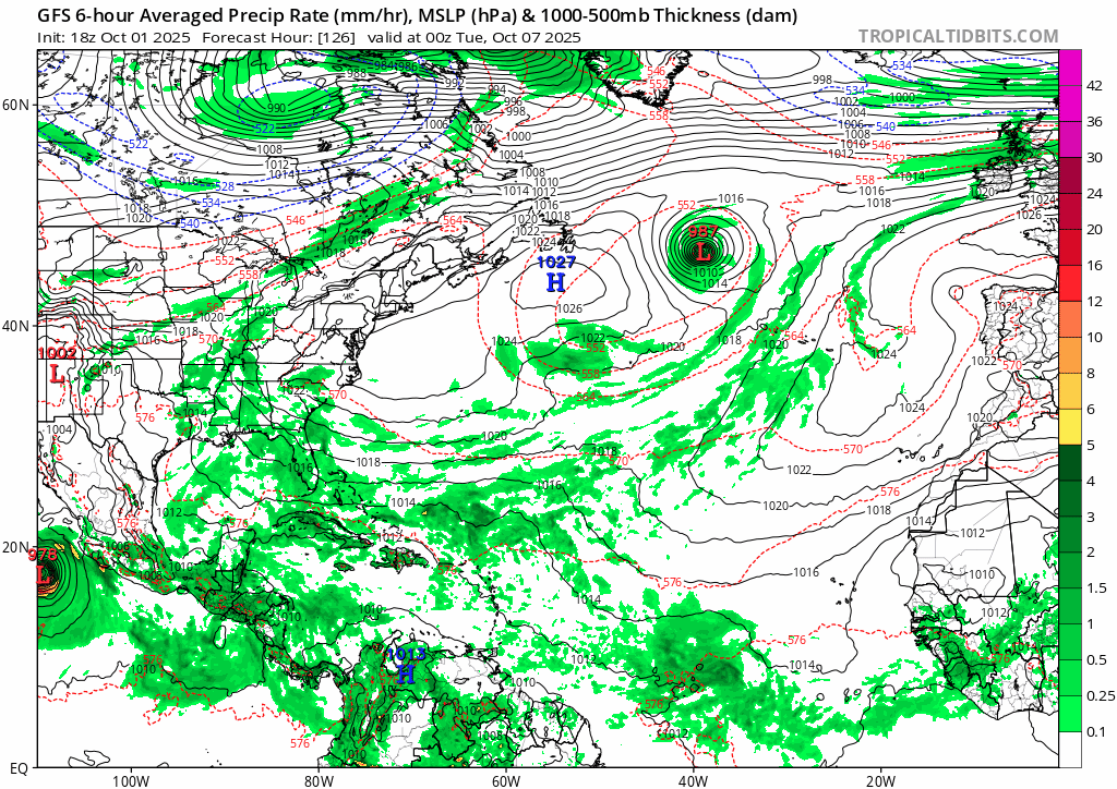
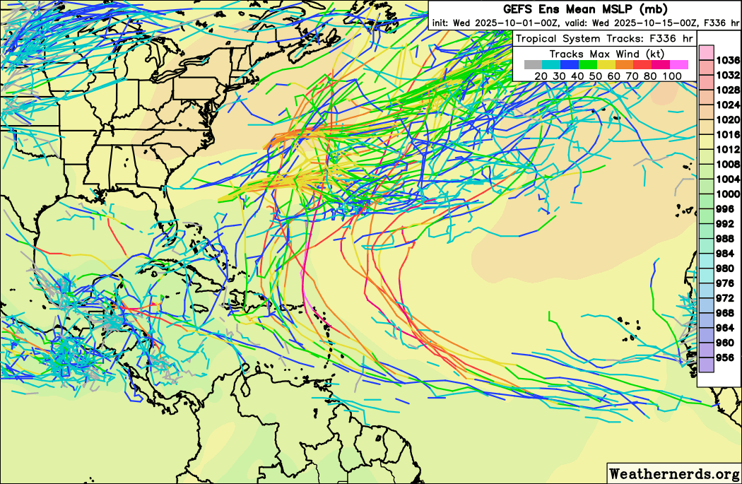
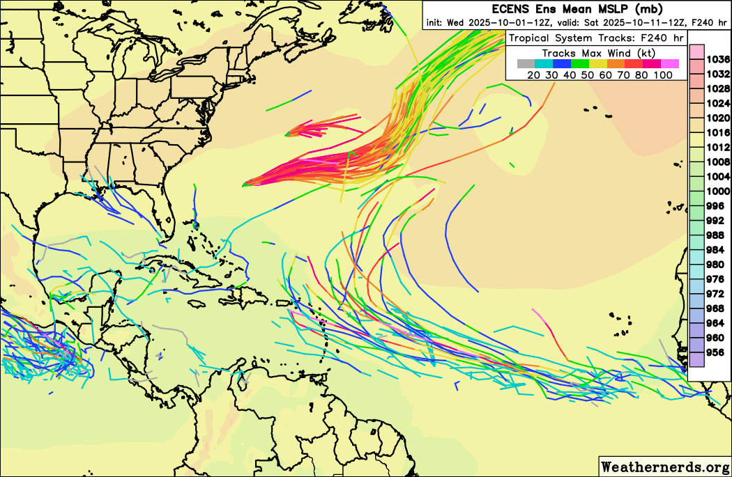
1. Central Tropical Atlantic:
A tropical wave is expected to move off the coast of Africa over the
next day or two. Thereafter, this wave is forecast to interact with
another disturbance in the eastern tropical Atlantic, and some slow
development of the combined feature is possible as the system moves
westward to west-northwestward at 15 to 20 mph.
* Formation chance through 48 hours...low...near 0 percent.
* Formation chance through 7 days...low...20 percent.


Image
3 likes   
Visit the Caribbean-Central America Weather Thread where you can find at first post web cams,radars
and observations from Caribbean basin members Click Here

canes92
Tropical Storm
Tropical Storm
Posts: 140
Age: 32
Joined: Tue Mar 06, 2018 1:51 pm

Re: Tropical Wave to emerge from West Africa in a day or two (0/20)

#2 Postby canes92 » Wed Oct 01, 2025 7:04 pm

Just stay away from Florida lol
4 likes   

User avatar
Category5Kaiju
Category 5
Category 5
Posts: 4285
Joined: Thu Dec 24, 2020 12:45 pm
Location: Seattle and Phoenix

Re: Tropical Wave to emerge from West Africa in a day or two (0/20)

#3 Postby Category5Kaiju » Wed Oct 01, 2025 7:25 pm

I know the 18z GFS run (and, for that matter, the recent string of GFS runs) have been the topic of quite some chatter. It's obviously getting late into the season as we're firmly in fall now, so....you may wonder, is it even possible to have a significant, MDR-born hurricane threaten the CONUS, especially the East Coast, this late in the year?

The answer to this question is yes, albeit very rare. Two hurricanes come to mind: Matthew from 2016 and Hazel from 1954. They also took very similar paths, being pulled north from the ECAR and then northwestward enough that they basically came into contact with the East Coast. Now, it's still extremely early and there's certainly reason to doubt that such a kind of situation would arise with this future system, but in a late-blooming year with still-warm ssts and -ENSO-boosted favorable wind shear levels and that stuff, one has to wonder if *this* storm might be somewhat more of interest to watch, especially for land, compared to the many recurving storms we've had recently
5 likes   
Unless explicitly stated, all info in my posts is based on my own opinions and observations. Tropical storms and hurricanes can be extremely dangerous. Refer to an accredited weather research agency or meteorologist if you need to make serious decisions regarding an approaching storm.

User avatar
Teban54
Category 5
Category 5
Posts: 3761
Joined: Sat May 19, 2018 1:19 pm

Re: Tropical Wave to emerge from West Africa in a day or two (0/20)

#4 Postby Teban54 » Wed Oct 01, 2025 8:03 pm

:lol: :lol: :lol: or :double: ?

Image
5 likes   

User avatar
cycloneye
Admin
Admin
Posts: 148478
Age: 69
Joined: Thu Oct 10, 2002 10:54 am
Location: San Juan, Puerto Rico

Re: Tropical Wave to emerge from West Africa in a day or two (0/20)

#5 Postby cycloneye » Wed Oct 01, 2025 8:13 pm

0 likes   
Visit the Caribbean-Central America Weather Thread where you can find at first post web cams,radars
and observations from Caribbean basin members Click Here

User avatar
Teban54
Category 5
Category 5
Posts: 3761
Joined: Sat May 19, 2018 1:19 pm

Re: Tropical Wave to emerge from West Africa in a day or two (0/20)

#6 Postby Teban54 » Wed Oct 01, 2025 8:48 pm

GEFS trend over the past 24 hours. Stronger signals at 6z and 18z, weaker at 0z and 12z. Unlike the operational runs, ensembles mostly recurve well east of CONUS - but some only after impacting the Lesser Antilles (or even entering NE Caribbean proper).

Image

12z EPS at the end of the run. Intensity is a mixed bag, but there are some strong hurricanes. Track is inconclusive given the shorter lead time.

Image

A possible analog is Tammy 2023, another unusually late CV hurricane:

Image
4 likes   

emeraldislenc
Category 2
Category 2
Posts: 601
Joined: Fri Aug 24, 2012 4:49 pm
Location: Emerald Isle NC

Re: Tropical Wave to emerge from West Africa in a day or two (0/20)

#7 Postby emeraldislenc » Wed Oct 01, 2025 9:04 pm

Glad someone mentioned Hazel in 1954. It came from the Atlantic then to the Caribbean did tremendous damage in Haiti and then came ashore near Calabash. Did extensive damage to the Coastal Carolina's then marched north through NC and the U.S. and wound up in Canada. A storm to remember. I remember Hazel!
2 likes   

User avatar
ConvergenceZone
Category 5
Category 5
Posts: 5240
Joined: Fri Jul 29, 2005 1:40 am
Location: Northern California

Re: Tropical Wave to emerge from West Africa in a day or two (0/20)

#8 Postby ConvergenceZone » Wed Oct 01, 2025 10:57 pm

it's that time of year when fronts sweeping across the US are really going to be on the increase. I mean even here in California we are getting early rains which is unusual for late September. But the increase in fronts SHOULD protect the east coast for the rest of the season. I think if anything is going to affect the USA, it will need to come from the Gulf, and not really seeing anything on the radar for the next 2 weeks, so if we are lucky we might be in the clear until 2026. Never say never, but I like what I'm seeing on the extended outlook.
3 likes   

User avatar
DorkyMcDorkface
Category 4
Category 4
Posts: 960
Age: 27
Joined: Mon Sep 30, 2019 1:32 pm
Location: Mid-Atlantic

Re: Tropical Wave to emerge from West Africa in a day or two (0/20)

#9 Postby DorkyMcDorkface » Wed Oct 01, 2025 11:36 pm

Yeah ok, October Cruiser, why not. As if this season hasn't been strange enough
Image
3 likes   
Please note the thougths expressed by this account are solely those of the user and are from a hobbyist perspective. For more comprehensive analysis, consult an actual professional meteorologist or meteorology agency.


Floyd 1999 | Isabel 2003 | Hanna 2008 | Irene 2011 | Sandy 2012 | Isaias 2020

User avatar
cycloneye
Admin
Admin
Posts: 148478
Age: 69
Joined: Thu Oct 10, 2002 10:54 am
Location: San Juan, Puerto Rico

Re: Tropical Wave to emerge from West Africa in a day or two (0/20)

#10 Postby cycloneye » Thu Oct 02, 2025 1:33 am

Tropical Weather Outlook
NWS National Hurricane Center Miami FL
200 AM EDT Thu Oct 2 2025


Central Tropical Atlantic:
A tropical wave is expected to move off the coast of Africa over the
next day or two. Thereafter, this wave is forecast to interact with
another disturbance in the eastern tropical Atlantic, and some slow
development of the combined feature is possible as the system moves
westward to west-northwestward at 15 to 20 mph.
* Formation chance through 48 hours...low...near 0 percent.
* Formation chance through 7 days...low...20 percent.
0 likes   
Visit the Caribbean-Central America Weather Thread where you can find at first post web cams,radars
and observations from Caribbean basin members Click Here

User avatar
CFLHurricane
Category 1
Category 1
Posts: 349
Joined: Thu Mar 27, 2014 5:56 pm
Location: Floriduh

Re: Tropical Wave to emerge from West Africa in a day or two (0/20)

#11 Postby CFLHurricane » Thu Oct 02, 2025 2:12 am

ConvergenceZone wrote:I think if anything is going to affect the USA, it will need to come from the Gulf, and not really seeing anything on the radar for the next 2 weeks, so if we are lucky we might be in the clear until 2026. Never say never, but I like what I'm seeing on the extended outlook.


I agree this assessment has been spot on, and extend it to this entire season. This is a season the AEWs take a backseat to CAGs, as far as CONUS is concerned.
1 likes   
I'm not a meteorologist, but I did stay at a motel 8.

User avatar
kevin
Category 5
Category 5
Posts: 2877
Age: 27
Joined: Wed Aug 28, 2019 4:35 am

Re: Tropical Wave to emerge from West Africa in a day or two (0/20)

#12 Postby kevin » Thu Oct 02, 2025 6:38 am

About 60% of members on the 06z GEFS show a TC at day 6 (+144hr).

Image
4 likes   

User avatar
cycloneye
Admin
Admin
Posts: 148478
Age: 69
Joined: Thu Oct 10, 2002 10:54 am
Location: San Juan, Puerto Rico

Re: Tropical Wave to emerge from West Africa in a day or two (0/20)

#13 Postby cycloneye » Thu Oct 02, 2025 6:46 am

8 AM:

Central Tropical Atlantic:
A tropical wave is expected to move off the coast of Africa over the
next day or two. Thereafter, this wave is forecast to interact with
another disturbance in the eastern tropical Atlantic, and some slow
development of the combined feature is possible as the system moves
westward to west-northwestward at 15 to 20 mph.
* Formation chance through 48 hours...low...near 0 percent.
* Formation chance through 7 days...low...20 percent.
0 likes   
Visit the Caribbean-Central America Weather Thread where you can find at first post web cams,radars
and observations from Caribbean basin members Click Here

Cachondo23
Tropical Storm
Tropical Storm
Posts: 131
Joined: Wed May 25, 2022 5:56 am

Re: Tropical Wave to emerge from West Africa in a day or two (0/20)

#14 Postby Cachondo23 » Thu Oct 02, 2025 8:33 am

kevin wrote:About 60% of members on the 06z GEFS show a TC at day 6 (+144hr).

https://i.imgur.com/kI8XPn5.png

Even if it stays low, we know the drill this season… all at the end just wants to recurve before the Lesser Antilles but, as always, too early to really know the outcome.
1 likes   

User avatar
Teban54
Category 5
Category 5
Posts: 3761
Joined: Sat May 19, 2018 1:19 pm

Re: Tropical Wave to emerge from West Africa in a day or two (0/20)

#15 Postby Teban54 » Thu Oct 02, 2025 9:04 am

Operational GFS has a Maine landfall two runs in a row. Even though it's obviously way too far out, and even if you ignore impacts to the Caribbean islands, it shows that CONUS impacts are still possible.
0 likes   

User avatar
cycloneye
Admin
Admin
Posts: 148478
Age: 69
Joined: Thu Oct 10, 2002 10:54 am
Location: San Juan, Puerto Rico

Re: Tropical Wave to emerge from West Africa in a day or two (0/20)

#16 Postby cycloneye » Thu Oct 02, 2025 12:49 pm

2 PM:

Central Tropical Atlantic:
A tropical wave is expected to move off the coast of Africa over the
next day or two. Thereafter, this wave is forecast to interact with
another disturbance in the eastern tropical Atlantic, and some slow
development of the combined feature is possible as the system moves
westward to west-northwestward at 15 to 20 mph.
* Formation chance through 48 hours...low...near 0 percent.
* Formation chance through 7 days...low...20 percent.
0 likes   
Visit the Caribbean-Central America Weather Thread where you can find at first post web cams,radars
and observations from Caribbean basin members Click Here

User avatar
cycloneye
Admin
Admin
Posts: 148478
Age: 69
Joined: Thu Oct 10, 2002 10:54 am
Location: San Juan, Puerto Rico

Re: Tropical Wave to emerge from West Africa in a day or two (0/20)

#17 Postby cycloneye » Thu Oct 02, 2025 1:05 pm

12z EURO develops and is a wild drive to the SW at the end. It moves thru the NE Caribbean islands, then it goes SW thru DR and Haiti and reaches the Caribbean sea. :eek:

Image
3 likes   
Visit the Caribbean-Central America Weather Thread where you can find at first post web cams,radars
and observations from Caribbean basin members Click Here

User avatar
cycloneye
Admin
Admin
Posts: 148478
Age: 69
Joined: Thu Oct 10, 2002 10:54 am
Location: San Juan, Puerto Rico

Re: Tropical Wave to emerge from West Africa in a day or two (0/20)

#18 Postby cycloneye » Thu Oct 02, 2025 1:13 pm

Image

It ends here. :eek:

Image
4 likes   
Visit the Caribbean-Central America Weather Thread where you can find at first post web cams,radars
and observations from Caribbean basin members Click Here

User avatar
Hurricane2022
Category 5
Category 5
Posts: 1932
Joined: Tue Aug 23, 2022 11:38 pm
Location: Araçatuba, Brazil

Re: Tropical Wave to emerge from West Africa in a day or two (0/20)

#19 Postby Hurricane2022 » Thu Oct 02, 2025 1:16 pm


It seems like a GFS-ish run to me. :lol:
0 likes   
Sorry for the bad English sometimes...!
For reliable and detailed information for any meteorological phenomenon, please consult the National Hurricane Center, Joint Typhoon Warning Center , or your local Meteo Center.

--------

ECCE OMNIA NOVA FACIAM (Ap 21,5).

User avatar
AnnularCane
S2K Supporter
S2K Supporter
Posts: 2945
Joined: Thu Jun 08, 2006 9:18 am
Location: Wytheville, VA

Re: Tropical Wave to emerge West Africa in a day or two (0/20)

#20 Postby AnnularCane » Thu Oct 02, 2025 1:36 pm


Ouch, right through the Shredder. :sick:

Doesn't seem to hurt it too much though. :lol:
0 likes   
"But it never rained rain. It never snowed snow. And it never blew just wind. It rained things like soup and juice. It snowed mashed potatoes and green peas. And sometimes the wind blew in storms of hamburgers." -- Judi Barrett, Cloudy with a Chance of Meatballs


Return to “Talkin' Tropics”

Who is online

Users browsing this forum: ncforecaster89 and 68 guests