Just had a crazy question that popped into my head.
How many hurricane eyes have you actually been through? I'm talking actually in the eye.
If my fuzzy brain is remembering correctly I have been in the eye of 4. Flossy, Alma, Alicia, and Beryl.
I have no idea how many tropical storms and hurricanes I have actually experienced since I have lived on or very near the Gulf coast since 1954. We are currently living 90 miles inland, which is the fartherest from the coast I have ever lived.
This should be an interesting exercise since a large majority of members live close to the coasts(East, Gulf, and of course the Caribbean).
Hurricane eye penetrations
Moderator: S2k Moderators
Forum rules

The posts in this forum are NOT official forecasts and should not be used as such. They are just the opinion of the poster and may or may not be backed by sound meteorological data. They are NOT endorsed by any professional institution or STORM2K. For official information, please refer to products from the National Hurricane Center and National Weather Service.
-
vbhoutex

- Storm2k Executive

- Posts: 29150
- Age: 74
- Joined: Wed Oct 09, 2002 11:31 pm
- Location: Cypress, TX
- Contact:
Hurricane eye penetrations
0 likes
Skywarn, C.E.R.T.
Please click below to donate to STORM2K to help with the expenses of keeping the site going:

Please click below to donate to STORM2K to help with the expenses of keeping the site going:
-
cycloneye

- Admin
- Posts: 149680
- Age: 69
- Joined: Thu Oct 10, 2002 10:54 am
- Location: San Juan, Puerto Rico
Re: Hurricane eye penetrations
Here in Puerto Rico I have been thru Georges eye in 1998 and in Maria's one in 2017. in 1989, Hugo's eye moved to my east by 30 miles. Dont want to go thru that again.
1 likes
Visit the Caribbean-Central America Weather Thread where you can find at first post web cams,radars
and observations from Caribbean basin members Click Here
and observations from Caribbean basin members Click Here


Re: Hurricane eye penetrations
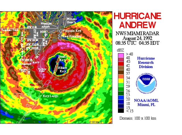
29 eyes experienced 1964-2011
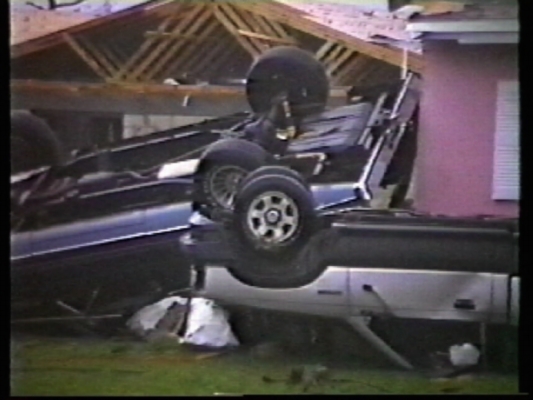
We missed Andrew's eye by 2 1/2 miles on the north side, in S.Miami-Dade, but saw my strongest winds----NHC survey pinned gusts of 175 mph at our locale; which was 40 ft. from this image. Pressure in eye was 922 mb, we recorded 942 mb.
 .
.
.
We missed Andrew's eye by 2 1/2 miles on the north side, in S.Miami-Dade, but saw my strongest winds----NHC survey pinned gusts of 175 mph at our locale; which was 40 ft. from this image. Pressure in eye was 922 mb, we recorded 942 mb.
. .
Last edited by canebeard on Thu Oct 02, 2025 3:37 am, edited 9 times in total.
0 likes
List of 79 tropical cyclones intercepted by Richard Horodner:
http://www.canebeard.com/page/page/572246.htm
former storm2k screenname Beoumont 2009+
http://www.canebeard.com/page/page/572246.htm
former storm2k screenname Beoumont 2009+
-
storm_in_a_teacup

- Category 2

- Posts: 500
- Age: 33
- Joined: Wed Aug 16, 2017 5:01 pm
- Location: Huntsville, Alabama (originally from Houston)
- Contact:
Re: Hurricane eye penetrations
I’ve never been in the eye, but my parents have. My dad was in Ike, and my mom was in Beryl.
To be fair whenever there’s a hurricane I kinda run away. I’m a total coward.
To be fair whenever there’s a hurricane I kinda run away. I’m a total coward.
0 likes
I know I can't straddle the atmosphere...just a tiny storm in your teacup, girl.
-
AnnularCane

- S2K Supporter

- Posts: 2964
- Joined: Thu Jun 08, 2006 9:18 am
- Location: Wytheville, VA
Re: Hurricane eye penetrations
Despite living in southeast Louisiana (including New Orleans itself) for much of my life, and dealing with many tropical storms and hurricanes, I don't think I've been in a single eye that I can recall. Probably because the NOLA area usually tended to be missed by the eye itself, plus we evacuated from the big ones. Had I been there for Zeta, however, I might have seen it since the eye apparently went right over the city.
0 likes
"But it never rained rain. It never snowed snow. And it never blew just wind. It rained things like soup and juice. It snowed mashed potatoes and green peas. And sometimes the wind blew in storms of hamburgers." -- Judi Barrett, Cloudy with a Chance of Meatballs

Re: Hurricane eye penetrations
vbhoutex wrote:Just had a crazy question that popped into my head.
How many hurricane eyes have you actually been through? I'm talking actually in the eye.
If my fuzzy brain is remembering correctly I have been in the eye of 4. Flossy, Alma, Alicia, and Beryl.
I have no idea how many tropical storms and hurricanes I have actually experienced since I have lived on or very near the Gulf coast since 1954. We are currently living 90 miles inland, which is the fartherest from the coast I have ever lived.
This should be an interesting exercise since a large majority of members live close to the coasts(East, Gulf, and of course the Caribbean).
Great question. I'm going to have to recollect whether one or two of my chases quite qualify for having been "in the eye". Including Katrina (S. Florida), Wilma, Hugo (P.R.), Bonnie, & Charlie I'd say at least 7 IF I also include two seperate NOAA flights into hurricanes off the Eastern Seaboard. The eye of Hugo during my chase in Luquillo was certainly my most memorable.
Some hurricane chasers (myself excluded) got "double points" for multiple landfalls where they intercepted a hurricanes eye (eg. Hugo, Katrina, Etc)
0 likes
Andy D
(For official information, please refer to the NHC and NWS products.)
(For official information, please refer to the NHC and NWS products.)
Re: Hurricane eye penetrations
chaser1 wrote:
Some hurricane chasers (myself excluded) got "double points" for multiple landfalls where they intercepted a hurricanes eye (eg. Hugo, Katrina, Etc)
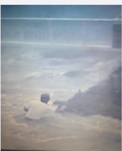
chaser 1, Andrew Pressler, in Hugo's eye, Luquillo, PR date/time stamp on video frame
Last edited by canebeard on Thu Oct 02, 2025 7:40 am, edited 1 time in total.
2 likes
List of 79 tropical cyclones intercepted by Richard Horodner:
http://www.canebeard.com/page/page/572246.htm
former storm2k screenname Beoumont 2009+
http://www.canebeard.com/page/page/572246.htm
former storm2k screenname Beoumont 2009+
Re: Hurricane eye penetrations
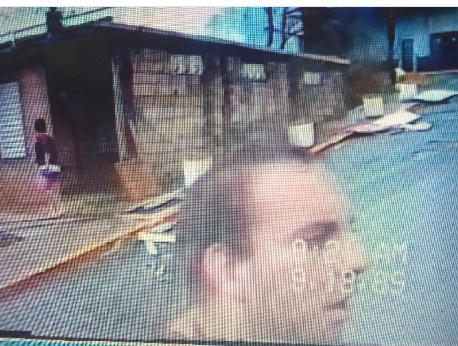
CHaser1, Andy Pressler, in highest tidal surge in Cape Hatteras history, 10.2 feet, at Buxton, NC1993--Hurricane Emily
Last edited by canebeard on Thu Oct 02, 2025 12:34 pm, edited 1 time in total.
3 likes
List of 79 tropical cyclones intercepted by Richard Horodner:
http://www.canebeard.com/page/page/572246.htm
former storm2k screenname Beoumont 2009+
http://www.canebeard.com/page/page/572246.htm
former storm2k screenname Beoumont 2009+
Re: Hurricane eye penetrations
canebeard wrote:29 eyes experienced 1964-2011
We missed Andrew's eye by 2 1/2 miles on the north side, in S.Miami-Dade, but saw my strongest winds----NHC survey pinned gusts of 175 mph at our locale; which was 40 ft. from this image. Pressure in eye was 922 mb, we recorded 942 mb.
https://www.hurricanevideo.citymax.com/i/Album/cars_over.jpg .
.
Where were you in Dade County? I am assuming just south of Kendall?
0 likes
Andrew (1992), Irene (1999), Frances (2004), Katrina (2005), Wilma (2005), Fay (2008), Irma (2017), Eta (2020), Ian (2022)
Re: Hurricane eye penetrations
Nuno wrote:canebeard wrote:29 eyes experienced 1964-2011
We missed Andrew's eye by 2 1/2 miles on the north side, in S.Miami-Dade, but saw my strongest winds----NHC survey pinned gusts of 175 mph at our locale; which was 40 ft. from this image. Pressure in eye was 922 mb, we recorded 942 mb.
https://www.hurricanevideo.citymax.com/i/Album/cars_over.jpg .
.
Where were you in Dade County? I am assuming just south of Kendall?
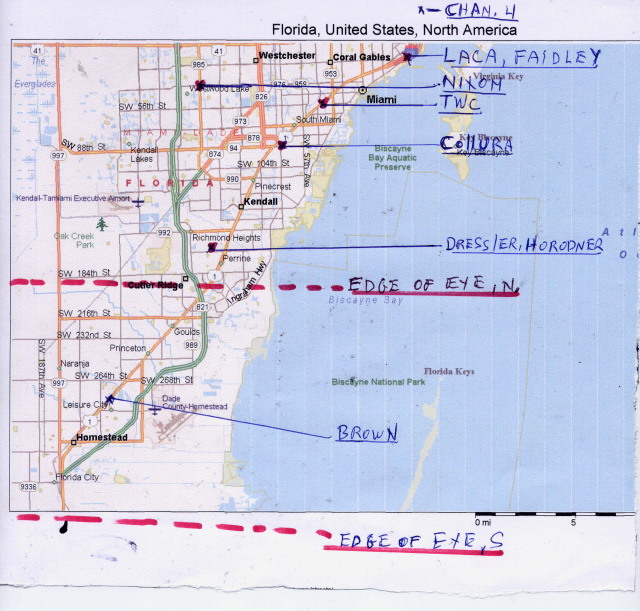
We were on SW 159 st and 99 AVE, Just west of US 1, where it says Dressler/Horodner
https://www.hurricanevideo.citymax.com/andrew.html , This URl leads to a written acccout of this "chase"
3 likes
List of 79 tropical cyclones intercepted by Richard Horodner:
http://www.canebeard.com/page/page/572246.htm
former storm2k screenname Beoumont 2009+
http://www.canebeard.com/page/page/572246.htm
former storm2k screenname Beoumont 2009+
Re: Hurricane eye penetrations
canebeard wrote:Nuno wrote:canebeard wrote:29 eyes experienced 1964-2011
We missed Andrew's eye by 2 1/2 miles on the north side, in S.Miami-Dade, but saw my strongest winds----NHC survey pinned gusts of 175 mph at our locale; which was 40 ft. from this image. Pressure in eye was 922 mb, we recorded 942 mb.
https://www.hurricanevideo.citymax.com/i/Album/cars_over.jpg .
.
Where were you in Dade County? I am assuming just south of Kendall?
We were on SW 159 st and 99 AVE, Just west of US 1, where it says Dressler/Horodner
https://www.hurricanevideo.citymax.com/andrew.html , This URl leads to a written acccout of this "chase"
https://www.hurricanevideo.citymax.com/i/1.jpg
https://www.hurricanevideo.citymax.com/i/andnewradar.JPG
Fascinating ive come across this page and didnt realize it was you. Do you know where I can find Terry Nixon's account or data? He was located not far from where we were as the storm passed.
0 likes
Andrew (1992), Irene (1999), Frances (2004), Katrina (2005), Wilma (2005), Fay (2008), Irma (2017), Eta (2020), Ian (2022)
Re: Hurricane eye penetrations
canebeard wrote:chaser1 wrote:
Some hurricane chasers (myself excluded) got "double points" for multiple landfalls where they intercepted a hurricanes eye (eg. Hugo, Katrina, Etc)
chaser 1, Andrew Pressler, in Hugo's eye, Luquillo, PR date/time stamp on video frame
[url]https://i.postimg.cc/sDxKK3Bt/Screenshot-2025-10-02-3-02-06-AM.png [/url]
I still had hair back then

0 likes
Andy D
(For official information, please refer to the NHC and NWS products.)
(For official information, please refer to the NHC and NWS products.)
Re: Hurricane eye penetrations
Nuno wrote:Fascinating ive come across this page and didnt realize it was you. Do you know where I can find Terry Nixon's account or data? He was located not far from where we were as the storm passed.
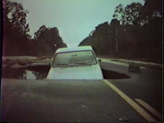
Terry chased solely for fun. His account is in his 79 year old head. He was probably the first "storm" chaser to mount an anemometer on his vehicle (a pick-up--with a thick plexiglass shield mounted behind the back window, and 1000+ lbs of bagged rocks in the truckbed for vehicle stability). His first chase was with older FSU students, including later to be NWS executive Joe Golden, after Hurricane Betsy in 1965. We then chased in tandem or together until Hugo, 1989 and Trudy, 1990 to Cabo San Lucas. Andrew was his last chase. He refused to ever take video, as that would just take away from his pure enjoyment and scientific fascination.
In 1985, during Hurricane Kate, at Cape San Blas, Florida, we split up and I drove to Mexico Beach to get into the eye. He stayed at the waterfront park to get into the strongest winds in the NE quadrant. As the 11 ft. surge was rising he went to leave the waterfront, and the park highway got undercut by the flowing Gulf of MEXICO. His truck fell through the highway, submerging the cab only. So he spent the pitch black night in the truck bed and hurricane winds and driving rain, which stayed above water. Brrrr.
0 likes
List of 79 tropical cyclones intercepted by Richard Horodner:
http://www.canebeard.com/page/page/572246.htm
former storm2k screenname Beoumont 2009+
http://www.canebeard.com/page/page/572246.htm
former storm2k screenname Beoumont 2009+
Re: Hurricane eye penetrations
canebeard wrote:Nuno wrote:Fascinating ive come across this page and didnt realize it was you. Do you know where I can find Terry Nixon's account or data? He was located not far from where we were as the storm passed.
Terry chased solely for fun. His account is in his 79 year old head. He was probably the first "storm" chaser to mount an anemometer on his vehicle (a pick-up--with a thick plexiglass shield mounted behind the back window, and 1000+ lbs of bagged rocks in the truckbed for vehicle stability). His first chase was with older FSU students, including later to be NWS executive Joe Golden, after Hurricane Betsy in 1965. We then chased in tandem or together until Hugo, 1989 and Trudy, 1990 to Cabo San Lucas. Andrew was his last chase. He refused to ever take video, as that would just take away from his pure enjoyment and scientific fascination.
In 1985, during Hurricane Kate, at Cape San Blas, Florida, we split up and I drove to Mexico Beach to get into the eye. He stayed at the waterfront park to get into the strongest winds in the NE quadrant. As the 11 ft. surge was rising he went to leave the waterfront, and the park highway got undercut by the flowing Gulf of MEXICO. His truck fell through the highway, submerging the cab only. So he spent the pitch black night in the truck bed and hurricane winds and driving rain, which stayed above water. Brrrr.
https://www.hurricanevideo.citymax.com/i/Album/truck_front.jpg
THAT was a classic memory forged out of what then began as the wild wild west of Storm Chasing! There were no portable remote computers with live weather data feeds, instantaneous satellite access, or live radar at our fingertips. Those big bulky VHS recorders were about as high tech that I recall existing back then. It brings back memories.
I think the last time I saw/spoke to Terry was in San Juan (Hugo). Any idea how he's doing?
1 likes
Andy D
(For official information, please refer to the NHC and NWS products.)
(For official information, please refer to the NHC and NWS products.)
Re: Hurricane eye penetrations
Some of you folks in Bermuda have been in the eye of one or more hurricanes! I'm thinking 3 or 4 during the past 10 or so years?
0 likes
Andy D
(For official information, please refer to the NHC and NWS products.)
(For official information, please refer to the NHC and NWS products.)
-
AJC3

- Admin
- Posts: 4156
- Age: 62
- Joined: Tue Aug 31, 2004 7:04 pm
- Location: Ballston Spa, New York
- Contact:
Re: Hurricane eye penetrations
Almost 30 years as a met at NWS Melbourne...ZERO eyes. Came the closest my 2nd year there (1995) with Hurricane Erin and my next to last (2022) with Hurricane Nicole. Hurricanes Irene (1999), Matthew (2016), Dorian (2019 EEK!), Isaias (2020), and Milton (2024) were also close calls.
There were also several TS "center" passages overhead, or very nearly so, that I really wouldn't call "eye penetrations": Gabrielle (2001), Henri (2003), Tammy (2005), Ernesto (2006), Fay (2008), Julia (2016), Emily (2017), Ian (2022 - it had weakened).
Ironically, I was out of town for only ONE impacting TC during my entire career - Hurricane Irene in 2011. I was on vacation in upstate NY near the Vermont border, and Irene's center passed by just to our east as a weakening TS while I was up there. The flooding in the area was devastating, and caused us to be stranded at the house we were staying at for a couple days, since the bridges that didn't wind up getting washed away were closed due to either high water or debris jamming up against the abutments.
0 likes
Re: Hurricane eye penetrations
chaser1 wrote:
THAT was a classic memory forged out of what then began as the wild wild west of Storm Chasing! There were no portable remote computers with live weather data feeds, instantaneous satellite access, or live radar at our fingertips. Those big bulky VHS recorders were about as high tech that I recall existing back then. It brings back memories.
I think the last time I saw/spoke to Terry was in San Juan (Hugo). Any idea how he's doing?
Actually the last time you saw him was when we did this interview for "I Witness VIdeo" NBC, the next year, detailing our Hurricane Hugo interception. You, Laca, Terry, Jim Leonard, and myself" This video piece is broken into two parts:
https://www.youtube.com/watch?v=SAU9yKvIIb4&t=16s part 1
https://www.youtube.com/watch?v=ZoZl2AJvG6k&t=187s part 2
One interesting point of the chase was when we brought the two rental cars back, and the clerk remarked, "These are the first two cars we have gotten back since the storm that had NO damage at all."
The most interesting was the famous Hallway From Hell scene, with the water being wind-forced up the stairwell in the Luquillo condo bldg.
1 likes
List of 79 tropical cyclones intercepted by Richard Horodner:
http://www.canebeard.com/page/page/572246.htm
former storm2k screenname Beoumont 2009+
http://www.canebeard.com/page/page/572246.htm
former storm2k screenname Beoumont 2009+
Re: Hurricane eye penetrations
Fascinating accounts. I am starting to do some form of chasing. I drove up to Ian as it exited off the east coast of FL for my first actual chase. I had gotten on the road the day before and got as far as onto 75 but turned around. I know Ft Myers, Sanibel, Port Charlotte well enough which is why I was so uncomfortable thinking of what was to come with so little experience so I ditched it and decided to drive up 95 the next day as the storm was weaker.
I thought baby steps... before Ian the last eyewall I truly had experienced was Wilma or Katrina. I was just north of Andrew's eyewall, not far from Terry Nixon's location on canebeard's map, further east. I had friends who went through that eye and eyewall and required therapy. I understand why some stopped chasing after that storm.
I thought baby steps... before Ian the last eyewall I truly had experienced was Wilma or Katrina. I was just north of Andrew's eyewall, not far from Terry Nixon's location on canebeard's map, further east. I had friends who went through that eye and eyewall and required therapy. I understand why some stopped chasing after that storm.
0 likes
Andrew (1992), Irene (1999), Frances (2004), Katrina (2005), Wilma (2005), Fay (2008), Irma (2017), Eta (2020), Ian (2022)
Re: Hurricane eye penetrations
Nuno wrote:Fascinating accounts. I am starting to do some form of chasing. I drove up to Ian as it exited off the east coast of FL for my first actual chase. I had gotten on the road the day before and got as far as onto 75 but turned around. I know Ft Myers, Sanibel, Port Charlotte well enough which is why I was so uncomfortable thinking of what was to come with so little experience so I ditched it and decided to drive up 95 the next day as the storm was weaker.
I thought baby steps... before Ian the last eyewall I truly had experienced was Wilma or Katrina. I was just north of Andrew's eyewall, not far from Terry Nixon's location on canebeard's map, further east. I had friends who went through that eye and eyewall and required therapy. I understand why some stopped chasing after that storm.
Stick with it Nuno! To be honest though, chasing solo feels like an added element of risk. Plus, it's a whole hell of a lot more fun chasing with a buddy. Had I not met Richard & Jim many years ago, I highly doubt that I would have ventured out on my own.
1 likes
Andy D
(For official information, please refer to the NHC and NWS products.)
(For official information, please refer to the NHC and NWS products.)
Re: Hurricane eye penetrations
canebeard wrote:chaser1 wrote:
THAT was a classic memory forged out of what then began as the wild wild west of Storm Chasing! There were no portable remote computers with live weather data feeds, instantaneous satellite access, or live radar at our fingertips. Those big bulky VHS recorders were about as high tech that I recall existing back then. It brings back memories.
I think the last time I saw/spoke to Terry was in San Juan (Hugo). Any idea how he's doing?
Actually the last time you saw him was when we did this interview for "I Witness VIdeo" NBC, the next year, detailing our Hurricane Hugo interception. You, Laca, Terry, Jim Leonard, and myself" This video piece is broken into two parts:
https://www.youtube.com/watch?v=SAU9yKvIIb4&t=16s part 1
https://www.youtube.com/watch?v=ZoZl2AJvG6k&t=187s part 2
One interesting point of the chase was when we brought the two rental cars back, and the clerk remarked, "These are the first two cars we have gotten back since the storm that had NO damage at all
I had nearly forgotten about those two Canary yellow (Volvo?) rental cars that we drove around Puerto Rico in. Boy, they weren't conspicuous at all, right LOL?
1 likes
Andy D
(For official information, please refer to the NHC and NWS products.)
(For official information, please refer to the NHC and NWS products.)
Who is online
Users browsing this forum: No registered users and 209 guests