
2025 Global Model Runs Discussion (Out thru day 16)
Moderator: S2k Moderators
Forum rules

The posts in this forum are NOT official forecasts and should not be used as such. They are just the opinion of the poster and may or may not be backed by sound meteorological data. They are NOT endorsed by any professional institution or STORM2K. For official information, please refer to products from the National Hurricane Center and National Weather Service.
Re: 2025 Global Model Runs Discussion (Out thru day 16)
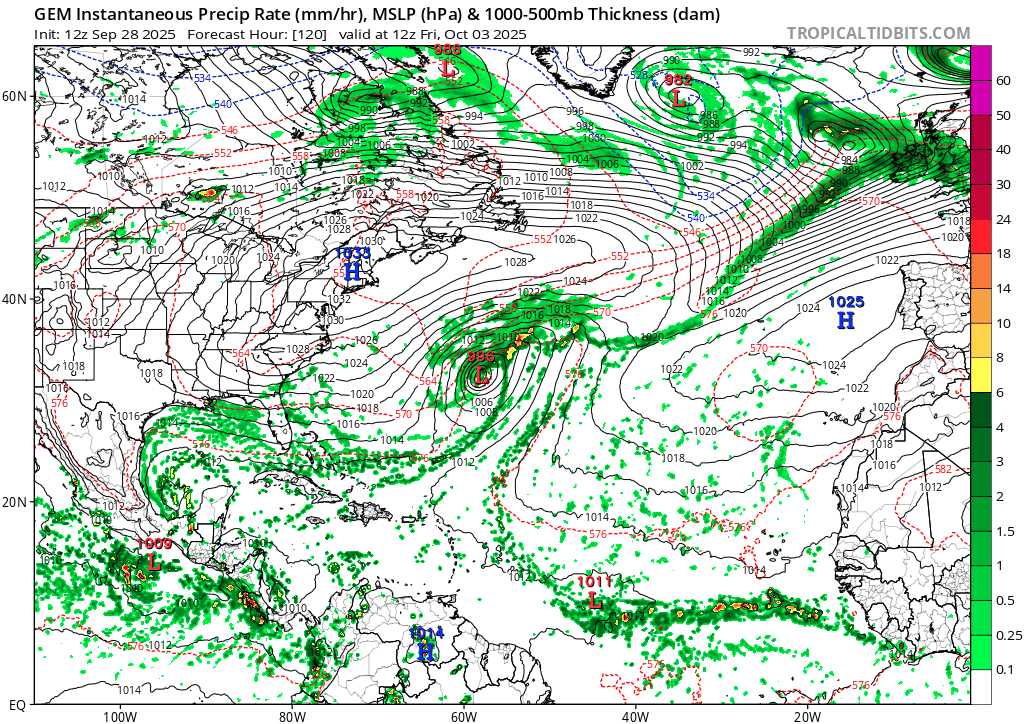
For clarity, this is what 12z CMC showed (as discussed above), near the end of the run.
2 likes
TC naming lists: retirements and intensity
Most aggressive Advisory #1's in North Atlantic (cr. kevin for starting the list)
Most aggressive Advisory #1's in North Atlantic (cr. kevin for starting the list)
-
SFLcane

- S2K Supporter

- Posts: 10281
- Age: 48
- Joined: Sat Jun 05, 2010 1:44 pm
- Location: Lake Worth Florida
Re: 2025 Global Model Runs Discussion (Out thru day 16)
ECMWF weeklies suggesting things are about to kick into overdrive in our backyard which ultimately leads to impacts for someone.

8 likes
Re: 2025 Global Model Runs Discussion (Out thru day 16)
TomballEd wrote:Weathertracker96 wrote:The CMC is showing a Gulf/CAG system.
Larry Cosgrove thinks there may be 2 or 3 storms from the CAG, and it is possible one of them develops in the Gulf or crosses Tehuantepec into the Gulf. Florida has been unlucky with late season storms.
https://groups.google.com/g/weatheramerica/c/aauyOY32C94
Current GOMEX feature on the tail end of the trough almost certainly will not develop, it is in a desert.
https://i.imgur.com/0BOlYx4.gif
Hey Ed,
Yeah, the current central Gulf feature may not develop. However, fwiw, the 0Z UKMET (a model that tends to be a bit more stingy with TCG than the GFS) is the 2nd run in a row that develops a TC from it after it moves S into the Bay of Campeche. This run actually has minimal TS winds early on. Whereas the prior run then moved it into a threatening position in the W-C Gulf, this run only moves it slowly back N to the end of the run:
NEW TROPICAL CYCLONE FORECAST TO DEVELOP AFTER 108 HOURS
FORECAST POSITION AT T+108 : 19.9N 94.7W
LEAD CENTRAL MAXIMUM WIND
VERIFYING TIME TIME POSITION PRESSURE (MB) SPEED (KNOTS)
-------------- ---- -------- ------------- -------------
1200UTC 03.10.2025 108 19.9N 94.7W 1009 36
0000UTC 04.10.2025 120 19.7N 93.9W 1008 31
1200UTC 04.10.2025 132 19.5N 93.9W 1006 31
0000UTC 05.10.2025 144 20.1N 94.2W 1005 29
1200UTC 05.10.2025 156 20.2N 94.0W 1005 26
0000UTC 06.10.2025 168 20.7N 94.5W 1004 27
4 likes
Personal Forecast Disclaimer:
The posts in this forum are NOT official forecasts and should not be used as such. They are just the opinion of the poster and may or may not be backed by sound meteorological data. They are NOT endorsed by any professional institution or storm2k.org. For official information, please refer to the NHC and NWS products.
The posts in this forum are NOT official forecasts and should not be used as such. They are just the opinion of the poster and may or may not be backed by sound meteorological data. They are NOT endorsed by any professional institution or storm2k.org. For official information, please refer to the NHC and NWS products.
Re: 2025 Global Model Runs Discussion (Out thru day 16)
A notable number of 6Z EPS members at 144 (~1/3) have a surface low in the Gulf (mainly northern) from something.
0 likes
Personal Forecast Disclaimer:
The posts in this forum are NOT official forecasts and should not be used as such. They are just the opinion of the poster and may or may not be backed by sound meteorological data. They are NOT endorsed by any professional institution or storm2k.org. For official information, please refer to the NHC and NWS products.
The posts in this forum are NOT official forecasts and should not be used as such. They are just the opinion of the poster and may or may not be backed by sound meteorological data. They are NOT endorsed by any professional institution or storm2k.org. For official information, please refer to the NHC and NWS products.

Re: 2025 Global Model Runs Discussion (Out thru day 16)
Another MDR MH on the 06z GFS. Because October is the new September.
The tropical wave which forms into this already leaves Africa in 3 - 4 days and a TD forms around +180hr in this run.

The tropical wave which forms into this already leaves Africa in 3 - 4 days and a TD forms around +180hr in this run.
2 likes
-
Stratton23
- Category 5

- Posts: 3574
- Joined: Fri Jul 21, 2023 10:59 pm
- Location: Katy, Tx
Re: 2025 Global Model Runs Discussion (Out thru day 16)
12z ICON has something brewing in the southern gulf
0 likes
-
Stormlover70
- Tropical Storm

- Posts: 194
- Age: 56
- Joined: Fri Jun 21, 2024 5:31 am
- Location: New port richey
Re: 2025 Global Model Runs Discussion (Out thru day 16)
image?Stratton23 wrote:12z ICON has something brewing in the southern gulf
0 likes
-
cycloneye

- Admin

- Posts: 149696
- Age: 69
- Joined: Thu Oct 10, 2002 10:54 am
- Location: San Juan, Puerto Rico
Re: 2025 Global Model Runs Discussion (Out thru day 16)
12z GFS has a MDR wave developing.

2 likes
Visit the Caribbean-Central America Weather Thread where you can find at first post web cams,radars
and observations from Caribbean basin members Click Here
and observations from Caribbean basin members Click Here
-
Weathertracker96
- Tropical Storm
- Posts: 150
- Joined: Mon Oct 16, 2023 3:41 pm
Re: 2025 Global Model Runs Discussion (Out thru day 16)
The 12z CMC is showing Gulf & Bahamas activity.
0 likes
-
Stratton23
- Category 5
- Posts: 3574
- Joined: Fri Jul 21, 2023 10:59 pm
- Location: Katy, Tx
Re: 2025 Global Model Runs Discussion (Out thru day 16)
CMC/ GFS also show activity in the southern and western gulf
0 likes
-
cycloneye
- Admin
- Posts: 149696
- Age: 69
- Joined: Thu Oct 10, 2002 10:54 am
- Location: San Juan, Puerto Rico
Re: 2025 Global Model Runs Discussion (Out thru day 16)
Moves thru the northern Leewards and then recurves.

0 likes
Visit the Caribbean-Central America Weather Thread where you can find at first post web cams,radars
and observations from Caribbean basin members Click Here
and observations from Caribbean basin members Click Here
Re: 2025 Global Model Runs Discussion (Out thru day 16)
Stratton23 wrote:CMC/ GFS also show activity in the southern and western gulf
So, that makes Icon, GFS, and CMC as having Gulf tropical activity. So, the Gulf looks somewhat active (more active than most of the season so far in the day 8 or earlier output). However, the UKMET, which goes out only 168, did drop the Gulf TC per its textual output that it had on its prior 2 runs.
1 likes
Personal Forecast Disclaimer:
The posts in this forum are NOT official forecasts and should not be used as such. They are just the opinion of the poster and may or may not be backed by sound meteorological data. They are NOT endorsed by any professional institution or storm2k.org. For official information, please refer to the NHC and NWS products.
The posts in this forum are NOT official forecasts and should not be used as such. They are just the opinion of the poster and may or may not be backed by sound meteorological data. They are NOT endorsed by any professional institution or storm2k.org. For official information, please refer to the NHC and NWS products.
Re: 2025 Global Model Runs Discussion (Out thru day 16)
Summaries of the potential systems (especially as there's a lot of confusion due to overlapping areas).
1. Low currently in the Gulf (potential in 3-7 days)
1. Low currently in the Gulf (potential in 3-7 days)
- There's currently a naked swirl in the western Gulf, largely devoid of convection. Surrounding environment is very dry.
- 12z ICON gets this south to the BoC where it develops. The last frame, in 7.5 days, moves it west towards Mexico as a 988 mb TS/H.
- All other models have the vorticity buried in Mexico.
- There's an MDR wave at 45W firing convection.
- 12z CMC gets this to north of Greater Antilles, where it develops and heads west. It might also have merged with the tail of the front. The last frame, in 10 days, has it approaching SE Florida as a 1006 mb TS.
- 12z GFS appears to turn the tail end of the front into a TC in the NE Gulf by itself, which quickly landfalls in NOLA as a 1004 mb TS in 6 days
- No other models develop this, and have the wave killed off by the recurving Humberto and Imelda.
- 12z GFS starts developing this wave once it reaches 45-50W, in ~9 days. It hits the northernmost LA islands as a hurricane, then recurves east of Bermuda with a peak of 948 mb.
- 12z ICON's last frame, in 7.5 days, shows a 1012 mb low at ~35W. It may have kept organizing had the run continued.
- 12z ECMWF-Fast's last frame, in 10 days, shows a weak vort near the Lesser Antilles. (I don't have the full Euro run yet.)
- 12z CMC appears to show a CAG that spans both sides of Central America. The Western Caribbean side appears to become dominant in 7 days, then attempt to tighten in the Gulf. The last frame, in 10 days, shows a lopsided 994 mb TS offshore the TX/Mexico border.
- 12z GFS shows a somewhat similar evolution, but delayed in time. Organization on the Atlantic side is most notable in ~9 days over the Yucatan Peninsula. The system then gets into BoC, peaks at 985 mb, and landfalls in Mexico in 12 days.
- ECMWF hasn't shown any CAG action around this time in recent runs.
9 likes
TC naming lists: retirements and intensity
Most aggressive Advisory #1's in North Atlantic (cr. kevin for starting the list)
Most aggressive Advisory #1's in North Atlantic (cr. kevin for starting the list)
-
Stratton23
- Category 5
- Posts: 3574
- Joined: Fri Jul 21, 2023 10:59 pm
- Location: Katy, Tx
Re: 2025 Global Model Runs Discussion (Out thru day 16)
Well tonights model runs are very interesting so far lol , CMC has a TS in the gulf moving toward central- northern mexico, GFS buries it into BOC, but has another low riding wave developing in the caribbean, not seeing any troughs on the models for october, lots of ridging, not a typical upper air pattern for october
1 likes
-
ConvergenceZone
.gif)
- Category 5
- Posts: 5241
- Joined: Fri Jul 29, 2005 1:40 am
- Location: Northern California
Re: 2025 Global Model Runs Discussion (Out thru day 16)
Stratton23 wrote:Well tonights model runs are very interesting so far lol , CMC has a TS in the gulf moving toward central- northern mexico, GFS buries it into BOC, but has another low riding wave developing in the caribbean, not seeing any troughs on the models for october, lots of ridging, not a typical upper air pattern for october
Yea I was looking at that as well. It's really looking like this year is the year that the USA mainland escapes any tropical disasters.
2 likes
-
Stratton23
- Category 5
- Posts: 3574
- Joined: Fri Jul 21, 2023 10:59 pm
- Location: Katy, Tx
Re: 2025 Global Model Runs Discussion (Out thru day 16)
ConvergenceZone eh i still wouldn’t say that just yet , that ridging pattern could definitely change and parts of the gulf ( mainly eastern gulf) could still be threatened down the road should a system develop and get into the gulf
2 likes
-
TomballEd
- Category 5
- Posts: 1318
- Age: 62
- Joined: Wed Aug 16, 2023 4:52 pm
- Location: Spring/Klein area, not Tomball
Re: 2025 Global Model Runs Discussion (Out thru day 16)
6Z Euro tries to get something going in the Gulf but it is in a desert of dry air. Forgive use of snipping tool, normally I use a mouse to copy the image from the site but I don't have a keyboard or mouse and the little laptop's mousepad doesn't seen to know what a right click is. I don't have the big monitor either.

0 likes
Re: 2025 Global Model Runs Discussion (Out thru day 16)
FWIW The last couple GFS ensemble runs are fairly active in the southern gulf with activity migrating north between days 7-10
0 likes
-
REDHurricane

- Category 1

- Posts: 438
- Age: 28
- Joined: Sun Jul 03, 2022 2:36 pm
- Location: Northeast Pacific Ocean
Re: 2025 Global Model Runs Discussion (Out thru day 16)
ConvergenceZone wrote:Stratton23 wrote:Well tonights model runs are very interesting so far lol , CMC has a TS in the gulf moving toward central- northern mexico, GFS buries it into BOC, but has another low riding wave developing in the caribbean, not seeing any troughs on the models for october, lots of ridging, not a typical upper air pattern for october
Yea I was looking at that as well. It's really looking like this year is the year that the USA mainland escapes any tropical disasters.
This is the kind of comment that is destined to age like milk lol
6 likes
-
SFLcane
- S2K Supporter
- Posts: 10281
- Age: 48
- Joined: Sat Jun 05, 2010 1:44 pm
- Location: Lake Worth Florida
Re: 2025 Global Model Runs Discussion (Out thru day 16)
Certainly a prediction to be taken with caution as this is the CFS but it fits with the favorable upper motion moving in mid month in Oct.


3 likes
Who is online
Users browsing this forum: No registered users and 175 guests