Tropical Wave in the Central Atlantic (Is Invest 93L)

This is the general tropical discussion area. Anyone can take their shot at predicting a storms path.

Moderator: S2k Moderators

Forum rules

The posts in this forum are NOT official forecasts and should not be used as such. They are just the opinion of the poster and may or may not be backed by sound meteorological data. They are NOT endorsed by any professional institution or STORM2K. For official information, please refer to products from the National Hurricane Center and National Weather Service.

Help Support Storm2K
Message
Author
User avatar
cycloneye
Admin
Admin
Posts: 148479
Age: 69
Joined: Thu Oct 10, 2002 10:54 am
Location: San Juan, Puerto Rico

Re: Tropical Wave in the Eastern Atlantic (0/30)

#21 Postby cycloneye » Sun Sep 21, 2025 3:55 am

Tropical Weather Outlook
NWS National Hurricane Center Miami FL
200 AM EDT Sun Sep 21 2025

Eastern and Central Tropical Atlantic:
A tropical wave over the eastern Atlantic is producing disorganized
shower and thunderstorm activity well west-southwest of the Cabo
Verde Islands. Although development is unlikely during the next
couple of days, environmental conditions should gradually become
more favorable for slow development of this disturbance by the
middle to latter part of this week while it moves west-northwestward
to northwestward across the central Atlantic.
* Formation chance through 48 hours...low...near 0 percent.
* Formation chance through 7 days...low...30 percent.


Forecaster Kelly
1 likes   
Visit the Caribbean-Central America Weather Thread where you can find at first post web cams,radars
and observations from Caribbean basin members Click Here

User avatar
cycloneye
Admin
Admin
Posts: 148479
Age: 69
Joined: Thu Oct 10, 2002 10:54 am
Location: San Juan, Puerto Rico

Re: Tropical Wave in the Central Atlantic (0/40)

#22 Postby cycloneye » Sun Sep 21, 2025 6:51 am

Tropical Weather Outlook
NWS National Hurricane Center Miami FL
800 AM EDT Sun Sep 21 2025

Central Tropical Atlantic:
A broad tropical wave moving into the central tropical Atlantic
continues to produce disorganized shower and thunderstorms well to
the west-southwest of the Cabo Verde Islands. Although environmental
conditions are not favorable for initial development of this system
over the next day or two, these conditions should gradually become
more favorable for development by the middle to latter part of this
week, and a tropical depression could form while the system moves
west-northwestward to northwestward across the central Atlantic.
* Formation chance through 48 hours...low...near 0 percent.
* Formation chance through 7 days...medium...40 percent.

$$
Forecaster Papin
1 likes   
Visit the Caribbean-Central America Weather Thread where you can find at first post web cams,radars
and observations from Caribbean basin members Click Here

TomballEd
Category 5
Category 5
Posts: 1073
Age: 61
Joined: Wed Aug 16, 2023 4:52 pm
Location: Spring/Klein area, not Tomball

Re: Tropical Wave in the Central Atlantic (0/40)

#23 Postby TomballEd » Sun Sep 21, 2025 12:35 pm

The delayed genesis increases the risks of a Caribbean/CONUS impact. Gabrielle (which is still just a tropical storm, at least until the next recon) is recurving quickly enough that it may not leave a break in the ridge for this to follow, especially if this is not yet a deep system. Broad turning visible but currently a small moist pocket in the desert. I'm a little confused, the pooling of mid level humidity that becomes the storm occurs ahead of the original system in a band of high ML humidity that extends from the exiting Gabrielle.

Image

Image
0 likes   

TomballEd
Category 5
Category 5
Posts: 1073
Age: 61
Joined: Wed Aug 16, 2023 4:52 pm
Location: Spring/Klein area, not Tomball

Re: Tropical Wave in the Central Atlantic (0/40)

#24 Postby TomballEd » Sun Sep 21, 2025 12:48 pm

If anyone has the control run of the GFS ensembles, is it also east of the operational? That would suggests differing resolutions produce a different solution. I ask because op GFS is on the W edge of the ensembles with the New England near miss.
0 likes   

User avatar
cycloneye
Admin
Admin
Posts: 148479
Age: 69
Joined: Thu Oct 10, 2002 10:54 am
Location: San Juan, Puerto Rico

Re: Tropical Wave in the Central Atlantic (0/50)

#25 Postby cycloneye » Sun Sep 21, 2025 1:08 pm

2 PM.

Central Tropical Atlantic:
A broad tropical wave in the central tropical Atlantic is producing
limited showers and thunderstorms well to the west-southwest of the
Cabo Verde Islands. Although environmental conditions are not
favorable for initial development of this system over the next day
or two, these conditions should gradually become more favorable for
development by the middle to latter part of this week, and a
tropical depression could form while the system moves
west-northwestward to northwestward across the central Atlantic.
* Formation chance through 48 hours...low...near 0 percent.
* Formation chance through 7 days...medium...50 percent.
1 likes   
Visit the Caribbean-Central America Weather Thread where you can find at first post web cams,radars
and observations from Caribbean basin members Click Here

LarryWx
S2K Supporter
S2K Supporter
Posts: 6853
Joined: Sun Sep 07, 2003 2:04 pm
Location: GA

Re: Tropical Wave in the Central Atlantic (0/50)

#26 Postby LarryWx » Sun Sep 21, 2025 1:25 pm

12Z UKMET:
NEW TROPICAL CYCLONE FORECAST TO DEVELOP AFTER 102 HOURS
FORECAST POSITION AT T+102 : 20.7N 59.6W

LEAD CENTRAL MAXIMUM WIND
VERIFYING TIME TIME POSITION PRESSURE (MB) SPEED (KNOTS)
-------------- ---- -------- ------------- -------------
0000UTC 26.09.2025 108 20.9N 59.8W 1010 36
1200UTC 26.09.2025 120 21.5N 60.5W 1008 35
0000UTC 27.09.2025 132 22.4N 60.7W 1005 41
1200UTC 27.09.2025 144 23.2N 60.9W 1002 40
0000UTC 28.09.2025 156 24.8N 61.5W 999 42
1200UTC 28.09.2025 168 26.1N 62.8W 996 44
0 likes   
Personal Forecast Disclaimer:
The posts in this forum are NOT official forecasts and should not be used as such. They are just the opinion of the poster and may or may not be backed by sound meteorological data. They are NOT endorsed by any professional institution or storm2k.org. For official information, please refer to the NHC and NWS products.

User avatar
cycloneye
Admin
Admin
Posts: 148479
Age: 69
Joined: Thu Oct 10, 2002 10:54 am
Location: San Juan, Puerto Rico

Re: Tropical Wave in the Central Atlantic (10/60)

#27 Postby cycloneye » Sun Sep 21, 2025 6:28 pm

Tropical Weather Outlook
NWS National Hurricane Center Miami FL
800 PM EDT Sun Sep 21 2025

Central Tropical Atlantic:
A broad tropical wave in the central tropical Atlantic is producing
limited showers and thunderstorms well to the west-southwest of the
Cabo Verde Islands. Although dry air should prevent any significant
development over the next day or two, environmental conditions
should gradually become more favorable for development by the middle
to latter part of this week, and a tropical depression could form
while the system moves west-northwestward to northwestward across
the central Atlantic.
* Formation chance through 48 hours...low...10 percent.
* Formation chance through 7 days...medium...60 percent.
0 likes   
Visit the Caribbean-Central America Weather Thread where you can find at first post web cams,radars
and observations from Caribbean basin members Click Here

MEANINGLESS_NUMBERS
Category 2
Category 2
Posts: 502
Joined: Mon Nov 02, 2020 1:43 pm

Re: Tropical Wave in the Central Atlantic (10/60)

#28 Postby MEANINGLESS_NUMBERS » Sun Sep 21, 2025 7:18 pm

EPS brings many members over Bermuda.
0 likes   
Emily '87, Felix '95, Gert '99, Fabian '03, Humberto '19, Paulette '20, Teddy '20, Fiona '22, Lee '23, Ernesto '24, Humberto/Imelda '25

User avatar
cycloneye
Admin
Admin
Posts: 148479
Age: 69
Joined: Thu Oct 10, 2002 10:54 am
Location: San Juan, Puerto Rico

Re: Tropical Wave in the Central Atlantic (20/70)

#29 Postby cycloneye » Mon Sep 22, 2025 6:51 am

Central Tropical Atlantic:
Shower and thunderstorm activity associated with a tropical wave
located about midway between the Lesser Antilles and the Cabo Verde
Islands has increased since yesterday. Environmental conditions
are forecast to become more favorable for development by tomorrow,
and a tropical depression is likely to form by the middle to latter
part of this week while while the system moves west-northwestward
to northwestward across the central Atlantic.
* Formation chance through 48 hours...low...20 percent.
* Formation chance through 7 days...high...70 percent.
0 likes   
Visit the Caribbean-Central America Weather Thread where you can find at first post web cams,radars
and observations from Caribbean basin members Click Here

LarryWx
S2K Supporter
S2K Supporter
Posts: 6853
Joined: Sun Sep 07, 2003 2:04 pm
Location: GA

Re: Tropical Wave in the Central Atlantic (20/70)

#30 Postby LarryWx » Mon Sep 22, 2025 11:47 am

12Z UKMET threatens Bermuda:

NEW TROPICAL CYCLONE FORECAST TO DEVELOP AFTER 90 HOURS
FORECAST POSITION AT T+ 90 : 22.0N 61.0W

LEAD CENTRAL MAXIMUM WIND
VERIFYING TIME TIME POSITION PRESSURE (MB) SPEED (KNOTS)
-------------- ---- -------- ------------- -------------
1200UTC 26.09.2025 96 22.5N 61.5W 1010 35
0000UTC 27.09.2025 108 22.5N 62.5W 1008 37
1200UTC 27.09.2025 120 23.1N 63.5W 1007 38
0000UTC 28.09.2025 132 23.7N 64.1W 1005 45
1200UTC 28.09.2025 144 24.5N 66.1W 1003 41
0000UTC 29.09.2025 156 25.6N 66.8W 1000 43
1200UTC 29.09.2025 168 27.2N 66.4W 997 45
0 likes   
Personal Forecast Disclaimer:
The posts in this forum are NOT official forecasts and should not be used as such. They are just the opinion of the poster and may or may not be backed by sound meteorological data. They are NOT endorsed by any professional institution or storm2k.org. For official information, please refer to the NHC and NWS products.

User avatar
Teban54
Category 5
Category 5
Posts: 3761
Joined: Sat May 19, 2018 1:19 pm

Re: Tropical Wave in the Central Atlantic (20/70)

#31 Postby Teban54 » Mon Sep 22, 2025 12:05 pm

I continue to be amazed at how quiet this thread is, given the intensities on many global models. Perhaps people have already season canceled?

All non-GFS operational models have been showing a Gabrielle redux:

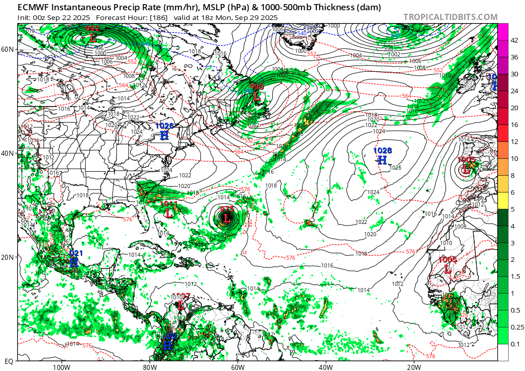
0z ECMWF: A cleanly tropical peak is 975 mb. (It gets down to 957 mb later, but with extratropical transition already started while doing a Fiona-esque slam into Nova Scotia.)

Image

12z ICON: Peak 951 mb.

Image

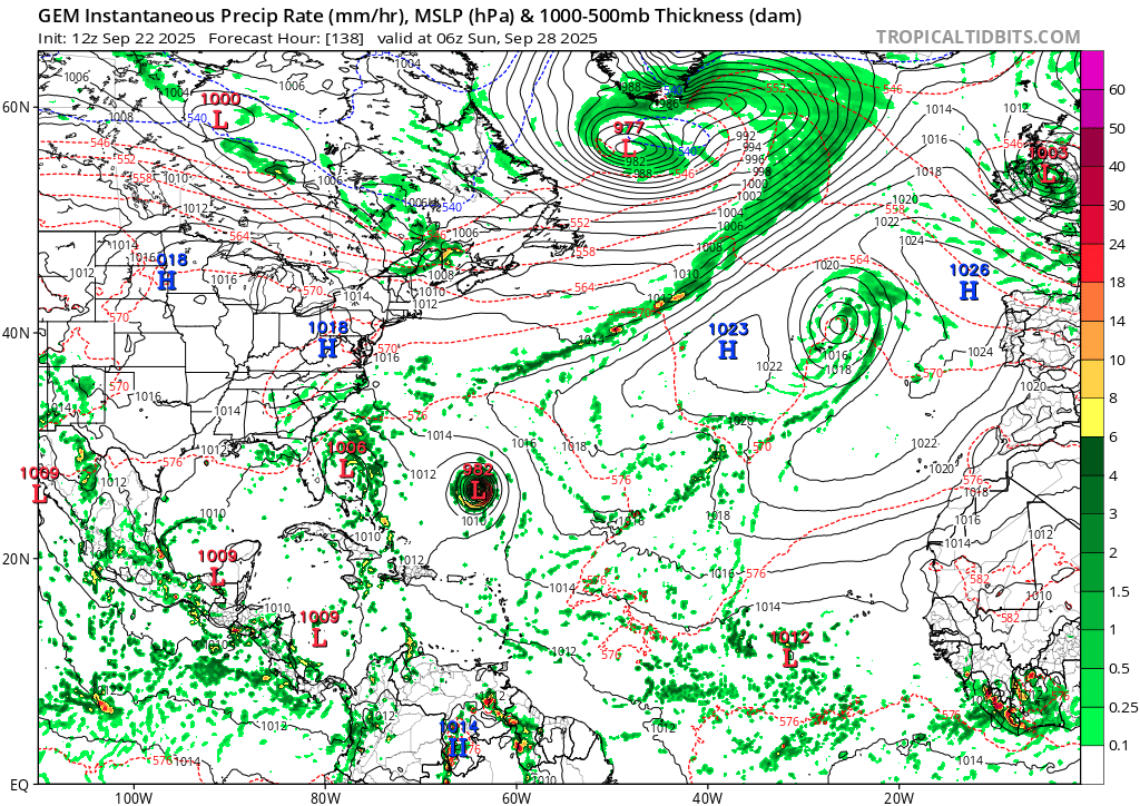
12z CMC: Peak 982 mb. (CMC pressures are usually very conservative - it shows Gabrielle as 994 mb now when it's actually in the 950s.)

Image

All three operational models have been developing this wave, with significant deepening in the subtropics, for a few runs now. GFS is the only one that lacks consistency, as it favors the 10/40 AOI to the west.
3 likes   

User avatar
cycloneye
Admin
Admin
Posts: 148479
Age: 69
Joined: Thu Oct 10, 2002 10:54 am
Location: San Juan, Puerto Rico

Re: Tropical Wave in the Central Atlantic (30/80)

#32 Postby cycloneye » Mon Sep 22, 2025 12:56 pm

2 PM.

Central Tropical Atlantic:
Shower and thunderstorm activity associated with a tropical wave
located about midway between the Lesser Antilles and the Cabo Verde
Islands continues to increase. Environmental conditions are
forecast to become more favorable for development by tomorrow,
and a tropical depression is likely to form on Wednesday or
Thursday while the system moves west-northwestward to
northwestward across the central Atlantic.
* Formation chance through 48 hours...low...30 percent.
* Formation chance through 7 days...high...80 percent
0 likes   
Visit the Caribbean-Central America Weather Thread where you can find at first post web cams,radars
and observations from Caribbean basin members Click Here

BobHarlem
Category 5
Category 5
Posts: 2566
Joined: Thu Oct 20, 2005 6:11 pm

Re: Tropical Wave in the Central Atlantic (30/80)

#33 Postby BobHarlem » Mon Sep 22, 2025 1:13 pm

12z Euro, over Bermuda as a 954mb major.

Image

(Also develops the other area as a landfall in NC as a TD/TS)
0 likes   

TomballEd
Category 5
Category 5
Posts: 1073
Age: 61
Joined: Wed Aug 16, 2023 4:52 pm
Location: Spring/Klein area, not Tomball

Re: Tropical Wave in the Central Atlantic (30/80)

#34 Postby TomballEd » Mon Sep 22, 2025 1:49 pm

Too close to each other? While the cherry looks better organized, the orange looks to be in a position to enhance shear on the cherry. Orange has farther to go to become a TC but it may stop the cherry from organizing all together.

Image
1 likes   

Sciencerocks
Category 5
Category 5
Posts: 10179
Age: 39
Joined: Thu Jul 06, 2017 1:51 am

Re: Tropical Wave in the Central Atlantic (30/80)

#35 Postby Sciencerocks » Mon Sep 22, 2025 2:08 pm

Image
2 likes   

User avatar
Teban54
Category 5
Category 5
Posts: 3761
Joined: Sat May 19, 2018 1:19 pm

Re: Tropical Wave in the Central Atlantic (30/80)

#36 Postby Teban54 » Mon Sep 22, 2025 2:10 pm


This actually shows the wave coming together nicely, more so than you would expect.
1 likes   

Pelicane
Tropical Storm
Tropical Storm
Posts: 190
Joined: Tue Sep 13, 2022 1:52 pm
Location: Lafayette, Louisiana

Re: Tropical Wave in the Central Atlantic (30/80)

#37 Postby Pelicane » Mon Sep 22, 2025 2:15 pm

Teban54 wrote:

This actually shows the wave coming together nicely, more so than you would expect.


The GFS is probably underestimating this wave. All of the models currently support it, even the AI models. Not sure why it's not seeing it.
0 likes   

User avatar
ScottNAtlanta
Category 5
Category 5
Posts: 2535
Joined: Sat May 25, 2013 3:11 pm
Location: Atlanta, GA

Re: Tropical Wave in the Central Atlantic (30/80)

#38 Postby ScottNAtlanta » Mon Sep 22, 2025 3:18 pm

Pelicane wrote:
Teban54 wrote:

This actually shows the wave coming together nicely, more so than you would expect.


The GFS is probably underestimating this wave. All of the models currently support it, even the AI models. Not sure why it's not seeing it.

On the other hand...the euro shear forecast would imply this wave should NOT develop. It has substantial shear in a couple of days over this while the western wave is shown to be in light shear, so I don't know why the euro wants to develop it. It seems like the 2 products are saying very different things
0 likes   
The posts in this forum are NOT official forecast and should not be used as such. They are just the opinion of the poster and may or may not be backed by sound meteorological data. They are NOT endorsed by any professional institution or storm2k.org. For official information, please refer to the NHC and NWS products.

User avatar
chaser1
S2K Supporter
S2K Supporter
Posts: 5761
Age: 64
Joined: Sat Oct 15, 2005 5:59 pm
Location: Longwood, Fl

Re: Tropical Wave in the Central Atlantic (20/70)

#39 Postby chaser1 » Mon Sep 22, 2025 3:56 pm

Teban54 wrote:I continue to be amazed at how quiet this thread is, given the intensities on many global models. Perhaps people have already season canceled?


I don't think the thread is quiet because most members are unaware of present activity. I think the quiet is primarily connected to lack of impact risk. Thus far this season we are primarily seeing a poleward recurvature storm track pattern in place. As we approach October its increasingly likely that additional Central Atlantic development will be apt to recurve as well. I doubt we'll see this board light up until a potential threat to the Caribbean, GOM, CONUS, or Canadian Seaboard occurs. That or, something else extraordinary.
0 likes   
Andy D

(For official information, please refer to the NHC and NWS products.)

User avatar
ConvergenceZone
Category 5
Category 5
Posts: 5240
Joined: Fri Jul 29, 2005 1:40 am
Location: Northern California

Re: Tropical Wave in the Central Atlantic (20/70)

#40 Postby ConvergenceZone » Mon Sep 22, 2025 4:01 pm

chaser1 wrote:
Teban54 wrote:I continue to be amazed at how quiet this thread is, given the intensities on many global models. Perhaps people have already season canceled?


I don't think the thread is quiet because most members are unaware of present activity. I think the quiet is primarily connected to lack of impact risk. Thus far this season we are primarily seeing a poleward recurvature storm track pattern in place. As we approach October its increasingly likely that additional Central Atlantic development will be apt to recurve as well. I doubt we'll see this board light up until a potential threat to the Caribbean, GOM, CONUS, or Canadian Seaboard occurs. That or, something else extraordinary.


I agree, out to sea storms don't usually interest most tropic enthusiasts here, thus the lack of posts. But of course we have to think of Bermuda at this point. Hopefully it will be in the clear.
1 likes   


Return to “Talkin' Tropics”

Who is online

Users browsing this forum: aspen, cycloneye, JoshwaDone and 69 guests