2025 Global Model Runs Discussion (Out thru day 16)

This is the general tropical discussion area. Anyone can take their shot at predicting a storms path.

Moderator: S2k Moderators

Forum rules

The posts in this forum are NOT official forecasts and should not be used as such. They are just the opinion of the poster and may or may not be backed by sound meteorological data. They are NOT endorsed by any professional institution or STORM2K. For official information, please refer to products from the National Hurricane Center and National Weather Service.

Help Support Storm2K
Message
Author
LAF92
Tropical Storm
Tropical Storm
Posts: 134
Joined: Fri Aug 18, 2023 6:27 pm

Re: 2025 Global Model Runs Discussion (Out thru day 16)

#1061 Postby LAF92 » Thu Sep 18, 2025 9:49 am

PTrackerLA wrote:
Weathertracker96 wrote:
PTrackerLA wrote:Just noticed the 06z Google model from weathernerds. Fairly robust signal emerges around 9/27...

https://i.imgur.com/krxEbIl.gif

https://i.imgur.com/xTwyTHf.jpeg


Did these models do ok with previous systems? I was just wondering as I’ve seen them posted in the before. The Caribbean may need to be watched soon


It's new this year and I haven't been following it that closely, but I remember it not being enthusiastic about 91L at all. We'll see if the GFS and EURO ensembles become more enthusiastic for by the end of the month.

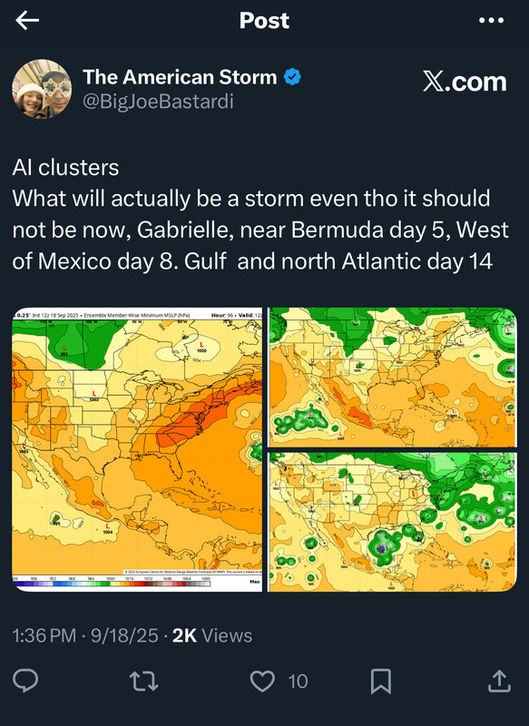
FWIW the 06z Euro AI has a system coming into the Gulf towards the end of September
0 likes   

TomballEd
Category 5
Category 5
Posts: 1031
Age: 61
Joined: Wed Aug 16, 2023 4:52 pm
Location: Spring/Klein area, not Tomball

Re: 2025 Global Model Runs Discussion (Out thru day 16)

#1062 Postby TomballEd » Thu Sep 18, 2025 9:56 am

PTrackerLA wrote:Just noticed the 06z Google model from weathernerds. Fairly robust signal emerges around 9/27...

https://i.imgur.com/krxEbIl.gif

https://i.imgur.com/xTwyTHf.jpeg


The Caribbean towards Gulf system doesn't show up on the Euro or GFS ensembles and until Google can show it out-predict the physics based ensembles, I disregard unless it has at least one model family's support.

6Z Euro, ok, it is pretty lonely, but the October 1949 Freeport Cat 2 crossed from the Pacific. Must have been either a cutoff low well S of where they usually settle or a strong negative tilt trough to do that. 0Z ensembles had one member which hits Louisiana as a 975 mb storm. I assume slop gyre genesis with the Pacific more likely to see a system than the Gulf.

Image
0 likes   

lsuhurricane
Category 1
Category 1
Posts: 270
Joined: Tue Aug 15, 2017 2:53 pm

Re: 2025 Global Model Runs Discussion (Out thru day 16)

#1063 Postby lsuhurricane » Thu Sep 18, 2025 11:05 am

The Caribbean towards Gulf system doesn't show up on the Euro or GFS ensembles


That's not completely accurate. Both GEFS and EPS indicate development in the exact same area at the 9-10 day mark. Very modest support, but it absolutely mirrors the AI output from both Euro AI and Google sets. Here's the latest output for reference.

Image

Image
5 likes   

Stratton23
Category 5
Category 5
Posts: 2809
Joined: Fri Jul 21, 2023 10:59 pm
Location: Katy, Tx

Re: 2025 Global Model Runs Discussion (Out thru day 16)

#1064 Postby Stratton23 » Thu Sep 18, 2025 4:26 pm

Watching the western gulf/ caribbean in the 8 -10 day range , things are starting to look a little bit interesting
2 likes   

TomballEd
Category 5
Category 5
Posts: 1031
Age: 61
Joined: Wed Aug 16, 2023 4:52 pm
Location: Spring/Klein area, not Tomball

Re: 2025 Global Model Runs Discussion (Out thru day 16)

#1065 Postby TomballEd » Thu Sep 18, 2025 4:50 pm

lsuhurricane wrote:
The Caribbean towards Gulf system doesn't show up on the Euro or GFS ensembles


That's not completely accurate. Both GEFS and EPS indicate development in the exact same area at the 9-10 day mark. Very modest support, but it absolutely mirrors the AI output from both Euro AI and Google sets. Here's the latest output for reference.

https://i.ibb.co/84gzZGSG/GEFS-Global-Cyclones-Caribbean-Ens-MSLP-Spaghettios.gif

https://i.ibb.co/hFkFxXB3/14-km-EPS-Global-Cyclones-Caribbean-Ens-MSLP-Spaghettios-3.gif


The few systems showing up on the GFS/Euro ensembles are generating over Central America, the BoC or Pacific. The Google ensembles have something developing in the Caribbean S of Jamaica/Cuba. Maybe the slop gyro extends that far out away from Central America but the much lower support for a CAG system from the physics ensembles suggests it is a moot point where any system that could enter the Gulf develops, because it probably won't.
0 likes   

User avatar
Travorum
Category 2
Category 2
Posts: 536
Joined: Tue Sep 05, 2023 9:36 am
Location: Dunedin, FL

Re: 2025 Global Model Runs Discussion (Out thru day 16)

#1066 Postby Travorum » Thu Sep 18, 2025 5:21 pm

TomballEd wrote:
lsuhurricane wrote:
The Caribbean towards Gulf system doesn't show up on the Euro or GFS ensembles


That's not completely accurate. Both GEFS and EPS indicate development in the exact same area at the 9-10 day mark. Very modest support, but it absolutely mirrors the AI output from both Euro AI and Google sets. Here's the latest output for reference.

https://i.ibb.co/84gzZGSG/GEFS-Global-Cyclones-Caribbean-Ens-MSLP-Spaghettios.gif

https://i.ibb.co/hFkFxXB3/14-km-EPS-Global-Cyclones-Caribbean-Ens-MSLP-Spaghettios-3.gif


The few systems showing up on the GFS/Euro ensembles are generating over Central America, the BoC or Pacific. The Google ensembles have something developing in the Caribbean S of Jamaica/Cuba. Maybe the slop gyro extends that far out away from Central America but the much lower support for a CAG system from the physics ensembles suggests it is a moot point where any system that could enter the Gulf develops, because it probably won't.


I mean, it is true that the physics models show a low amount of support for a system considering how far out they're showing development, some ensemble members that do develop on them originate from the Caribbean south of Cuba. The physics models also try to spin up something in the BoC and off the coast of Belize which I'm guessing is what you're talking about. Here's the Deep Mind vs. GEFS ensembles:


Deep Mind:GEFS:
ImageImage


I can't get the Euro ensembles out to 360hrs for free (i.e. weathernerds isn't going to show it because the members that develop are 300+ hrs out), but the gif lsuhurricane posted shows a similar pattern of development that the GEFS shows. It also looks like out to 384hrs the GEFS develops another member or two. So, both the AI and physics models show some development in the SW Caribbean, its just that the physics model signal is very small (to the point I put little weight in it for now—just watch and see).
2 likes   

LAF92
Tropical Storm
Tropical Storm
Posts: 134
Joined: Fri Aug 18, 2023 6:27 pm

Re: 2025 Global Model Runs Discussion (Out thru day 16)

#1067 Postby LAF92 » Thu Sep 18, 2025 5:47 pm

Stratton23 wrote:Watching the western gulf/ caribbean in the 8 -10 day range , things are starting to look a little bit interesting

Image
1 likes   

User avatar
cainjamin
Tropical Storm
Tropical Storm
Posts: 172
Age: 34
Joined: Mon Apr 17, 2017 1:38 pm
Location: Nova Scotia, Canada

Re: 2025 Global Model Runs Discussion (Out thru day 16)

#1068 Postby cainjamin » Thu Sep 18, 2025 6:23 pm

Yes, the DeepMind models are quite keen on a strong storm in the WCar/GoM in the 9-12 day period where the GFS/ECMWF aren't as interested. It will be interesting to see what happens over the next few days as the AI models correctly forecast 91L much moreso than the regular models.
3 likes   
Noel '07, Kyle '08, Earl '10, Arthur '14, Dorian '19, Teddy '20, Lee '23

zzzh
Category 4
Category 4
Posts: 940
Joined: Thu Sep 02, 2021 1:13 pm

Re: 2025 Global Model Runs Discussion (Out thru day 16)

#1069 Postby zzzh » Thu Sep 18, 2025 7:44 pm

Image
Recent FNV3 runs generally show 3 systems: the wave behind Gabrielle develops near 60W at around day 7, the west Caribbean system around day 9 and another wave in the MDR around day 12.
4 likes   

User avatar
N2FSU
S2K Supporter
S2K Supporter
Posts: 1068
Joined: Thu Sep 04, 2003 2:04 pm
Location: Tallahassee, FL

Re: 2025 Global Model Runs Discussion (Out thru day 16)

#1070 Postby N2FSU » Fri Sep 19, 2025 5:03 am

0z Euro:

Image

Image


Sent from my iPad using Tapatalk
2 likes   

zzzh
Category 4
Category 4
Posts: 940
Joined: Thu Sep 02, 2021 1:13 pm

Re: 2025 Global Model Runs Discussion (Out thru day 16)

#1071 Postby zzzh » Fri Sep 19, 2025 6:30 am

zzzh wrote:https://i.imgur.com/o5iAqY3.png
Recent FNV3 runs generally show 3 systems: the wave behind Gabrielle develops near 60W at around day 7, the west Caribbean system around day 9 and another wave in the MDR around day 12.

00Z FNV3 continues to show this, and I think the Caribbean system is actually the 10/20 wave a few days ago.
0 likes   

TomballEd
Category 5
Category 5
Posts: 1031
Age: 61
Joined: Wed Aug 16, 2023 4:52 pm
Location: Spring/Klein area, not Tomball

Re: 2025 Global Model Runs Discussion (Out thru day 16)

#1072 Postby TomballEd » Fri Sep 19, 2025 8:27 am

Travorum wrote:
TomballEd wrote:
lsuhurricane wrote:
That's not completely accurate. Both GEFS and EPS indicate development in the exact same area at the 9-10 day mark. Very modest support, but it absolutely mirrors the AI output from both Euro AI and Google sets. Here's the latest output for reference.

https://i.ibb.co/84gzZGSG/GEFS-Global-Cyclones-Caribbean-Ens-MSLP-Spaghettios.gif

https://i.ibb.co/hFkFxXB3/14-km-EPS-Global-Cyclones-Caribbean-Ens-MSLP-Spaghettios-3.gif


The few systems showing up on the GFS/Euro ensembles are generating over Central America, the BoC or Pacific. The Google ensembles have something developing in the Caribbean S of Jamaica/Cuba. Maybe the slop gyro extends that far out away from Central America but the much lower support for a CAG system from the physics ensembles suggests it is a moot point where any system that could enter the Gulf develops, because it probably won't.


I mean, it is true that the physics models show a low amount of support for a system considering how far out they're showing development, some ensemble members that do develop on them originate from the Caribbean south of Cuba. The physics models also try to spin up something in the BoC and off the coast of Belize which I'm guessing is what you're talking about. Here's the Deep Mind vs. GEFS ensembles:


Deep Mind:GEFS:
https://i.imgur.com/ERlDdom.pnghttps://i.imgur.com/zrcs3nq.png


I can't get the Euro ensembles out to 360hrs for free (i.e. weathernerds isn't going to show it because the members that develop are 300+ hrs out), but the gif lsuhurricane posted shows a similar pattern of development that the GEFS shows. It also looks like out to 384hrs the GEFS develops another member or two. So, both the AI and physics models show some development in the SW Caribbean, its just that the physics model signal is very small (to the point I put little weight in it for now—just watch and see).


You can see the few GFS/Euro ensembles members that have a system in the Gulf develop it in the SW Caribbean, BoC or Pacific, the AI ensembles are developing something in the Caribbean. They are showing 2 different ways to get a storm in the Gulf. Op Euro (and to a lesser extent develop a wave from the east just north of the Greater Antilles beyond 240 hours, GFS is meh but Euro at 360 has a potent low S of MS/AL/FL starting to make the turn northward beyond the STR. The op models may be indirectly supporting the Google ensembles of a wave developing in the Caribbean. My gut, nothing will be in the Gulf or W Caribbean in 2 weeks. 15 days is silly range where the op is no better than any ensemble member.
Image

Oh, free Euro ensembles to 360 hours
Image
1 likes   

caneman
Category 5
Category 5
Posts: 1473
Joined: Fri Sep 05, 2014 5:44 am
Location: Clearwater Beach, Fl

Re: 2025 Global Model Runs Discussion (Out thru day 16)

#1073 Postby caneman » Fri Sep 19, 2025 8:48 am

TomballEd wrote:
Travorum wrote:
TomballEd wrote:
The few systems showing up on the GFS/Euro ensembles are generating over Central America, the BoC or Pacific. The Google ensembles have something developing in the Caribbean S of Jamaica/Cuba. Maybe the slop gyro extends that far out away from Central America but the much lower support for a CAG system from the physics ensembles suggests it is a moot point where any system that could enter the Gulf develops, because it probably won't.


I mean, it is true that the physics models show a low amount of support for a system considering how far out they're showing development, some ensemble members that do develop on them originate from the Caribbean south of Cuba. The physics models also try to spin up something in the BoC and off the coast of Belize which I'm guessing is what you're talking about. Here's the Deep Mind vs. GEFS ensembles:


Deep Mind:GEFS:
https://i.imgur.com/ERlDdom.pnghttps://i.imgur.com/zrcs3nq.png


I can't get the Euro ensembles out to 360hrs for free (i.e. weathernerds isn't going to show it because the members that develop are 300+ hrs out), but the gif lsuhurricane posted shows a similar pattern of development that the GEFS shows. It also looks like out to 384hrs the GEFS develops another member or two. So, both the AI and physics models show some development in the SW Caribbean, its just that the physics model signal is very small (to the point I put little weight in it for now—just watch and see).


You can see the few GFS/Euro ensembles members that have a system in the Gulf develop it in the SW Caribbean, BoC or Pacific, the AI ensembles are developing something in the Caribbean. They are showing 2 different ways to get a storm in the Gulf. Op Euro (and to a lesser extent develop a wave from the east just north of the Greater Antilles beyond 240 hours, GFS is meh but Euro at 360 has a potent low S of MS/AL/FL starting to make the turn northward beyond the STR. The op models may be indirectly supporting the Google ensembles of a wave developing in the Caribbean. My gut, nothing will be in the Gulf or W Caribbean in 2 weeks. 15 days is silly range where the op is no better than any ensemble member.
https://i.imgur.com/gewzvd2.png

Oh, free Euro ensembles to 360 hours
https://i.imgur.com/0VOqmlb.png


Regardless of what the long range models are showing, I believe there will be something in the gulf. In fact, I would bet on 2 or even 3 before end season
0 likes   

Weathertracker96
Tropical Storm
Tropical Storm
Posts: 145
Joined: Mon Oct 16, 2023 3:41 pm

Re: 2025 Global Model Runs Discussion (Out thru day 16)

#1074 Postby Weathertracker96 » Fri Sep 19, 2025 9:21 am

caneman wrote:
TomballEd wrote:
Travorum wrote:
I mean, it is true that the physics models show a low amount of support for a system considering how far out they're showing development, some ensemble members that do develop on them originate from the Caribbean south of Cuba. The physics models also try to spin up something in the BoC and off the coast of Belize which I'm guessing is what you're talking about. Here's the Deep Mind vs. GEFS ensembles:


Deep Mind:GEFS:
https://i.imgur.com/ERlDdom.pnghttps://i.imgur.com/zrcs3nq.png


I can't get the Euro ensembles out to 360hrs for free (i.e. weathernerds isn't going to show it because the members that develop are 300+ hrs out), but the gif lsuhurricane posted shows a similar pattern of development that the GEFS shows. It also looks like out to 384hrs the GEFS develops another member or two. So, both the AI and physics models show some development in the SW Caribbean, its just that the physics model signal is very small (to the point I put little weight in it for now—just watch and see).


You can see the few GFS/Euro ensembles members that have a system in the Gulf develop it in the SW Caribbean, BoC or Pacific, the AI ensembles are developing something in the Caribbean. They are showing 2 different ways to get a storm in the Gulf. Op Euro (and to a lesser extent develop a wave from the east just north of the Greater Antilles beyond 240 hours, GFS is meh but Euro at 360 has a potent low S of MS/AL/FL starting to make the turn northward beyond the STR. The op models may be indirectly supporting the Google ensembles of a wave developing in the Caribbean. My gut, nothing will be in the Gulf or W Caribbean in 2 weeks. 15 days is silly range where the op is no better than any ensemble member.
https://i.imgur.com/gewzvd2.png

Oh, free Euro ensembles to 360 hours
https://i.imgur.com/0VOqmlb.png


Regardless of what the long range models are showing, I believe there will be something in the gulf. In fact, I would bet on 2 or even 3 before end season


I agree with you caneman. The gulf and Caribbean should be watched for sure. The season is not over yet.
1 likes   

TomballEd
Category 5
Category 5
Posts: 1031
Age: 61
Joined: Wed Aug 16, 2023 4:52 pm
Location: Spring/Klein area, not Tomball

Re: 2025 Global Model Runs Discussion (Out thru day 16)

#1075 Postby TomballEd » Fri Sep 19, 2025 9:48 am

caneman wrote:
TomballEd wrote:
Travorum wrote:
I mean, it is true that the physics models show a low amount of support for a system considering how far out they're showing development, some ensemble members that do develop on them originate from the Caribbean south of Cuba. The physics models also try to spin up something in the BoC and off the coast of Belize which I'm guessing is what you're talking about. Here's the Deep Mind vs. GEFS ensembles:


Deep Mind:GEFS:
https://i.imgur.com/ERlDdom.pnghttps://i.imgur.com/zrcs3nq.png


I can't get the Euro ensembles out to 360hrs for free (i.e. weathernerds isn't going to show it because the members that develop are 300+ hrs out), but the gif lsuhurricane posted shows a similar pattern of development that the GEFS shows. It also looks like out to 384hrs the GEFS develops another member or two. So, both the AI and physics models show some development in the SW Caribbean, its just that the physics model signal is very small (to the point I put little weight in it for now—just watch and see).


You can see the few GFS/Euro ensembles members that have a system in the Gulf develop it in the SW Caribbean, BoC or Pacific, the AI ensembles are developing something in the Caribbean. They are showing 2 different ways to get a storm in the Gulf. Op Euro (and to a lesser extent develop a wave from the east just north of the Greater Antilles beyond 240 hours, GFS is meh but Euro at 360 has a potent low S of MS/AL/FL starting to make the turn northward beyond the STR. The op models may be indirectly supporting the Google ensembles of a wave developing in the Caribbean. My gut, nothing will be in the Gulf or W Caribbean in 2 weeks. 15 days is silly range where the op is no better than any ensemble member.
https://i.imgur.com/gewzvd2.png

Oh, free Euro ensembles to 360 hours
https://i.imgur.com/0VOqmlb.png


Regardless of what the long range models are showing, I believe there will be something in the gulf. In fact, I would bet on 2 or even 3 before end season


I'm starting to think 2 or 3 Gulf systems is a smidge high but I'm sure they'll be one in or near Florida in October simply because of the past few years.
2 likes   

User avatar
SFLcane
S2K Supporter
S2K Supporter
Posts: 10225
Age: 47
Joined: Sat Jun 05, 2010 1:44 pm
Location: Lake Worth Florida

Re: 2025 Global Model Runs Discussion (Out thru day 16)

#1076 Postby SFLcane » Fri Sep 19, 2025 11:20 am

Its accuweather i get it but this makes good sense to me. Watch that


Link: https://youtube.com/watch?v=Mp_1e35d9Jc
2 likes   

Stratton23
Category 5
Category 5
Posts: 2809
Joined: Fri Jul 21, 2023 10:59 pm
Location: Katy, Tx

Re: 2025 Global Model Runs Discussion (Out thru day 16)

#1077 Postby Stratton23 » Fri Sep 19, 2025 11:44 am

GFS caving to the Euro AIFS, weak TS moving in between the florida straits, AIFS gets a lot more weight since it has done pretty good with the last several systems and showing no development, now that its showing more consistently with developing this one, it deserves to be watched closely
3 likes   

User avatar
SFLcane
S2K Supporter
S2K Supporter
Posts: 10225
Age: 47
Joined: Sat Jun 05, 2010 1:44 pm
Location: Lake Worth Florida

Re: 2025 Global Model Runs Discussion (Out thru day 16)

#1078 Postby SFLcane » Fri Sep 19, 2025 11:59 am

Stratton23 wrote:GFS caving to the Euro AIFS, weak TS moving in between the florida straits, AIFS gets a lot more weight since it has done pretty good with the last several systems and showing no development, now that its showing more consistently with developing this one, it deserves to be watched closely


Dont think you'll have twin tc's of the keys but the fact its showing something in the same area as Ai as you mentioned it deserves some weight. Well see
0 likes   

Pelicane
Tropical Storm
Tropical Storm
Posts: 176
Joined: Tue Sep 13, 2022 1:52 pm
Location: Lafayette, Louisiana

Re: 2025 Global Model Runs Discussion (Out thru day 16)

#1079 Postby Pelicane » Fri Sep 19, 2025 12:05 pm

The left-most entity seems to come from the ULL currently to Gabrielle's west. As it dips south it interacts with tropical moisture near Hispaniola and that interaction forms a LLC north of the island, which strengthens due to a favourable upper-level pattern. The second entitity is the yellow lemon, I believe.
0 likes   

User avatar
SFLcane
S2K Supporter
S2K Supporter
Posts: 10225
Age: 47
Joined: Sat Jun 05, 2010 1:44 pm
Location: Lake Worth Florida

Re: 2025 Global Model Runs Discussion (Out thru day 16)

#1080 Postby SFLcane » Fri Sep 19, 2025 1:03 pm

Euro has crickets after Gabrielle into the first wk of Oct.
0 likes   


Return to “Talkin' Tropics”

Who is online

Users browsing this forum: cheezyWXguy, cycloneye, Fancy1002, IsabelaWeather, prairie2, wileytheartist and 133 guests