Tropical Wave over the Central Atlantic (Is Invest 92L)
Moderator: S2k Moderators
Forum rules

The posts in this forum are NOT official forecasts and should not be used as such. They are just the opinion of the poster and may or may not be backed by sound meteorological data. They are NOT endorsed by any professional institution or STORM2K. For official information, please refer to products from the National Hurricane Center and National Weather Service.
-
floridasun
- Tropical Storm

- Posts: 245
- Joined: Tue Sep 14, 2021 3:59 pm
Re: Tropical Wave near the Cabo Verde Islands (0/60)
nhc have this nw after moving wnw let see that change
0 likes

Re: Tropical Wave near the Cabo Verde Islands (0/60)
floridasun wrote:nhc have this nw after moving wnw let see that change
When the NHC advisory says: "a tropical
depression could form by the middle to latter part of next week
while moving west-northwestward to northwestward at 10 to 15 mph"
I don't think that means first WNW, then NW
It just means a heading somewhere between WNW and NW without any sequence implied.
2 likes

Re: Tropical Wave near the Cabo Verde Islands (0/60)
0Z UKMET: TS in middle of ocean again
NEW TROPICAL CYCLONE FORECAST TO DEVELOP AFTER 96 HOURS
FORECAST POSITION AT T+ 96 : 16.4N 45.5W
LEAD CENTRAL MAXIMUM WIND
VERIFYING TIME TIME POSITION PRESSURE (MB) SPEED (KNOTS)
-------------- ---- -------- ------------- -------------
1200UTC 17.09.2025 96 16.4N 45.5W 1005 41
0000UTC 18.09.2025 108 17.6N 47.7W 1005 45
1200UTC 18.09.2025 120 19.7N 49.9W 1006 44
0000UTC 19.09.2025 132 20.6N 51.6W 1006 40
1200UTC 19.09.2025 144 21.4N 53.0W 1005 36
0000UTC 20.09.2025 156 22.5N 53.5W 1004 46
1200UTC 20.09.2025 168 22.9N 55.4W 1002 45
0 likes
Personal Forecast Disclaimer:
The posts in this forum are NOT official forecasts and should not be used as such. They are just the opinion of the poster and may or may not be backed by sound meteorological data. They are NOT endorsed by any professional institution or storm2k.org. For official information, please refer to the NHC and NWS products.
The posts in this forum are NOT official forecasts and should not be used as such. They are just the opinion of the poster and may or may not be backed by sound meteorological data. They are NOT endorsed by any professional institution or storm2k.org. For official information, please refer to the NHC and NWS products.
-
AJC3

- Admin

- Posts: 4156
- Age: 62
- Joined: Tue Aug 31, 2004 7:04 pm
- Location: Ballston Spa, New York
- Contact:
Re: Tropical Wave over the Eastern Atlantic (0/60)
Tropical Weather Outlook
NWS National Hurricane Center Miami FL
200 AM EDT Sun Sep 14 2025
For the North Atlantic...Caribbean Sea and the Gulf of America:
Eastern and Central Tropical Atlantic:
A tropical wave over the eastern tropical Atlantic is producing a
large area of disorganized showers and thunderstorms. Although dry
and stable air is expected to limit development during the next
couple of days, some gradual organization is possible thereafter,
and a tropical depression could form during the middle to latter
part of next week as the system moves west-northwestward to
northwestward at 10 to 15 mph over the central tropical Atlantic.
* Formation chance through 48 hours...low...near 0 percent.
* Formation chance through 7 days...medium...60 percent.
0 likes
-
cycloneye

- Admin
- Posts: 149682
- Age: 69
- Joined: Thu Oct 10, 2002 10:54 am
- Location: San Juan, Puerto Rico
Re: Tropical Wave over the Eastern Atlantic (10/70)
Tropical Weather Outlook
NWS National Hurricane Center Miami FL
800 AM EDT Sun Sep 14 2025
For the North Atlantic...Caribbean Sea and the Gulf of America:
Eastern and Central Tropical Atlantic:
A tropical wave over the eastern tropical Atlantic is producing a
large area of disorganized showers and thunderstorms. Although dry
and stable air is expected to limit development during the next
couple of days, gradual development is anticipated thereafter, and a
tropical depression is likely to form during the middle to latter
part of this week as the system moves west-northwestward at 10 to 15
mph over the central tropical Atlantic.
* Formation chance through 48 hours...low...10 percent.
* Formation chance through 7 days...high...70 percent.
$$
Forecaster Hagen

0 likes
Visit the Caribbean-Central America Weather Thread where you can find at first post web cams,radars
and observations from Caribbean basin members Click Here
and observations from Caribbean basin members Click Here

Re: Tropical Wave over the Eastern Atlantic (10/70)
Definitely a stronger signal from all models today. Consensus is slow development at first, remaining a TD/weak TS until north of the leewards. Conditions look better there— the GFS and Euro both have a MH recurving. Bermuda possibly in play.
0 likes
Igor 2010, Sandy 2012, Fay 2014, Gonzalo 2014, Joaquin 2015, Nicole 2016, Humberto 2019, Imelda 2025
I am only a tropical weather enthusiast. My predictions are not official and may or may not be backed by sound meteorological data. For official information, please refer to the NHC and NWS products.
I am only a tropical weather enthusiast. My predictions are not official and may or may not be backed by sound meteorological data. For official information, please refer to the NHC and NWS products.
-
TomballEd
- Category 5

- Posts: 1317
- Age: 62
- Joined: Wed Aug 16, 2023 4:52 pm
- Location: Spring/Klein area, not Tomball
Re: Tropical Wave over the Eastern Atlantic (10/70)
GFS and Euro both suggest the next system will not become strong until it reaches the subtropics.
0 likes
-
MEANINGLESS_NUMBERS
- Category 2

- Posts: 503
- Joined: Mon Nov 02, 2020 1:43 pm
Re: Tropical Wave over the Eastern Atlantic (10/70)
0z Euro directly hits Bermuda at 947 mbar. That's probably high Cat 3.
0 likes
Emily '87, Felix '95, Gert '99, Fabian '03, Humberto '19, Paulette '20, Teddy '20, Fiona '22, Lee '23, Ernesto '24, Humberto/Imelda '25
Re: Tropical Wave over the Eastern Atlantic (10/70)
12Z:
-JMA has this as a TD at 48 and a TS at 72. This is stronger than the two prior 12Z runs that each had it as only a TD.
-**Edit: Euro has a MH passing just SE of Bermuda
-UKMET again has this as a TS. This is a bit further W than recent runs but it’s still aiming a bit E of Bermuda as of 168:
-JMA has this as a TD at 48 and a TS at 72. This is stronger than the two prior 12Z runs that each had it as only a TD.
-**Edit: Euro has a MH passing just SE of Bermuda
-UKMET again has this as a TS. This is a bit further W than recent runs but it’s still aiming a bit E of Bermuda as of 168:
NEW TROPICAL CYCLONE FORECAST TO DEVELOP AFTER 72 HOURS
FORECAST POSITION AT T+ 72 : 16.4N 47.4W
LEAD CENTRAL MAXIMUM WIND
VERIFYING TIME TIME POSITION PRESSURE (MB) SPEED (KNOTS)
-------------- ---- -------- ------------- -------------
1200UTC 17.09.2025 72 16.4N 47.4W 1006 40
0000UTC 18.09.2025 84 17.7N 48.8W 1006 42
1200UTC 18.09.2025 96 19.5N 52.1W 1006 44
0000UTC 19.09.2025 108 20.6N 54.3W 1006 40
1200UTC 19.09.2025 120 22.8N 55.1W 1006 44
0000UTC 20.09.2025 132 23.1N 57.0W 1005 43
1200UTC 20.09.2025 144 25.1N 57.7W 1003 46
0000UTC 21.09.2025 156 26.3N 58.6W 1001 49
1200UTC 21.09.2025 168 28.3N 59.3W 999 48
Last edited by LarryWx on Sun Sep 14, 2025 1:17 pm, edited 1 time in total.
0 likes
Personal Forecast Disclaimer:
The posts in this forum are NOT official forecasts and should not be used as such. They are just the opinion of the poster and may or may not be backed by sound meteorological data. They are NOT endorsed by any professional institution or storm2k.org. For official information, please refer to the NHC and NWS products.
The posts in this forum are NOT official forecasts and should not be used as such. They are just the opinion of the poster and may or may not be backed by sound meteorological data. They are NOT endorsed by any professional institution or storm2k.org. For official information, please refer to the NHC and NWS products.
-
StormWeather

- Category 1

- Posts: 477
- Joined: Wed Jun 05, 2024 2:34 pm
Re: Tropical Wave over the Eastern Atlantic (20/70)
20/70 now
ZCZC MIATWOAT ALL
TTAA00 KNHC DDHHMM
Tropical Weather Outlook
NWS National Hurricane Center Miami FL
200 PM EDT Sun Sep 14 2025
For the North Atlantic...Caribbean Sea and the Gulf of America:
1. Eastern and Central Tropical Atlantic:
A tropical wave over the eastern tropical Atlantic is producing a
large area of disorganized showers and thunderstorms. Although dry
and stable air is expected to limit development during the next day
or so, gradual development is anticipated thereafter, and a tropical
depression is likely to form during the middle to latter part of
this week as the system moves west-northwestward at 10 to 15 mph
over the central tropical Atlantic.
* Formation chance through 48 hours...low...20 percent.
* Formation chance through 7 days...high...70 percent.
Forecaster Hagen
0 likes
Just an average cyclone tracker
The posts in this forum are NOT official forecasts and should not be used as such. They are just the opinion of the poster and may or may not be backed by sound meteorological data. They are NOT endorsed by any professional institution or storm2k.org. For official information, please refer to the NHC and NWS products
The posts in this forum are NOT official forecasts and should not be used as such. They are just the opinion of the poster and may or may not be backed by sound meteorological data. They are NOT endorsed by any professional institution or storm2k.org. For official information, please refer to the NHC and NWS products

Re: Tropical Wave over the Eastern Atlantic (20/70)
Still a broad area of low pressure near the CV islands circulation center expected to close off in a couple days.
We don't know that latitude they will call it yet but the models haven't any tracks through the Caribbean Hebert box so far. Whats everybody's Bermuda wish cast?
We don't know that latitude they will call it yet but the models haven't any tracks through the Caribbean Hebert box so far. Whats everybody's Bermuda wish cast?
0 likes
-
TomballEd
- Category 5
- Posts: 1317
- Age: 62
- Joined: Wed Aug 16, 2023 4:52 pm
- Location: Spring/Klein area, not Tomball
Re: Tropical Wave over the Eastern Atlantic (20/70)
Nimbus wrote:Still a broad area of low pressure near the CV islands circulation center expected to close off in a couple days.
We don't know that latitude they will call it yet but the models haven't any tracks through the Caribbean Hebert box so far. Whats everybody's Bermuda wish cast?
I'm still a little Lucy and the football after the last few invests, but 100 miles nearest approach (misses east) to Bermuda at 950 mb. Low level vort is S of the deepest convection.
0 likes
Re: Tropical Wave over the Eastern Atlantic (20/70)
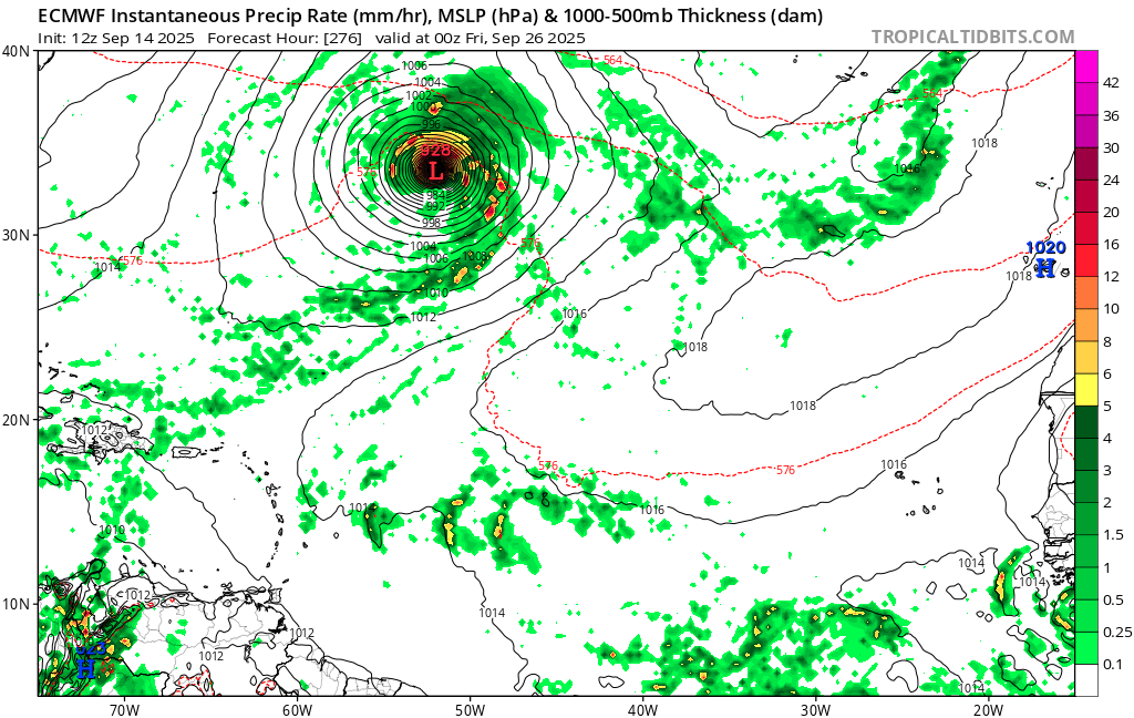
12z Euro gets it down to an insane 928mb on its way out. Fiona of the central Atlantic.
2 likes
Igor 2010, Sandy 2012, Fay 2014, Gonzalo 2014, Joaquin 2015, Nicole 2016, Humberto 2019, Imelda 2025
I am only a tropical weather enthusiast. My predictions are not official and may or may not be backed by sound meteorological data. For official information, please refer to the NHC and NWS products.
I am only a tropical weather enthusiast. My predictions are not official and may or may not be backed by sound meteorological data. For official information, please refer to the NHC and NWS products.

-
DorkyMcDorkface

- Category 5
- Posts: 1038
- Age: 28
- Joined: Mon Sep 30, 2019 1:32 pm
- Location: Mid-Atlantic
Re: Tropical Wave over the Eastern Atlantic (20/70)
Kazmit wrote:12z Euro gets it down to an insane 928mb on its way out. Fiona of the central Atlantic.
https://i.postimg.cc/3JNSCqvC/ecmwf-mslp-pcpn-eatl-70.png
GFS and CMC aren't quite as aggressive but they do show this blowing up in the subtropics eventually as well.


1 likes
Please note the thoughts expressed by this account are solely those of the user and are from a hobbyist perspective. For more comprehensive analysis, consult an actual professional meteorologist or meteorological agency.
Floyd 1999 | Isabel 2003 | Hanna 2008 | Irene 2011 | Sandy 2012 | Isaias 2020
-
cycloneye
- Admin
- Posts: 149682
- Age: 69
- Joined: Thu Oct 10, 2002 10:54 am
- Location: San Juan, Puerto Rico
Re: Tropical Wave over the Eastern Atlantic (20/70)
Tropical Weather Outlook
NWS National Hurricane Center Miami FL
800 PM EDT Sun Sep 14 2025
For the North Atlantic...Caribbean Sea and the Gulf of America:
1. Eastern and Central Tropical Atlantic:
A tropical wave over the eastern tropical Atlantic is producing a
large area of disorganized showers and thunderstorms. Although dry
and stable air is expected to limit development during the next day
or so, gradual development is anticipated thereafter, and a tropical
depression is likely to form during the middle to latter part of
this week as the system moves west-northwestward at 10 to 15 mph
over the central tropical Atlantic.
* Formation chance through 48 hours...low...20 percent.
* Formation chance through 7 days...high...70 percent.
Forecaster Mahoney/Bucci/Pasch
0 likes
Visit the Caribbean-Central America Weather Thread where you can find at first post web cams,radars
and observations from Caribbean basin members Click Here
and observations from Caribbean basin members Click Here
Re: Tropical Wave over the Eastern Atlantic (20/70)
GEFS shifted quite a bit SW. A lot of Jouquin like U tracks.
0 likes
-
cycloneye
- Admin
- Posts: 149682
- Age: 69
- Joined: Thu Oct 10, 2002 10:54 am
- Location: San Juan, Puerto Rico
Re: Tropical Wave over the Eastern Atlantic (20/70)
Still some work to do in the organization as there are two spins, one north and the other more south.

1 likes
Visit the Caribbean-Central America Weather Thread where you can find at first post web cams,radars
and observations from Caribbean basin members Click Here
and observations from Caribbean basin members Click Here
Re: Tropical Wave over the Eastern Atlantic (20/70)
If this fails to become a TD……..
0 likes
Personal Forecast Disclaimer:
The posts in this forum are NOT official forecasts and should not be used as such. They are just the opinion of the poster and may or may not be backed by sound meteorological data. They are NOT endorsed by any professional institution or storm2k.org. For official information, please refer to the NHC and NWS products.
The posts in this forum are NOT official forecasts and should not be used as such. They are just the opinion of the poster and may or may not be backed by sound meteorological data. They are NOT endorsed by any professional institution or storm2k.org. For official information, please refer to the NHC and NWS products.
Who is online
Users browsing this forum: No registered users and 179 guests