Even the GFS ensembles have more Pacific systems. Much too early to get concerned but Euro just N of Caribbean threat in 2 weeks seems more likely.
May have two MDR systems in next two weeks.
2025 Global Model Runs Discussion (Out thru day 16)
Moderator: S2k Moderators
Forum rules

The posts in this forum are NOT official forecasts and should not be used as such. They are just the opinion of the poster and may or may not be backed by sound meteorological data. They are NOT endorsed by any professional institution or STORM2K. For official information, please refer to products from the National Hurricane Center and National Weather Service.
-
DunedinDave
- Category 1

- Posts: 269
- Joined: Fri Aug 25, 2023 10:31 am
Re: 2025 Global Model Runs Discussion (Out thru day 16)
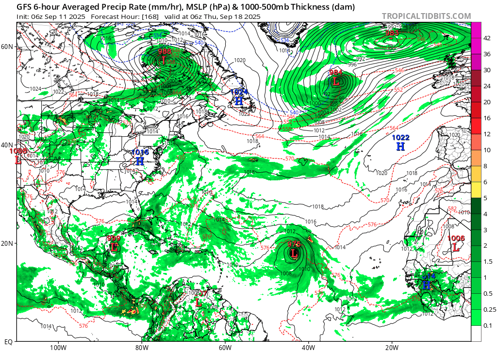
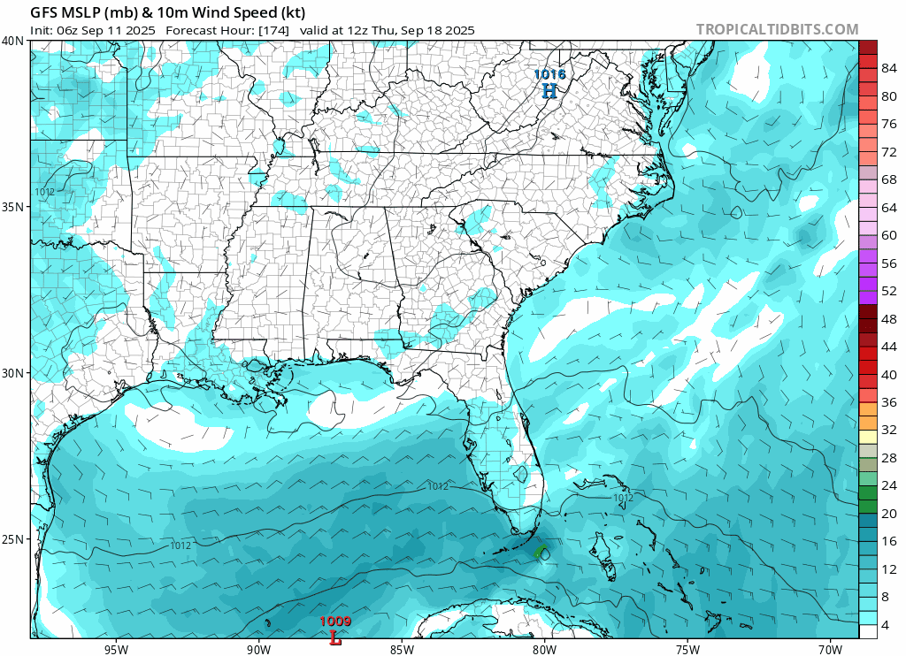
BobHarlem wrote:6z GFS with another "Perrycane". Big Bend cannot catch a break if this verifies. (no other operational model has it, so it's probably phantom, even a week out, it's already shifted back in time from Monday runs that were showing the gulf which are a telltale sign of phantom CAG.)
https://i.postimg.cc/fyykFrmZ/gfs-mslp-wind-seus-fh174-336.gif
As I said in another post, it’s almost the exact same track on almost the exact same day that Helene hit last year.
That said, I’m not buying it yet. GFS has Brownsville at 0z and Perry at 6z. It’s all over the place. No other models really showing much at least in the next week. I think if something forms it’s more likely to head into Mexico or the Yucatán and cross into the Pacific.
1 likes

Re: 2025 Global Model Runs Discussion (Out thru day 16)
0z ECMWF and 6z GFS both have a second MDR hurricane behind the 0/30 AOI, from a wave that emerges from Africa around Sep 20. Gets much closer to the islands, although obviously too early to be a serious concern especially for CONUS.
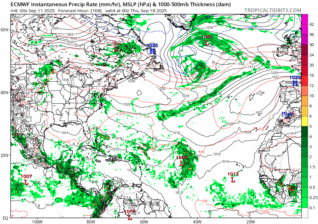
1 likes
TC naming lists: retirements and intensity
Most aggressive Advisory #1's in North Atlantic (cr. kevin for starting the list)
Most aggressive Advisory #1's in North Atlantic (cr. kevin for starting the list)
-
Stratton23
- Category 5

- Posts: 3477
- Joined: Fri Jul 21, 2023 10:59 pm
- Location: Katy, Tx
Re: 2025 Global Model Runs Discussion (Out thru day 16)
CMC caved to the GFS with a CAG system lifting due north out of the SW caribbean so wont be surprised when a lemon is issued for the NW caribbean in a couple of days, both models are also showing 3-4 areas to watch behind the CAG system, to no surprise modes are starting to see the effects of that MJO passage in a week
0 likes
Re: 2025 Global Model Runs Discussion (Out thru day 16)
Stratton23 wrote:CMC caved to the GFS with a CAG system lifting due north out of the SW caribbean so wont be surprised when a lemon is issued for the NW caribbean in a couple of days, both models are also showing 3-4 areas to watch behind the CAG system, to no surprise modes are starting to see the effects of that MJO passage in a week
The 12zGFS looks like it keeps that particular CAG festering in the BOC for a week then slings it the central Gulf towards the end of the run.
0 likes


Re: 2025 Global Model Runs Discussion (Out thru day 16)
Stratton23 wrote:CMC caved to the GFS with a CAG system lifting due north out of the SW caribbean so wont be surprised when a lemon is issued for the NW caribbean in a couple of days, both models are also showing 3-4 areas to watch behind the CAG system, to no surprise modes are starting to see the effects of that MJO passage in a week
The 12Z CMC is a weak signal at the very end of the run.Would disregard it atm. Very weak sauce
and could be another spurious low that come and go this season.
0 likes
-
Stratton23
- Category 5
- Posts: 3477
- Joined: Fri Jul 21, 2023 10:59 pm
- Location: Katy, Tx
Re: 2025 Global Model Runs Discussion (Out thru day 16)
MetroMike I respectfully disagree about disregarding it, its the first global model other than the GFS to indicate some sort of development in that region, GEPS does have some support for it , so while its a low chance, its definitely enough to watch, late september anyways is usually when the CAG starts becoming the main area to watch for development, so climatology is also a factor here
1 likes
-
TomballEd
- Category 5
- Posts: 1243
- Age: 62
- Joined: Wed Aug 16, 2023 4:52 pm
- Location: Spring/Klein area, not Tomball
Re: 2025 Global Model Runs Discussion (Out thru day 16)
The op GFS has a most unlikely path to get a hurricane to Louisiana in 2 weeks.
Canadian has improved quite a bit since the 'crazy uncle' days but it isn't the premiere tropical model.
Right out about two weeks, Euro ensembles start seeing BoC systems which EPS 500 mb heights suggest would drift NE towards the Central/Eastern Gulf. This could be the big Florida hurricane that seems like an annual occurrence late September and October.
0 likes
Re: 2025 Global Model Runs Discussion (Out thru day 16)
18z GFS is back to another big bend weakish "perrycane", only the cmc shows anything possibly developing there on the other models. (Icon doesn't go out that far yet)

0 likes
-
Stratton23
- Category 5
- Posts: 3477
- Joined: Fri Jul 21, 2023 10:59 pm
- Location: Katy, Tx
Re: 2025 Global Model Runs Discussion (Out thru day 16)
I will say one reason i dont think the GFS cant be discounted here is because it has consistently from run to run been moving development up in time with this CAG system, a few days ago it was forming this in the 216-240 hour range , this 18z run now by 120 hours has a weak TD existing in the NW, guess we will soon see if anything exists in the area the GFS develops in
0 likes

Re: 2025 Global Model Runs Discussion (Out thru day 16)
Like they’ve been showing almost every day for over a week and although they don’t get to above the active avg ACE like they showed 2 weeks ago, the Euro Weeklies still end the below avg ACE starting with the week that begins Sept 22nd. It rises to near the 20 year active avg then and that lasts for the 3 weeks going through Oct 12th. It still has the most active week of the next 4 to be 9/22-28 (with ~13.5 ACE) and the 2nd most active being 9/29-10/5. It’s projecting ~40 ACE 9/15-10/12. That would bring total ACE up to ~80. That would keep season to date ACE well below the active era’s avg of ~103 as of then.
Last edited by LarryWx on Fri Sep 12, 2025 12:31 am, edited 1 time in total.
0 likes
Personal Forecast Disclaimer:
The posts in this forum are NOT official forecasts and should not be used as such. They are just the opinion of the poster and may or may not be backed by sound meteorological data. They are NOT endorsed by any professional institution or storm2k.org. For official information, please refer to the NHC and NWS products.
The posts in this forum are NOT official forecasts and should not be used as such. They are just the opinion of the poster and may or may not be backed by sound meteorological data. They are NOT endorsed by any professional institution or storm2k.org. For official information, please refer to the NHC and NWS products.
Re: 2025 Global Model Runs Discussion (Out thru day 16)
This 0Z UKMET post actually does belong here. For the first time, the UK has a TC (actually a TS) behind the current lemon in the far E MDR moving WNW:
NEW TROPICAL CYCLONE FORECAST TO DEVELOP AFTER 108 HOURS
FORECAST POSITION AT T+108 : 11.9N 16.7W
LEAD CENTRAL MAXIMUM WIND
VERIFYING TIME TIME POSITION PRESSURE (MB) SPEED (KNOTS)
-------------- ---- -------- ------------- -------------
1200UTC 16.09.2025 108 11.9N 16.7W 1008 35
0000UTC 17.09.2025 120 13.3N 19.7W 1008 29
1200UTC 17.09.2025 132 14.7N 23.2W 1008 28
0000UTC 18.09.2025 144 15.8N 26.7W 1009 32
1200UTC 18.09.2025 156 16.6N 29.8W 1010 27
0000UTC 19.09.2025 168 17.4N 31.9W 1010 27
0 likes
Personal Forecast Disclaimer:
The posts in this forum are NOT official forecasts and should not be used as such. They are just the opinion of the poster and may or may not be backed by sound meteorological data. They are NOT endorsed by any professional institution or storm2k.org. For official information, please refer to the NHC and NWS products.
The posts in this forum are NOT official forecasts and should not be used as such. They are just the opinion of the poster and may or may not be backed by sound meteorological data. They are NOT endorsed by any professional institution or storm2k.org. For official information, please refer to the NHC and NWS products.
Re: 2025 Global Model Runs Discussion (Out thru day 16)
0z euro has a new wave collection after the current highlighted area

The wave near the islands winds up in the west Caribbean

The wave near the islands winds up in the west Caribbean
2 likes
Re: 2025 Global Model Runs Discussion (Out thru day 16)
BobHarlem wrote:0z euro has a new wave collection after the current highlighted area
https://i.imgur.com/4IbL48i.png
The wave near the islands winds up in the west Caribbean
https://i.imgur.com/XxjBqgG.png
Euro has always loved the waves behind the 0/40 AOI more than the AOI itself. This run's Caribbean Cruiser comes from a wave leaving Africa on 9/16, immediately following the 0/40. Some earlier runs favored the following wave that emerges on 9/20 instead (which still attempts to develop on this ECMWF run, but is dominated by the former).
0 likes
TC naming lists: retirements and intensity
Most aggressive Advisory #1's in North Atlantic (cr. kevin for starting the list)
Most aggressive Advisory #1's in North Atlantic (cr. kevin for starting the list)
Re: 2025 Global Model Runs Discussion (Out thru day 16)
End of euro 0z looks like an Ian redux.
0 likes
-
TampaWxLurker
- Tropical Storm

- Posts: 196
- Joined: Thu Aug 01, 2024 8:20 am
Re: 2025 Global Model Runs Discussion (Out thru day 16)
12z GFS has zip in the Gulf at +216 hours. First run in awhile to have no CAG development.
0 likes
-
Stratton23
- Category 5
- Posts: 3477
- Joined: Fri Jul 21, 2023 10:59 pm
- Location: Katy, Tx
Re: 2025 Global Model Runs Discussion (Out thru day 16)
12z CMC shows a developing system in the NW caribbean lol, somebody wake me up when its not a total snooze fest in the models, i want something to track!
1 likes
Re: 2025 Global Model Runs Discussion (Out thru day 16)
My goodness at this point in the calendar and with crickets on the models hurricane season for places like TX is basically over. More get-out-of-jail-free tickets to be awarded soon if this continues. What a wild turn of (non) events. The weather throws curveballs and sometimes that = nothing at all.
1 likes
-
TomballEd
- Category 5
- Posts: 1243
- Age: 62
- Joined: Wed Aug 16, 2023 4:52 pm
- Location: Spring/Klein area, not Tomball
Re: 2025 Global Model Runs Discussion (Out thru day 16)
psyclone wrote:My goodness at this point in the calendar and with crickets on the models hurricane season for places like TX is basically over. More get-out-of-jail-free tickets to be awarded soon if this continues. What a wild turn of (non) events. The weather throws curveballs and sometimes that = nothing at all.
The rule I hear people say is the first real cold front, warming up now but mid 60s at night and struggling to reach 90 earlier this week. Haven't checked today, but yesterday ensembles showed westerlies at the upper levels and mid levels for 15 or 16 days
.
My rule has been the equinox, Rita tested that rule, but didn't really break it. I always mention the 2 October hurricanes 50 years apart because there a few SETX area posters won't admit the season is over in Texas before Halloween.
Before I owned a home and paid insurance I thought TCs were exciting. Not as much fun now. I hear stories wind storm damage insurance in Florida is like fire damage insurance in California, getting harder to get and more expensive. I'm not the only one. I still weenie on things like freezing rain that cancels school (a forecast alone shuts down the schools and teachers love ice/snow days more than the students.). More so the once every 5 or 10 year inch or two of snow. But I remember Erin, someone didn't care about the satellite or intensity, because it was a 'fish'. I say close enough to require watches made Erin, at a minimum, an amphibian.
I've seen spurious GFS CAG cyclones that didn't start staying at 6 or 7 stays for a few days before4 disappearing until they were down to 6 or 7 days. I have more faith in the Euro 15 day hurricane approaching the Gulf than I do the
Last edited by TomballEd on Fri Sep 12, 2025 5:42 pm, edited 1 time in total.
1 likes
-
Stratton23
- Category 5
- Posts: 3477
- Joined: Fri Jul 21, 2023 10:59 pm
- Location: Katy, Tx
Re: 2025 Global Model Runs Discussion (Out thru day 16)
Of course the GFS dropped the CAG system but now the EPS has up trended on that idea
0 likes
Who is online
Users browsing this forum: Yellow Evan and 86 guests