2025 ENSO Updates

This is the general tropical discussion area. Anyone can take their shot at predicting a storms path.

Moderator: S2k Moderators

Forum rules

The posts in this forum are NOT official forecasts and should not be used as such. They are just the opinion of the poster and may or may not be backed by sound meteorological data. They are NOT endorsed by any professional institution or STORM2K. For official information, please refer to products from the National Hurricane Center and National Weather Service.

Help Support Storm2K
Message
Author
User avatar
weeniepatrol
Category 5
Category 5
Posts: 1307
Joined: Sat Aug 22, 2020 5:30 pm
Location: WA State

Re: 2025 ENSO Updates: July NMME with La Niña for Fall and Winter

#181 Postby weeniepatrol » Sat Jul 12, 2025 10:54 am

Kingarabian wrote:Waters east of Japan are on fire.


PDO is collapsing.

2 likes   

User avatar
Kingarabian
S2K Supporter
S2K Supporter
Posts: 16108
Joined: Sat Aug 08, 2009 3:06 am
Location: Honolulu, Hawaii

Re: 2025 ENSO Updates

#182 Postby Kingarabian » Sun Jul 13, 2025 10:50 am

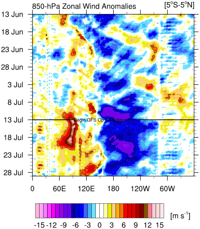
Strong trade bursts over the Nino regions continue on the GFS. IO continues with the WWBs.

Image
0 likes   
RIP Kobe Bryant

User avatar
cycloneye
Admin
Admin
Posts: 146357
Age: 69
Joined: Thu Oct 10, 2002 10:54 am
Location: San Juan, Puerto Rico

Re: 2025 ENSO Updates

#183 Postby cycloneye » Mon Jul 21, 2025 3:56 pm

The weekly CPC update of 7/21/25 has niño 3.4 at -0.2C at cool neutral.

https://www.cpc.ncep.noaa.gov/products/ ... ts-web.pdf

Image
0 likes   
Visit the Caribbean-Central America Weather Thread where you can find at first post web cams,radars
and observations from Caribbean basin members Click Here

User avatar
cycloneye
Admin
Admin
Posts: 146357
Age: 69
Joined: Thu Oct 10, 2002 10:54 am
Location: San Juan, Puerto Rico

Re: 2025 ENSO Updates

#184 Postby cycloneye » Mon Jul 21, 2025 3:58 pm

The warm waters try to rise to the surface, but the cooler waters don't let them do it.

Image
0 likes   
Visit the Caribbean-Central America Weather Thread where you can find at first post web cams,radars
and observations from Caribbean basin members Click Here

User avatar
Kingarabian
S2K Supporter
S2K Supporter
Posts: 16108
Joined: Sat Aug 08, 2009 3:06 am
Location: Honolulu, Hawaii

Re: 2025 ENSO Updates

#185 Postby Kingarabian » Sun Jul 27, 2025 5:19 pm

Significant upwelling being picked up on the buoys.
2 likes   
RIP Kobe Bryant

User avatar
Yellow Evan
Professional-Met
Professional-Met
Posts: 16172
Age: 27
Joined: Fri Jul 15, 2011 12:48 pm
Location: Henderson, Nevada/Honolulu, HI
Contact:

Re: 2025 ENSO Updates

#186 Postby Yellow Evan » Sun Jul 27, 2025 11:54 pm

Upcoming period of weaker trades on the EPS over the CPAC.
0 likes   

User avatar
Kingarabian
S2K Supporter
S2K Supporter
Posts: 16108
Joined: Sat Aug 08, 2009 3:06 am
Location: Honolulu, Hawaii

Re: 2025 ENSO Updates

#187 Postby Kingarabian » Mon Jul 28, 2025 8:02 am

Yellow Evan wrote:Upcoming period of weaker trades on the EPS over the CPAC.
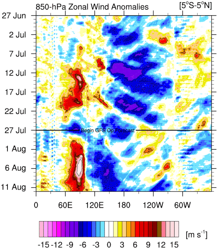
MJO moving through. Pretty meaningful pulse as this may trigger 6 systems combined in the CPAC and EPAC.
Last edited by Kingarabian on Mon Jul 28, 2025 8:04 am, edited 1 time in total.
0 likes   
RIP Kobe Bryant

User avatar
Kingarabian
S2K Supporter
S2K Supporter
Posts: 16108
Joined: Sat Aug 08, 2009 3:06 am
Location: Honolulu, Hawaii

Re: 2025 ENSO Updates

#188 Postby Kingarabian » Mon Jul 28, 2025 8:04 am

Exceptionally strong IO WWB on the GFS.

Image

That means the atmosphere is trending back to La Nina if it verifies.
0 likes   
RIP Kobe Bryant

User avatar
cycloneye
Admin
Admin
Posts: 146357
Age: 69
Joined: Thu Oct 10, 2002 10:54 am
Location: San Juan, Puerto Rico

Re: 2025 ENSO Updates

#189 Postby cycloneye » Mon Jul 28, 2025 9:14 am

No change to niño 3.4 as it remains at -0.2C. The depth of the ENSO area is cooling.

Image

https://www.cpc.ncep.noaa.gov/products/ ... ts-web.pdf
0 likes   
Visit the Caribbean-Central America Weather Thread where you can find at first post web cams,radars
and observations from Caribbean basin members Click Here

User avatar
Kingarabian
S2K Supporter
S2K Supporter
Posts: 16108
Joined: Sat Aug 08, 2009 3:06 am
Location: Honolulu, Hawaii

Re: 2025 ENSO Updates

#190 Postby Kingarabian » Sat Aug 02, 2025 3:31 pm

SOI has been anemic in regards to an actual La Nina atmosphere setting up. Still firmly in cool neutral territory.

That being said trade burst showing up on the models near the dateline.
0 likes   
RIP Kobe Bryant

User avatar
weeniepatrol
Category 5
Category 5
Posts: 1307
Joined: Sat Aug 22, 2020 5:30 pm
Location: WA State

Re: 2025 ENSO Updates

#191 Postby weeniepatrol » Sun Aug 03, 2025 9:39 pm

Kingarabian wrote:
That being said trade burst showing up on the models near the dateline.


"today ends with a y"

Image

Image

:lol:
1 likes   

User avatar
cycloneye
Admin
Admin
Posts: 146357
Age: 69
Joined: Thu Oct 10, 2002 10:54 am
Location: San Juan, Puerto Rico

Re: 2025 ENSO Updates

#192 Postby cycloneye » Mon Aug 04, 2025 3:13 pm

The CPC 8/4/25 update has niño 3.4 down to -0.3C.

https://www.cpc.ncep.noaa.gov/products/ ... ts-web.pdf
0 likes   
Visit the Caribbean-Central America Weather Thread where you can find at first post web cams,radars
and observations from Caribbean basin members Click Here

LarryWx
S2K Supporter
S2K Supporter
Posts: 6508
Joined: Sun Sep 07, 2003 2:04 pm
Location: GA

Re: 2025 ENSO Updates

#193 Postby LarryWx » Mon Aug 04, 2025 3:42 pm

cycloneye wrote:The CPC 8/4/25 update has niño 3.4 down to -0.3C.

https://www.cpc.ncep.noaa.gov/products/ ... ts-web.pdf


That’s not a good thing to see if you don’t want above average activity from the NE Caribbean to the SE corridor. That means RONI is likely in low end weak La Niña (~-0.6).
1 likes   
Personal Forecast Disclaimer:
The posts in this forum are NOT official forecasts and should not be used as such. They are just the opinion of the poster and may or may not be backed by sound meteorological data. They are NOT endorsed by any professional institution or storm2k.org. For official information, please refer to the NHC and NWS products.

User avatar
weeniepatrol
Category 5
Category 5
Posts: 1307
Joined: Sat Aug 22, 2020 5:30 pm
Location: WA State

Re: 2025 ENSO Updates: July NMME with La Niña for Fall and Winter

#194 Postby weeniepatrol » Wed Aug 06, 2025 10:42 pm

weeniepatrol wrote:
Kingarabian wrote:Waters east of Japan are on fire.


PDO is collapsing.

https://imgur.com/SwMVlgc


July will probably be the coolest PDO monthly in our records. NOAA came in at an unbelievable -4.0 sigma


The Bay Area is experiencing its coolest Summer since 1965.

https://www.foxweather.com/weather-news/san-francisco-california-coldest-summer-2025

As I write this from the Portland area, today failed to reach 70F and is around 15 degrees below average. Over half an inch of rain in the previous 24 hours; this is the coolest and wettest August weather I have ever experienced in over a decade of living here.
3 likes   

User avatar
Woofde
Category 2
Category 2
Posts: 516
Joined: Tue Jul 06, 2021 11:33 am

Re: 2025 ENSO Updates: July NMME with La Niña for Fall and Winter

#195 Postby Woofde » Thu Aug 07, 2025 2:06 am

weeniepatrol wrote:
weeniepatrol wrote:
Kingarabian wrote:Waters east of Japan are on fire.


PDO is collapsing.

https://imgur.com/SwMVlgc


July will probably be the coolest PDO monthly in our records. NOAA came in at an unbelievable -4.0 sigma


The Bay Area is experiencing its coolest Summer since 1965.

https://www.foxweather.com/weather-news/san-francisco-california-coldest-summer-2025

As I write this from the Portland area, today failed to reach 70F and is around 15 degrees below average. Over half an inch of rain in the previous 24 hours; this is the coolest and wettest August weather I have ever experienced in over a decade of living here.
It's a very interesting -PDO. The southern region is very typical looking in shape and value, while the warm tongue is extremely anomalous; breaking records and ovviously influenced by warming SSTs. It's also notable that the northern branch of cooler SST's you would expect to see around Alaska is absent at the moment.

If this period of -PDO inevitably inverts and swaps those SST anomalies that have been present in recent times near Japan to the coast of California. I would not be surprised to see record breaking floods and rainfall in California. There's historically no precedent for waters that warm.Image
3 likes   

User avatar
weeniepatrol
Category 5
Category 5
Posts: 1307
Joined: Sat Aug 22, 2020 5:30 pm
Location: WA State

Re: 2025 ENSO Updates: July NMME with La Niña for Fall and Winter

#196 Postby weeniepatrol » Thu Aug 07, 2025 2:11 am

Woofde wrote:
weeniepatrol wrote:
weeniepatrol wrote:
PDO is collapsing.

https://imgur.com/SwMVlgc


July will probably be the coolest PDO monthly in our records. NOAA came in at an unbelievable -4.0 sigma

https://imgur.com/B4M2lnw

The Bay Area is experiencing its coolest Summer since 1965.

https://www.foxweather.com/weather-news/san-francisco-california-coldest-summer-2025

As I write this from the Portland area, today failed to reach 70F and is around 15 degrees below average. Over half an inch of rain in the previous 24 hours; this is the coolest and wettest August weather I have ever experienced in over a decade of living here.
It's a very interesting -PDO. The southern region is very typical looking in shape and value, while the warm tongue is extremely anomalous; breaking records and ovviously influenced by warming SSTs. It's also notable that the northern branch of cooler SST's you would expect to see around Alaska is absent at the moment.

If this period of -PDO inevitably inverts and swaps those SST anomalies that have been present in recent times near Japan to the coast of California. I would not be surprised to see record breaking floods and rainfall in California. There's historically no precedent for waters that warm.https://uploads.tapatalk-cdn.com/20250807/214c5347b8a56faec60eda9146ffcbaf.jpg


Yeah, it’s not the most traditional cool horseshoe but those waters east of Japan are projecting so strongly onto -pdo that it doesn’t matter
1 likes   

User avatar
Kingarabian
S2K Supporter
S2K Supporter
Posts: 16108
Joined: Sat Aug 08, 2009 3:06 am
Location: Honolulu, Hawaii

Re: 2025 ENSO Updates: July NMME with La Niña for Fall and Winter

#197 Postby Kingarabian » Thu Aug 07, 2025 11:05 am

weeniepatrol wrote:
weeniepatrol wrote:
Kingarabian wrote:Waters east of Japan are on fire.


PDO is collapsing.

https://imgur.com/SwMVlgc


July will probably be the coolest PDO monthly in our records. NOAA came in at an unbelievable -4.0 sigma

https://imgur.com/B4M2lnw

The Bay Area is experiencing its coolest Summer since 1965.

https://www.foxweather.com/weather-news/san-francisco-california-coldest-summer-2025

As I write this from the Portland area, today failed to reach 70F and is around 15 degrees below average. Over half an inch of rain in the previous 24 hours; this is the coolest and wettest August weather I have ever experienced in over a decade of living here.

Models have Henriette intensifying well north of Hawaii. Almost unheard of in non El Nino years. Just shows how far east those warm anomalies east of Japan are extending.

The PDO is historically cool. But whats starting to become abnormal is the length of this -PDO period and the way its being driven by the waters east of Japan.
1 likes   
RIP Kobe Bryant

User avatar
weeniepatrol
Category 5
Category 5
Posts: 1307
Joined: Sat Aug 22, 2020 5:30 pm
Location: WA State

Re: 2025 ENSO Updates: July NMME with La Niña for Fall and Winter

#198 Postby weeniepatrol » Fri Aug 08, 2025 6:11 pm

Kingarabian wrote:
weeniepatrol wrote:
weeniepatrol wrote:
PDO is collapsing.

https://imgur.com/SwMVlgc


July will probably be the coolest PDO monthly in our records. NOAA came in at an unbelievable -4.0 sigma

https://imgur.com/B4M2lnw

The Bay Area is experiencing its coolest Summer since 1965.

https://www.foxweather.com/weather-news/san-francisco-california-coldest-summer-2025

As I write this from the Portland area, today failed to reach 70F and is around 15 degrees below average. Over half an inch of rain in the previous 24 hours; this is the coolest and wettest August weather I have ever experienced in over a decade of living here.

Models have Henriette intensifying well north of Hawaii. Almost unheard of in non El Nino years. Just shows how far east those warm anomalies east of Japan are extending.

The PDO is historically cool. But whats starting to become abnormal is the length of this -PDO period and the way its being driven by the waters east of Japan.


Can't help but think that at least some of the current -pdo must be at least partially forced by AGW; with Hadley cell expansion and associated anomalous warmth east of Japan + anomalous subtropical Pacific ridging projecting onto -PDO. We'd still be in a negative phase right now without the climate change signal, but I do think it'd be less negative for sure.
0 likes   

User avatar
cycloneye
Admin
Admin
Posts: 146357
Age: 69
Joined: Thu Oct 10, 2002 10:54 am
Location: San Juan, Puerto Rico

Re: 2025 ENSO Updates

#199 Postby cycloneye » Thu Aug 14, 2025 8:51 am

0 likes   
Visit the Caribbean-Central America Weather Thread where you can find at first post web cams,radars
and observations from Caribbean basin members Click Here

User avatar
Kingarabian
S2K Supporter
S2K Supporter
Posts: 16108
Joined: Sat Aug 08, 2009 3:06 am
Location: Honolulu, Hawaii

Re: 2025 ENSO Updates

#200 Postby Kingarabian » Thu Aug 14, 2025 8:53 am

GFS has a large Pacific trade burst in its forecast.

Image
0 likes   
RIP Kobe Bryant


Return to “Talkin' Tropics”

Who is online

Users browsing this forum: cajungal, MarioProtVI, Stratton23, TampaWxLurker, WaveBreaking and 67 guests