EP, 06, 2025070106, , BEST, 0, 167N, 1047W, 70, 984, HU
EPAC: FLOSSIE - Post-Tropical - Discussion
Moderator: S2k Moderators
-
DorkyMcDorkface

- Category 5

- Posts: 1063
- Age: 28
- Joined: Mon Sep 30, 2019 1:32 pm
- Location: Mid-Atlantic
Re: EPAC: FLOSSIE - Hurricane - Discussion
0 likes
Please note the thoughts expressed by this account are solely those of the user and are from a hobbyist perspective. For more comprehensive analysis, consult an actual professional meteorologist or meteorological agency.
Floyd 1999 | Isabel 2003 | Hanna 2008 | Irene 2011 | Sandy 2012 | Isaias 2020
-
cycloneye

- Admin

- Posts: 149817
- Age: 69
- Joined: Thu Oct 10, 2002 10:54 am
- Location: San Juan, Puerto Rico
Re: EPAC: FLOSSIE - Hurricane - Discussion
BULLETIN
Hurricane Flossie Advisory Number 9
NWS National Hurricane Center Miami FL EP062025
300 AM CST Tue Jul 01 2025
...FLOSSIE CONTINUES TO STRENGTHEN OFFSHORE THE COAST OF SOUTHWEST
MEXICO...
SUMMARY OF 300 AM CST...0900 UTC...INFORMATION
----------------------------------------------
LOCATION...16.9N 105.1W
ABOUT 155 MI...250 KM SSW OF MANZANILLO MEXICO
MAXIMUM SUSTAINED WINDS...85 MPH...140 KM/H
PRESENT MOVEMENT...WNW OR 300 DEGREES AT 10 MPH...17 KM/H
MINIMUM CENTRAL PRESSURE...981 MB...28.97 INCHES
Hurricane Flossie Discussion Number 9
NWS National Hurricane Center Miami FL EP062025
300 AM CST Tue Jul 01 2025
Flossie continues to strengthen early this morning, evident by an
expanding central dense overcast (CDO) over the low-level center of
the cyclone. A couple recent scatterometer passes at 0337z and
0428z helped in locating the center underneath the CDO, and assisted
with the refinement of the 34 and 50 knot wind radii. The latest
subjective Dvorak intensity estimates came in at T4.0/65 knots from
both SAB and TAFB. The objective intensity estimates ranged from 69
to 79 knots at 06z. Based on a blend of these estimates, and taking
into account the improved satellite presentation during the past few
hours, the initial intensity has been raised to 75 knots for this
advisory.
Flossie is heading toward the west-northwest or 300/09 knots. This
motion is expected to continue during the next several days with a
slight decrease in forward speed, as the cyclone is steered into a
weakness in the mid-level ridge to the northwest of the system. The
track forecast is very close to the previous advisory and is closely
aligned with a blend of the latest HCCA, TVCE, and FSSE consensus
aids as well as the latest EC-AIFS run.
The environment will remain very conducive for strengthening during
the next 24 to 36 hours, with warm sea surface temperatures of
28/29C, abundant mid-level moisture, and light vertical wind shear.
The latest SHIPS RI probabilities show a greater than 40 percent
chance of a 25-knot increase in 24 hours, and the official forecast
reflects this. Rapid weakening will then begin by 48 hours as
Flossie moves over progressively cooler water and begins to entrain
dry mid-level air. The system is forecast to become a post-tropical
low by 72 hours and a remnant low at 96 hours. The intensity
forecast is on the high end of the intensity aids, closest to SHIPS
and NNIC.
KEY MESSAGES:
1. The outer bands of Hurricane Flossie should bring locally heavy
rainfall to coastal portions of the Mexican states of Guerrero,
Michoacán, Colima, and Jalisco through Wednesday. Life-threatening
flooding and mudslides are possible, particularly in steep terrain.
2. Tropical storm conditions are expected in portions of the
tropical storm warning area in southwestern Mexico, through today.
FORECAST POSITIONS AND MAX WINDS
INIT 01/0900Z 16.9N 105.1W 75 KT 85 MPH
12H 01/1800Z 17.5N 106.2W 85 KT 100 MPH
24H 02/0600Z 18.4N 107.7W 95 KT 110 MPH
36H 02/1800Z 19.2N 109.0W 95 KT 110 MPH
48H 03/0600Z 20.0N 110.2W 75 KT 85 MPH
60H 03/1800Z 20.9N 111.3W 55 KT 65 MPH
72H 04/0600Z 21.9N 112.5W 40 KT 45 MPH...POST-TROPICAL
96H 05/0600Z 23.7N 114.9W 30 KT 35 MPH...POST-TROP/REMNT LOW
120H 06/0600Z 24.0N 118.0W 20 KT 25 MPH...POST-TROP/REMNT LOW
$$
Forecaster Jelsema
2 likes
Visit the Caribbean-Central America Weather Thread where you can find at first post web cams,radars
and observations from Caribbean basin members Click Here
and observations from Caribbean basin members Click Here
-
cycloneye
- Admin
- Posts: 149817
- Age: 69
- Joined: Thu Oct 10, 2002 10:54 am
- Location: San Juan, Puerto Rico
Re: EPAC: FLOSSIE - Hurricane - Discussion
BULLETIN
Hurricane Flossie Intermediate Advisory Number 9A
NWS National Hurricane Center Miami FL EP062025
600 AM CST Tue Jul 01 2025
...FLOSSIE CONTINUES MOVING WEST-NORTHWESTWARD OFFSHORE OF THE
COAST OF MEXICO...
SUMMARY OF 600 AM CST...1200 UTC...INFORMATION
----------------------------------------------
LOCATION...17.1N 105.6W
ABOUT 155 MI...250 KM SSW OF MANZANILLO MEXICO
MAXIMUM SUSTAINED WINDS...90 MPH...145 KM/H
PRESENT MOVEMENT...WNW OR 300 DEGREES AT 10 MPH...17 KM/H
MINIMUM CENTRAL PRESSURE...979 MB...28.91 INCHES
0 likes
Visit the Caribbean-Central America Weather Thread where you can find at first post web cams,radars
and observations from Caribbean basin members Click Here
and observations from Caribbean basin members Click Here
-
cycloneye
- Admin
- Posts: 149817
- Age: 69
- Joined: Thu Oct 10, 2002 10:54 am
- Location: San Juan, Puerto Rico
Re: EPAC: FLOSSIE - Hurricane - Discussion
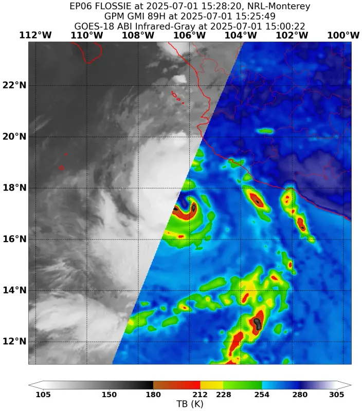
A more clear eye now.

1 likes
Visit the Caribbean-Central America Weather Thread where you can find at first post web cams,radars
and observations from Caribbean basin members Click Here
and observations from Caribbean basin members Click Here
-
Hurricane2000
- Tropical Depression

- Posts: 57
- Joined: Sat Dec 28, 2024 4:50 pm


Re: EPAC: FLOSSIE - Hurricane - Discussion
Flossie is looking really impressive right now. Between the current satellite presentation and the NHC's most recent forecast of a fairly-sustained 95 kt peak, I think it's very plausible that this could become the EPac's second major hurricane of 2025.
1 likes
-
cycloneye
- Admin
- Posts: 149817
- Age: 69
- Joined: Thu Oct 10, 2002 10:54 am
- Location: San Juan, Puerto Rico
Re: EPAC: FLOSSIE - Hurricane - Discussion
Forecast to reach 100kt.
BULLETIN
Hurricane Flossie Advisory Number 10
NWS National Hurricane Center Miami FL EP062025
900 AM CST Tue Jul 01 2025
...FLOSSIE STRENGTHENS FURTHER AS RAINBANDS AFFECT PORTIONS OF THE
COAST OF MEXICO...
SUMMARY OF 900 AM CST...1500 UTC...INFORMATION
----------------------------------------------
LOCATION...17.4N 105.9W
ABOUT 150 MI...245 KM SW OF MANZANILLO MEXICO
ABOUT 460 MI...740 KM SE OF CABO SAN LUCAS MEXICO
MAXIMUM SUSTAINED WINDS...100 MPH...155 KM/H
PRESENT MOVEMENT...NW OR 305 DEGREES AT 10 MPH...17 KM/H
MINIMUM CENTRAL PRESSURE...974 MB...28.77 INCHES
Hurricane Flossie Discussion Number 10
NWS National Hurricane Center Miami FL EP062025
900 AM CST Tue Jul 01 2025
Flossie is still intensifying, with conventional satellite imagery
showing a curved band pattern with cloud tops colder than -80C and a
formative eye. In addition, recent microwave overpasses show an eye
and eyewall present under the convective overcast. The latest
subjective and objective satellite intensity estimates are generally
in the 75-85 kt range, and based on current trends the initial
intensity is set at 85 kt.
The initial motion is 305/9 kt. A general northwestward to
west-northwestward motion with some decrease in forward speed is
expected during the next 3-4 days as Flossie moves toward a weakness
in the subtropical ridge. After that time, the cyclone or its
remnants is forecast to turn westward as they become steered more by
the low-level flow. The new forecast track, which generally splits
the difference between the HCCA corrected consensus and the other
consensus models, is a little north of the previous forecast through
72 h and a little south of the previous track after that time.
The wind shear and moisture are forecast to be favorable for
strengthening as long as Flossie remains over warm water. While
the hurricane is starting to move over decreasing sea surface
temperatures, the intensity guidance suggests it will take about
24 h to reach water cold enough to stop intensification. Based on
this, the new intensity forecast calls for another 24 h of
strengthening. After that, Flossie is expected to rapidly weaken,
with the system becoming post-tropical by 72 h and a remnant low by
96 h. The forecast is near the high end of the intensity guidance
for the first 36 h and near the intensity consensus for the rest of
the forecast period.
KEY MESSAGES:
1. Outer bands of Hurricane Flossie should continue to bring locally
heavy rainfall to coastal portions of the Mexican states of
Michoacán, Colima, and Jalisco into Wednesday. Localized flash
flooding is possible.
2. Tropical storm conditions are expected in portions of the
tropical storm warning area in southwestern Mexico for the next
several hours.
FORECAST POSITIONS AND MAX WINDS
INIT 01/1500Z 17.4N 105.9W 85 KT 100 MPH
12H 02/0000Z 18.1N 107.0W 95 KT 110 MPH
24H 02/1200Z 19.0N 108.4W 100 KT 115 MPH
36H 03/0000Z 19.8N 109.6W 85 KT 100 MPH
48H 03/1200Z 20.6N 110.8W 70 KT 80 MPH
60H 04/0000Z 21.4N 112.0W 55 KT 65 MPH
72H 04/1200Z 22.2N 113.2W 40 KT 45 MPH...POST-TROPICAL
96H 05/1200Z 23.5N 116.0W 25 KT 30 MPH...POST-TROP/REMNT LOW
120H 06/1200Z 24.0N 119.0W 20 KT 25 MPH...POST-TROP/REMNT LOW
$$
Forecaster Beven
1 likes
Visit the Caribbean-Central America Weather Thread where you can find at first post web cams,radars
and observations from Caribbean basin members Click Here
and observations from Caribbean basin members Click Here
-
Yellow Evan

- Professional-Met

- Posts: 16257
- Age: 27
- Joined: Fri Jul 15, 2011 12:48 pm
- Location: Henderson, Nevada/Honolulu, HI
- Contact:
Re: EPAC: FLOSSIE - Hurricane - Discussion: Forecast to reach 100kt as peak intensity
I’d say we are on track for Category 4 tbh.
0 likes
-
DorkyMcDorkface
- Category 5
- Posts: 1063
- Age: 28
- Joined: Mon Sep 30, 2019 1:32 pm
- Location: Mid-Atlantic
Re: EPAC: FLOSSIE - Hurricane - Discussion: Forecast to reach 100kt as peak intensity
Thinkin' we may have an overperformer on our hands

3 likes
Please note the thoughts expressed by this account are solely those of the user and are from a hobbyist perspective. For more comprehensive analysis, consult an actual professional meteorologist or meteorological agency.
Floyd 1999 | Isabel 2003 | Hanna 2008 | Irene 2011 | Sandy 2012 | Isaias 2020
-
Sciencerocks
- Category 5
- Posts: 10194
- Age: 40
- Joined: Thu Jul 06, 2017 1:51 am

-
Yellow Evan
- Professional-Met
- Posts: 16257
- Age: 27
- Joined: Fri Jul 15, 2011 12:48 pm
- Location: Henderson, Nevada/Honolulu, HI
- Contact:
Re: EPAC: FLOSSIE - Hurricane - Discussion: Forecast to reach 100kt as peak intensity

CDO is quite circular but this is still VHT dominant, resulting in convective asymmetries and the eye often being partially obscured.
1 likes
-
cycloneye
- Admin
- Posts: 149817
- Age: 69
- Joined: Thu Oct 10, 2002 10:54 am
- Location: San Juan, Puerto Rico
Re: EPAC: FLOSSIE - Hurricane - Discussion: Forecast to reach 100kt as peak intensity
0 likes
Visit the Caribbean-Central America Weather Thread where you can find at first post web cams,radars
and observations from Caribbean basin members Click Here
and observations from Caribbean basin members Click Here
-
cycloneye
- Admin
- Posts: 149817
- Age: 69
- Joined: Thu Oct 10, 2002 10:54 am
- Location: San Juan, Puerto Rico
Re: EPAC: FLOSSIE - Hurricane - Discussion
Now up to 95 KT.
BULLETIN
Hurricane Flossie Intermediate Advisory Number 10A
NWS National Hurricane Center Miami FL EP062025
1200 PM CST Tue Jul 01 2025
...FLOSSIE CONTINUES TO STRENGTHEN...
...OUTER RAINBANDS OF FLOSSIE BRUSHING THE COAST OF SOUTHWESTERN
MEXICO...
SUMMARY OF 1200 PM CST...1800 UTC...INFORMATION
-----------------------------------------------
LOCATION...17.5N 106.5W
ABOUT 180 MI...285 KM SW OF MANZANILLO MEXICO
ABOUT 430 MI...700 KM SSE OF CABO SAN LUCAS MEXICO
MAXIMUM SUSTAINED WINDS...110 MPH...175 KM/H
PRESENT MOVEMENT...NW OR 305 DEGREES AT 10 MPH...17 KM/H
MINIMUM CENTRAL PRESSURE...966 MB...28.53 INCHES
0 likes
Visit the Caribbean-Central America Weather Thread where you can find at first post web cams,radars
and observations from Caribbean basin members Click Here
and observations from Caribbean basin members Click Here
-
Kingarabian

- S2K Supporter

- Posts: 16383
- Joined: Sat Aug 08, 2009 3:06 am
- Location: Honolulu, Hawaii
Re: EPAC: FLOSSIE - Hurricane - Discussion: Forecast to reach 100kt as peak intensity
Yellow Evan wrote:https://i.imgur.com/GgEDNrE.png
CDO is quite circular but this is still VHT dominant, resulting in convective asymmetries and the eye often being partially obscured.
Core is pretty dry which explains the appearance. Need those hot towers to push out the dry air.
2 likes
RIP Kobe Bryant
-
Sciencerocks
- Category 5
- Posts: 10194
- Age: 40
- Joined: Thu Jul 06, 2017 1:51 am

-
Sciencerocks
- Category 5
- Posts: 10194
- Age: 40
- Joined: Thu Jul 06, 2017 1:51 am

-
Yellow Evan
- Professional-Met
- Posts: 16257
- Age: 27
- Joined: Fri Jul 15, 2011 12:48 pm
- Location: Henderson, Nevada/Honolulu, HI
- Contact:
Re: EPAC: FLOSSIE - Hurricane - Discussion
TXPZ28 KNES 011813
TCSENP
A. 06E (FLOSSIE)
B. 01/1800Z
C. 17.5N
D. 106.3W
E. ONE/GOES-W
F. T5.0/5.0
G. IR/EIR/VIS
H. REMARKS...DG EYE IS SURROUNDED BY B AND EMBEDDED IN LG RESULTING IN
A DT OF 5.0 WITH NO EYE ADJUSTMENT. PT AGREES WHILE MET IS 4.5 BASED ON
A 24 HOUR RAPID DEVELOPMENT TREND. OF NOTE, THE 6 HOUR AVERAGE DT IS 5.5,
WHICH SUGGESTS THE POSSIBILITY THAT THE STORM IS STRONGER THAN INDICATED
HERE. THE FT IS BASED ON THE DT.
I. ADDL POSITIONS
NIL
...TURK
2 likes
-
cycloneye
- Admin
- Posts: 149817
- Age: 69
- Joined: Thu Oct 10, 2002 10:54 am
- Location: San Juan, Puerto Rico
Re: EPAC: FLOSSIE - Hurricane - Discussion
BULLETIN
Hurricane Flossie Advisory Number 11
NWS National Hurricane Center Miami FL EP062025
200 PM MST Tue Jul 01 2025
...FLOSSIE MOVING WEST-NORTHWESTWARD...
SUMMARY OF 200 PM MST...2100 UTC...INFORMATION
----------------------------------------------
LOCATION...17.7N 106.7W
ABOUT 180 MI...290 KM WSW OF MANZANILLO MEXICO
ABOUT 415 MI...665 KM SSE OF CABO SAN LUCAS MEXICO
MAXIMUM SUSTAINED WINDS...110 MPH...175 KM/H
PRESENT MOVEMENT...NW OR 315 DEGREES AT 7 MPH...11 KM/H
MINIMUM CENTRAL PRESSURE...966 MB...28.53 INCHES
Hurricane Flossie Discussion Number 11
NWS National Hurricane Center Miami FL EP062025
200 PM MST Tue Jul 01 2025
Flossie continues to intensify this afternoon, with deep cold
convection wrapping around the eyewall. GOES satellite visible
imagery shows an eye has been trying to clear out and warm
throughout the day. The latest subjective and objective satellite
intensity estimates are between 90-95 kt. Based on the latest trends
and these estimates, the initial intensity is set to 95 kt for this
advisory.
The initial motion is 300/9 kt. A general west-northwest to
northwestward motion is forecast over the next few days as Flossie
moves toward a weakness in the subtropical ridge. As the system
begins to weaken, a more westward motion is anticipated as the storm
is steered by the low-level wind flow. The latest NHC track forecast
track lies near the previous, which is near the HCCA corrected
consensus.
Flossie will remain in a favorable environment, with warm SSTs,
plentiful moisture, and weak wind shear for the next 12-24 hours.
Along the forecast track the system will be moving into increasingly
cooler SSTs and drier air in about 24 h. The latest NHC forecast is
for some additional strengthening in the short term, which is above
all available guidance. Afterwards, Flossie is expected to rapidly
weaken, with the system becoming post-tropical by 72 h, and a
remnant low by 96 h and dissipated by day 5. The latest NHC
intensity forecast remains at the high end of the guidance in the
short term, before trending towards the consensus aids as the system
weakens.
KEY MESSAGES:
1. Outer bands of Hurricane Flossie continue to bring locally heavy
rainfall to coastal portions of the Mexican states of Michoacán,
Colima, and Jalisco into Wednesday. Localized flash flooding is
possible.
2. Tropical storm conditions are expected in portions of the
tropical storm warning area in southwestern Mexico for the next few
hours.
FORECAST POSITIONS AND MAX WINDS
INIT 01/2100Z 17.7N 106.7W 95 KT 110 MPH
12H 02/0600Z 18.5N 107.9W 110 KT 125 MPH
24H 02/1800Z 19.5N 109.3W 90 KT 105 MPH
36H 03/0600Z 20.4N 110.7W 75 KT 85 MPH
48H 03/1800Z 21.3N 112.0W 55 KT 65 MPH
60H 04/0600Z 22.1N 113.2W 45 KT 50 MPH...POST-TROPICAL
72H 04/1800Z 22.9N 114.6W 30 KT 35 MPH...POST-TROPICAL
96H 05/1800Z 24.0N 117.4W 25 KT 30 MPH...POST-TROP/REMNT LOW
120H 06/1800Z...DISSIPATED
$$
Forecaster Kelly/E.Adams
1 likes
Visit the Caribbean-Central America Weather Thread where you can find at first post web cams,radars
and observations from Caribbean basin members Click Here
and observations from Caribbean basin members Click Here
-
Sciencerocks
- Category 5
- Posts: 10194
- Age: 40
- Joined: Thu Jul 06, 2017 1:51 am

-
cycloneye
- Admin
- Posts: 149817
- Age: 69
- Joined: Thu Oct 10, 2002 10:54 am
- Location: San Juan, Puerto Rico
Re: EPAC: FLOSSIE - Hurricane - Discussion
BULLETIN
Hurricane Flossie Intermediate Advisory Number 11A
NWS National Hurricane Center Miami FL EP062025
500 PM MST Tue Jul 01 2025
...FLOSSIE BRINGING GUSTY WINDS AND RAIN TO THE SOUTHWESTERN
COAST OF MEXICO...
SUMMARY OF 500 PM MST...0000 UTC...INFORMATION
----------------------------------------------
LOCATION...17.9N 107.1W
ABOUT 200 MI...320 KM WSW OF MANZANILLO MEXICO
ABOUT 390 MI...630 KM SSE OF CABO SAN LUCAS MEXICO
MAXIMUM SUSTAINED WINDS...110 MPH...175 KM/H
PRESENT MOVEMENT...NW OR 315 DEGREES AT 7 MPH...11 KM/H
MINIMUM CENTRAL PRESSURE...966 MB...28.53 INCHES
1 likes
Visit the Caribbean-Central America Weather Thread where you can find at first post web cams,radars
and observations from Caribbean basin members Click Here
and observations from Caribbean basin members Click Here
Who is online
Users browsing this forum: No registered users and 23 guests