EPAC: FLOSSIE - Post-Tropical - Discussion

Moderator: S2k Moderators

Message
Author
User avatar
DorkyMcDorkface
Category 3
Category 3
Posts: 887
Age: 27
Joined: Mon Sep 30, 2019 1:32 pm
Location: Mid-Atlantic

Re: EPAC: FLOSSIE - Tropical Storm - Discussion

#81 Postby DorkyMcDorkface » Mon Jun 30, 2025 8:16 am

Hurricane2022 wrote:Such a sad news we can't have any MW imagery now. I think Flossie may be starting to form a more defined core (or maybe even a weak Eyewall) at this moment.

They actually extended the deadline thankfully. Still disgraceful and absurd that we're even entertaining this notion
3 likes   
Please note the thougths expressed by this account are solely those of the user and are from a hobbyist perspective. For more comprehensive analysis, consult an actual professional meteorologist or meteorology agency.


Floyd 1999 | Isabel 2003 | Hanna 2008 | Irene 2011 | Sandy 2012 | Isaias 2020

User avatar
cycloneye
Admin
Admin
Posts: 145244
Age: 68
Joined: Thu Oct 10, 2002 10:54 am
Location: San Juan, Puerto Rico

Re: EPAC: FLOSSIE - Tropical Storm - Discussion

#82 Postby cycloneye » Mon Jun 30, 2025 9:16 am

Wrapping up nicely.

Image
2 likes   
Visit the Caribbean-Central America Weather Thread where you can find at first post web cams,radars
and observations from Caribbean basin members Click Here

User avatar
Hurricane2022
Category 5
Category 5
Posts: 1538
Joined: Tue Aug 23, 2022 11:38 pm
Location: Araçatuba, Brazil

Re: EPAC: FLOSSIE - Tropical Storm - Discussion

#83 Postby Hurricane2022 » Mon Jun 30, 2025 9:31 am

DorkyMcDorkface wrote:
Hurricane2022 wrote:Such a sad news we can't have any MW imagery now. I think Flossie may be starting to form a more defined core (or maybe even a weak Eyewall) at this moment.

They actually extended the deadline thankfully. Still disgraceful and absurd that we're even entertaining this notion

Thank God
 https://x.com/VortixWx/status/1939682588005683378

3 likes   
Sorry for the bad English sometimes...!
For reliable and detailed information for any meteorological phenomenon, please consult the National Hurricane Center, Joint Typhoon Warning Center , or your local Meteo Center.

--------

Una cvm Christo, pro Christo, et in Christo. Sit nomen Domini benedictvm.

User avatar
cycloneye
Admin
Admin
Posts: 145244
Age: 68
Joined: Thu Oct 10, 2002 10:54 am
Location: San Juan, Puerto Rico

Re: EPAC: FLOSSIE - Tropical Storm - Discussion

#84 Postby cycloneye » Mon Jun 30, 2025 9:42 am

Here we go!!!!

BULLETIN
Tropical Storm Flossie Advisory Number 6
NWS National Hurricane Center Miami FL EP062025
900 AM CST Mon Jun 30 2025

...FLOSSIE STRENGTHENING...


SUMMARY OF 900 AM CST...1500 UTC...INFORMATION
----------------------------------------------
LOCATION...15.6N 102.6W
ABOUT 160 MI...255 KM SSW OF ZIHUATANEJO MEXICO
ABOUT 260 MI...420 KM SSE OF MANZANILLO MEXICO
MAXIMUM SUSTAINED WINDS...60 MPH...95 KM/H
PRESENT MOVEMENT...NW OR 310 DEGREES AT 10 MPH...17 KM/H
MINIMUM CENTRAL PRESSURE...998 MB...29.47 INCHES


Tropical Storm Flossie Discussion Number 6
NWS National Hurricane Center Miami FL EP062025
900 AM CST Mon Jun 30 2025

Flossie continues to consolidate this morning with GOES-19 infrared
imagery showing deep convection bursting over the low-level center.
A SSMIS microwave pass from 1117 UTC this morning depicts the system
continues to become better organized, with curved banding and
potentially an inner core trying to develop. Latest Dvorak satellite
intensity estimates from TAFB and SAB have increased this advisory
to T/3.0. UW-CIMMS objective estimates range from 45 to 53 kt. Given
the improving structure and recent satellite trends, the initial
intensity is set to 50 kt for this advisory.

Environmental conditions are favorable for steady to rapid
intensification, with low vertical wind shear, plentiful moisture,
and warm SSTs. The latest NHC forecast explicitly forecasts rapid
intensification over the next 24 hours, and it is noted that some
SHIPS guidance shows a 50-65 percent chance of a 55kt increase in
the next 48 h. The NHC peak intensity forecast remains on the higher
end of the intensity guidance near the HCCA corrected consensus. In
about 48-60 hours, environmental conditions become increasingly less
favorable along the forecast track, with drier air and cooler sea
surface temperatures, which should induce a steady weakening trend.
By day 4, Flossie is forecast to become a post-tropical cyclone as
the system will struggle to produce convection within the harsh
environment.

The initial estimated motion is toward the northwest, or 310/9 kt.
A northwest to west-northwest motion is expected throughout the
forecast period, as Flossie is steered around the western periphery
of a mid-level ridge. The NHC track forecast near the previous and
lies closest to the HCCA corrected consensus aids.

Residents of Mexico should stay updated on the latest forecast. A
shift in track to the right of the official forecast could bring
more significant impacts to the coast of southwestern Mexico.

KEY MESSAGES:

1. The outer bands of Tropical Storm Flossie should bring locally
heavy rainfall to coastal portions of the Mexican states of
Guerrero, Michoacán, Colima, and Jalisco through Wednesday.
Life-threatening flooding and mudslides are possible, particularly
in steep terrain.

2. A tropical storm warning is in effect for a portion of
southwestern Mexico, where tropical storm conditions are expected
late today through Tuesday.


FORECAST POSITIONS AND MAX WINDS

INIT 30/1500Z 15.6N 102.6W 50 KT 60 MPH
12H 01/0000Z 16.5N 103.8W 60 KT 70 MPH
24H 01/1200Z 17.4N 105.4W 75 KT 85 MPH
36H 02/0000Z 18.2N 106.9W 80 KT 90 MPH
48H 02/1200Z 19.2N 108.2W 85 KT 100 MPH
60H 03/0000Z 20.0N 109.3W 75 KT 85 MPH
72H 03/1200Z 20.9N 110.4W 60 KT 70 MPH
96H 04/1200Z 23.0N 112.6W 40 KT 45 MPH...POST-TROPICAL
120H 05/1200Z 24.5N 114.0W 25 KT 30 MPH...POST-TROP/REMNT LOW

$$
Forecaster Kelly/Nepaul
1 likes   
Visit the Caribbean-Central America Weather Thread where you can find at first post web cams,radars
and observations from Caribbean basin members Click Here

Sciencerocks
Category 5
Category 5
Posts: 9152
Age: 39
Joined: Thu Jul 06, 2017 1:51 am

Re: EPAC: FLOSSIE - Tropical Storm - Discussion

#85 Postby Sciencerocks » Mon Jun 30, 2025 10:39 am

Image
0 likes   

User avatar
cycloneye
Admin
Admin
Posts: 145244
Age: 68
Joined: Thu Oct 10, 2002 10:54 am
Location: San Juan, Puerto Rico

Re: EPAC: FLOSSIE - Tropical Storm - Discussion

#86 Postby cycloneye » Mon Jun 30, 2025 10:53 am

Imaging the scheduled plane for this afternoon that was cancelled on sunday with Flossie on the virge of RI now.
0 likes   
Visit the Caribbean-Central America Weather Thread where you can find at first post web cams,radars
and observations from Caribbean basin members Click Here

User avatar
cycloneye
Admin
Admin
Posts: 145244
Age: 68
Joined: Thu Oct 10, 2002 10:54 am
Location: San Juan, Puerto Rico

Re: EPAC: FLOSSIE - Tropical Storm - Discussion

#87 Postby cycloneye » Mon Jun 30, 2025 12:44 pm

BULLETIN
Tropical Storm Flossie Intermediate Advisory Number 6A
NWS National Hurricane Center Miami FL EP062025
1200 PM CST Mon Jun 30 2025

...FLOSSIE CONTINUES TO STRENGTHEN...


SUMMARY OF 1200 PM CST...1800 UTC...INFORMATION
-----------------------------------------------
LOCATION...15.9N 103.1W
ABOUT 155 MI...250 KM SW OF ZIHUATANEJO MEXICO
ABOUT 230 MI...370 KM SSE OF MANZANILLO MEXICO
MAXIMUM SUSTAINED WINDS...65 MPH...105 KM/H
PRESENT MOVEMENT...NW OR 310 DEGREES AT 10 MPH...17 KM/H
MINIMUM CENTRAL PRESSURE...996 MB...29.42 INCHES
1 likes   
Visit the Caribbean-Central America Weather Thread where you can find at first post web cams,radars
and observations from Caribbean basin members Click Here

Sciencerocks
Category 5
Category 5
Posts: 9152
Age: 39
Joined: Thu Jul 06, 2017 1:51 am

Re: EPAC: FLOSSIE - Tropical Storm - Discussion

#88 Postby Sciencerocks » Mon Jun 30, 2025 2:33 pm

Image
0 likes   

User avatar
cycloneye
Admin
Admin
Posts: 145244
Age: 68
Joined: Thu Oct 10, 2002 10:54 am
Location: San Juan, Puerto Rico

Re: EPAC: FLOSSIE - Tropical Storm - Discussion

#89 Postby cycloneye » Mon Jun 30, 2025 3:42 pm

BULLETIN
Tropical Storm Flossie Advisory Number 7
NWS National Hurricane Center Miami FL EP062025
300 PM CST Mon Jun 30 2025

...FLOSSIE FORECAST TO BECOME A HURRICANE TONIGHT OR TUESDAY...
...LOCALLY HEAVY RAINFALL POSSIBLE ALONG COASTAL SOUTHWESTERN
MEXICO...


SUMMARY OF 300 PM CST...2100 UTC...INFORMATION
----------------------------------------------
LOCATION...16.2N 103.6W
ABOUT 170 MI...270 KM SW OF ZIHUATANEJO MEXICO
ABOUT 200 MI...320 KM SSE OF MANZANILLO MEXICO
MAXIMUM SUSTAINED WINDS...65 MPH...100 KM/H
PRESENT MOVEMENT...NW OR 305 DEGREES AT 12 MPH...19 KM/H
MINIMUM CENTRAL PRESSURE...996 MB...29.42 INCHES


Tropical Storm Flossie Discussion Number 7
NWS National Hurricane Center Miami FL EP062025
300 PM CST Mon Jun 30 2025

Flossie's satellite presentation has continued to improve throughout
the day, with convective cold cloud tops near -80C over the
low-level center, and well-defined curve banding features. An
earlier scatterometer pass around 1629 UTC showed a peak wind of 47
kt, and helped to refine the current tropical-storm-force wind
radii. Latest objective and subjective satellite intensity estimates
range from 45 to 55 kt, including a T/3.5 from TAFB. Given the
satellite trends, the intensity is set to 55 kt closes to UW-CIMSS
ADT and the TAFB Dvorak estimates.

The storm is within a favorable environment to continue
strengthening, current SSTs are around 29-30C, with low vertical
wind shear. The NHC intensity forecast remains on the higher end of
the guidance envelope and now has a peak intensity of 90 kt, closest
to the regional hurricane HAFS models. In about 48 h, environmental
conditions become increasingly more hostile, with drier air and
cooler sea surface temperatures, which should induce a steady
weakening trend. By day 4, Flossie is forecast to become a
post-tropical cyclone as the system will struggle to produce
convection within the harsh environment.

The initial estimated motion is toward the northwest, or 305/10 kt.
A northwest to west-northwest motion is expected throughout the
forecast period steered by a mid-level ridge. The NHC track forecast
was nudged slightly to the left and lies closest to the HCCA
corrected consensus aids.


KEY MESSAGES:

1. The outer bands of Tropical Storm Flossie should bring locally
heavy rainfall to coastal portions of the Mexican states of
Guerrero, Michoacán, Colima, and Jalisco through Wednesday.
Life-threatening flooding and mudslides are possible, particularly
in steep terrain.

2. Tropical storm conditions are expected in portions of the
tropical storm warning area in southwestern Mexico, later today
through Tuesday.


FORECAST POSITIONS AND MAX WINDS

INIT 30/2100Z 16.2N 103.6W 55 KT 65 MPH
12H 01/0600Z 17.0N 105.0W 70 KT 80 MPH
24H 01/1800Z 17.9N 106.7W 80 KT 90 MPH
36H 02/0600Z 18.8N 108.1W 90 KT 105 MPH
48H 02/1800Z 19.5N 109.3W 80 KT 90 MPH
60H 03/0600Z 20.1N 110.5W 65 KT 75 MPH
72H 03/1800Z 21.0N 111.6W 50 KT 60 MPH
96H 04/1800Z 22.9N 113.2W 30 KT 35 MPH...POST-TROP/REMNT LOW
120H 05/1800Z 24.9N 114.7W 20 KT 25 MPH...POST-TROP/REMNT LOW

$$
Forecaster Kelly
1 likes   
Visit the Caribbean-Central America Weather Thread where you can find at first post web cams,radars
and observations from Caribbean basin members Click Here

User avatar
Kingarabian
S2K Supporter
S2K Supporter
Posts: 15979
Joined: Sat Aug 08, 2009 3:06 am
Location: Honolulu, Hawaii

Re: EPAC: FLOSSIE - Tropical Storm - Discussion

#90 Postby Kingarabian » Mon Jun 30, 2025 5:34 pm

No solid eyewall on the latest AMSR2 pass.

Image
Last edited by Kingarabian on Mon Jun 30, 2025 5:57 pm, edited 1 time in total.
1 likes   
RIP Kobe Bryant

User avatar
Hurricane2022
Category 5
Category 5
Posts: 1538
Joined: Tue Aug 23, 2022 11:38 pm
Location: Araçatuba, Brazil

Re: EPAC: FLOSSIE - Tropical Storm - Discussion

#91 Postby Hurricane2022 » Mon Jun 30, 2025 5:50 pm

Kingarabian wrote:No solid eyewall on the latest AMSR2 pass.

Then she's likely making one now. And quickly.
Image
3 likes   
Sorry for the bad English sometimes...!
For reliable and detailed information for any meteorological phenomenon, please consult the National Hurricane Center, Joint Typhoon Warning Center , or your local Meteo Center.

--------

Una cvm Christo, pro Christo, et in Christo. Sit nomen Domini benedictvm.

User avatar
Yellow Evan
Professional-Met
Professional-Met
Posts: 16143
Age: 27
Joined: Fri Jul 15, 2011 12:48 pm
Location: Henderson, Nevada/Honolulu, HI
Contact:

Re: EPAC: FLOSSIE - Tropical Storm - Discussion

#92 Postby Yellow Evan » Mon Jun 30, 2025 6:24 pm

I still have reservations about a larger core system being able to fend off dry air and seriously intensify but it’s not impossible by any means. Category 2 or 3 is a good bet imo with 36 hours left to intensify.
2 likes   

Sciencerocks
Category 5
Category 5
Posts: 9152
Age: 39
Joined: Thu Jul 06, 2017 1:51 am

Re: EPAC: FLOSSIE - Tropical Storm - Discussion

#93 Postby Sciencerocks » Mon Jun 30, 2025 6:38 pm

Image
1 likes   

User avatar
cycloneye
Admin
Admin
Posts: 145244
Age: 68
Joined: Thu Oct 10, 2002 10:54 am
Location: San Juan, Puerto Rico

Re: EPAC: FLOSSIE - Tropical Storm - Discussion

#94 Postby cycloneye » Mon Jun 30, 2025 7:01 pm

BULLETIN
Tropical Storm Flossie Intermediate Advisory Number 7A
NWS National Hurricane Center Miami FL EP062025
600 PM CST Mon Jun 30 2025

...FLOSSIE FORECAST TO BECOME A HURRICANE TONIGHT OR TUESDAY...
...LOCALLY HEAVY RAINFALL POSSIBLE ALONG COASTAL SOUTHWESTERN
MEXICO...


SUMMARY OF 600 PM CST...0000 UTC...INFORMATION
----------------------------------------------
LOCATION...16.4N 103.9W
ABOUT 175 MI...285 KM WSW OF ZIHUATANEJO MEXICO
ABOUT 185 MI...295 KM S OF MANZANILLO MEXICO
MAXIMUM SUSTAINED WINDS...65 MPH...100 KM/H
PRESENT MOVEMENT...NW OR 305 DEGREES AT 12 MPH...19 KM/H
MINIMUM CENTRAL PRESSURE...996 MB...29.42 INCHES
0 likes   
Visit the Caribbean-Central America Weather Thread where you can find at first post web cams,radars
and observations from Caribbean basin members Click Here

User avatar
cycloneye
Admin
Admin
Posts: 145244
Age: 68
Joined: Thu Oct 10, 2002 10:54 am
Location: San Juan, Puerto Rico

Re: EPAC: FLOSSIE - Tropical Storm - Discussion

#95 Postby cycloneye » Mon Jun 30, 2025 7:44 pm

Yikes. 4.0.

A. 06E (FLOSSIE)

B. 01/0000Z

C. 16.4N

D. 103.7W

E. THREE/GOES-E

F. T4.0/4.0

G. IR/EIR/VIS

H. REMARKS...8/10 BANDING RESULTS IN A DT OF 3.5. THE MET EQUALS 4.0
BASED ON A RAPIDLY DEVOLVING TREND AND THE PT EQUALS 4.0. THE FT IS
BASED ON THE MET DUE TO THE BANDING NOT BEING CLEAR CUT.

I. ADDL POSITIONS

NIL


...LINER
2 likes   
Visit the Caribbean-Central America Weather Thread where you can find at first post web cams,radars
and observations from Caribbean basin members Click Here

User avatar
Kingarabian
S2K Supporter
S2K Supporter
Posts: 15979
Joined: Sat Aug 08, 2009 3:06 am
Location: Honolulu, Hawaii

Re: EPAC: FLOSSIE - Tropical Storm - Discussion

#96 Postby Kingarabian » Mon Jun 30, 2025 8:41 pm

Agree here. Think this is a low end Cat.1.
2 likes   
RIP Kobe Bryant

User avatar
Yellow Evan
Professional-Met
Professional-Met
Posts: 16143
Age: 27
Joined: Fri Jul 15, 2011 12:48 pm
Location: Henderson, Nevada/Honolulu, HI
Contact:

Re: EPAC: FLOSSIE - Tropical Storm - Discussion

#97 Postby Yellow Evan » Mon Jun 30, 2025 9:36 pm

06E FLOSSIE 250701 0000 16.4N 103.9W EPAC 65 988
1 likes   

User avatar
Yellow Evan
Professional-Met
Professional-Met
Posts: 16143
Age: 27
Joined: Fri Jul 15, 2011 12:48 pm
Location: Henderson, Nevada/Honolulu, HI
Contact:

Re: EPAC: FLOSSIE - Tropical Storm - Discussion

#98 Postby Yellow Evan » Mon Jun 30, 2025 9:41 pm

Image

With convection wrapping around into the upshear right, likely have a solid core together although not closed off yet. Need microwave to give us a better idea on core size.
3 likes   

User avatar
cycloneye
Admin
Admin
Posts: 145244
Age: 68
Joined: Thu Oct 10, 2002 10:54 am
Location: San Juan, Puerto Rico

Re: EPAC: FLOSSIE - Hurricane - Discussion

#99 Postby cycloneye » Mon Jun 30, 2025 10:00 pm

Is now oficiallly a hurricane.

BULLETIN
Hurricane Flossie Advisory Number 8
NWS National Hurricane Center Miami FL EP062025
900 PM CST Mon Jun 30 2025

...FLOSSIE STRENGTHENS INTO A HURRICANE OFFSHORE SOUTHWEST MEXICO...


SUMMARY OF 900 PM CST...0300 UTC...INFORMATION
----------------------------------------------
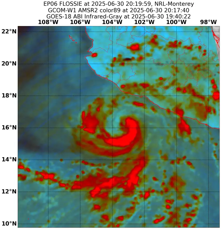
LOCATION...16.5N 104.3W
ABOUT 175 MI...280 KM S OF MANZANILLO MEXICO
MAXIMUM SUSTAINED WINDS...75 MPH...120 KM/H
PRESENT MOVEMENT...WNW OR 300 DEGREES AT 10 MPH...17 KM/H
MINIMUM CENTRAL PRESSURE...988 MB...29.18 INCHES


Hurricane Flossie Discussion Number 8
NWS National Hurricane Center Miami FL EP062025
900 PM CST Mon Jun 30 2025

The satellite presentation of Flossie has continued to improve this
evening, with a hint of an eye now possibly developing in the past
hour or so. The latest subjective Dvorak intensity estimates came in
at T4.0/65 knots and T3.5/55 knots from SAB and TAFB respectively.
The objective intensity estimates range from 56 to 62 knots at 00z
and have since increased to between 62 and 74 knots. Based on these
data and the improved satellite appearance, the initial intensity
has been raised to 65 knots for this advisory package, making
Flossie a hurricane.

Flossie is heading toward the west-northwest or 300/09 knots. This
motion with a gradual decrease in forward speed is expected during
the next several days as the cyclone is steered into a weakness in
the mid-level ridge to the northwest. The track forecast is very
close to the previous advisory and is closely aligned with a
blend of the latest HCCA, TVCE and FSSE consensus aids.

The environment will remain very conducive for strengthening during
the next 36 hours, with warm sea surface temperatures of 28/29C,
abundant mid-level moisture, and light vertical wind shear. In
fact, the latest SHIPS RI probabilities show a greater than 60%
chance of a 25-knot increase in 24 hours, and the official
forecast reflects this. Additional strengthening is forecast
through 36 hours, with the cyclone beginning to weaken by 48 hours
as it moves over cooler water. Rather rapid weakening will then
follow as Flossie moves over progressively cooler water and begins
to entrain dry mid-level air. The system is forecast to become a
post-tropical low by 72 hours and a post-tropical remnant low at
96 hours. The intensity forecast is on the high end of the
intensity aids, closest to SHIPS and NNIC, which show rapid
intensification.


KEY MESSAGES:

1. The outer bands of Tropical Storm Flossie should bring locally
heavy rainfall to coastal portions of the Mexican states of
Guerrero, Michoacán, Colima, and Jalisco through Wednesday.
Life-threatening flooding and mudslides are possible, particularly
in steep terrain.

2. Tropical storm conditions are expected in portions of the
tropical storm warning area in southwestern Mexico, tonight
through Tuesday.


FORECAST POSITIONS AND MAX WINDS

INIT 01/0300Z 16.5N 104.3W 65 KT 75 MPH
12H 01/1200Z 17.4N 105.7W 75 KT 85 MPH
24H 02/0000Z 18.2N 107.3W 90 KT 105 MPH
36H 02/1200Z 18.9N 108.7W 95 KT 110 MPH
48H 03/0000Z 19.5N 109.7W 85 KT 100 MPH
60H 03/1200Z 20.0N 110.4W 65 KT 75 MPH
72H 04/0000Z 21.0N 111.4W 50 KT 60 MPH...POST-TROPICAL
96H 05/0000Z 23.0N 113.5W 30 KT 35 MPH...POST-TROP/REMNT LOW
120H 06/0000Z 24.3N 116.0W 20 KT 25 MPH...POST-TROP/REMNT LOW

$$
Forecaster Jelsema
1 likes   
Visit the Caribbean-Central America Weather Thread where you can find at first post web cams,radars
and observations from Caribbean basin members Click Here

User avatar
Kingarabian
S2K Supporter
S2K Supporter
Posts: 15979
Joined: Sat Aug 08, 2009 3:06 am
Location: Honolulu, Hawaii

Re: EPAC: FLOSSIE - Hurricane - Discussion

#100 Postby Kingarabian » Mon Jun 30, 2025 10:59 pm

Recent IR images show that this is switching to a eye scene type. Which will automatically open up the door for T5.5 if it persists and after it passes constraints.
0 likes   
RIP Kobe Bryant


Return to “2025”

Who is online

Users browsing this forum: No registered users and 6 guests