2025 Global Model Runs Discussion (Out thru day 16)
Moderator: S2k Moderators
Forum rules

The posts in this forum are NOT official forecasts and should not be used as such. They are just the opinion of the poster and may or may not be backed by sound meteorological data. They are NOT endorsed by any professional institution or STORM2K. For official information, please refer to products from the National Hurricane Center and National Weather Service.
-
Hypercane_Kyle

- Category 5

- Posts: 3465
- Joined: Sat Mar 07, 2015 7:58 pm
- Location: Cape Canaveral, FL
Re: 2025 Global Model Runs Discussion (Out thru day 16)
Seems to be broad agreement across the Euro, GFS, and Canadian for tropical development off Florida to start July.
1 likes
My posts are my own personal opinion, defer to the National Hurricane Center (NHC) and other NOAA products for decision making during hurricane season.
-
Stratton23
- Category 5
- Posts: 3576
- Joined: Fri Jul 21, 2023 10:59 pm
- Location: Katy, Tx
Re: 2025 Global Model Runs Discussion (Out thru day 16)
Wouldn’t be surprised to see a lemon off the florida east coast and expanding to the eastern gulf within the week, GFS/ CMC/ Euro all have something
0 likes
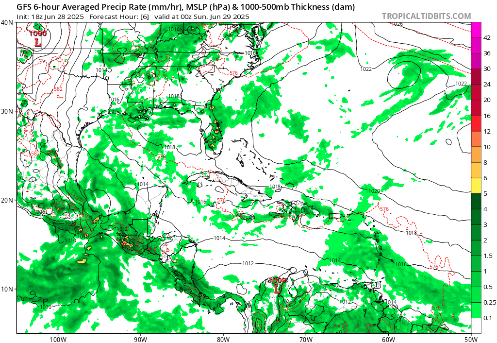
Re: 2025 Global Model Runs Discussion (Out thru day 16)
Pretty big spread on this one
12ZGFS Gulf side

canadian Off Southeast

Icon, Off southeast

euro off the southeast
The ensembles and google's new one is all over Link here
Pretty annoying for any 4th of July plans this coming weekend pretty much anywhere in the south east.
12ZGFS Gulf side
canadian Off Southeast
Icon, Off southeast
euro off the southeast
The ensembles and google's new one is all over Link here
Pretty annoying for any 4th of July plans this coming weekend pretty much anywhere in the south east.
2 likes

Re: 2025 Global Model Runs Discussion (Out thru day 16)
Add in the 12z Euro-AI as it develops a weak low off the FL west coast and meanders it slowly NW toward the FL panhandle. All models point toward slow development in 5 to 7 days. All are weak so far.
0 likes
-
Stratton23
- Category 5
- Posts: 3576
- Joined: Fri Jul 21, 2023 10:59 pm
- Location: Katy, Tx
Re: 2025 Global Model Runs Discussion (Out thru day 16)
Looking at the 500 mb height pattern on ensembles at this range, at least to me, if something were to try to get going in the NE gulf, it would get shoved to the west because ensembles favor strong upper level ridging over the eastern and central US, things can change but ensembles have been rather consistent with showing this upper air pattern
1 likes
Re: 2025 Global Model Runs Discussion (Out thru day 16)
WPC 7 day QPF shows 5"+ along the Gulf coast from Tampa bay to Mobile bay. Very wet times ahead for the NE Gulf region.
2 likes
-
Stratton23
- Category 5
- Posts: 3576
- Joined: Fri Jul 21, 2023 10:59 pm
- Location: Katy, Tx
Re: 2025 Global Model Runs Discussion (Out thru day 16)
Time frame for any development in the NE gulf has moved up on the 18z GFS, starts developing a surface low at day 5, by day 7 its a tropical storm taking more of a westward track in the gulf
0 likes
-
DunedinDave
- Category 1

- Posts: 269
- Joined: Fri Aug 25, 2023 10:31 am
Re: 2025 Global Model Runs Discussion (Out thru day 16)
Damn 4th of July fireworks in TB not looking good.
1 likes
-
Kingarabian

- S2K Supporter

- Posts: 16379
- Joined: Sat Aug 08, 2009 3:06 am
- Location: Honolulu, Hawaii
Re: 2025 Global Model Runs Discussion (Out thru day 16)
18z GFS has what appears to be a cat.2 into SELA.
2 likes
RIP Kobe Bryant


Re: 2025 Global Model Runs Discussion (Out thru day 16)
The 18Z GFS accumulated precip has double digit rainfall totals for Tampa Bay thru the run.
May change but that's what it shows now.
May change but that's what it shows now.
1 likes
-
TallyTracker
- Category 2

- Posts: 787
- Joined: Thu Oct 11, 2018 2:46 pm
Re: 2025 Global Model Runs Discussion (Out thru day 16)
BobHarlem wrote:Pretty big spread on this one
12ZGFS Gulf side
https://i.imgur.com/lPr8psZ.png
canadian Off Southeast
https://i.imgur.com/cNZZOoL.png
Icon, Off southeast
https://i.imgur.com/AZ4wYtM.png
euro off the southeast
The ensembles and google's new one is all over Link here
Pretty annoying for any 4th of July plans this coming weekend pretty much anywhere in the south east.
The Canadian looks like it has a TS off the east coast and something else lingering in the Northern Gulf. That’s old school Canadian! Why not have both? lol
1 likes
Fran '96, Georges '98, Gordon '00, Gabrielle '01, Charley '04, Frances '04, Jeanne '04, Barry '07, Fay '08, Debby '12, Matthew '16, Emily '17, Irma '17, Michael ‘18, Elsa ‘21, Fred ‘21, Mindy ‘21, Nicole ‘22, Idalia ‘23, Debby ‘24, Helene ‘24
-
Stratton23
- Category 5
- Posts: 3576
- Joined: Fri Jul 21, 2023 10:59 pm
- Location: Katy, Tx
Re: 2025 Global Model Runs Discussion (Out thru day 16)
Basically it looks like an upper level low menadering around florida could be the catalyst for development in the 5-6 day range, its going to be very tricky for models to handle that energy, so expect some wild runs, but i will say the GFS has an upper air pattern that would produce significant flooding across a wide swath of the gulf coast states
0 likes

Re: 2025 Global Model Runs Discussion (Out thru day 16)
1 likes
TC naming lists: retirements and intensity
Most aggressive Advisory #1's in North Atlantic (cr. kevin for starting the list)
Most aggressive Advisory #1's in North Atlantic (cr. kevin for starting the list)
Re: 2025 Global Model Runs Discussion (Out thru day 16)
Yep 18z GFS goes bananas with a 972 mb hurricane striking New Orleans from the east. Thankfully it's just the GFS and 210 hrs out.
1 likes

Re: 2025 Global Model Runs Discussion (Out thru day 16)
That model runs gives me Elena vibes
2 likes
Andy D
(For official information, please refer to the NHC and NWS products.)
(For official information, please refer to the NHC and NWS products.)
-
DorkyMcDorkface

- Category 5
- Posts: 1043
- Age: 28
- Joined: Mon Sep 30, 2019 1:32 pm
- Location: Mid-Atlantic
Re: 2025 Global Model Runs Discussion (Out thru day 16)
It's quite far out in time, but the AIFS Euro has been persistent in showing borderline development of a strong wave in the MDR mid-month for a few runs now. I interpret this as a sign of perhaps a more favorable window of opportunity opening the second half of the month in the deep tropics.
5 likes
Please note the thoughts expressed by this account are solely those of the user and are from a hobbyist perspective. For more comprehensive analysis, consult an actual professional meteorologist or meteorological agency.
Floyd 1999 | Isabel 2003 | Hanna 2008 | Irene 2011 | Sandy 2012 | Isaias 2020

-
Stratton23
- Category 5
- Posts: 3576
- Joined: Fri Jul 21, 2023 10:59 pm
- Location: Katy, Tx
Re: 2025 Global Model Runs Discussion (Out thru day 16)
18z GFS shows some gulf mischief in the 9-10 day window as another front stalls out along the gulf coast, energy pinches off into the NE gulf, could be something to watch if runs persist and if any other models start seeing it
1 likes
-
StormWeather

- Category 1
- Posts: 477
- Joined: Wed Jun 05, 2024 2:34 pm
Re: 2025 Global Model Runs Discussion (Out thru day 16)
Stratton23 wrote:18z GFS shows some gulf mischief in the 9-10 day window as another front stalls out along the gulf coast, energy pinches off into the NE gulf, could be something to watch if runs persist and if any other models start seeing it
Dexter is the next name on the list if this possible stalled front ends up producing. Dexter is a new name and so it would be used for the first time. Hope Dexter makes it enterance quietly when and where it forms.
0 likes
Just an average cyclone tracker
The posts in this forum are NOT official forecasts and should not be used as such. They are just the opinion of the poster and may or may not be backed by sound meteorological data. They are NOT endorsed by any professional institution or storm2k.org. For official information, please refer to the NHC and NWS products
The posts in this forum are NOT official forecasts and should not be used as such. They are just the opinion of the poster and may or may not be backed by sound meteorological data. They are NOT endorsed by any professional institution or storm2k.org. For official information, please refer to the NHC and NWS products

Re: 2025 Global Model Runs Discussion (Out thru day 16)
Stratton23 wrote:18z GFS shows some gulf mischief in the 9-10 day window as another front stalls out along the gulf coast, energy pinches off into the NE gulf, could be something to watch if runs persist and if any other models start seeing it
GFS predicted energy would reach the gulf at the tail end of the front that spawned Chantal.
Thunderstorms couldn't do much with the stable dry air in the gulf though, surface pressure dropped from 30.11 to ~29.90 but nothing developed.
1 likes
Who is online
Users browsing this forum: AnnularCane, Ulf, wwizard and 214 guests