ATL: BARRY - Remnants - Discussion

Moderator: S2k Moderators

Message
Author
User avatar
cycloneye
Admin
Admin
Posts: 145234
Age: 68
Joined: Thu Oct 10, 2002 10:54 am
Location: San Juan, Puerto Rico

ATL: BARRY - Remnants - Discussion

#1 Postby cycloneye » Fri Jun 27, 2025 3:13 pm

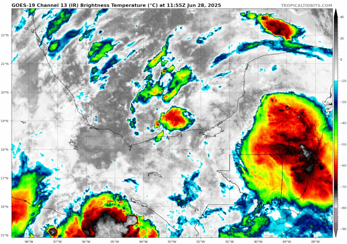
AL, 91, 2025062718, , BEST, 0, 183N, 905W, 25, 1011, DB, 34, NEQ, 0, 0, 0, 0, 1013, 160, 80, 0, 0, L, 0, , 0, 0, INVEST, S, 0, , 0, 0, 0, 0, genesis-num, 005, SPAWNINVEST, al742025 to al912025,


https://ftp.nhc.noaa.gov/atcf/btk/bal912025.dat

Image
0 likes   
Visit the Caribbean-Central America Weather Thread where you can find at first post web cams,radars
and observations from Caribbean basin members Click Here

TomballEd
Category 2
Category 2
Posts: 683
Age: 61
Joined: Wed Aug 16, 2023 4:52 pm
Location: Spring/Klein area, not Tomball

Re: ATL: INVEST 91L - Discussion

#2 Postby TomballEd » Fri Jun 27, 2025 3:39 pm

Some of the GFS and Euro ensembles spin up a weak low straight into Mexico. One (of 50) ECENS gets it over 40 knots, a named storm for sure. No where near closed off on satellite, a lemon seems about right.

If it does become a TD, it would be the first TC of the year of tropical origin. X post on Talking Tropics thread suggests well below normal instability and above normal shear in the Caribbean but perhaps the BoC isn't as hostile. CIMMS shear analysis and GFS forecast shows favorable divergence and low shear staying over Central America. But the ensemble members, while in the minority, that show development of the low must be seeing the little anticyclone getting over water.
1 likes   

User avatar
Nimbus
Category 5
Category 5
Posts: 5299
Joined: Mon Jul 19, 2004 10:54 am

Re: ATL: INVEST 91L - Discussion

#3 Postby Nimbus » Fri Jun 27, 2025 5:08 pm

There is a weak relative circulation over inland Yucatan already so after this gets out over water it should reach TD status pretty quickly.
1 likes   

Sciencerocks
Category 5
Category 5
Posts: 9152
Age: 39
Joined: Thu Jul 06, 2017 1:51 am

Re: ATL: INVEST 91L - Discussion

#4 Postby Sciencerocks » Fri Jun 27, 2025 6:17 pm

Image
0 likes   

User avatar
cycloneye
Admin
Admin
Posts: 145234
Age: 68
Joined: Thu Oct 10, 2002 10:54 am
Location: San Juan, Puerto Rico

Re: ATL: INVEST 91L - Discussion

#5 Postby cycloneye » Fri Jun 27, 2025 6:49 pm

Tropical Weather Outlook
NWS National Hurricane Center Miami FL
800 PM EDT Fri Jun 27 2025

For the North Atlantic...Caribbean Sea and the Gulf of America:

1. Yucatan Peninsula and Bay of Campeche (AL91):
A broad area of low pressure centered over the southwestern Yucatan
Peninsula of Mexico is producing a large area of disorganized
showers and thunderstorms over the Yucatan Peninsula and the
adjacent waters. This system should emerge over the Bay of Campeche
later tonight, and some development is possible on Saturday and
Sunday if the low remains over water. By Monday, this system should
move inland over eastern Mexico, ending its chances of additional
development. Regardless of development, locally heavy rains are
possible over portions of Belize, Guatemala, and southeastern
Mexico during the next few days. An Air Force Reserve Hurricane
Hunter aircraft is scheduled to investigate the system on Saturday,
if necessary.
* Formation chance through 48 hours...low...30 percent.
* Formation chance through 7 days...low...30 percent.


Forecaster Beven
0 likes   
Visit the Caribbean-Central America Weather Thread where you can find at first post web cams,radars
and observations from Caribbean basin members Click Here

User avatar
cycloneye
Admin
Admin
Posts: 145234
Age: 68
Joined: Thu Oct 10, 2002 10:54 am
Location: San Juan, Puerto Rico

Re: ATL: INVEST 91L - Discussion

#6 Postby cycloneye » Fri Jun 27, 2025 7:56 pm

Low splashing to the water.

AL, 91, 2025062800, , BEST, 0, 186N, 916W, 25, 1011, DB


Image

Image
0 likes   
Visit the Caribbean-Central America Weather Thread where you can find at first post web cams,radars
and observations from Caribbean basin members Click Here

User avatar
cycloneye
Admin
Admin
Posts: 145234
Age: 68
Joined: Thu Oct 10, 2002 10:54 am
Location: San Juan, Puerto Rico

Re: ATL: INVEST 91L - Discussion

#7 Postby cycloneye » Fri Jun 27, 2025 8:29 pm

Image
4 likes   
Visit the Caribbean-Central America Weather Thread where you can find at first post web cams,radars
and observations from Caribbean basin members Click Here

User avatar
ronjon
Category 5
Category 5
Posts: 4822
Joined: Fri Aug 19, 2005 5:17 pm
Location: Hernando Beach, FL

Re: ATL: INVEST 91L - Discussion

#8 Postby ronjon » Fri Jun 27, 2025 8:54 pm

Looks like a TD already based on radar. Could be our 2nd TS of the season.
2 likes   

Sciencerocks
Category 5
Category 5
Posts: 9152
Age: 39
Joined: Thu Jul 06, 2017 1:51 am

Re: ATL: INVEST 91L - Discussion

#9 Postby Sciencerocks » Fri Jun 27, 2025 9:19 pm

Image
0 likes   

Sciencerocks
Category 5
Category 5
Posts: 9152
Age: 39
Joined: Thu Jul 06, 2017 1:51 am

Re: ATL: INVEST 91L - Discussion

#10 Postby Sciencerocks » Sat Jun 28, 2025 12:58 am


Tropical Weather Outlook
NWS National Hurricane Center Miami FL
200 AM EDT Sat Jun 28 2025

For the North Atlantic...Caribbean Sea and the Gulf of America:

Yucatan Peninsula and Bay of Campeche (AL91):
Satellite imagery and surface observations indicate that the broad
low pressure area over the southwestern Yucatan Peninsula is
emerging over the Bay of Campeche. This system is currently
producing a large area of disorganized showers and thunderstorms
over the Yucatan Peninsula and the adjacent waters. Some
development is possible today and Sunday as the low moves generally
west-northwestward, and a tropical depression could form during
this time. By Monday, this system should move inland over eastern
Mexico, ending its chances of development. Regardless of
development, locally heavy rains are possible over portions of
Belize, Guatemala, and southeastern and eastern Mexico during the
next few days. An Air Force Reserve Hurricane Hunter aircraft is
scheduled to investigate the system later today, if necessary.
* Formation chance through 48 hours...medium...40 percent.
* Formation chance through 7 days...medium...40 percent.

$$
Forecaster Beven
0 likes   

User avatar
cycloneye
Admin
Admin
Posts: 145234
Age: 68
Joined: Thu Oct 10, 2002 10:54 am
Location: San Juan, Puerto Rico

Re: ATL: INVEST 91L - Discussion

#11 Postby cycloneye » Sat Jun 28, 2025 6:42 am

Tropical Weather Outlook
NWS National Hurricane Center Miami FL
800 AM EDT Sat Jun 28 2025

For the North Atlantic...Caribbean Sea and the Gulf of America:

1. Bay of Campeche (AL91):
An area of low pressure located in the eastern Bay of Campeche near
the Mexican coastline continues to produce a broad region of
disorganized shower and thunderstorm activity over the Yucatan
Peninsula and adjacent waters. Additional development is possible
today and Sunday as the low moves generally west-northwestward, and
a tropical depression could form during this period while the system
remains over the waters of the Bay of Campeche. By Monday, this
system should move inland over eastern Mexico, ending its chances of
development. Regardless of tropical cyclone formation, locally heavy
rains are possible over portions of Belize, Guatemala, and
southeastern Mexico during the next few days. An Air Force Reserve
Hurricane Hunter aircraft is scheduled to investigate the system
later today, if necessary.
* Formation chance through 48 hours...medium...50 percent.
* Formation chance through 7 days...medium...50 percent.


Forecaster Papin
1 likes   
Visit the Caribbean-Central America Weather Thread where you can find at first post web cams,radars
and observations from Caribbean basin members Click Here

User avatar
cycloneye
Admin
Admin
Posts: 145234
Age: 68
Joined: Thu Oct 10, 2002 10:54 am
Location: San Juan, Puerto Rico

Re: ATL: INVEST 91L - Discussion

#12 Postby cycloneye » Sat Jun 28, 2025 8:07 am

AL, 91, 2025062812, , BEST, 0, 191N, 935W, 25, 1010, DB


Image
0 likes   
Visit the Caribbean-Central America Weather Thread where you can find at first post web cams,radars
and observations from Caribbean basin members Click Here

Tailgater33
Tropical Depression
Tropical Depression
Posts: 85
Joined: Thu Jun 02, 2022 9:15 am

Re: ATL: INVEST 91L - Discussion

#13 Postby Tailgater33 » Sat Jun 28, 2025 8:24 am

Looks like our recent small B storm trend will continue ( with a few exceptions). Barry, Bill, Bob, Bret etc. in the BOC.
0 likes   

Sciencerocks
Category 5
Category 5
Posts: 9152
Age: 39
Joined: Thu Jul 06, 2017 1:51 am

Re: ATL: INVEST 91L - Discussion

#14 Postby Sciencerocks » Sat Jun 28, 2025 8:35 am

Image
0 likes   

User avatar
Hurricane2022
Category 5
Category 5
Posts: 1538
Joined: Tue Aug 23, 2022 11:38 pm
Location: Araçatuba, Brazil

Re: ATL: INVEST 91L - Discussion

#15 Postby Hurricane2022 » Sat Jun 28, 2025 9:01 am

Tailgater33 wrote:Looks like our recent small B storm trend will continue ( with a few exceptions). Barry, Bill, Bob, Bret etc. in the BOC.

Beryl also was a weak TS near/over BOC :lol:
0 likes   
Sorry for the bad English sometimes...!
For reliable and detailed information for any meteorological phenomenon, please consult the National Hurricane Center, Joint Typhoon Warning Center , or your local Meteo Center.

--------

Una cvm Christo, pro Christo, et in Christo. Sit nomen Domini benedictvm.

User avatar
Teban54
Category 5
Category 5
Posts: 3204
Joined: Sat May 19, 2018 1:19 pm

Re: ATL: INVEST 91L - Discussion

#16 Postby Teban54 » Sat Jun 28, 2025 9:02 am

Quite a nice convective blowup:

Image
1 likes   

User avatar
tropicwatch
Category 5
Category 5
Posts: 3378
Age: 61
Joined: Sat Jun 02, 2007 10:01 am
Location: Panama City Florida
Contact:

Re: ATL: INVEST 91L - Discussion

#17 Postby tropicwatch » Sat Jun 28, 2025 9:20 am

Teban54 wrote:Quite a nice convective blowup:

https://i.postimg.cc/nr01RYTX/goes19-ir-91-L-202506281155.gif


Have been watching that this morning, staying pretty persistent. 91L might be trying to put on a show for the Hurricane Hunters this afternoon. 8-)
2 likes   
Tropicwatch


Agnes 72', Eloise 75, Elena 85', Kate 85', Charley 86', Florence 88', Beryl 94', Dean 95', Erin 95', Opal 95', Earl 98', Georges 98', Ivan 2004', Arlene 2005', Dennis 2005', Ida 2009' Debby 2012' Irma 2017' Michael 2018'

User avatar
cycloneye
Admin
Admin
Posts: 145234
Age: 68
Joined: Thu Oct 10, 2002 10:54 am
Location: San Juan, Puerto Rico

Re: ATL: INVEST 91L - Discussion Update: Plane on route

#18 Postby cycloneye » Sat Jun 28, 2025 10:40 am

Yes!!!! Plane is flying!!!!
1 likes   
Visit the Caribbean-Central America Weather Thread where you can find at first post web cams,radars
and observations from Caribbean basin members Click Here

ChrisH-UK
Category 2
Category 2
Posts: 623
Joined: Sat May 29, 2021 8:22 am

Re: ATL: INVEST 91L - Discussion Update: Plane on route

#19 Postby ChrisH-UK » Sat Jun 28, 2025 10:50 am

I think this will have a good chance to become Barry why it the Bay of Campeche its notorious for spinning up storms from systems like this.
2 likes   

Sciencerocks
Category 5
Category 5
Posts: 9152
Age: 39
Joined: Thu Jul 06, 2017 1:51 am

Re: ATL: INVEST 91L - Discussion

#20 Postby Sciencerocks » Sat Jun 28, 2025 12:02 pm

Image

Broad LLC with convection over it. I wouldn't be shocked to see advisories for a PTD2 at 5pm. Probably depression or tropical storm by 5am.
1 likes   


Return to “2025”

Who is online

Users browsing this forum: No registered users and 1 guest