ATL: ANDREA - Post-Tropical - Discussion

Moderator: S2k Moderators

Message
Author
User avatar
cycloneye
Admin
Admin
Posts: 145245
Age: 68
Joined: Thu Oct 10, 2002 10:54 am
Location: San Juan, Puerto Rico

Re: ATL: INVEST 90L - Discussion

#41 Postby cycloneye » Tue Jun 24, 2025 7:32 am

Special Tropical Weather Outlook
NWS National Hurricane Center Miami FL
830 AM EDT Tue Jun 24 2025

For the North Atlantic...Caribbean Sea and the Gulf of America:

Special outlook issued to update AL90 formation chances

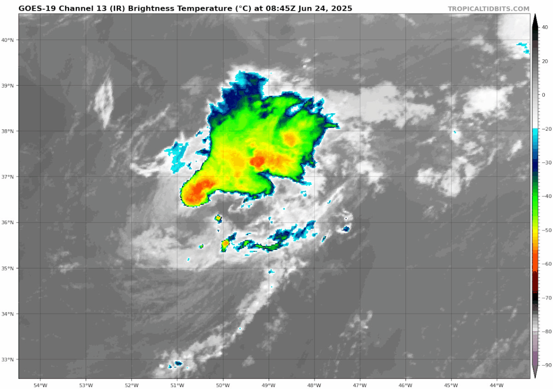
1. Central Subtropical Atlantic (AL90):
Satellite images indicate that shower and thunderstorm activity
has become better organized in association with a small gale-force
low-pressure system located about 900 miles east-northeast of
Bermuda. This system will likely become a short-lived tropical
storm later today before more hostile environmental conditions end
its opportunity for development by this evening. The low is
forecast to move northeastward at around 15 to 20 mph while
remaining over the open central Atlantic. For additional
information, including gale warnings, please see High Seas
Forecasts issued by the National Weather Service.
* Formation chance through 48 hours...high...70 percent.
* Formation chance through 7 days...high...70 percent.


High Seas Forecasts issued by the National Weather Service
can be found under AWIPS header NFDHSFAT1, WMO header FZNT01
KWBC, and online at ocean.weather.gov/shtml/NFDHSFAT1.php


Forecaster Blake


DorkyMcDorkface, those models were right.
1 likes   
Visit the Caribbean-Central America Weather Thread where you can find at first post web cams,radars
and observations from Caribbean basin members Click Here

TampaWxLurker
Tropical Depression
Tropical Depression
Posts: 99
Joined: Thu Aug 01, 2024 8:20 am

Re: ATL: INVEST 90L - Discussion

#42 Postby TampaWxLurker » Tue Jun 24, 2025 8:07 am

johngaltfla wrote:
wxman57 wrote:Appears to be merging with a front and getting sheared apart now. Good. Don't need any short-lived name. I only went 13/6/3 in the office hurricane contest. ;-)

:lol:
I can dig it.

But if a NHC staffer has 22/11/4 you know it's getting a name. 8-)


Looks like the NHC staffer might win this round )unless it totally collapses quickly.

This seems like an unusual location for cyclogenesis. Its on the absolute outer edge of supportive SST's. I know storms have formed further north and east, but this general area of the Atlantic doesn't seem to get much "traffic", at least per my amateur recollection.
Last edited by TampaWxLurker on Tue Jun 24, 2025 8:59 am, edited 1 time in total.
1 likes   

User avatar
wxman57
Moderator-Pro Met
Moderator-Pro Met
Posts: 22974
Age: 67
Joined: Sat Jun 21, 2003 8:06 pm
Location: Houston, TX (southwest)

Re: ATL: INVEST 90L - Discussion: Special Tropical Weather Outlook issued

#43 Postby wxman57 » Tue Jun 24, 2025 8:38 am

Doesn't appear to be tropical. I see forecaster Blake didn't agree with Hagen's 50%. It's 100% certain that there is a closed low and possibly 30-35kt winds. It all comes down to whether the NHC wants to identify the low as a STS or STD before it's torn apart by shear today.
0 likes   

User avatar
cycloneye
Admin
Admin
Posts: 145245
Age: 68
Joined: Thu Oct 10, 2002 10:54 am
Location: San Juan, Puerto Rico

Re: ATL: INVEST 90L - Discussion: Special Tropical Weather Outlook issued

#44 Postby cycloneye » Tue Jun 24, 2025 8:51 am

0 likes   
Visit the Caribbean-Central America Weather Thread where you can find at first post web cams,radars
and observations from Caribbean basin members Click Here

User avatar
Teban54
Category 5
Category 5
Posts: 3204
Joined: Sat May 19, 2018 1:19 pm

Re: ATL: INVEST 90L - Discussion: Special Tropical Weather Outlook issued

#45 Postby Teban54 » Tue Jun 24, 2025 8:57 am

Right after the special TWO, poof :lol:

Image
1 likes   

TampaWxLurker
Tropical Depression
Tropical Depression
Posts: 99
Joined: Thu Aug 01, 2024 8:20 am

Re: ATL: INVEST 90L - Discussion

#46 Postby TampaWxLurker » Tue Jun 24, 2025 8:59 am

Double-post.
Last edited by TampaWxLurker on Tue Jun 24, 2025 9:26 am, edited 1 time in total.
0 likes   

User avatar
cycloneye
Admin
Admin
Posts: 145245
Age: 68
Joined: Thu Oct 10, 2002 10:54 am
Location: San Juan, Puerto Rico

Re: ATL: INVEST 90L - Discussion: Special Tropical Weather Outlook issued

#47 Postby cycloneye » Tue Jun 24, 2025 9:08 am

0 likes   
Visit the Caribbean-Central America Weather Thread where you can find at first post web cams,radars
and observations from Caribbean basin members Click Here

Sciencerocks
Category 5
Category 5
Posts: 9152
Age: 39
Joined: Thu Jul 06, 2017 1:51 am

Re: ATL: ANDREA - Tropical Storm - Discussion

#48 Postby Sciencerocks » Tue Jun 24, 2025 9:14 am

Should have done so 30 hours ago! But I think they're doing it because they're going to extend the time back to that point post season and wanted to give it a name.
1 likes   

User avatar
cycloneye
Admin
Admin
Posts: 145245
Age: 68
Joined: Thu Oct 10, 2002 10:54 am
Location: San Juan, Puerto Rico

Re: ATL: ANDREA - Tropical Storm - Discussion

#49 Postby cycloneye » Tue Jun 24, 2025 9:44 am

1 likes   
Visit the Caribbean-Central America Weather Thread where you can find at first post web cams,radars
and observations from Caribbean basin members Click Here

Sciencerocks
Category 5
Category 5
Posts: 9152
Age: 39
Joined: Thu Jul 06, 2017 1:51 am

Re: ATL: ANDREA - Tropical Storm - Discussion

#50 Postby Sciencerocks » Tue Jun 24, 2025 9:48 am

Image
0 likes   

LarryWx
S2K Supporter
S2K Supporter
Posts: 6296
Joined: Sun Sep 07, 2003 2:04 pm
Location: GA

Re: ATL: INVEST 90L - Discussion: Special Tropical Weather Outlook issued

#51 Postby LarryWx » Tue Jun 24, 2025 10:00 am

Teban54 wrote:Right after the special TWO, poof :lol:

[url]https://i.postimg.cc/mk416sX3/goes19-ir-90-L-202506240845.gif [/url]


This is about as textbook a ham sandwich as they come! :lol:
1 likes   
Personal Forecast Disclaimer:
The posts in this forum are NOT official forecasts and should not be used as such. They are just the opinion of the poster and may or may not be backed by sound meteorological data. They are NOT endorsed by any professional institution or storm2k.org. For official information, please refer to the NHC and NWS products.

User avatar
cycloneye
Admin
Admin
Posts: 145245
Age: 68
Joined: Thu Oct 10, 2002 10:54 am
Location: San Juan, Puerto Rico

Re: ATL: INVEST 90L - Discussion: Special Tropical Weather Outlook issued

#52 Postby cycloneye » Tue Jun 24, 2025 10:04 am

LarryWx wrote:
Teban54 wrote:Right after the special TWO, poof :lol:

[url]https://i.postimg.cc/mk416sX3/goes19-ir-90-L-202506240845.gif [/url]


This is about as textbook a ham sandwich as they come! :lol:


For sure at post-season TCR, they add time as a storm as IMO, it has been a TS since 24 to 36 hours prior to advisory.
2 likes   
Visit the Caribbean-Central America Weather Thread where you can find at first post web cams,radars
and observations from Caribbean basin members Click Here

User avatar
MGC
S2K Supporter
S2K Supporter
Posts: 5896
Joined: Sun Mar 23, 2003 9:05 pm
Location: Pass Christian MS, or what is left.

Re: NATL: ANDREA - Tropical Storm - Discussion

#53 Postby MGC » Tue Jun 24, 2025 10:07 am

System looked better yesterday, as all my tropical troubles were so far away.......MGC
2 likes   

TomballEd
Category 2
Category 2
Posts: 683
Age: 61
Joined: Wed Aug 16, 2023 4:52 pm
Location: Spring/Klein area, not Tomball

Re: ATL: ANDREA - Tropical Storm - Discussion

#54 Postby TomballEd » Tue Jun 24, 2025 10:26 am


The very definition of a name waster. It looked better yesterday and might have gotten a post-season upgrade but this will be a 2 advisories and done special.
0 likes   

User avatar
cycloneye
Admin
Admin
Posts: 145245
Age: 68
Joined: Thu Oct 10, 2002 10:54 am
Location: San Juan, Puerto Rico

Re: NATL: ANDREA - Tropical Storm - Discussion

#55 Postby cycloneye » Tue Jun 24, 2025 10:40 am

0 likes   
Visit the Caribbean-Central America Weather Thread where you can find at first post web cams,radars
and observations from Caribbean basin members Click Here

User avatar
chaser1
S2K Supporter
S2K Supporter
Posts: 5463
Age: 64
Joined: Sat Oct 15, 2005 5:59 pm
Location: Longwood, Fl

Re: ATL: INVEST 90L - Discussion: Special Tropical Weather Outlook issued

#56 Postby chaser1 » Tue Jun 24, 2025 10:45 am

LarryWx wrote:
Teban54 wrote:Right after the special TWO, poof :lol:

[url]https://i.postimg.cc/mk416sX3/goes19-ir-90-L-202506240845.gif [/url]


This is about as textbook a ham sandwich as they come! :lol:


I couldn't agree more :roll: That's okay though, I was only expecting 13 or 14 Atlantic named storms this year but my S2K Hurricane Season pole prediction was 15/7/2 for this very reason. For many years now, I simply view most Atlantic seasons with an anticipation of one or two fluff-balls being baked into the mix :cheesy:
2 likes   
Andy D

(For official information, please refer to the NHC and NWS products.)

User avatar
cycloneye
Admin
Admin
Posts: 145245
Age: 68
Joined: Thu Oct 10, 2002 10:54 am
Location: San Juan, Puerto Rico

Re: ATL: ANDREA - Tropical Storm - Discussion

#57 Postby cycloneye » Tue Jun 24, 2025 10:56 am

The most east location of formation, but as I mentioned before, for sure they will extend it's life 24-36 hours at post-season TCR.

 https://x.com/ZachCoveyTV/status/1937539538181579045

2 likes   
Visit the Caribbean-Central America Weather Thread where you can find at first post web cams,radars
and observations from Caribbean basin members Click Here

User avatar
AnnularCane
S2K Supporter
S2K Supporter
Posts: 2859
Joined: Thu Jun 08, 2006 9:18 am
Location: Wytheville, VA

Re: ATL: ANDREA - Tropical Storm - Discussion

#58 Postby AnnularCane » Tue Jun 24, 2025 11:04 am

Gotta hand it to her though, I never thought she'd be upgraded. She really wanted it! 8-)
1 likes   
"But it never rained rain. It never snowed snow. And it never blew just wind. It rained things like soup and juice. It snowed mashed potatoes and green peas. And sometimes the wind blew in storms of hamburgers." -- Judi Barrett, Cloudy with a Chance of Meatballs

psyclone
S2K Supporter
S2K Supporter
Posts: 4760
Joined: Wed Aug 24, 2005 9:04 pm
Location: palm harbor fl

Re: ATL: ANDREA - Tropical Storm - Discussion

#59 Postby psyclone » Tue Jun 24, 2025 11:25 am

I thought a system needed clouds for a name. oh my. give it another 50 days or so and we may have something
0 likes   

User avatar
DorkyMcDorkface
Category 3
Category 3
Posts: 887
Age: 27
Joined: Mon Sep 30, 2019 1:32 pm
Location: Mid-Atlantic

Re: ATL: ANDREA - Tropical Storm - Discussion

#60 Postby DorkyMcDorkface » Tue Jun 24, 2025 12:50 pm

Sciencerocks wrote:Should have done so 30 hours ago! But I think they're doing it because they're going to extend the time back to that point post season and wanted to give it a name.

Yeah I'm inclined to believe that as well. This has arguably been a TC since Sunday night or so. We already knew it had a solid LLC and there's been periods of sustained convection up until recently.
5 likes   
Please note the thougths expressed by this account are solely those of the user and are from a hobbyist perspective. For more comprehensive analysis, consult an actual professional meteorologist or meteorology agency.


Floyd 1999 | Isabel 2003 | Hanna 2008 | Irene 2011 | Sandy 2012 | Isaias 2020


Return to “2025”

Who is online

Users browsing this forum: No registered users and 6 guests