
EPAC: ERICK - Post-Tropical - Discussion
Moderator: S2k Moderators
-
Hurricane2022

- Category 5

- Posts: 2096
- Joined: Tue Aug 23, 2022 11:38 pm
- Location: Araçatuba, Brazil
Re: EPAC: ERICK - Hurricane - Discussion
Last edited by Hurricane2022 on Wed Jun 18, 2025 10:58 pm, edited 1 time in total.
1 likes
Sorry for the bad English sometimes...!
For reliable and detailed information for any meteorological phenomenon, please consult the National Hurricane Center, Joint Typhoon Warning Center , or your local Meteo Center.
--------
ECCE OMNIA NOVA FACIAM (Ap 21,5).
For reliable and detailed information for any meteorological phenomenon, please consult the National Hurricane Center, Joint Typhoon Warning Center , or your local Meteo Center.
--------
ECCE OMNIA NOVA FACIAM (Ap 21,5).
-
cycloneye

- Admin

- Posts: 149817
- Age: 69
- Joined: Thu Oct 10, 2002 10:54 am
- Location: San Juan, Puerto Rico
Re: EPAC: ERICK - Hurricane - Discussion
0 likes
Visit the Caribbean-Central America Weather Thread where you can find at first post web cams,radars
and observations from Caribbean basin members Click Here
and observations from Caribbean basin members Click Here

Re: EPAC: ERICK - Hurricane - Discussion
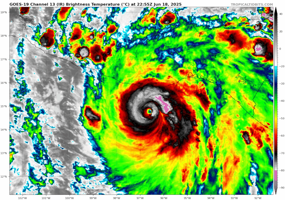
Hmm, what's with the huge convective blob to the SW?
0 likes
TC naming lists: retirements and intensity
Most aggressive Advisory #1's in North Atlantic (cr. kevin for starting the list)
Most aggressive Advisory #1's in North Atlantic (cr. kevin for starting the list)
-
REDHurricane

- Category 1

- Posts: 438
- Age: 28
- Joined: Sun Jul 03, 2022 2:36 pm
- Location: Northeast Pacific Ocean
Re: EPAC: ERICK - Hurricane - Discussion
Teban54 wrote:Hmm, what's with the huge convective blob to the SW?
https://i.postimg.cc/brqGH999/goes19-ir-05-E-202506182255.gif
EWRC attempt maybe?
0 likes
-
Sciencerocks
- Category 5
- Posts: 10194
- Age: 40
- Joined: Thu Jul 06, 2017 1:51 am
Re: EPAC: ERICK - Hurricane - Discussion
REDHurricane wrote:Teban54 wrote:Hmm, what's with the huge convective blob to the SW?
https://i.postimg.cc/brqGH999/goes19-ir-05-E-202506182255.gif
EWRC attempt maybe?
Downslopping winds off land drawing in dry air. It is possible that it could be forcing outter eye walls bands that steal energy from the core.
Dry air as air sinks from off land....
Hurricane Kenna in 2002 did exactly this as it was within 12 hours of landfall.
If it is a weak and broad system then land can tighten it up by decreasing the area which creates convergence of the air parcels. Less area = more energy close to each other forcing the air to rise to its dew point. The thing about hurricanes of great strength hitting land with higher mountains is they will pull the air off them and that air will decrease and lose energy(or laten heat) and also dry up. (Increases area and the molecules don't hit each other as much and the column of air loses energy and sinks)This my friends creates outer bands and can start ewrc's and messes with the convergence that moves the air from the surface upwards that powers the storm.
Last edited by Sciencerocks on Wed Jun 18, 2025 11:39 pm, edited 2 times in total.
2 likes
-
weeniepatrol

- Category 5
- Posts: 1345
- Joined: Sat Aug 22, 2020 5:30 pm
- Location: WA State

Re: EPAC: ERICK - Hurricane - Discussion
WTPZ65 KNHC 190540
TCUEP5
Hurricane Erick Tropical Cyclone Update
NWS National Hurricane Center Miami FL EP052025
1140 PM CST Wed Jun 18 2025
...ERICK STRENGTHENS INTO A CATEGORY FOUR MAJOR HURRICANE...
Satellite imagery indicates Erick has strengthened into a category
four major hurricane with estimated maximum sustained winds of 145
mph (230 km/h). A special advisory will be issued around 0600 UTC
in lieu of an intermediate advisory.
Forecaster Kelly
4 likes
Re: EPAC: ERICK - Hurricane - Discussion
WTPZ45 KNHC 190544
TCDEP5
Hurricane Erick Special Discussion Number 11
NWS National Hurricane Center Miami FL EP052025
1200 AM CST Thu Jun 19 2025
This is a special advisory mainly to update the intensity of Erick.
After an earlier eyewall replacement, satellite images indicate
very deep convection is wrapping around the eye of the hurricane.
Using a blend of objective ADT Dvorak estimates and SATCON values
from UW/CIMSS yields a current intensity estimate of 125 kt, which
is used for this advisory. Some additional strengthening is
possible during the next couple of hours, although the interaction
with land should halt the intensification process. Erick will
weaken rapidly after making landfall.
A slight leftward adjustment was made to the forecast track based
on the recent motion, which is now 305/8 kt.
This special advisory is being issued in lieu of the 06Z
intermediate advisory.
KEY MESSAGES:
1. Erick is now an extremely dangerous category 4 hurricane, and
devastating wind damage is likely where the core moves onshore.
Weather conditions are already deteriorating in the warning area,
and preparations to protect life and property should have been
completed.
2. Erick will produce heavy rainfall across portions of Central
America and Southwest Mexico through this week. Life-threatening
flooding and mudslides are likely, especially in areas of steep
terrain.
3. A dangerous, life-threatening storm surge is expected to produce
coastal flooding near and to the east of where the center crosses
the coast, in areas of onshore winds. The surge will be accompanied
by large and destructive waves.
FORECAST POSITIONS AND MAX WINDS
INIT 19/0600Z 15.5N 97.5W 125 KT 145 MPH
12H 19/1200Z 16.2N 98.0W 95 KT 110 MPH...INLAND
24H 20/0000Z 17.4N 99.1W 35 KT 40 MPH...INLAND
36H 20/1200Z...DISSIPATED
$$
Forecaster Pasch
2 likes
-
Sciencerocks
- Category 5
- Posts: 10194
- Age: 40
- Joined: Thu Jul 06, 2017 1:51 am

-
bob rulz
- Category 5
- Posts: 1711
- Age: 36
- Joined: Sat Jan 28, 2006 7:30 pm
- Location: Salt Lake City, Utah
Re: EPAC: ERICK - Hurricane - Discussion
Been periodically checking the NHC website but first time popping onto the forum this season. The EPAC seems to be off to a crazy start this season and to have another rapidly deepening hurricane of this magnitude in this area is crazy and sad to see. I'm assuming Acapulco has still not recovered from Otis. Hopefully this hits along the sparsely populated portion of the coast to the east.
3 likes
-
cheezyWXguy

- Category 5
- Posts: 6284
- Joined: Mon Feb 13, 2006 12:29 am
- Location: Dallas, TX
Re: EPAC: ERICK - Hurricane - Discussion
Judging by satellite imagery Erick may be resuming strengthening in its final hours before landfall. That persistent blob to the southwest has dissipated, the cdo is cooling and the eye is starting to warm again.
1 likes


Re: EPAC: ERICK - Hurricane - Discussion
Honestly thought land interaction would cause Erick to weaken somewhat as it moves west along the coast like what happened with Pauline in 1997.
Guess it is intensification all the way to landfall.
Guess it is intensification all the way to landfall.
1 likes
-
MarioProtVI
- Category 5
- Posts: 1039
- Age: 24
- Joined: Sun Sep 29, 2019 7:33 pm
- Location: New Jersey
Re: EPAC: ERICK - Hurricane - Discussion
This is at least 20 kt too high. Not sure how Erick’s current appearance translates to ADT T6.5.
1 likes
-
Kingarabian

- S2K Supporter

- Posts: 16383
- Joined: Sat Aug 08, 2009 3:06 am
- Location: Honolulu, Hawaii
Re: EPAC: ERICK - Hurricane - Discussion
MarioProtVI wrote:This is at least 20 kt too high. Not sure how Erick’s current appearance translates to ADT T6.5.
Easily supports T6.5. Current BD imagery supports that in accordance to the Dvorak Technique manual.
1 likes
RIP Kobe Bryant
-
DorkyMcDorkface

- Category 5
- Posts: 1063
- Age: 28
- Joined: Mon Sep 30, 2019 1:32 pm
- Location: Mid-Atlantic
Re: EPAC: ERICK - Hurricane - Discussion
weeniepatrol wrote:Almost certainly robbed of Cat 4 designation
Not quite
2 likes
Please note the thoughts expressed by this account are solely those of the user and are from a hobbyist perspective. For more comprehensive analysis, consult an actual professional meteorologist or meteorological agency.
Floyd 1999 | Isabel 2003 | Hanna 2008 | Irene 2011 | Sandy 2012 | Isaias 2020
-
weeniepatrol
- Category 5
- Posts: 1345
- Joined: Sat Aug 22, 2020 5:30 pm
- Location: WA State
Re: EPAC: ERICK - Hurricane - Discussion
DorkyMcDorkface wrote:weeniepatrol wrote:Almost certainly robbed of Cat 4 designation
Not quite
Thank god. Was scared they would hold at 110 kt given satellite
1 likes

Re: EPAC: ERICK - Hurricane - Discussion
As far as I could see there aren't any big population centers at Erick's landfall point. However, smaller villages such as Corralero & Collantes will be directly impacted. While they only have a few thousand inhabitants, they are pretty much at sea-level and have never experienced a MH landfall. Besides perhaps hurricane Pauline in 1997 for some parts of the region. That hurricane also resulted in 230 - 500 deadly casualties despite landing in a similarly sparsely populated region. Let's hope this one falls apart fast and doesn't cause that much destruction.
0 likes
Re: EPAC: ERICK - Hurricane - Discussion
Raw T# flips between 5.3 - 5.4 and 6.4 - 6.9 depending on whether the automated Dvorak gets the center right. Tbh a bit surprised that Dvorak likes this so much despite its very ragged appearance atm. I guess the very cold CDO (-75C) makes up for the poorly defined eye.
Last edited by kevin on Thu Jun 19, 2025 3:55 am, edited 1 time in total.
1 likes
Re: EPAC: ERICK - Hurricane - Discussion
Accidental double post.
Last edited by kevin on Thu Jun 19, 2025 3:55 am, edited 1 time in total.
0 likes
-
cycloneye
- Admin
- Posts: 149817
- Age: 69
- Joined: Thu Oct 10, 2002 10:54 am
- Location: San Juan, Puerto Rico
Re: EPAC: ERICK - Hurricane - Discussion
BULLETIN
Hurricane Erick Advisory Number 12
NWS National Hurricane Center Miami FL EP052025
300 AM CST Thu Jun 19 2025
...ERICK VERY NEAR THE COAST OF MEXICO...
...BRINGING EXTREMELY DESTRUCTIVE WINDS NEAR ITS CORE...
SUMMARY OF 300 AM CST...0900 UTC...INFORMATION
----------------------------------------------
LOCATION...15.9N 97.9W
ABOUT 55 MI...85 KM ESE OF PUNTA MALDONADO MEXICO
MAXIMUM SUSTAINED WINDS...140 MPH...220 KM/H
PRESENT MOVEMENT...NW OR 310 DEGREES AT 9 MPH...15 KM/H
MINIMUM CENTRAL PRESSURE...940 MB...27.76 INCHES
Hurricane Erick Discussion Number 12
NWS National Hurricane Center Miami FL EP052025
300 AM CST Thu Jun 19 2025
Erick is about to make landfall along the southern coast of Mexico.
Its rapid strengthening episode has ended, likely due to the
interaction with land. The eye has become obscured on satellite
imagery, and the intensity is adjusted to 120 kt in agreement with
the latest objective estimates from UW/CIMSS. Erick remains an
extremely dangerous category 4 hurricane. However, rapid weakening
will occur after the center moves inland and the system moves over
the mountainous terrain of Mexico.
Smoothing out the trochoidal wobbles in the track, the motion
estimate, 310/8 kt, remains about the same as before. This general
motion, on the south side of a weak mid-level ridge, is likely to
continue until the system dissipates within the next day or two.
The official track forecast is just slightly west of the previous
one and close to the latest corrected consensus, HCCA, guidance.
KEY MESSAGES:
1. Erick is an extremely dangerous category 4 hurricane, and
devastating wind damage is likely near its core. Take shelter in
the interior portion of a well-built structure and remain sheltered
until after hazardous conditions pass.
2. Erick will produce heavy rainfall across portions of Southwest
Mexico through this week. Life-threatening flooding and mudslides
are likely, especially in areas of steep terrain.
3. A dangerous, life-threatening storm surge is expected to produce
coastal flooding near and to the east of where the center crosses
the coast, in areas of onshore winds. The surge will be accompanied
by large and destructive waves.
FORECAST POSITIONS AND MAX WINDS
INIT 19/0900Z 15.9N 97.9W 120 KT 140 MPH
12H 19/1800Z 16.7N 98.9W 80 KT 90 MPH...INLAND
24H 20/0600Z 17.5N 99.8W 30 KT 35 MPH...INLAND
36H 20/1800Z...DISSIPATED
$$
Forecaster Pasch
2 likes
Visit the Caribbean-Central America Weather Thread where you can find at first post web cams,radars
and observations from Caribbean basin members Click Here
and observations from Caribbean basin members Click Here
Who is online
Users browsing this forum: No registered users and 39 guests