EPAC: ERICK - Post-Tropical - Discussion
Moderator: S2k Moderators
-
Yellow Evan

- Professional-Met

- Posts: 16231
- Age: 27
- Joined: Fri Jul 15, 2011 12:48 pm
- Location: Henderson, Nevada/Honolulu, HI
- Contact:
Re: EPAC: ERICK - Hurricane - Discussion Update=Major hurricane=120 mph
Strongest quad has yet to be sampled. However, I wouldn’t expect intensification until the inner eyewall dies down and we are running out of time.
1 likes
-
Sciencerocks
- Category 5

- Posts: 10181
- Age: 40
- Joined: Thu Jul 06, 2017 1:51 am

-
cycloneye

- Admin

- Posts: 149275
- Age: 69
- Joined: Thu Oct 10, 2002 10:54 am
- Location: San Juan, Puerto Rico
Re: EPAC: ERICK - Hurricane - Discussion
0 likes
Visit the Caribbean-Central America Weather Thread where you can find at first post web cams,radars
and observations from Caribbean basin members Click Here
and observations from Caribbean basin members Click Here
-
cycloneye
- Admin
- Posts: 149275
- Age: 69
- Joined: Thu Oct 10, 2002 10:54 am
- Location: San Juan, Puerto Rico
Re: EPAC: ERICK - Hurricane - Discussion
Yikes.

1 likes
Visit the Caribbean-Central America Weather Thread where you can find at first post web cams,radars
and observations from Caribbean basin members Click Here
and observations from Caribbean basin members Click Here

Re: EPAC: ERICK - Hurricane - Discussion
So much for EWRC weakening, I guess
3 likes
TC naming lists: retirements and intensity
Most aggressive Advisory #1's in North Atlantic (cr. kevin for starting the list)
Most aggressive Advisory #1's in North Atlantic (cr. kevin for starting the list)
-
Category5Kaiju

- Category 5
- Posts: 4331
- Joined: Thu Dec 24, 2020 12:45 pm
- Location: Seattle and Phoenix
Re: EPAC: ERICK - Hurricane - Discussion
Yeah...um...I think there's a rather high possibility that this storm is going to make landfall at Category 4 strength. Very dangerous situation unfolding for the same areas that were devastated by Otis and John, unfortunately.
1 likes
Unless explicitly stated, all info in my posts is based on my own opinions and observations. Tropical storms and hurricanes can be extremely dangerous. Refer to an accredited weather research agency or meteorologist if you need to make serious decisions regarding an approaching storm.

Re: EPAC: ERICK - Hurricane - Discussion
So uh, what happened to the recon data? Is this common?
0 likes
-
Yellow Evan
- Professional-Met
- Posts: 16231
- Age: 27
- Joined: Fri Jul 15, 2011 12:48 pm
- Location: Henderson, Nevada/Honolulu, HI
- Contact:
Re: EPAC: ERICK - Hurricane - Discussion
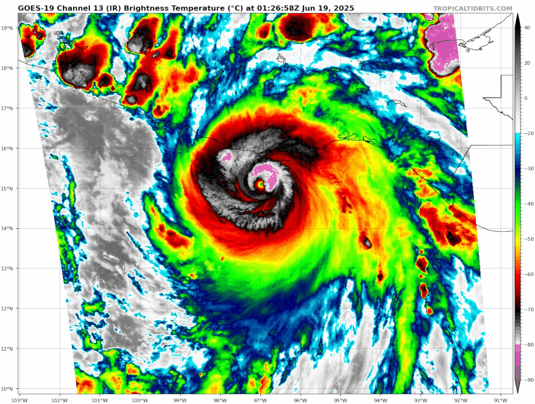
Outer eyewall almost certainly eroded by land interaction. Northern inner eyewall does appear drastically more vigorous than earlier but I’m not sure if it’s as strong as Dvorak color scale would normally suggest.
1 likes
-
cycloneye
- Admin
- Posts: 149275
- Age: 69
- Joined: Thu Oct 10, 2002 10:54 am
- Location: San Juan, Puerto Rico
Re: EPAC: ERICK - Hurricane - Discussion
1 likes
Visit the Caribbean-Central America Weather Thread where you can find at first post web cams,radars
and observations from Caribbean basin members Click Here
and observations from Caribbean basin members Click Here
-
Kingarabian

- S2K Supporter

- Posts: 16348
- Joined: Sat Aug 08, 2009 3:06 am
- Location: Honolulu, Hawaii


Re: EPAC: ERICK - Hurricane - Discussion
Kingarabian wrote:CDG trying to wrap around the eye.
Deja vu coming into the coast.
2 likes
The above post and any post by Ntxw is NOT an official forecast and should not be used as such. It is just the opinion of the poster and may or may not be backed by sound meteorological data. It is NOT endorsed by any professional institution including Storm2k. For official information, please refer to NWS products.
Help support Storm2K!

-
cycloneye
- Admin
- Posts: 149275
- Age: 69
- Joined: Thu Oct 10, 2002 10:54 am
- Location: San Juan, Puerto Rico
Re: EPAC: ERICK - Hurricane - Discussion
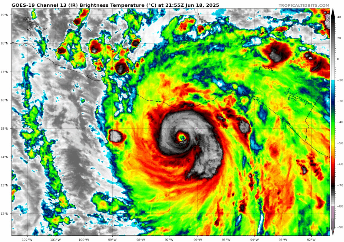
BULLETIN
Hurricane Erick Advisory Number 10
NWS National Hurricane Center Miami FL EP052025
900 PM CST Wed Jun 18 2025
...MAJOR HURRICANE ERICK HEADING FOR THE COAST OF MEXICO...
...EXPECTED TO BRING DESTRUCTIVE WINDS AND LIFE-THREATENING FLASH
FLOODS TO PORTIONS OF SOUTHERN MEXICO LATE TONIGHT AND THURSDAY...
SUMMARY OF 900 PM CST...0300 UTC...INFORMATION
----------------------------------------------
LOCATION...15.2N 97.1W
ABOUT 55 MI...85 KM SW OF PUERTO ANGEL MEXICO
ABOUT 125 MI...200 KM SE OF PUNTA MALDONADO MEXICO
MAXIMUM SUSTAINED WINDS...125 MPH...205 KM/H
PRESENT MOVEMENT...NW OR 320 DEGREES AT 9 MPH...15 KM/H
MINIMUM CENTRAL PRESSURE...950 MB...28.06 INCHES
Hurricane Erick Discussion Number 10
NWS National Hurricane Center Miami FL EP052025
900 PM CST Wed Jun 18 2025
Erick's rapid intensification continued through 18/23Z. as an Air
Force Reserve Hurricane Hunter aircraft near that time reported
that the central pressure had fallen to 953 mb. However, since
that time, the satellite appearance of the hurricane went through
a period when it was a little degraded, suggesting that the
intensification rate may have slowed. This may be due to an
attempted eyewall replacement cycle, as the aircraft data suggested
concentric wind maxima during its pass through the center. The
intensity is a little uncertain, as the plane had to abort due to
computer problems before it could probe the northeastern eyewall.
Based on the central pressure, the observed wind structure, and the
various satellite intensity estimates, the initial intensity is set
to a possibly conservative 110 kt.
The initial motion estimate is northwestward at 320/8 kt. This
motion should bring the center to the Mexican coast in the state of
Oaxaca within the next 12 h, with a subsequent northwestward motion
bringing the system farther inland over southern Mexico on Thursday
and Thursday night. The forecast guidance is essentially the same
as for the previous advisory, and the new forecast track has a
slight nudge to the right based on the current location and motion.
Conditions continue to be favorable for strengthening, and it is
possible that Erick could get stronger before landfall if the
possible eyewall replacement completes. Regardless of additional
intensification, rapid weakening is expected after landfall, and
Erick is expected to dissipate over southern Mexico Thursday night
or Friday.
KEY MESSAGES:
1. Erick continues to intensify and is now a major hurricane. It
is expected to be a major hurricane when it reaches the coast of
Mexico in the western portion of the state of Oaxaca or the eastern
portion of the state of Guerrero within the hurricane warning area
early Thursday. Devastating wind damage is possible where the core
of the storm moves onshore. Weather conditions are already
deteriorating, and preparations to protect life and property should
be rushed to completion.
2. Erick will produce heavy rainfall across portions of Central
America and Southwest Mexico through this week. Life-threatening
flooding and mudslides are likely, especially in areas of steep
terrain.
3. A dangerous, life-threatening storm surge is expected to produce
coastal flooding near and to the east of where the center crosses
the coast, in areas of onshore winds. The surge will be accompanied
by large and destructive waves.
FORECAST POSITIONS AND MAX WINDS
INIT 19/0300Z 15.2N 97.1W 110 KT 125 MPH
12H 19/1200Z 16.2N 97.8W 85 KT 100 MPH...INLAND
24H 20/0000Z 17.8N 99.1W 30 KT 35 MPH...INLAND
36H 20/1200Z...DISSIPATED
$$
Forecaster Beven
0 likes
Visit the Caribbean-Central America Weather Thread where you can find at first post web cams,radars
and observations from Caribbean basin members Click Here
and observations from Caribbean basin members Click Here
-
cycloneye
- Admin
- Posts: 149275
- Age: 69
- Joined: Thu Oct 10, 2002 10:54 am
- Location: San Juan, Puerto Rico
Re: EPAC: ERICK - Hurricane - Discussion
Now we know what happened to the plane.
The
intensity is a little uncertain, as the plane had to abort due to
computer problems before it could probe the northeastern eyewall
intensity is a little uncertain, as the plane had to abort due to
computer problems before it could probe the northeastern eyewall
1 likes
Visit the Caribbean-Central America Weather Thread where you can find at first post web cams,radars
and observations from Caribbean basin members Click Here
and observations from Caribbean basin members Click Here
-
Yellow Evan
- Professional-Met
- Posts: 16231
- Age: 27
- Joined: Fri Jul 15, 2011 12:48 pm
- Location: Henderson, Nevada/Honolulu, HI
- Contact:
Re: EPAC: ERICK - Hurricane - Discussion
I wouldn't be surprised if the southern outer eyewall has erroded completely given how vigorous convection is wrapping around the inner eyewall now.
1 likes
Re: EPAC: ERICK - Hurricane - Discussion
1 likes
TC naming lists: retirements and intensity
Most aggressive Advisory #1's in North Atlantic (cr. kevin for starting the list)
Most aggressive Advisory #1's in North Atlantic (cr. kevin for starting the list)
-
Yellow Evan
- Professional-Met
- Posts: 16231
- Age: 27
- Joined: Fri Jul 15, 2011 12:48 pm
- Location: Henderson, Nevada/Honolulu, HI
- Contact:

-
Hurricane2022

- Category 5
- Posts: 2016
- Joined: Tue Aug 23, 2022 11:38 pm
- Location: Araçatuba, Brazil
Re: EPAC: ERICK - Hurricane - Discussion
Big wobble to the west, Acapulco may be in trouble right now
0 likes
Sorry for the bad English sometimes...!
For reliable and detailed information for any meteorological phenomenon, please consult the National Hurricane Center, Joint Typhoon Warning Center , or your local Meteo Center.
--------
ECCE OMNIA NOVA FACIAM (Ap 21,5).
For reliable and detailed information for any meteorological phenomenon, please consult the National Hurricane Center, Joint Typhoon Warning Center , or your local Meteo Center.
--------
ECCE OMNIA NOVA FACIAM (Ap 21,5).
-
galaxy401

- Category 5
- Posts: 2446
- Age: 30
- Joined: Sat Aug 25, 2012 9:04 pm
- Location: Casa Grande, Arizona
Re: EPAC: ERICK - Hurricane - Discussion
Almost looks like it's moving parallel to the coast.
0 likes
Got my eyes on moving right into Hurricane Alley: Florida.
-
cheezyWXguy

- Category 5
- Posts: 6281
- Joined: Mon Feb 13, 2006 12:29 am
- Location: Dallas, TX
EPAC: ERICK - Recon
I’m not sure that the ewrc has been halted. Or, maybe nearby land is having an impact on more than just the outer eyewall? The inner eye is becoming more cloud filled and that persistent blob on the southwest side suggests some kind of structural changes are still underway. If so, intensity is most likely leveling off, at least for the moment.
2 likes
Who is online
Users browsing this forum: No registered users and 134 guests