EPAC: ERICK - Post-Tropical - Discussion
Moderator: S2k Moderators
-
ColdMiser123

- Professional-Met

- Posts: 905
- Age: 29
- Joined: Mon Sep 26, 2016 3:26 pm
- Location: Northeast US
Re: EPAC: ERICK - Hurricane - Discussion
The CDO is not fully symmetric - so the center should wobble both to the north & to the west due to the mass imbalance.
0 likes
B.S., M.S., Meteorology & Atmospheric Science
-
cycloneye

- Admin

- Posts: 149816
- Age: 69
- Joined: Thu Oct 10, 2002 10:54 am
- Location: San Juan, Puerto Rico
Re: EPAC: ERICK - Hurricane - Discussion
BULLETIN
Hurricane Erick Advisory Number 9
NWS National Hurricane Center Miami FL EP052025
300 PM CST Wed Jun 18 2025
...DANGEROUS ERICK FORECAST TO BECOME A MAJOR HURRICANE BY
TONIGHT...
...EXPECTED TO BRING POTENTIALLY DESTRUCTIVE WINDS AND
LIFE-THREATENING FLASH FLOODS TO PORTIONS OF SOUTHERN MEXICO LATE
TONIGHT AND THURSDAY...
SUMMARY OF 300 PM CST...2100 UTC...INFORMATION
----------------------------------------------
LOCATION...14.5N 96.5W
ABOUT 85 MI...135 KM S OF PUERTO ANGEL MEXICO
ABOUT 185 MI...300 KM SE OF PUNTA MALDONADO MEXICO
MAXIMUM SUSTAINED WINDS...110 MPH...175 KM/H
PRESENT MOVEMENT...NW OR 315 DEGREES AT 9 MPH...15 KM/H
MINIMUM CENTRAL PRESSURE...967 MB...28.56 INCHES
Hurricane Erick Discussion Number 9
NWS National Hurricane Center Miami FL EP052025
300 PM CST Wed Jun 18 2025
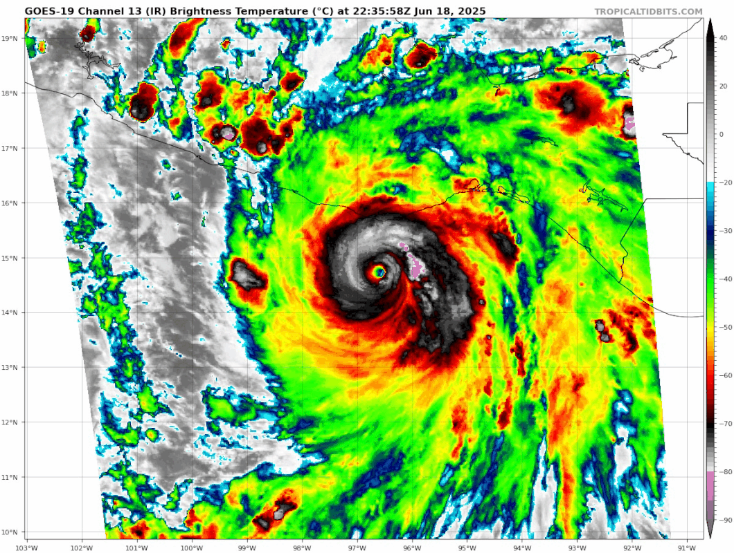
An Air Force Reconnaissance aircraft completed its mission into
Erick this morning and found 93-kt flight-level winds at 700 mb
along with a dropsonde central pressure of 971 mb around 17Z. The
recon data showed strengthening in between the 1530Z fix and the 17Z
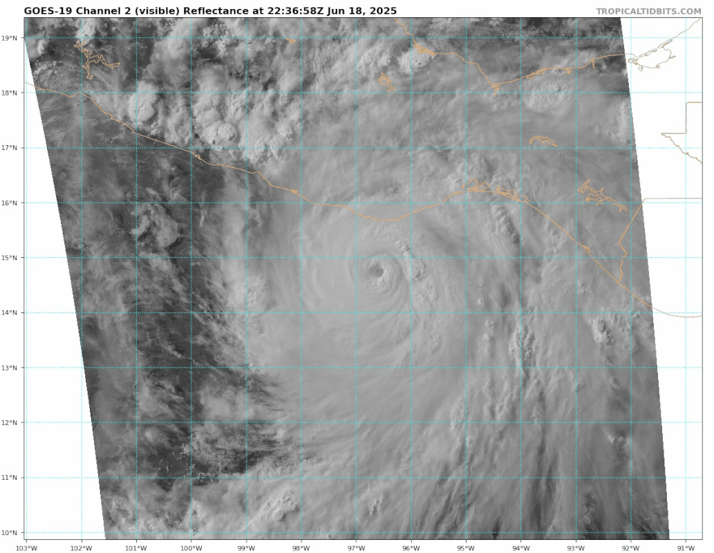
fix. An eye has been present in visible and infrared satellite
imagery since about 15Z this morning, and recent satellite imagery
shows the eye continuing to become more circular with warming eye
temperatures. The eye is nearly completely surrounded by a large
area of convective cloud tops colder than -70C. As a result,
satellite intensity estimates have been increasing quickly. The
18Z subjective Dvorak estimates from TAFB and SAB range from 90-102
kt. Recent objective intensity estimates from UW-CIMSS are in the
95-100 kt range. Based on a blend of the data, the initial
intensity is estimated to be 95 kt, and this might be a bit
conservative.
The initial motion estimate is northwestward, or 315/8 kt. This
general motion, along with perhaps a slight acceleration, is
expected through landfall, which is forecast to occur early Thursday
morning along the southern coast of Mexico. Erick has been moving
to the right of the previous official forecast, and as a result,
the new guidance shows landfall slightly to the east of the
previous track. The new NHC track forecast is shifted eastward,
close to the latest TVCE and HCCA consensus aids. Confidence in
the track forecast is high.
Erick has been rapidly strengthening for the past 12 hours, and
given the extremely favorable atmospheric and oceanic conditions
along Erick's forecast track, further intensification in the short
term appears very likely. The 12Z HAFS models and the 18Z SHIPS
guidance have Erick becoming a major hurricane soon. The various
SHIPS Rapid Intensification indices all show greater than a 70
percent chance of 20 kt strengthening in the next 12 h. The new
NHC forecast shows 110 kt at 12 h, which is at the high end of the
intensity guidance suite. There is a possibility that Erick could
strengthen more than forecast.
The next Air Force Reconnaissance aircraft is scheduled to be in
the hurricane in a few hours, around 2330 UTC today.
KEY MESSAGES:
1. Erick continues to rapidly intensify and is expected to be a
major hurricane when it reaches the coast of western Oaxaca or
eastern Guerrero within the hurricane warning area late tonight or
early Thursday. Devastating wind damage is possible where the core
of the storm moves onshore. Weather conditions are already
deteriorating, and preparations to protect life and property should
be rushed to completion before sunset.
2. Erick will produce heavy rainfall across portions of Central
America and Southwest Mexico through this week. Life-threatening
flooding and mudslides are likely, especially in areas of steep
terrain.
3. A dangerous, life-threatening storm surge is expected to produce
coastal flooding near and to the east of where the center crosses
the coast, in areas of onshore winds. The surge will be accompanied
by large and destructive waves.
FORECAST POSITIONS AND MAX WINDS
INIT 18/2100Z 14.5N 96.5W 95 KT 110 MPH
12H 19/0600Z 15.5N 97.4W 110 KT 125 MPH
24H 19/1800Z 17.0N 98.8W 55 KT 65 MPH...INLAND
36H 20/0600Z 18.5N 100.4W 20 KT 25 MPH...POST-TROP/REMNT LOW
48H 20/1800Z...DISSIPATED
$$
Forecaster Hagen
NWS National Hurricane Center Miami FL EP052025
300 PM CST Wed Jun 18 2025
An Air Force Reconnaissance aircraft completed its mission into
Erick this morning and found 93-kt flight-level winds at 700 mb
along with a dropsonde central pressure of 971 mb around 17Z. The
recon data showed strengthening in between the 1530Z fix and the 17Z
fix. An eye has been present in visible and infrared satellite
imagery since about 15Z this morning, and recent satellite imagery
shows the eye continuing to become more circular with warming eye
temperatures. The eye is nearly completely surrounded by a large
area of convective cloud tops colder than -70C. As a result,
satellite intensity estimates have been increasing quickly. The
18Z subjective Dvorak estimates from TAFB and SAB range from 90-102
kt. Recent objective intensity estimates from UW-CIMSS are in the
95-100 kt range. Based on a blend of the data, the initial
intensity is estimated to be 95 kt, and this might be a bit
conservative.
The initial motion estimate is northwestward, or 315/8 kt. This
general motion, along with perhaps a slight acceleration, is
expected through landfall, which is forecast to occur early Thursday
morning along the southern coast of Mexico. Erick has been moving
to the right of the previous official forecast, and as a result,
the new guidance shows landfall slightly to the east of the
previous track. The new NHC track forecast is shifted eastward,
close to the latest TVCE and HCCA consensus aids. Confidence in
the track forecast is high.
Erick has been rapidly strengthening for the past 12 hours, and
given the extremely favorable atmospheric and oceanic conditions
along Erick's forecast track, further intensification in the short
term appears very likely. The 12Z HAFS models and the 18Z SHIPS
guidance have Erick becoming a major hurricane soon. The various
SHIPS Rapid Intensification indices all show greater than a 70
percent chance of 20 kt strengthening in the next 12 h. The new
NHC forecast shows 110 kt at 12 h, which is at the high end of the
intensity guidance suite. There is a possibility that Erick could
strengthen more than forecast.
The next Air Force Reconnaissance aircraft is scheduled to be in
the hurricane in a few hours, around 2330 UTC today.
KEY MESSAGES:
1. Erick continues to rapidly intensify and is expected to be a
major hurricane when it reaches the coast of western Oaxaca or
eastern Guerrero within the hurricane warning area late tonight or
early Thursday. Devastating wind damage is possible where the core
of the storm moves onshore. Weather conditions are already
deteriorating, and preparations to protect life and property should
be rushed to completion before sunset.
2. Erick will produce heavy rainfall across portions of Central
America and Southwest Mexico through this week. Life-threatening
flooding and mudslides are likely, especially in areas of steep
terrain.
3. A dangerous, life-threatening storm surge is expected to produce
coastal flooding near and to the east of where the center crosses
the coast, in areas of onshore winds. The surge will be accompanied
by large and destructive waves.
FORECAST POSITIONS AND MAX WINDS
INIT 18/2100Z 14.5N 96.5W 95 KT 110 MPH
12H 19/0600Z 15.5N 97.4W 110 KT 125 MPH
24H 19/1800Z 17.0N 98.8W 55 KT 65 MPH...INLAND
36H 20/0600Z 18.5N 100.4W 20 KT 25 MPH...POST-TROP/REMNT LOW
48H 20/1800Z...DISSIPATED
$$
Forecaster Hagen
2 likes
Visit the Caribbean-Central America Weather Thread where you can find at first post web cams,radars
and observations from Caribbean basin members Click Here
and observations from Caribbean basin members Click Here
-
Hurricane2022

- Category 5

- Posts: 2096
- Joined: Tue Aug 23, 2022 11:38 pm
- Location: Araçatuba, Brazil
Re: EPAC: ERICK - Hurricane - Discussion
2 likes
Sorry for the bad English sometimes...!
For reliable and detailed information for any meteorological phenomenon, please consult the National Hurricane Center, Joint Typhoon Warning Center , or your local Meteo Center.
--------
ECCE OMNIA NOVA FACIAM (Ap 21,5).
For reliable and detailed information for any meteorological phenomenon, please consult the National Hurricane Center, Joint Typhoon Warning Center , or your local Meteo Center.
--------
ECCE OMNIA NOVA FACIAM (Ap 21,5).
-
cycloneye
- Admin
- Posts: 149816
- Age: 69
- Joined: Thu Oct 10, 2002 10:54 am
- Location: San Juan, Puerto Rico
Re: EPAC: ERICK - Hurricane - Discussion
0 likes
Visit the Caribbean-Central America Weather Thread where you can find at first post web cams,radars
and observations from Caribbean basin members Click Here
and observations from Caribbean basin members Click Here


Re: EPAC: ERICK - Hurricane - Discussion
Looks like the eye is warming and trying to clear.
0 likes
The above post and any post by Ntxw is NOT an official forecast and should not be used as such. It is just the opinion of the poster and may or may not be backed by sound meteorological data. It is NOT endorsed by any professional institution including Storm2k. For official information, please refer to NWS products.
Help support Storm2K!

-
Kingarabian

- S2K Supporter

- Posts: 16383
- Joined: Sat Aug 08, 2009 3:06 am
- Location: Honolulu, Hawaii
Re: EPAC: ERICK - Hurricane - Discussion
Instant T6.5 while constraints keep it at T5.5. Regardless this is a major hurricane.
0 likes
RIP Kobe Bryant

-
cycloneye
- Admin
- Posts: 149816
- Age: 69
- Joined: Thu Oct 10, 2002 10:54 am
- Location: San Juan, Puerto Rico
Re: EPAC: ERICK - Hurricane - Discussion
Eye is larger than earlier.

0 likes
Visit the Caribbean-Central America Weather Thread where you can find at first post web cams,radars
and observations from Caribbean basin members Click Here
and observations from Caribbean basin members Click Here

Re: EPAC: ERICK - Hurricane - Discussion
It really looks like there’s a moat starting to form on visible imagery. Start of an EWRC or another bit of dry air starting to sneak in? I’ve noticed a few brief bits of partial CDO degradation today that might’ve been from dry air.
0 likes
Irene '11 Sandy '12 Hermine '16 5/15/2018 Derecho Fay '20 Isaias '20 Elsa '21 Henri '21 Ida '21
I am only a meteorology enthusiast who knows a decent amount about tropical cyclones. Look to the professional mets, the NHC, or your local weather office for the best information.
I am only a meteorology enthusiast who knows a decent amount about tropical cyclones. Look to the professional mets, the NHC, or your local weather office for the best information.
-
Kingarabian
- S2K Supporter
- Posts: 16383
- Joined: Sat Aug 08, 2009 3:06 am
- Location: Honolulu, Hawaii
Re: EPAC: ERICK - Hurricane - Discussion
aspen wrote:It really looks like there’s a moat starting to form on visible imagery. Start of an EWRC or another bit of dry air starting to sneak in? I’ve noticed a few brief bits of partial CDO degradation today that might’ve been from dry air.
Looks like some eyewall melds going on.
0 likes
RIP Kobe Bryant

Re: EPAC: ERICK - Hurricane - Discussion
2 likes
TC naming lists: retirements and intensity
Most aggressive Advisory #1's in North Atlantic (cr. kevin for starting the list)
Most aggressive Advisory #1's in North Atlantic (cr. kevin for starting the list)
-
Hurricane2022
- Category 5
- Posts: 2096
- Joined: Tue Aug 23, 2022 11:38 pm
- Location: Araçatuba, Brazil
Re: EPAC: ERICK - Hurricane - Discussion
Teban54 wrote:[url]https://i.postimg.cc/tTtG4x7n/goes19-ir-meso2-1.gif [/url]
[url]https://i.postimg.cc/DwHTjht0/goes19-vis-meso2.gif [/url]
Hurricane Erick strangely looks better than before on VIS with this ongoing ERC IMO
Last edited by Hurricane2022 on Wed Jun 18, 2025 6:27 pm, edited 1 time in total.
0 likes
Sorry for the bad English sometimes...!
For reliable and detailed information for any meteorological phenomenon, please consult the National Hurricane Center, Joint Typhoon Warning Center , or your local Meteo Center.
--------
ECCE OMNIA NOVA FACIAM (Ap 21,5).
For reliable and detailed information for any meteorological phenomenon, please consult the National Hurricane Center, Joint Typhoon Warning Center , or your local Meteo Center.
--------
ECCE OMNIA NOVA FACIAM (Ap 21,5).
-
cycloneye
- Admin
- Posts: 149816
- Age: 69
- Joined: Thu Oct 10, 2002 10:54 am
- Location: San Juan, Puerto Rico
Re: EPAC: ERICK - Hurricane - Discussion
Next set reaches the eye.
Peak Flight-Level Winds: 84kt at 23:18z
Peak SFMR: 82kt at 23:19z
Minimum Extrap. Pressure: 962.1mb at 23:23z
Peak SFMR: 82kt at 23:19z
Minimum Extrap. Pressure: 962.1mb at 23:23z
2 likes
Visit the Caribbean-Central America Weather Thread where you can find at first post web cams,radars
and observations from Caribbean basin members Click Here
and observations from Caribbean basin members Click Here

Re: EPAC: ERICK - Hurricane - Discussion
Extrapolated pressure = 953.8 mb with 10 kt winds nearby -> 953 mb
Peak FL = 102 kt -> 92 kt at the surface
Peak SFMR = 99 kt
Based on this pass I'd put Erick at 953mb/95kt. The dropsonde also supports 952 - 953 mb.
Peak FL = 102 kt -> 92 kt at the surface
Peak SFMR = 99 kt
Based on this pass I'd put Erick at 953mb/95kt. The dropsonde also supports 952 - 953 mb.
1 likes
-
cycloneye
- Admin
- Posts: 149816
- Age: 69
- Joined: Thu Oct 10, 2002 10:54 am
- Location: San Juan, Puerto Rico
Re: EPAC: ERICK - Hurricane - Discussion
Peak Flight-Level Winds: 97kt at 23:31z
Peak SFMR: 84kt at 23:31z
Minimum Extrap. Pressure: 953.8mb at 23:24z
Peak SFMR: 84kt at 23:31z
Minimum Extrap. Pressure: 953.8mb at 23:24z
0 likes
Visit the Caribbean-Central America Weather Thread where you can find at first post web cams,radars
and observations from Caribbean basin members Click Here
and observations from Caribbean basin members Click Here
-
cycloneye
- Admin
- Posts: 149816
- Age: 69
- Joined: Thu Oct 10, 2002 10:54 am
- Location: San Juan, Puerto Rico
Re: EPAC: ERICK - Hurricane - Discussion
Major hurricane
BULLETIN
Hurricane Erick Intermediate Advisory Number 9A
NWS National Hurricane Center Miami FL EP052025
600 PM CST Wed Jun 18 2025
...HURRICANE HUNTER AIRCRAFT REPORTS ERICK IS A MAJOR HURRICANE...
...EXPECTED TO BRING POTENTIALLY DESTRUCTIVE WINDS AND
LIFE-THREATENING FLASH FLOODS TO PORTIONS OF SOUTHERN MEXICO LATE
TONIGHT AND THURSDAY...
SUMMARY OF 600 PM CST...0000 UTC...INFORMATION
----------------------------------------------
LOCATION...14.9N 96.7W
ABOUT 55 MI...90 KM SSW OF PUERTO ANGEL MEXICO
ABOUT 160 MI...260 KM SE OF PUNTA MALDONADO MEXICO
MAXIMUM SUSTAINED WINDS...120 MPH...195 KM/H
PRESENT MOVEMENT...NW OR 315 DEGREES AT 9 MPH...15 KM/H
MINIMUM CENTRAL PRESSURE...953 MB...28.14 INCHES
3 likes
Visit the Caribbean-Central America Weather Thread where you can find at first post web cams,radars
and observations from Caribbean basin members Click Here
and observations from Caribbean basin members Click Here
Re: EPAC: ERICK - Hurricane - Discussion
I guess they're strongly leaning into the undersampling factor with their current wind estimate, which sounds reasonable considering the uneven wind profile of a hurricane during an EWRC. I would've expected them to go with 100 kt, but 105 sounds realistic as well. Either way, the "Additional strengthening is expected until the center makes landfall" sentence is quite concerning.
Last edited by kevin on Wed Jun 18, 2025 6:54 pm, edited 1 time in total.
2 likes
-
galaxy401

- Category 5
- Posts: 2446
- Age: 30
- Joined: Sat Aug 25, 2012 9:04 pm
- Location: Casa Grande, Arizona
Re: EPAC: ERICK - Hurricane - Discussion Update=Major hurricane=120 mph
This region is probably one of the most favorable areas in the Western Hemisphere. Not many storms can take advantage of it due to moving westward but there seems to be a trend the last few years of storms popping up and exploding before landfall.
Likely will be a Cat 4 before landfall and he's casually taking his time before land too.
Likely will be a Cat 4 before landfall and he's casually taking his time before land too.
2 likes
Got my eyes on moving right into Hurricane Alley: Florida.

Re: EPAC: ERICK - Hurricane - Discussion Update=Major hurricane=120 mph
Let's see what the next pass through the eyewall shows for how well that ERC has gone.
0 likes
-
Kingarabian
- S2K Supporter
- Posts: 16383
- Joined: Sat Aug 08, 2009 3:06 am
- Location: Honolulu, Hawaii
Re: EPAC: ERICK - Hurricane - Discussion Update=Major hurricane=120 mph
galaxy401 wrote:This region is probably one of the most favorable areas in the Western Hemisphere. Not many storms can take advantage of it due to moving westward but there seems to be a trend the last few years of storms popping up and exploding before landfall.
Likely will be a Cat 4 before landfall and he's casually taking his time before land too.
100% agree.
0 likes
RIP Kobe Bryant
Who is online
Users browsing this forum: No registered users and 35 guests