This will be the biggest threat for Mexico, the massive flooding.
https://x.com/PhilFerro7/status/1935130008739066318
EPAC: ERICK - Post-Tropical - Discussion
Moderator: S2k Moderators
-
cycloneye

- Admin

- Posts: 149817
- Age: 69
- Joined: Thu Oct 10, 2002 10:54 am
- Location: San Juan, Puerto Rico
Re: EPAC: ERICK - Tropical Storm - Discussion
0 likes
Visit the Caribbean-Central America Weather Thread where you can find at first post web cams,radars
and observations from Caribbean basin members Click Here
and observations from Caribbean basin members Click Here
-
Kingarabian

- S2K Supporter

- Posts: 16383
- Joined: Sat Aug 08, 2009 3:06 am
- Location: Honolulu, Hawaii
Re: EPAC: ERICK - Tropical Storm - Discussion
Well convection is warming. New hot tower going off near the center. We'll see if this follows the first 4 systems. Looking promising before falling off. Regardless it'll be a dangerous system because of the rain threat.
0 likes
RIP Kobe Bryant
-
cycloneye
- Admin
- Posts: 149817
- Age: 69
- Joined: Thu Oct 10, 2002 10:54 am
- Location: San Juan, Puerto Rico
Re: EPAC: ERICK - Tropical Storm - Discussion
Look what we have here 4.0.
A. 05E (ERICK)
B. 18/0000Z
C. 12.8N
D. 94.8W
E. THREE/GOES-E
F. T4.0/4.0
G. IR/EIR/VIS/GMI
H. REMARKS...12/10 BANDING RESULTS IN A DT OF 4.0. THE MET AND THE PT
ARE BOTH 3.5. THE FT IS BASED ON THE DT.
I. ADDL POSITIONS
17/1829Z 12.6N 94.5W GMI
...LINER
B. 18/0000Z
C. 12.8N
D. 94.8W
E. THREE/GOES-E
F. T4.0/4.0
G. IR/EIR/VIS/GMI
H. REMARKS...12/10 BANDING RESULTS IN A DT OF 4.0. THE MET AND THE PT
ARE BOTH 3.5. THE FT IS BASED ON THE DT.
I. ADDL POSITIONS
17/1829Z 12.6N 94.5W GMI
...LINER
1 likes
Visit the Caribbean-Central America Weather Thread where you can find at first post web cams,radars
and observations from Caribbean basin members Click Here
and observations from Caribbean basin members Click Here
-
Kingarabian
- S2K Supporter
- Posts: 16383
- Joined: Sat Aug 08, 2009 3:06 am
- Location: Honolulu, Hawaii
Re: EPAC: ERICK - Tropical Storm - Discussion
Fresh SSMIS pass shows a great low level structure. However it is less defined at the mid levels.


1 likes
RIP Kobe Bryant
-
cycloneye
- Admin
- Posts: 149817
- Age: 69
- Joined: Thu Oct 10, 2002 10:54 am
- Location: San Juan, Puerto Rico
Re: EPAC: ERICK - Tropical Storm - Discussion
1 likes
Visit the Caribbean-Central America Weather Thread where you can find at first post web cams,radars
and observations from Caribbean basin members Click Here
and observations from Caribbean basin members Click Here
-
cycloneye
- Admin
- Posts: 149817
- Age: 69
- Joined: Thu Oct 10, 2002 10:54 am
- Location: San Juan, Puerto Rico
Re: EPAC: ERICK - Tropical Storm - Discussion
In general, the 00z runs are less bullish.

0 likes
Visit the Caribbean-Central America Weather Thread where you can find at first post web cams,radars
and observations from Caribbean basin members Click Here
and observations from Caribbean basin members Click Here
-
DorkyMcDorkface

- Category 5

- Posts: 1063
- Age: 28
- Joined: Mon Sep 30, 2019 1:32 pm
- Location: Mid-Atlantic
Re: EPAC: ERICK - Tropical Storm - Discussion
1 likes
Please note the thoughts expressed by this account are solely those of the user and are from a hobbyist perspective. For more comprehensive analysis, consult an actual professional meteorologist or meteorological agency.
Floyd 1999 | Isabel 2003 | Hanna 2008 | Irene 2011 | Sandy 2012 | Isaias 2020
-
cycloneye
- Admin
- Posts: 149817
- Age: 69
- Joined: Thu Oct 10, 2002 10:54 am
- Location: San Juan, Puerto Rico
Re: EPAC: ERICK - Tropical Storm - Discussion
BULLETIN
Tropical Storm Erick Advisory Number 6
NWS National Hurricane Center Miami FL EP052025
900 PM CST Tue Jun 17 2025
...ERICK FORECAST TO BRING HURRICANE CONDITIONS AND LIFE-THREATENING
FLASH FLOODS TO PORTIONS OF SOUTHERN MEXICO WEDNESDAY NIGHT AND
THURSDAY...
SUMMARY OF 900 PM CST...0300 UTC...INFORMATION
----------------------------------------------
LOCATION...13.1N 94.9W
ABOUT 210 MI...335 KM SSE OF PUERTO ANGEL MEXICO
ABOUT 330 MI...535 KM SE OF PUNTA MALDONADO MEXICO
MAXIMUM SUSTAINED WINDS...60 MPH...95 KM/H
PRESENT MOVEMENT...NW OR 310 DEGREES AT 7 MPH...11 KM/H
MINIMUM CENTRAL PRESSURE...998 MB...29.47 INCHES
WATCHES AND WARNINGS
--------------------
CHANGES WITH THIS ADVISORY:
The government of Mexico has issued a Hurricane Warning from
Puerto Angel to Acapulco. A Hurricane Watch has been issued from
west of Acapulco to Tecpan de Galeana.
Tropical Storm Erick Discussion Number 6
NWS National Hurricane Center Miami FL EP052025
900 PM CST Tue Jun 17 2025
Satellite imagery shows that Erick is becoming increasingly
well-organized. Deep convection has expanded and cooled, with
enhanced infrared imagery indicating cloud tops as cold as -85 C
near the center. A recent SSMIS microwave pass revealed an improved
inner-core structure, including a developing curved band. The latest
Dvorak estimates from TAFB and SAB were T3.0 and T4.0, respectively,
and objective ADT values are approaching T3.5. In addition,
just-received synthetic aperture radar data indicate winds near
50 kt. The initial intensity is increased to 50 kt for this
advisory to represent a blend of these estimates.
Erick is moving northwestward at about 310/6 kt. This slowing in
forward speed is consistent with a weakening of the mid-level ridge
to the north, caused by a mid- to upper-level trough progressing
eastward across the central United States. This general motion is
expected to continue through landfall, with only a gradual increase
in forward speed. The track guidance remains in good agreement and
continues to show the center of Erick approaching the coast of
southern Mexico within the next 24 to 36 hours. Although confidence
in the overall track is relatively high, small deviations could lead
to significant changes in where and when the strongest winds and
coastal impacts occur. The official forecast lies near the consensus
of the HCCA and TVCE aids and is very close to the previous NHC
track.
The environment ahead of Erick remains highly conducive for
additional strengthening, with sea surface temperatures near 29 C,
low vertical wind shear, and abundant mid-level moisture. Several
dynamic regional models bring Erick to major hurricane strength
before landfall, and the Rapid Intensification (RI) guidance
continues to indicate a significant chance for rapid strengthening
in the next 24 to 36 hours. The NHC forecast remains near the upper
end of the guidance envelope but could still be somewhat
conservative, especially if the current trend of improved structure
continues overnight.
KEY MESSAGES:
1. Erick is expected to rapidly intensify before reaching the coast
of southern Mexico on Thursday, and a hurricane warning is in effect
for portions of the coast of Oaxaca and Guerrero coast.
2. Erick will produce heavy rainfall across portions of Central
America and Southwest Mexico through this week. Life-threatening
flooding and mudslides are possible, especially in areas of steep
terrain.
3. A dangerous storm surge is expected to produce coastal flooding
near and to the east of where the center crosses the coast, in
areas of onshore winds.
FORECAST POSITIONS AND MAX WINDS
INIT 18/0300Z 13.1N 94.9W 50 KT 60 MPH
12H 18/1200Z 13.7N 95.7W 65 KT 75 MPH
24H 19/0000Z 14.7N 96.8W 85 KT 100 MPH
36H 19/1200Z 16.0N 98.2W 95 KT 110 MPH
48H 20/0000Z 17.4N 100.0W 70 KT 80 MPH...INLAND
60H 20/1200Z 18.8N 101.9W 30 KT 35 MPH...INLAND
72H 21/0000Z...DISSIPATED
$$
Forecaster Gibbs/Bucci
0 likes
Visit the Caribbean-Central America Weather Thread where you can find at first post web cams,radars
and observations from Caribbean basin members Click Here
and observations from Caribbean basin members Click Here
-
Sciencerocks
- Category 5
- Posts: 10194
- Age: 40
- Joined: Thu Jul 06, 2017 1:51 am

-
cycloneye
- Admin
- Posts: 149817
- Age: 69
- Joined: Thu Oct 10, 2002 10:54 am
- Location: San Juan, Puerto Rico
Re: EPAC: ERICK - Tropical Storm - Discussion
DMAX will come soon and will do the RI phase.
0 likes
Visit the Caribbean-Central America Weather Thread where you can find at first post web cams,radars
and observations from Caribbean basin members Click Here
and observations from Caribbean basin members Click Here
-
cheezyWXguy

- Category 5
- Posts: 6284
- Joined: Mon Feb 13, 2006 12:29 am
- Location: Dallas, TX
Re: EPAC: ERICK - Tropical Storm - Discussion
Towers around the whole center now. Should see appreciable strengthening in the coming hours
1 likes
-
Yellow Evan

- Professional-Met

- Posts: 16257
- Age: 27
- Joined: Fri Jul 15, 2011 12:48 pm
- Location: Henderson, Nevada/Honolulu, HI
- Contact:
Re: EPAC: ERICK - Tropical Storm - Discussion
CB has quickly wrapped around what appears to be an eyewall. Erick is likely to be deepening quicker now.
1 likes
-
Astromanía
- Category 3

- Posts: 802
- Age: 27
- Joined: Sat Aug 25, 2018 10:34 pm
- Location: Monterrey, N.L, México
-
weeniepatrol

- Category 5
- Posts: 1345
- Joined: Sat Aug 22, 2020 5:30 pm
- Location: WA State
Re: EPAC: ERICK - Tropical Storm - Discussion
Btw, the number of June major hurricane landfalls for Mexico is zero.

0 likes
-
Kingarabian
- S2K Supporter
- Posts: 16383
- Joined: Sat Aug 08, 2009 3:06 am
- Location: Honolulu, Hawaii
-
Yellow Evan
- Professional-Met
- Posts: 16257
- Age: 27
- Joined: Fri Jul 15, 2011 12:48 pm
- Location: Henderson, Nevada/Honolulu, HI
- Contact:
Re: EPAC: ERICK - Tropical Storm - Discussion
Not sure why this is still at 50 knots officially to be blunt with the low level structure and ADT estimates as well as SAB estimates supporting near or at hurricane strength.
1 likes
-
Yellow Evan
- Professional-Met
- Posts: 16257
- Age: 27
- Joined: Fri Jul 15, 2011 12:48 pm
- Location: Henderson, Nevada/Honolulu, HI
- Contact:
Re: EPAC: ERICK - Tropical Storm - Discussion
18/0600 UTC 13.0N 95.0W T4.5/4.5 ERICK -- East Pacific
0 likes

Re: EPAC: ERICK - Tropical Storm - Discussion
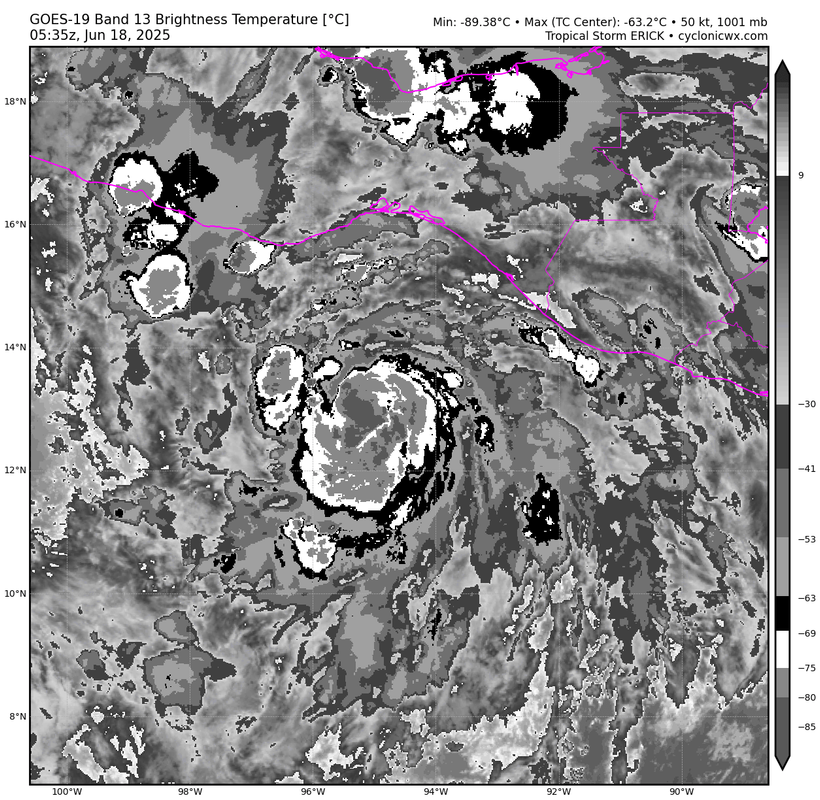
Quite extreme CDO cooling over the last 3 hours from -55C to -70.5C (so a rate of about -5C/hr). Combined with the IR imagery a very strong indicator that RI has started. The dramatic cooling might even indicate ERI.
0 likes
-
Yellow Evan
- Professional-Met
- Posts: 16257
- Age: 27
- Joined: Fri Jul 15, 2011 12:48 pm
- Location: Henderson, Nevada/Honolulu, HI
- Contact:

-
Yellow Evan
- Professional-Met
- Posts: 16257
- Age: 27
- Joined: Fri Jul 15, 2011 12:48 pm
- Location: Henderson, Nevada/Honolulu, HI
- Contact:
Re: EPAC: ERICK - Tropical Storm - Discussion
EP, 05, 2025061806, , BEST, 0, 131N, 951W, 55, 996, TS, 34, NEQ, 60, 40, 30, 30, 1008, 180, 20, 0, 0, E, 0, , 0, 0, ERICK, M, 0, , 0, 0, 0, 0, genesis-num, 006,
0 likes
Who is online
Users browsing this forum: No registered users and 27 guests