
EPAC: DALILA - Post-Tropical - Discussion
Moderator: S2k Moderators
-
cycloneye

- Admin

- Posts: 149825
- Age: 69
- Joined: Thu Oct 10, 2002 10:54 am
- Location: San Juan, Puerto Rico
Re: EPAC: DALILA - Tropical Storm - Discussion
1 likes
Visit the Caribbean-Central America Weather Thread where you can find at first post web cams,radars
and observations from Caribbean basin members Click Here
and observations from Caribbean basin members Click Here
-
Kingarabian

- S2K Supporter

- Posts: 16383
- Joined: Sat Aug 08, 2009 3:06 am
- Location: Honolulu, Hawaii
Re: EPAC: DALILA - Tropical Storm - Discussion
Constraints holding back the Dvorak numbers. But should be a T4.0 soon.
0 likes
RIP Kobe Bryant
-
cycloneye
- Admin
- Posts: 149825
- Age: 69
- Joined: Thu Oct 10, 2002 10:54 am
- Location: San Juan, Puerto Rico
Re: EPAC: DALILA - Tropical Storm - Discussion
BULLETIN
Tropical Storm Dalila Intermediate Advisory Number 7A
NWS National Hurricane Center Miami FL EP042025
600 AM CST Sat Jun 14 2025
...OUTER BANDS OF DALILA IMPACTING SOUTHWESTERN MEXICO...
SUMMARY OF 600 AM CST...1200 UTC...INFORMATION
----------------------------------------------
LOCATION...16.1N 104.3W
ABOUT 215 MI...345 KM WSW OF ZIHUATANEJO MEXICO
MAXIMUM SUSTAINED WINDS...50 MPH...85 KM/H
PRESENT MOVEMENT...NW OR 305 DEGREES AT 12 MPH...19 KM/H
MINIMUM CENTRAL PRESSURE...999 MB...29.50 INCHES
0 likes
Visit the Caribbean-Central America Weather Thread where you can find at first post web cams,radars
and observations from Caribbean basin members Click Here
and observations from Caribbean basin members Click Here
-
cycloneye
- Admin
- Posts: 149825
- Age: 69
- Joined: Thu Oct 10, 2002 10:54 am
- Location: San Juan, Puerto Rico
Re: EPAC: DALILA - Tropical Storm - Discussion
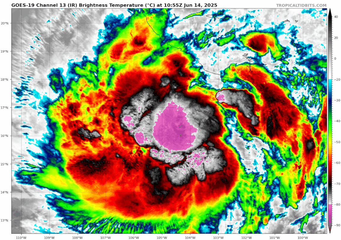
EP, 04, 2025061412, , BEST, 0, 162N, 1043W, 50, 996, TS
A. 04E (DALILA)
B. 14/1200Z
C. 16.2N
D. 104.1W
E. THREE/GOES-E
F. T3.5/3.5
G. IR/EIR/SWIR
H. REMARKS...10/10 BANDING YIELDS A DT=3.5. MET=3.0. PT=3.5. THE FT IS
BASED ON THE DT
B. 14/1200Z
C. 16.2N
D. 104.1W
E. THREE/GOES-E
F. T3.5/3.5
G. IR/EIR/SWIR
H. REMARKS...10/10 BANDING YIELDS A DT=3.5. MET=3.0. PT=3.5. THE FT IS
BASED ON THE DT
0 likes
Visit the Caribbean-Central America Weather Thread where you can find at first post web cams,radars
and observations from Caribbean basin members Click Here
and observations from Caribbean basin members Click Here
-
cycloneye
- Admin
- Posts: 149825
- Age: 69
- Joined: Thu Oct 10, 2002 10:54 am
- Location: San Juan, Puerto Rico
Re: EPAC: DALILA - Tropical Storm - Discussion
BULLETIN
Tropical Storm Dalila Advisory Number 8
NWS National Hurricane Center Miami FL EP042025
900 AM CST Sat Jun 14 2025
...DALILA'S OUTER RAINBANDS AFFECTING SOUTHWESTERN MEXICO...
SUMMARY OF 900 AM CST...1500 UTC...INFORMATION
----------------------------------------------
LOCATION...16.5N 104.8W
ABOUT 175 MI...285 KM S OF MANZANILLO MEXICO
MAXIMUM SUSTAINED WINDS...60 MPH...95 KM/H
PRESENT MOVEMENT...NW OR 305 DEGREES AT 12 MPH...19 KM/H
MINIMUM CENTRAL PRESSURE...996 MB...29.42 INCHES
Tropical Storm Dalila Discussion Number 8
NWS National Hurricane Center Miami FL EP042025
900 AM CST Sat Jun 14 2025
Dalila continues to show signs of strengthening, with deep
convection bursting over the low-level center, and curved banding
features near the coast of southwestern Mexico. There is a fairly
large range of satellite intensity estimates this morning from 45 to
65 kt. Given the improving satellite presentation, the initial
intensity is raised to 50 kt for this advisory. A scatterometer pass
is scheduled over the system around 16Z, which may give a better
estimate of surface winds.
The storm is currently moving northwestward at an estimated 305/10
kt. A mid-level ridge is building westward over northern Mexico,
which should cause Dalila to gradually turn west-northwestward
later today. As the system begins to weaken into a shallower vortex
on Sunday, Dalila will turn more westward within the low-level wind
flow. The latest NHC forecast is near the previous one, and lies
near the latest simple and corrected consensus aids.
Dalila may be nearing peak intensity, with only about 6 to 12 h left
within a favorable environment. Thus, the NHC forecast shows slight
strengthening today, with a peak intensity of 55 kt. Along the
forecast track, Dalila will move over much cooler SSTs tonight and
begin to enter a drier, more stable airmass. This will lead to
steady weakening, and eventually the system will struggle to produce
convection. The NHC intensity forecast is near the previous one,
however now shows the system becoming a remnant low in 48 h,
although this could occur sooner. By day 4, models depict the
remnant low dissipating into an open trough.
KEY MESSAGES:
1. The outer bands of Tropical Storm Dalila will bring locally heavy
rainfall to the Mexican states of Michoacán and Guerrero through
Sunday morning. Scattered areas of flooding and mudslides are
expected, especially in areas of steep terrain near the coast.
2. Dalila is expected to produce tropical-storm-force winds across
portions of the warning area today.
FORECAST POSITIONS AND MAX WINDS
INIT 14/1500Z 16.5N 104.8W 50 KT 60 MPH
12H 15/0000Z 17.3N 106.2W 55 KT 65 MPH
24H 15/1200Z 17.9N 108.2W 45 KT 50 MPH
36H 16/0000Z 18.1N 110.2W 35 KT 40 MPH
48H 16/1200Z 18.1N 112.0W 30 KT 35 MPH...POST-TROP/REMNT LOW
60H 17/0000Z 18.2N 113.9W 20 KT 25 MPH...POST-TROP/REMNT LOW
72H 17/1200Z 18.2N 115.5W 20 KT 25 MPH...POST-TROP/REMNT LOW
96H 18/1200Z...DISSIPATED
$$
Forecaster Kelly
0 likes
Visit the Caribbean-Central America Weather Thread where you can find at first post web cams,radars
and observations from Caribbean basin members Click Here
and observations from Caribbean basin members Click Here
-
Kingarabian
- S2K Supporter
- Posts: 16383
- Joined: Sat Aug 08, 2009 3:06 am
- Location: Honolulu, Hawaii
Re: EPAC: DALILA - Tropical Storm - Discussion
That NHC forecast looking like it will bust too weak.
MW imagery still lackluster in terms of core development. But IR/Dvorak analysis shows that this has the highest upside out of the 4 named systems so far.
MW imagery still lackluster in terms of core development. But IR/Dvorak analysis shows that this has the highest upside out of the 4 named systems so far.
0 likes
RIP Kobe Bryant

Re: EPAC: DALILA - Tropical Storm - Discussion
0 likes
TC naming lists: retirements and intensity
Most aggressive Advisory #1's in North Atlantic (cr. kevin for starting the list)
Most aggressive Advisory #1's in North Atlantic (cr. kevin for starting the list)
-
cycloneye
- Admin
- Posts: 149825
- Age: 69
- Joined: Thu Oct 10, 2002 10:54 am
- Location: San Juan, Puerto Rico
Re: EPAC: DALILA - Tropical Storm - Discussion
A faint eye feature?

0 likes
Visit the Caribbean-Central America Weather Thread where you can find at first post web cams,radars
and observations from Caribbean basin members Click Here
and observations from Caribbean basin members Click Here
-
Kingarabian
- S2K Supporter
- Posts: 16383
- Joined: Sat Aug 08, 2009 3:06 am
- Location: Honolulu, Hawaii
Re: EPAC: DALILA - Tropical Storm - Discussion
Core is forming on that visible image. This afternoons microwave images will show a lot. But so far it seems to be on its way to hurricane status.
0 likes
RIP Kobe Bryant
-
cycloneye
- Admin
- Posts: 149825
- Age: 69
- Joined: Thu Oct 10, 2002 10:54 am
- Location: San Juan, Puerto Rico
Re: EPAC: DALILA - Tropical Storm - Discussion
BULLETIN
Tropical Storm Dalila Intermediate Advisory Number 8A
NWS National Hurricane Center Miami FL EP042025
1200 PM CST Sat Jun 14 2025
...DALILA STRENGTHENS...
SUMMARY OF 1200 PM CST...1800 UTC...INFORMATION
-----------------------------------------------
LOCATION...16.6N 105.1W
ABOUT 170 MI...280 KM SSW OF MANZANILLO MEXICO
MAXIMUM SUSTAINED WINDS...65 MPH...100 KM/H
PRESENT MOVEMENT...NW OR 305 DEGREES AT 10 MPH...16 KM/H
MINIMUM CENTRAL PRESSURE...993 MB...29.32 INCHES
1 likes
Visit the Caribbean-Central America Weather Thread where you can find at first post web cams,radars
and observations from Caribbean basin members Click Here
and observations from Caribbean basin members Click Here
-
Yellow Evan

- Professional-Met

- Posts: 16257
- Age: 27
- Joined: Fri Jul 15, 2011 12:48 pm
- Location: Henderson, Nevada/Honolulu, HI
- Contact:
Re: EPAC: DALILA - Tropical Storm - Discussion
Clear 55 knots support from ASCAT. Most of the convection remains stuck upshear so not suited for even partial core development.
0 likes
-
cycloneye
- Admin
- Posts: 149825
- Age: 69
- Joined: Thu Oct 10, 2002 10:54 am
- Location: San Juan, Puerto Rico
Re: EPAC: DALILA - Tropical Storm - Discussion
There is the 55kt.
EP, 04, 2025061418, , BEST, 0, 166N, 1049W, 55, 993, TS
0 likes
Visit the Caribbean-Central America Weather Thread where you can find at first post web cams,radars
and observations from Caribbean basin members Click Here
and observations from Caribbean basin members Click Here
-
Sciencerocks
- Category 5

- Posts: 10194
- Age: 40
- Joined: Thu Jul 06, 2017 1:51 am

-
cycloneye
- Admin
- Posts: 149825
- Age: 69
- Joined: Thu Oct 10, 2002 10:54 am
- Location: San Juan, Puerto Rico
Re: EPAC: DALILA - Tropical Storm - Discussion
Reached peak intensity.
Tropical Storm Dalila Discussion Number 9
NWS National Hurricane Center Miami FL EP042025
300 PM CST Sat Jun 14 2025
Deep convection continues to burst over the center of Dalila, with
cold cloud tops near -80 C and a well-defined convective band shown
in satellite imagery. A recent scatterometer pass showed peak winds
near 55 kt, which prompted an increase in the estimated intensity to
55 kt during the intermediate advisory. Since then, the convective
structure has remained steady, and with both objective and
subjective satellite intensity estimates continuing to support this
intensity, thus, the initial intensity is held at 55 kt for this
advisory.
The initial motion is estimated at 300/9 kt. The storm is expected
to continue moving toward the west-northwest into tonight, then
begin turning toward the west by Sunday as the mid- to upper-level
ridge continues to strengthen to the north. The forecast guidance
remains in good agreement with this scenario, and the new forecast
track is close to the various consensus models and is similar to the
previous NHC forecast.
Dalila has likely reached its peak intensity and the storm may
maintain its current strength for a few more hours. By Sunday, the
storm will begin moving over cooler waters and into a drier, more
stable environment, which will initiate a weakening trend. The
system is forecast to become a remnant low in 48 hours, then
dissipate into an open trough in 72 hours. The NHC intensity
forecast closely follows a blend of the statistical-dynamical
guidance and is very similar to the previous forecast.
KEY MESSAGES:
1. The outer bands of Tropical Storm Dalila will bring locally heavy
rainfall to the Mexican states of Michoacán and Guerrero through
Sunday morning. Scattered areas of flooding and mudslides are
expected, especially in areas of steep terrain near the coast.
2. Dalila is expected to produce tropical-storm-force winds across
portions of the warning area today.
FORECAST POSITIONS AND MAX WINDS
INIT 14/2100Z 16.8N 105.5W 55 KT 65 MPH
12H 15/0600Z 17.4N 106.7W 50 KT 60 MPH
24H 15/1800Z 17.8N 108.7W 45 KT 50 MPH
36H 16/0600Z 17.9N 110.8W 35 KT 40 MPH...POST-TROPICAL
48H 16/1800Z 17.9N 112.6W 25 KT 30 MPH...POST-TROP/REMNT LOW
60H 17/0600Z 17.9N 114.1W 20 KT 25 MPH...POST-TROP/REMNT LOW
72H 17/1800Z...DISSIPATED
$$
Forecaster Gibbs/Kelly
0 likes
Visit the Caribbean-Central America Weather Thread where you can find at first post web cams,radars
and observations from Caribbean basin members Click Here
and observations from Caribbean basin members Click Here
-
Kingarabian
- S2K Supporter
- Posts: 16383
- Joined: Sat Aug 08, 2009 3:06 am
- Location: Honolulu, Hawaii
Re: EPAC: DALILA - Tropical Storm - Discussion
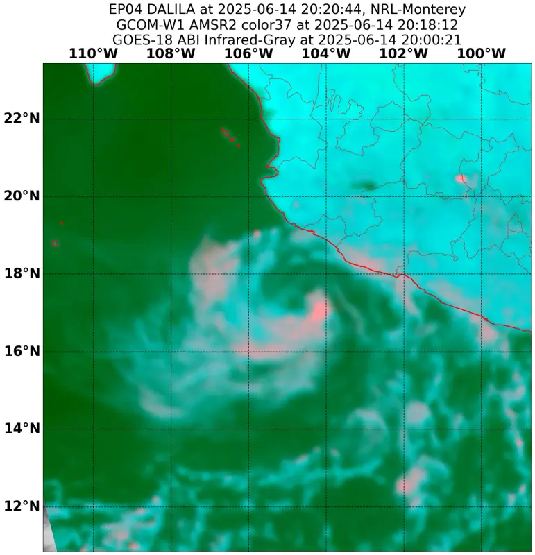
Latest AMSR2 pass shows a cyan ring and a core developing.
2 likes
RIP Kobe Bryant
-
cycloneye
- Admin
- Posts: 149825
- Age: 69
- Joined: Thu Oct 10, 2002 10:54 am
- Location: San Juan, Puerto Rico
Re: EPAC: DALILA - Tropical Storm - Discussion
BULLETIN
Tropical Storm Dalila Intermediate Advisory Number 9A
NWS National Hurricane Center Miami FL EP042025
600 PM CST Sat Jun 14 2025
...DALILA CONTINUES TO BRING STRONG WINDS AND HEAVY RAIN TO
PORTIONS OF SOUTHWEST MEXICO...
SUMMARY OF 600 PM CST...0000 UTC...INFORMATION
----------------------------------------------
LOCATION...17.2N 105.2W
ABOUT 135 MI...220 KM SSW OF MANZANILLO MEXICO
MAXIMUM SUSTAINED WINDS...65 MPH...100 KM/H
PRESENT MOVEMENT...WNW OR 300 DEGREES AT 10 MPH...17 KM/H
MINIMUM CENTRAL PRESSURE...993 MB...29.33 INCHES
0 likes
Visit the Caribbean-Central America Weather Thread where you can find at first post web cams,radars
and observations from Caribbean basin members Click Here
and observations from Caribbean basin members Click Here
-
Kingarabian
- S2K Supporter
- Posts: 16383
- Joined: Sat Aug 08, 2009 3:06 am
- Location: Honolulu, Hawaii
Re: EPAC: DALILA - Tropical Storm - Discussion
Eyewall trying to wrap around on IR. 3/4 there.
0 likes
RIP Kobe Bryant
-
cycloneye
- Admin
- Posts: 149825
- Age: 69
- Joined: Thu Oct 10, 2002 10:54 am
- Location: San Juan, Puerto Rico
Re: EPAC: DALILA - Tropical Storm - Discussion
Tropical Storm Dalila Discussion Number 9
NWS National Hurricane Center Miami FL EP042025
300 PM CST Sat Jun 14 2025
Deep convection continues to burst over the center of Dalila, with
cold cloud tops near -80 C and a well-defined convective band shown
in satellite imagery. A recent scatterometer pass showed peak winds
near 55 kt, which prompted an increase in the estimated intensity to
55 kt during the intermediate advisory. Since then, the convective
structure has remained steady, and with both objective and
subjective satellite intensity estimates continuing to support this
intensity, thus, the initial intensity is held at 55 kt for this
advisory.
The initial motion is estimated at 300/9 kt. The storm is expected
to continue moving toward the west-northwest into tonight, then
begin turning toward the west by Sunday as the mid- to upper-level
ridge continues to strengthen to the north. The forecast guidance
remains in good agreement with this scenario, and the new forecast
track is close to the various consensus models and is similar to the
previous NHC forecast.
Dalila has likely reached its peak intensity and the storm may
maintain its current strength for a few more hours. By Sunday, the
storm will begin moving over cooler waters and into a drier, more
stable environment, which will initiate a weakening trend. The
system is forecast to become a remnant low in 48 hours, then
dissipate into an open trough in 72 hours. The NHC intensity
forecast closely follows a blend of the statistical-dynamical
guidance and is very similar to the previous forecast.
KEY MESSAGES:
1. The outer bands of Tropical Storm Dalila will bring locally heavy
rainfall to the Mexican states of Michoacán and Guerrero through
Sunday morning. Scattered areas of flooding and mudslides are
expected, especially in areas of steep terrain near the coast.
2. Dalila is expected to produce tropical-storm-force winds across
portions of the warning area today.
FORECAST POSITIONS AND MAX WINDS
INIT 14/2100Z 16.8N 105.5W 55 KT 65 MPH
12H 15/0600Z 17.4N 106.7W 50 KT 60 MPH
24H 15/1800Z 17.8N 108.7W 45 KT 50 MPH
36H 16/0600Z 17.9N 110.8W 35 KT 40 MPH...POST-TROPICAL
48H 16/1800Z 17.9N 112.6W 25 KT 30 MPH...POST-TROP/REMNT LOW
60H 17/0600Z 17.9N 114.1W 20 KT 25 MPH...POST-TROP/REMNT LOW
72H 17/1800Z...DISSIPATED
$$
Forecaster Gibbs/Kelly
NWS National Hurricane Center Miami FL EP042025
300 PM CST Sat Jun 14 2025
Deep convection continues to burst over the center of Dalila, with
cold cloud tops near -80 C and a well-defined convective band shown
in satellite imagery. A recent scatterometer pass showed peak winds
near 55 kt, which prompted an increase in the estimated intensity to
55 kt during the intermediate advisory. Since then, the convective
structure has remained steady, and with both objective and
subjective satellite intensity estimates continuing to support this
intensity, thus, the initial intensity is held at 55 kt for this
advisory.
The initial motion is estimated at 300/9 kt. The storm is expected
to continue moving toward the west-northwest into tonight, then
begin turning toward the west by Sunday as the mid- to upper-level
ridge continues to strengthen to the north. The forecast guidance
remains in good agreement with this scenario, and the new forecast
track is close to the various consensus models and is similar to the
previous NHC forecast.
Dalila has likely reached its peak intensity and the storm may
maintain its current strength for a few more hours. By Sunday, the
storm will begin moving over cooler waters and into a drier, more
stable environment, which will initiate a weakening trend. The
system is forecast to become a remnant low in 48 hours, then
dissipate into an open trough in 72 hours. The NHC intensity
forecast closely follows a blend of the statistical-dynamical
guidance and is very similar to the previous forecast.
KEY MESSAGES:
1. The outer bands of Tropical Storm Dalila will bring locally heavy
rainfall to the Mexican states of Michoacán and Guerrero through
Sunday morning. Scattered areas of flooding and mudslides are
expected, especially in areas of steep terrain near the coast.
2. Dalila is expected to produce tropical-storm-force winds across
portions of the warning area today.
FORECAST POSITIONS AND MAX WINDS
INIT 14/2100Z 16.8N 105.5W 55 KT 65 MPH
12H 15/0600Z 17.4N 106.7W 50 KT 60 MPH
24H 15/1800Z 17.8N 108.7W 45 KT 50 MPH
36H 16/0600Z 17.9N 110.8W 35 KT 40 MPH...POST-TROPICAL
48H 16/1800Z 17.9N 112.6W 25 KT 30 MPH...POST-TROP/REMNT LOW
60H 17/0600Z 17.9N 114.1W 20 KT 25 MPH...POST-TROP/REMNT LOW
72H 17/1800Z...DISSIPATED
$$
Forecaster Gibbs/Kelly
0 likes
Visit the Caribbean-Central America Weather Thread where you can find at first post web cams,radars
and observations from Caribbean basin members Click Here
and observations from Caribbean basin members Click Here
-
Kingarabian
- S2K Supporter
- Posts: 16383
- Joined: Sat Aug 08, 2009 3:06 am
- Location: Honolulu, Hawaii
Re: EPAC: DALILA - Tropical Storm - Discussion
Convection warming quite a bit tonight
1 likes
RIP Kobe Bryant
-
cycloneye
- Admin
- Posts: 149825
- Age: 69
- Joined: Thu Oct 10, 2002 10:54 am
- Location: San Juan, Puerto Rico
Re: EPAC: DALILA - Tropical Storm - Discussion
Tropical Storm Dalila Discussion Number 11
NWS National Hurricane Center Miami FL EP042025
200 AM MST Sun Jun 15 2025
Dalila is likely near its peak intensity, with little change in
organization evident since the previous advisory package. The latest
subjective Dvorak intensity estimates from TAFB and SAB were 65
knots and 55 knots, respectively. Objective estimates ranged from
45 to 57 knots, while an ASCAT pass earlier in the day showed
numerous 50 knot wind barbs. Based on a blend of these data, the
initial intensity for this advisory has been held at 55 knots.
Dalila is now heading toward the west-northwest, or 285/12 knots. A
turn toward the west is expected during the next day or so, as
Dalila is steered by a mid-level ridge over northern Mexico and the
southwest U.S. A westward to slightly south of due west motion is
then forecast through dissipation as Dalila moves over much
cooler waters. The current forecast shows Dalila becoming a
post-tropical remnant low in a day or so, and dissipating by
Tuesday. The latest track forecast is very close to that of the
previous advisory, and is close to the track consensus aids.
Dalila should begin to weaken later today as some drier mid-level
air evident in water vapor imagery begins to impact the system.
More steady weakening is then likely as the system moves
over much cooler water and into a progressively drier mid-level
environment. The latest intensity forecast is close to the previous
advisory and in good agreement with the intensity consensus
guidance.
KEY MESSAGES:
1. The outer bands of Tropical Storm Dalila will bring locally heavy
rainfall to the Mexican states of Michoacán and Guerrero through
this morning. Scattered areas of flooding and mudslides are
expected, especially in areas of steep terrain near the coast.
2. Dalila is expected to produce tropical-storm-force winds across
portions of the warning area during the next few hours. Winds
will diminish today while the system moves farther offshore of the
coast of southwestern Mexico.
FORECAST POSITIONS AND MAX WINDS
INIT 15/0900Z 18.0N 107.2W 55 KT 65 MPH
12H 15/1800Z 18.3N 108.7W 45 KT 50 MPH
24H 16/0600Z 18.4N 110.4W 35 KT 40 MPH...POST-TROPICAL
36H 16/1800Z 18.0N 112.0W 30 KT 35 MPH...POST-TROP/REMNT LOW
48H 17/0600Z 17.8N 113.7W 25 KT 30 MPH...POST-TROP/REMNT LOW
60H 17/1800Z 17.8N 115.8W 20 KT 25 MPH...POST-TROP/REMNT LOW
72H 18/0600Z...DISSIPATED
$$
Forecaster Jelsema/Pasch
0 likes
Visit the Caribbean-Central America Weather Thread where you can find at first post web cams,radars
and observations from Caribbean basin members Click Here
and observations from Caribbean basin members Click Here
Who is online
Users browsing this forum: No registered users and 14 guests