EPAC: BARBARA - Remnant - Discussion

Moderator: S2k Moderators

Message
Author
User avatar
DorkyMcDorkface
Category 3
Category 3
Posts: 887
Age: 27
Joined: Mon Sep 30, 2019 1:32 pm
Location: Mid-Atlantic

Re: EPAC: BARBARA - Tropical Storm - Discussion

#41 Postby DorkyMcDorkface » Sun Jun 08, 2025 2:35 pm

cycloneye wrote:Looks like some easterly shear affecting it.

https://i.imgur.com/6O3SkTa.gif

Convection waned a good deal as well. Guess I was too hasty earlier lol.
Image
0 likes   
Please note the thougths expressed by this account are solely those of the user and are from a hobbyist perspective. For more comprehensive analysis, consult an actual professional meteorologist or meteorology agency.


Floyd 1999 | Isabel 2003 | Hanna 2008 | Irene 2011 | Sandy 2012 | Isaias 2020

User avatar
Yellow Evan
Professional-Met
Professional-Met
Posts: 16143
Age: 27
Joined: Fri Jul 15, 2011 12:48 pm
Location: Henderson, Nevada/Honolulu, HI
Contact:

Re: EPAC: BARBARA - Tropical Storm - Discussion

#42 Postby Yellow Evan » Sun Jun 08, 2025 2:50 pm

Still curling. 15z ASCAT only supports 40-45 knots tops.
0 likes   

User avatar
WaveBreaking
Category 2
Category 2
Posts: 578
Joined: Sun Jun 30, 2024 11:33 am
Location: US

Re: EPAC: BARBARA - Tropical Storm - Discussion

#43 Postby WaveBreaking » Sun Jun 08, 2025 3:15 pm

VIS-Red + Cloud Top Height Sandwich

Image
0 likes   
I am NOT a professional meteorologist, so take all of my posts with a grain of salt. My opinions are mine and mine alone.

Sciencerocks
Category 5
Category 5
Posts: 9152
Age: 39
Joined: Thu Jul 06, 2017 1:51 am

Re: EPAC: BARBARA - Tropical Storm - Discussion

#44 Postby Sciencerocks » Sun Jun 08, 2025 3:42 pm

Image
0 likes   

User avatar
Kingarabian
S2K Supporter
S2K Supporter
Posts: 15979
Joined: Sat Aug 08, 2009 3:06 am
Location: Honolulu, Hawaii

Re: EPAC: BARBARA - Tropical Storm - Discussion

#45 Postby Kingarabian » Sun Jun 08, 2025 3:50 pm

Strong hot tower going off near the somewhat exposed center. Let's see if its a sign of lessening shear.
1 likes   
RIP Kobe Bryant

User avatar
cycloneye
Admin
Admin
Posts: 145242
Age: 68
Joined: Thu Oct 10, 2002 10:54 am
Location: San Juan, Puerto Rico

Re: EPAC: BARBARA - Tropical Storm - Discussion

#46 Postby cycloneye » Sun Jun 08, 2025 3:59 pm

Tropical Storm Barbara Discussion Number 3
NWS National Hurricane Center Miami FL EP022025
300 PM CST Sun Jun 08 2025

Deep convection continues to burst over the center of Barbara this
afternoon, with cold cloud tops near -75 C. However, a dry slot in
the eastern semi-circle looks to have slightly disrupted the
convective organization. Subjective and objective intensity
estimates range from 45-55 kt this cycle. Using a blend of satellite
estimates and the latest imagery the intensity is held at 50 kt for
this advisory.

Barbara is currently within a favorable environment with warm SSTs
and low vertical wind shear. Strengthening is forecast over the next
day or so, and Barbara is forecast to become a hurricane overnight.
After 24 h, the system will be moving over cooler sea surface
temperatures below 26C and into a drier mid-level environment. These
factors will cause the storm to weaken and eventually struggle to
produce convection. Latest model IR simulated satellite imagery
shows the system losing convection by 72 h. This suggests that
it will become a a post-tropical remnant low by that time and
likely dissipate by day 5 although that could occur sooner than
currently forecast.

Barbara is moving west-northwestward at 295/10, steered by
a mid-level ridge over Mexico, and this motion should continue over
the next couple of days. The NHC forecast was nudged slightly
rightward and lies just left of the the simple and corrected
consensus aids. Given the forecast track and wind radii,
tropical-storm-force winds are not expected to affect the
southwestern coast of Mexico. By Tuesday, the track forecast becomes
more complicated given the potential interaction between Barbara and
Cosme. The GFS and ECMWF are on opposite ends of the guidance
envelope.


FORECAST POSITIONS AND MAX WINDS

INIT 08/2100Z 16.0N 104.1W 50 KT 60 MPH
12H 09/0600Z 16.7N 105.3W 65 KT 75 MPH
24H 09/1800Z 17.8N 107.0W 70 KT 80 MPH
36H 10/0600Z 18.8N 108.5W 65 KT 75 MPH
48H 10/1800Z 19.6N 110.0W 50 KT 60 MPH
60H 11/0600Z 19.7N 111.7W 35 KT 40 MPH
72H 11/1800Z 19.4N 112.8W 25 KT 30 MPH...POST-TROP/REMNT LOW
96H 12/1800Z 19.1N 114.0W 20 KT 25 MPH...POST-TROP/REMNT LOW
120H 13/1800Z...DISSIPATED

$$
Forecaster Kelly
0 likes   
Visit the Caribbean-Central America Weather Thread where you can find at first post web cams,radars
and observations from Caribbean basin members Click Here

User avatar
Nimbus
Category 5
Category 5
Posts: 5299
Joined: Mon Jul 19, 2004 10:54 am

Re: EPAC: BARBARA - Tropical Storm - Discussion

#47 Postby Nimbus » Sun Jun 08, 2025 5:18 pm

Barbara, Cosme and a third area south of Panama what a start to the season.
Glad this isn't happening east of Mexico yet.
1 likes   

User avatar
Kingarabian
S2K Supporter
S2K Supporter
Posts: 15979
Joined: Sat Aug 08, 2009 3:06 am
Location: Honolulu, Hawaii

Re: EPAC: BARBARA - Tropical Storm - Discussion

#48 Postby Kingarabian » Sun Jun 08, 2025 6:41 pm

Increasingly taking on a dominant easterly shear pattern.
1 likes   
RIP Kobe Bryant

User avatar
Kingarabian
S2K Supporter
S2K Supporter
Posts: 15979
Joined: Sat Aug 08, 2009 3:06 am
Location: Honolulu, Hawaii

Re: EPAC: BARBARA - Tropical Storm - Discussion

#49 Postby Kingarabian » Sun Jun 08, 2025 6:53 pm

GMI pass showing a decoupled MLC and LLC?

Image
1 likes   
RIP Kobe Bryant

User avatar
cycloneye
Admin
Admin
Posts: 145242
Age: 68
Joined: Thu Oct 10, 2002 10:54 am
Location: San Juan, Puerto Rico

Re: EPAC: BARBARA - Tropical Storm - Discussion

#50 Postby cycloneye » Sun Jun 08, 2025 7:51 pm

A. 02E (BARBARA)

B. 09/0000Z

C. 16.3N

D. 104.3W

E. THREE/GOES-E

F. T3.5/3.5

G. IR/EIR/VIS/GMI

H. REMARKS...6/10 CURVED BANDING RESULTS IN A DT OF 3.0. THE MET IS
3.0 BASED ON A RAPIDLY DEVELOPING TREND IN APPARENT INTENSITY OVER THE
PAST 24 HOURS. THE PT IS 3.5. THE FT IS BASED ON THE PT DUE TO BANDING
FEATURES NOT BEING CLEAR CUT. OF NOTE IS THE PRESENCE OF A DEVELOPING
EYE-LIKE FEATURE IN BOTH THE 36.64 AND 89 GHZ 2206Z GMI MW PASSES.


I. ADDL POSITIONS

08/2206Z 16.2N 104.0W GMI


...HOSLEY
0 likes   
Visit the Caribbean-Central America Weather Thread where you can find at first post web cams,radars
and observations from Caribbean basin members Click Here

User avatar
cycloneye
Admin
Admin
Posts: 145242
Age: 68
Joined: Thu Oct 10, 2002 10:54 am
Location: San Juan, Puerto Rico

Re: EPAC: BARBARA - Tropical Storm - Discussion

#51 Postby cycloneye » Sun Jun 08, 2025 7:53 pm

Up to 55kt.

EP, 02, 2025060900, , BEST, 0, 162N, 1045W, 55, 996, TS

https://ftp.nhc.noaa.gov/atcf/btk/bep022025.dat
1 likes   
Visit the Caribbean-Central America Weather Thread where you can find at first post web cams,radars
and observations from Caribbean basin members Click Here

Sciencerocks
Category 5
Category 5
Posts: 9152
Age: 39
Joined: Thu Jul 06, 2017 1:51 am

Re: EPAC: BARBARA - Tropical Storm - Discussion

#52 Postby Sciencerocks » Sun Jun 08, 2025 8:47 pm

Image
1 likes   

User avatar
DorkyMcDorkface
Category 3
Category 3
Posts: 887
Age: 27
Joined: Mon Sep 30, 2019 1:32 pm
Location: Mid-Atlantic

Re: EPAC: BARBARA - Tropical Storm - Discussion

#53 Postby DorkyMcDorkface » Sun Jun 08, 2025 9:05 pm

Image
Image
1 likes   

Please note the thougths expressed by this account are solely those of the user and are from a hobbyist perspective. For more comprehensive analysis, consult an actual professional meteorologist or meteorology agency.


Floyd 1999 | Isabel 2003 | Hanna 2008 | Irene 2011 | Sandy 2012 | Isaias 2020

User avatar
cycloneye
Admin
Admin
Posts: 145242
Age: 68
Joined: Thu Oct 10, 2002 10:54 am
Location: San Juan, Puerto Rico

Re: EPAC: BARBARA - Tropical Storm - Discussion

#54 Postby cycloneye » Sun Jun 08, 2025 9:40 pm

Tropical Storm Barbara Discussion Number 4
NWS National Hurricane Center Miami FL EP022025
900 PM CST Sun Jun 08 2025

After a marked decrease in deep convection a few hours ago,
thunderstorm activity is now increasing near the center of the
storm, with a comma-shaped pattern evolving. A recent GPM
microwave overpass suggested that the inner core structure is
becoming a little better defined. Subjective Dvorak intensity
estimates are 55 kt from both TAFB and SAB, and this is used for
the advisory intensity. This is also in agreement with a blend of
the various objective intensity estimates based on both
geostationary and limited microwave imagery.

Although there is some scatter in the center fixes, the overall
motion appears to be west-northwestward at around 300/9 kt.
Though some of the track guidance suggests a more northwestward
motion during the next few days, there should be enough of a ridge
to the north of Barbara to prevent a significant northward turn
during the next 48-72 hours. In fact the GFS model, which appears
to have the most realistic and about the strongest initialization
for the system, is on the left side of the guidance envelope. The
official forecast has been shifted to the right of the previous one
based on the model consensus, but leans toward the GFS solution. By
72-96 hours, Barbara should be reduced to a remnant low and move
generally westward following the low-level flow.

Barbara is currently over warm waters within an environment of
low vertical wind shear and high atmospheric moisture. These
factors should result in the cyclone strengthening into a hurricane
very soon, and the NHC prediction is above almost all of the
guidance. In a day or so, cooler SSTs are expected to cause a
weakening trend to begin. The model guidance is in good agreement
on Barbara weakening into a tropical depression in 60-72 hours, and
this is also shown in the official forecast.

FORECAST POSITIONS AND MAX WINDS

INIT 09/0300Z 16.5N 104.9W 55 KT 65 MPH
12H 09/1200Z 17.2N 106.1W 65 KT 75 MPH
24H 10/0000Z 18.3N 107.4W 70 KT 80 MPH
36H 10/1200Z 19.3N 108.5W 60 KT 70 MPH
48H 11/0000Z 20.2N 109.5W 45 KT 50 MPH
60H 11/1200Z 20.5N 110.5W 30 KT 35 MPH
72H 12/0000Z 20.5N 111.4W 25 KT 30 MPH...POST-TROP/REMNT LOW
96H 13/0000Z 20.5N 112.5W 20 KT 25 MPH...POST-TROP/REMNT LOW
120H 14/0000Z...DISSIPATED

$$
Forecaster Pasch
0 likes   
Visit the Caribbean-Central America Weather Thread where you can find at first post web cams,radars
and observations from Caribbean basin members Click Here

User avatar
Yellow Evan
Professional-Met
Professional-Met
Posts: 16143
Age: 27
Joined: Fri Jul 15, 2011 12:48 pm
Location: Henderson, Nevada/Honolulu, HI
Contact:

Re: EPAC: BARBARA - Tropical Storm - Discussion

#55 Postby Yellow Evan » Sun Jun 08, 2025 10:23 pm

Trying to do a full wrap. Core construction is underway and we should have a hurricane by tomorrow morning.
0 likes   

User avatar
Kingarabian
S2K Supporter
S2K Supporter
Posts: 15979
Joined: Sat Aug 08, 2009 3:06 am
Location: Honolulu, Hawaii

Re: EPAC: BARBARA - Tropical Storm - Discussion

#56 Postby Kingarabian » Sun Jun 08, 2025 11:49 pm

Warm spot on IR. Looks like its a hurricane now lol. Looks a lot better than I thought.
0 likes   
RIP Kobe Bryant

User avatar
DorkyMcDorkface
Category 3
Category 3
Posts: 887
Age: 27
Joined: Mon Sep 30, 2019 1:32 pm
Location: Mid-Atlantic

Re: EPAC: BARBARA - Tropical Storm - Discussion

#57 Postby DorkyMcDorkface » Mon Jun 09, 2025 7:59 am

EP, 02, 2025060912, , BEST, 0, 173N, 1058W, 65, 991, HU
1 likes   

Please note the thougths expressed by this account are solely those of the user and are from a hobbyist perspective. For more comprehensive analysis, consult an actual professional meteorologist or meteorology agency.


Floyd 1999 | Isabel 2003 | Hanna 2008 | Irene 2011 | Sandy 2012 | Isaias 2020

Pasmorade
Tropical Storm
Tropical Storm
Posts: 141
Joined: Mon Jul 01, 2024 7:44 am
Location: Florida

Re: EPAC: BARBARA - Tropical Storm - Discussion

#58 Postby Pasmorade » Mon Jun 09, 2025 10:11 am

Now a hurricane.
837
WTPZ42 KNHC 091437
TCDEP2

Hurricane Barbara Discussion Number 6
NWS National Hurricane Center Miami FL EP022025
800 AM MST Mon Jun 09 2025

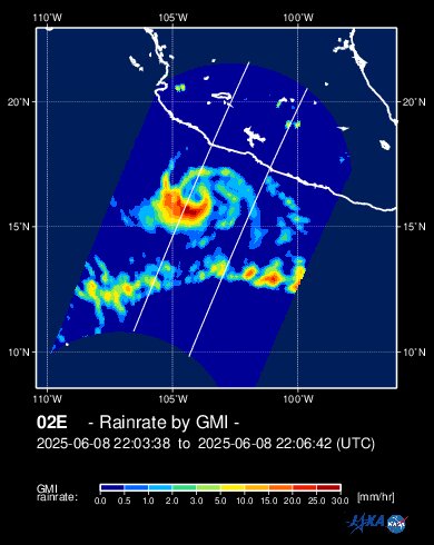
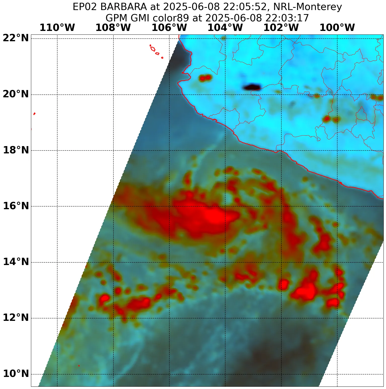
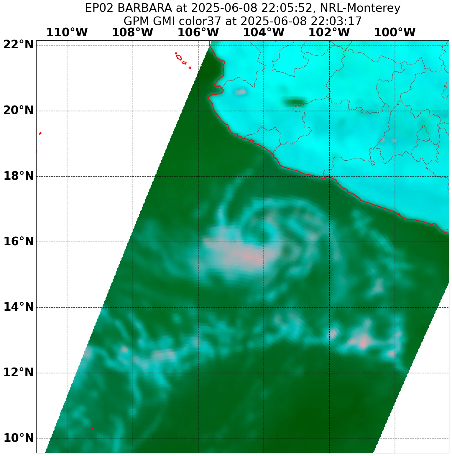
Barbara has become better organized as depicted in an earlier AMSR2
microwave pass, which shows the low-level center tucked under a
large central dense overcast. The microwave imagery also indicates
that a partial eyewall has formed, although it was open on the
northern side. The latest subjective Dvorak estimate from TAFB was
T4.0/65 kt, and the objective satellite intensity aids from UW-CIMSS
range from 55-65 kt. Using a blend of these estimates, the initial
intensity is increased to 65 kt for this advisory. This makes
Barbara the first hurricane of the 2025 east Pacific hurricane
season.

The storm is estimated to be moving more northwestward at 310/9 kt.
Barbara continues to be steered by a mid-level ridge located over
Mexico and it should continue to move northwestward over the next
few days. The GFS and ECMWF models continue to be on opposite sides
of the guidance envelope, and this is mainly due to differences in
when Barbara weakens and becomes steered by the low-level wind flow.
The latest NHC track forecast was shifted slightly to the right,
closer to the simple and corrected consensus.

Barbara is likely near its peak intensity, as it only has about 6-12
more hours of a favorable environment. Along the forecast track, the
system will be crossing over increasingly cooler sea surface
temperatures overnight. Around the same time, the mid-level relative
humidity values will begin to drop. This will cause the system to
steadily weaken and lose convective organization. The storm is now
forecast to become post-tropical in 36 h, and dissipate into an open
trough by 60 h.


FORECAST POSITIONS AND MAX WINDS

INIT 09/1500Z 17.6N 106.1W 65 KT 75 MPH
12H 10/0000Z 18.4N 107.2W 65 KT 75 MPH
24H 10/1200Z 19.6N 108.2W 50 KT 60 MPH
36H 11/0000Z 20.8N 109.3W 35 KT 40 MPH...POST-TROPICAL
48H 11/1200Z 21.2N 110.0W 25 KT 30 MPH...POST-TROP/REMNT LOW
60H 12/0000Z...DISSIPATED

$$
Forecaster Kelly/E.Adams
0 likes   

Sciencerocks
Category 5
Category 5
Posts: 9152
Age: 39
Joined: Thu Jul 06, 2017 1:51 am

Re: EPAC: BARBARA - Tropical Storm - Discussion

#59 Postby Sciencerocks » Mon Jun 09, 2025 10:25 am

Image
0 likes   

User avatar
Yellow Evan
Professional-Met
Professional-Met
Posts: 16143
Age: 27
Joined: Fri Jul 15, 2011 12:48 pm
Location: Henderson, Nevada/Honolulu, HI
Contact:

Re: EPAC: BARBARA - Tropical Storm - Discussion

#60 Postby Yellow Evan » Mon Jun 09, 2025 6:55 pm

394
WTPZ42 KNHC 092032
TCDEP2

Hurricane Barbara Discussion Number 7
NWS National Hurricane Center Miami FL EP022025
200 PM MST Mon Jun 09 2025

Since the last advisory Barbara has become a little less organized.
Latest GOES satellite imagery depicts the system starting to ingest
some drier air which has caused fragmented banding. However, a
central dense overcast has remained over the tiny inner core. The
satellite intensity estimates have decreased slightly from the
previous advisory ranging from 50 to 65 kt. Using these estimates,
the intensity is held at 65 kt, although this may be generous.

A mid-level ridge located over Mexico should continue to steer the
system northwestward over the next couple of days. As Barbara begins
to weaken into a shallow vortex and slow down, it will be steered by
the low-level wind flow. The latest NHC track forecast is similar to
the previous one, and close to the simple and corrected consensus.

Barbara likely has peaked as a short-lived hurricane. The
environmental conditions will becoming increasingly hostile along
the forecast track with the storm crossing into cooler SSTs and into
a drier, more stable air mass. This will cause the system to
steadily weaken, lose convective organization, and become post
tropical by 36 h. The latest NHC forecast shows the system opening
into a trough by 60 h and dissipating.

FORECAST POSITIONS AND MAX WINDS

INIT 09/2100Z 18.2N 106.8W 65 KT 75 MPH
12H 10/0600Z 19.2N 107.9W 55 KT 65 MPH
24H 10/1800Z 20.5N 109.1W 40 KT 45 MPH
36H 11/0600Z 21.4N 110.0W 30 KT 35 MPH...POST-TROP/REMNT LOW
48H 11/1800Z 21.8N 110.6W 20 KT 25 MPH...POST-TROP/REMNT LOW
60H 12/0600Z...DISSIPATED

$$
Forecaster Mora/Kelly
0 likes   


Return to “2025”

Who is online

Users browsing this forum: No registered users and 1 guest