2025 EPAC Season
Moderator: S2k Moderators
Forum rules

The posts in this forum are NOT official forecasts and should not be used as such. They are just the opinion of the poster and may or may not be backed by sound meteorological data. They are NOT endorsed by any professional institution or STORM2K. For official information, please refer to products from the National Hurricane Center and National Weather Service.
-
Kingarabian

- S2K Supporter

- Posts: 16376
- Joined: Sat Aug 08, 2009 3:06 am
- Location: Honolulu, Hawaii
Re: 2025 EPAC Season
Euro and GFS both showing a 2nd system in less than 10 days.
0 likes
RIP Kobe Bryant
-
cycloneye

- Admin

- Posts: 149675
- Age: 69
- Joined: Thu Oct 10, 2002 10:54 am
- Location: San Juan, Puerto Rico
Re: 2025 EPAC Season
12z Euro.

2 likes
Visit the Caribbean-Central America Weather Thread where you can find at first post web cams,radars
and observations from Caribbean basin members Click Here
and observations from Caribbean basin members Click Here
-
cycloneye
- Admin
- Posts: 149675
- Age: 69
- Joined: Thu Oct 10, 2002 10:54 am
- Location: San Juan, Puerto Rico
Re: 2025 EPAC Season
Offshore of Central America and Southern Mexico:
An area of low pressure could form by the middle part of next week
offshore of the coasts of Central America and southern Mexico.
Environmental conditions appear favorable for some development of
this system thereafter while it moves generally westward to
west-northwestward at around 10 to 15 mph.
* Formation chance through 48 hours...low...near 0 percent.
* Formation chance through 7 days...low...20 percent.

0 likes
Visit the Caribbean-Central America Weather Thread where you can find at first post web cams,radars
and observations from Caribbean basin members Click Here
and observations from Caribbean basin members Click Here
-
AnnularCane

- S2K Supporter
- Posts: 2964
- Joined: Thu Jun 08, 2006 9:18 am
- Location: Wytheville, VA
Re: 2025 EPAC Season
Not wasting time. 
0 likes
"But it never rained rain. It never snowed snow. And it never blew just wind. It rained things like soup and juice. It snowed mashed potatoes and green peas. And sometimes the wind blew in storms of hamburgers." -- Judi Barrett, Cloudy with a Chance of Meatballs
-
Yellow Evan

- Professional-Met

- Posts: 16257
- Age: 27
- Joined: Fri Jul 15, 2011 12:48 pm
- Location: Henderson, Nevada/Honolulu, HI
- Contact:
Re: 2025 EPAC Season
Need genesis by 100W if they want to become anything like the GFS depictions but most likely TCG will get delayed and the GFS/GEFS will downtrend accordingly.
2 likes
-
cycloneye
- Admin
- Posts: 149675
- Age: 69
- Joined: Thu Oct 10, 2002 10:54 am
- Location: San Juan, Puerto Rico
Re: 2025 EPAC Season
Tropical Weather Outlook
NWS National Hurricane Center Miami FL
500 AM PDT Fri May 30 2025
For the eastern North Pacific...east of 140 degrees west longitude:
Active Systems:
The National Hurricane Center is issuing advisories on Tropical
Storm Alvin, located a few hundred miles offshore the coast of
southwestern Mexico.
1. Offshore of Central America and Southern Mexico:
An area of low pressure could form by the middle part of next week
offshore of the coasts of Central America and southern Mexico.
Environmental conditions appear favorable for some development of
this system thereafter while it moves generally westward to
west-northwestward at around 10 to 15 mph.
* Formation chance through 48 hours...low...near 0 percent.
* Formation chance through 7 days...low...20 percent.
Forecaster Hagen

0 likes
Visit the Caribbean-Central America Weather Thread where you can find at first post web cams,radars
and observations from Caribbean basin members Click Here
and observations from Caribbean basin members Click Here

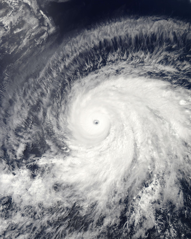
Re: 2025 EPAC Season
We will see whether future Barbara will recapture her 2019 beauty. Probably not if we follow the recent Euro solutions, but may have a chance if GFS is right this time.
5 likes
TC naming lists: retirements and intensity
Most aggressive Advisory #1's in North Atlantic (cr. kevin for starting the list)
Most aggressive Advisory #1's in North Atlantic (cr. kevin for starting the list)
-
cycloneye
- Admin
- Posts: 149675
- Age: 69
- Joined: Thu Oct 10, 2002 10:54 am
- Location: San Juan, Puerto Rico
Re: 2025 EPAC Season
I am a little surprised of the fast start of the EPAC 2025 season given the expectations that it would not be very active per NOAA Outlook. if the future system develops like GFS and ECMWF, the ACE will be plenty.
1 likes
Visit the Caribbean-Central America Weather Thread where you can find at first post web cams,radars
and observations from Caribbean basin members Click Here
and observations from Caribbean basin members Click Here
-
cycloneye
- Admin
- Posts: 149675
- Age: 69
- Joined: Thu Oct 10, 2002 10:54 am
- Location: San Juan, Puerto Rico
Re: 2025 EPAC Season
Tropical Weather Outlook
NWS National Hurricane Center Miami FL
1100 AM PDT Fri May 30 2025
For the eastern North Pacific...east of 140 degrees west longitude:
Active Systems:
The National Hurricane Center is issuing advisories on Tropical
Storm Alvin, located a few hundred miles offshore the coast of
southwestern and west-central Mexico.
Offshore of Central America and Southern Mexico:
An area of low pressure could form by the middle part of next week
offshore of the coasts of Central America and southern Mexico.
Environmental conditions appear favorable for some development of
this system thereafter while it moves generally westward to
west-northwestward at around 10 to 15 mph.
* Formation chance through 48 hours...low...near 0 percent.
* Formation chance through 7 days...low...30 percent.
$$
Forecaster Hagen

0 likes
Visit the Caribbean-Central America Weather Thread where you can find at first post web cams,radars
and observations from Caribbean basin members Click Here
and observations from Caribbean basin members Click Here
-
Kingarabian
- S2K Supporter
- Posts: 16376
- Joined: Sat Aug 08, 2009 3:06 am
- Location: Honolulu, Hawaii
Re: 2025 EPAC Season
Teban54 wrote:We will see whether future Barbara will recapture her 2019 beauty. Probably not if we follow the recent Euro solutions, but may have a chance if GFS is right this time.
https://i.postimg.cc/5yBxXCzW/1920px-Barbara-2019-07-02-2145-Z.jpg
I'm baffled that it wasn't declared a Cat.5 at its peak. Beautiful storm.
1 likes
RIP Kobe Bryant
-
Hurricane2022

- Category 5

- Posts: 2088
- Joined: Tue Aug 23, 2022 11:38 pm
- Location: Araçatuba, Brazil
Re: 2025 EPAC Season
cycloneye wrote:I am a little surprised of the fast start of the EPAC 2025 season given the expectations that it would not be very active per NOAA Outlook. if the future system develops like GFS and ECMWF, the ACE will be plenty.
2010 also had a very fast start
1 likes
Sorry for the bad English sometimes...!
For reliable and detailed information for any meteorological phenomenon, please consult the National Hurricane Center, Joint Typhoon Warning Center , or your local Meteo Center.
--------
ECCE OMNIA NOVA FACIAM (Ap 21,5).
For reliable and detailed information for any meteorological phenomenon, please consult the National Hurricane Center, Joint Typhoon Warning Center , or your local Meteo Center.
--------
ECCE OMNIA NOVA FACIAM (Ap 21,5).
-
cycloneye
- Admin
- Posts: 149675
- Age: 69
- Joined: Thu Oct 10, 2002 10:54 am
- Location: San Juan, Puerto Rico
Re: 2025 EPAC Season
Tropical Weather Outlook
NWS National Hurricane Center Miami FL
500 PM PDT Fri May 30 2025
For the eastern North Pacific...east of 140 degrees west longitude:
Active Systems:
The National Hurricane Center is issuing advisories on Tropical
Storm Alvin, located a few hundred miles south of the southern tip
of the Baja California peninsula.
1. Offshore of Central America and Southern Mexico:
An area of low pressure could form by the middle part of next week
offshore of the coasts of Central America and southern Mexico.
Environmental conditions appear favorable for some development of
this system thereafter while it moves generally westward to
west-northwestward at around 10 to 15 mph.
* Formation chance through 48 hours...low...near 0 percent.
* Formation chance through 7 days...low...30 percent.
Forecaster Cangialosi

0 likes
Visit the Caribbean-Central America Weather Thread where you can find at first post web cams,radars
and observations from Caribbean basin members Click Here
and observations from Caribbean basin members Click Here
-
cycloneye
- Admin
- Posts: 149675
- Age: 69
- Joined: Thu Oct 10, 2002 10:54 am
- Location: San Juan, Puerto Rico
Re: 2025 EPAC Season
Euro ensembles are very active with the NHC 30% AOI and maybe another one?

1 likes
Visit the Caribbean-Central America Weather Thread where you can find at first post web cams,radars
and observations from Caribbean basin members Click Here
and observations from Caribbean basin members Click Here
-
Yellow Evan
- Professional-Met
- Posts: 16257
- Age: 27
- Joined: Fri Jul 15, 2011 12:48 pm
- Location: Henderson, Nevada/Honolulu, HI
- Contact:
Re: 2025 EPAC Season
Kingarabian wrote:Teban54 wrote:We will see whether future Barbara will recapture her 2019 beauty. Probably not if we follow the recent Euro solutions, but may have a chance if GFS is right this time.
https://i.postimg.cc/5yBxXCzW/1920px-Barbara-2019-07-02-2145-Z.jpg
I'm baffled that it wasn't declared a Cat.5 at its peak. Beautiful storm.
SAB infamously fixed a 6.5 for an embedded W.
Somehow not even the strongest Barbara imo - honor goes to the 1983 version.
0 likes
-
cycloneye
- Admin
- Posts: 149675
- Age: 69
- Joined: Thu Oct 10, 2002 10:54 am
- Location: San Juan, Puerto Rico
Re: 2025 EPAC Season
Tropical Weather Outlook
NWS National Hurricane Center Miami FL
500 AM PDT Sat May 31 2025
For the eastern North Pacific...east of 140 degrees west longitude:
Active Systems:
The National Hurricane Center is issuing advisories on Tropical
Storm Alvin, located a couple of hundred miles south of the
southern tip of the Baja California peninsula.
1. Offshore of Central America and Southern Mexico:
An area of low pressure is likely to form by the middle part of next
week offshore of the coasts of Central America and southern Mexico.
Environmental conditions appear favorable for some development of
this system thereafter, and a tropical depression could form late
next week while it moves generally westward to west-northwestward at
around 5 to 10 mph.
* Formation chance through 48 hours...low...near 0 percent.
* Formation chance through 7 days...medium...40 percent.
Forecaster Hagen

0 likes
Visit the Caribbean-Central America Weather Thread where you can find at first post web cams,radars
and observations from Caribbean basin members Click Here
and observations from Caribbean basin members Click Here
-
cycloneye
- Admin
- Posts: 149675
- Age: 69
- Joined: Thu Oct 10, 2002 10:54 am
- Location: San Juan, Puerto Rico
Re: 2025 EPAC Season
Tropical Weather Outlook
NWS National Hurricane Center Miami FL
1100 AM PDT Sat May 31 2025
For the eastern North Pacific...east of 140 degrees west longitude:
Active Systems:
The National Hurricane Center has issued the last advisory on
Post-Tropical Cyclone Alvin, located a little more than 100 miles
south of the southern tip of the Baja California peninsula.
Offshore of Central America and Southern Mexico:
An area of low pressure is likely to form by the middle part of next
week offshore of the coasts of Central America and southern Mexico.
Environmental conditions appear favorable for some development of
this system thereafter, and a tropical depression could form late
next week while it moves generally westward to west-northwestward at
around 5 to 10 mph.
* Formation chance through 48 hours...low...near 0 percent.
* Formation chance through 7 days...medium...40 percent.
$$
Forecaster Hagen

0 likes
Visit the Caribbean-Central America Weather Thread where you can find at first post web cams,radars
and observations from Caribbean basin members Click Here
and observations from Caribbean basin members Click Here
-
Kingarabian
- S2K Supporter
- Posts: 16376
- Joined: Sat Aug 08, 2009 3:06 am
- Location: Honolulu, Hawaii
Re: 2025 EPAC Season
Both Euro and GFS solutions aren't supportive of intense systems. Euro has delayed development meaning it reaches cooler water quicker. GFS has two systems that hug the coast and would allow land interaction and dry air to limit development.
1 likes
RIP Kobe Bryant
-
cycloneye
- Admin
- Posts: 149675
- Age: 69
- Joined: Thu Oct 10, 2002 10:54 am
- Location: San Juan, Puerto Rico
Re: 2025 EPAC Season
Tropical Weather Outlook
NWS National Hurricane Center Miami FL
500 PM PDT Sat May 31 2025
For the eastern North Pacific...east of 140 degrees west longitude:
1. South of Central America and Southern Mexico:
An area of low pressure is forecast to form offshore of the coast of
Central America and southern Mexico by the middle part of next week.
Environmental conditions appear conducive for gradual development of
this system thereafter, and a tropical depression could form late
next week while it moves generally westward to west-northwestward
around 10 mph.
* Formation chance through 48 hours...low...near 0 percent.
* Formation chance through 7 days...medium...40 percent.
Forecaster Kelly
0 likes
Visit the Caribbean-Central America Weather Thread where you can find at first post web cams,radars
and observations from Caribbean basin members Click Here
and observations from Caribbean basin members Click Here
-
cycloneye
- Admin
- Posts: 149675
- Age: 69
- Joined: Thu Oct 10, 2002 10:54 am
- Location: San Juan, Puerto Rico
Re: 2025 EPAC Season
Tropical Weather Outlook
NWS National Hurricane Center Miami FL
500 AM PDT Sun Jun 1 2025
For the eastern and central North Pacific east of 180 longitude:
South of Central America and Southern Mexico:
An area of low pressure is forecast to form offshore of the coast of
Central America and southern Mexico during the middle to late
portions of this week. Once it forms, the disturbance is expected to
move generally westward to west-northwestward around 10 mph.
Environmental conditions are expected to be at least marginally
conducive for slow development of this system, and a tropical
depression could form by the end of the week.
* Formation chance through 48 hours...low...near 0 percent.
* Formation chance through 7 days...medium...40 percent.
$$
Forecaster D. Zelinsky
0 likes
Visit the Caribbean-Central America Weather Thread where you can find at first post web cams,radars
and observations from Caribbean basin members Click Here
and observations from Caribbean basin members Click Here
-
StormWeather

- Category 1

- Posts: 477
- Joined: Wed Jun 05, 2024 2:34 pm
Re: 2025 EPAC Season
cycloneye wrote:I am a little surprised of the fast start of the EPAC 2025 season given the expectations that it would not be very active per NOAA Outlook. if the future system develops like GFS and ECMWF, the ACE will be plenty.
Well it is a complete 180 from last year, that’s for sure.
0 likes
Just an average cyclone tracker
The posts in this forum are NOT official forecasts and should not be used as such. They are just the opinion of the poster and may or may not be backed by sound meteorological data. They are NOT endorsed by any professional institution or storm2k.org. For official information, please refer to the NHC and NWS products
The posts in this forum are NOT official forecasts and should not be used as such. They are just the opinion of the poster and may or may not be backed by sound meteorological data. They are NOT endorsed by any professional institution or storm2k.org. For official information, please refer to the NHC and NWS products
Who is online
Users browsing this forum: gib and 219 guests