Texas Spring 2025
Moderator: S2k Moderators
Forum rules

The posts in this forum are NOT official forecast and should not be used as such. They are just the opinion of the poster and may or may not be backed by sound meteorological data. They are NOT endorsed by any professional institution or STORM2K.

Re: Texas Spring 2025
Current radar showing the rain mostly avoiding the upper colorado basin yet again; some storms moving in from the south though, over the Pedernales. Maybe today will slow down the rate of loss. Lakes gonna be empty by the end of summer at this rate.
0 likes
-
txtwister78

- Category 5

- Posts: 2204
- Joined: Wed Jan 30, 2019 12:56 pm
- Location: San Antonio
Re: Texas Spring 2025
Well we got some showers this morning as advertised via the models so check on that front
SPC has upgraded the SA metro to a slight risk today however short range hi-res models are beginning to show a chance for isolated supercell development out west late tonight over Del Rio possibly impacting the SA metro after midnight.
That trend will need to be watched as all modes of severe weather would be possible including tornadoes should a storm or two develop.
0 likes
Re: Texas Spring 2025
Nice downpour just ended in East Austin. All the local sites seem offline, but I'd guess almost an inch.
0 likes

-
jasons2k

- Storm2k Executive

- Posts: 8290
- Age: 52
- Joined: Wed Jul 06, 2005 12:32 pm
- Location: The Woodlands, TX
Re: Texas Spring 2025
Severe Thunderstorm Watch Number 225
NWS Storm Prediction Center Norman OK
155 PM CDT Mon May 5 2025
The NWS Storm Prediction Center has issued a
* Severe Thunderstorm Watch for portions of Southeast Texas
* Effective this Monday afternoon and evening from 155 PM until 800 PM CDT.
* Primary threats include... Scattered large hail and isolated very large hail events to 2.5 inches in diameter possible Isolated damaging wind gusts to 70 mph possible A tornado or two possible
SUMMARY...An intense supercell will likely pose a threat for large to very large hail up to 1.5 to 2.5 inches in diameter as it tracks east-southeastward towards the Houston metro area over the next few hours. Additional robust thunderstorms may also develop through the rest of the afternoon into early evening.
The severe thunderstorm watch area is approximately along and 50 statute miles east and west of a line from 5 miles northeast of College Station TX to 40 miles west southwest of Houston TX. For a complete depiction of the watch see the associated watch outline update (WOUS64 KWNS WOU5).
PRECAUTIONARY/PREPAREDNESS ACTIONS...
REMEMBER...A Severe Thunderstorm Watch means conditions are favorable for severe thunderstorms in and close to the watch area. Persons in these areas should be on the lookout for threatening weather conditions and listen for later statements and possible warnings. Severe thunderstorms can and occasionally do produce tornadoes.
&&
OTHER WATCH INFORMATION...CONTINUE...WW 223...WW 224...
AVIATION...A few severe thunderstorms with hail surface and aloft to 2.5 inches. Extreme turbulence and surface wind gusts to 60 knots. A few cumulonimbi with maximum tops to 500. Mean storm motion vector 28030.
...Gleason
0 likes
-
txtwister78
- Category 5
- Posts: 2204
- Joined: Wed Jan 30, 2019 12:56 pm
- Location: San Antonio
Re: Texas Spring 2025
Cpv17 wrote:wxman22 wrote:Stratton23 wrote:Enjoy the rain while we can everyone! Looks like the wet weather pattern comes to an end mid week as ridging pretty much takes over the central US , a sign that summer is coming
Models are actually hinting at the dryline becoming active in west/northwest Texas and points north into the central plains after mid month. With surface cyclogenesis frequently taking place on the lee side of the Rockies. That's a classic setup in traditional tornado alley this time of year. The pattern will be drier overall as QPF wont be nearly as widespread as it's been lately. As such a pattern would favor more scattered and diurnal driven discreet supercells instead of the large MCS's of lately. And would probably favor mainly the western 1/3rd of the state QPF wise due to the location of the dryline. Climatology speaking this is a very typical pattern in mid to late May.
So yes things look to become drier as we head deeper into May. But the severe weather risk may actually go up in traditional tornado alley. You'll also notice even the low resolution global models this far out, are already seeing storms firing along the dryline in the Plains after the 15th or so. Could be a good time for the chasers lol. We'll see.
Boring pattern for most of Texas after the middle of this week. Hopefully I can get another inch this week before the dry period sets in cuz no telling when it’ll rain again.
I'm good with boring as long as it's warm/sunny...
0 likes
-
Stratton23
- Category 5
- Posts: 3563
- Joined: Fri Jul 21, 2023 10:59 pm
- Location: Katy, Tx

Re: Texas Spring 2025
We got seriously upgraded, like I thought we would. TxTwisterr78, what's your analysis for today? How much trouble is Central Texas in? Porta? I don't like that hatch area... 
0 likes
-
TomballEd
- Category 5
- Posts: 1294
- Age: 62
- Joined: Wed Aug 16, 2023 4:52 pm
- Location: Spring/Klein area, not Tomball
Re: Texas Spring 2025
Last edited by TomballEd on Tue May 06, 2025 8:06 am, edited 1 time in total.
0 likes
-
TomballEd
- Category 5
- Posts: 1294
- Age: 62
- Joined: Wed Aug 16, 2023 4:52 pm
- Location: Spring/Klein area, not Tomball
Re: Texas Spring 2025
2 hours from now San Antonio (KSAT) 6Z run 3 km NAM forecast sounding. Tame low level instability but 8C/Km lapse rates and total totals of 57 are no joke.

0 likes
-
wxman22

- Category 5
- Posts: 1956
- Joined: Mon Jan 30, 2006 12:39 am
- Location: Wichita Falls, TX
- Contact:
Re: Texas Spring 2025
Stay weather aware today especially in SE Texas. Enhanced risk issued for tornadoes and wind.
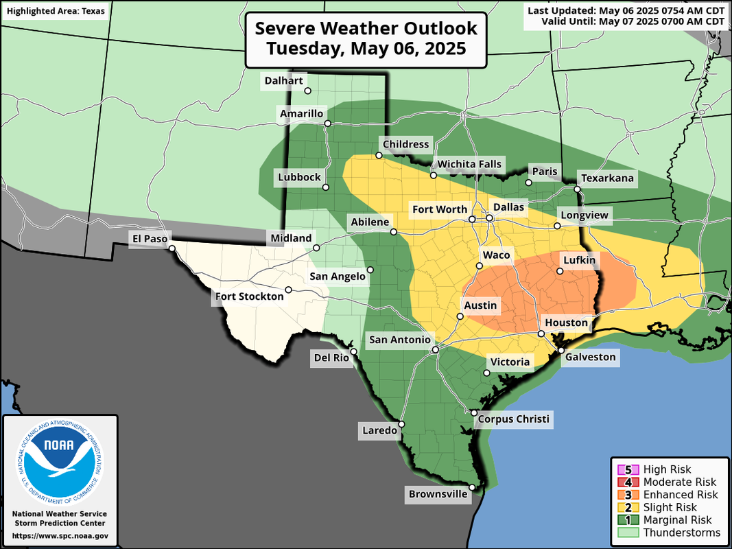
Day 1 Convective Outlook
NWS Storm Prediction Center Norman OK
0754 AM CDT Tue May 06 2025
Valid 061300Z - 071200Z
...THERE IS AN ENHANCED RISK OF SEVERE THUNDERSTORMS ACROSS CENTRAL
AND EAST/SOUTHEAST TEXAS TO WESTERN LOUISIANA...
...THERE IS A SLIGHT RISK OF SEVERE THUNDERSTORMS ACROSS PARTS OF
THE NORTHEAST...
...SUMMARY...
Severe thunderstorms are expected today into this evening especially
across central into east/southeast Texas into Louisiana. Large to
very large hail, damaging winds, and tornadoes, potentially a few of
which may be strong, can be expected. Severe storms may also occur
across parts of the Northeast and the Florida Peninsula.
...Southern Plains/Lower Mississippi Valley...
Strengthening cyclonic southwesterly flow aloft/mid-level jet streak
will overspread an increasingly moist boundary layer that will exist
along/north of a northward-shifting warm front across central/east
Texas into Louisiana. Of primary concern is potential supercell
development near the warm front and just ahead of the surface wave,
which could materialize relatively early today. Ample
deep-layer/low-level shear will support the supercell potential with
risks for large to very large hail, damaging winds, as well as
tornadoes, including strong tornado potential. This will be in the
presence of upwards of 2500-4000 J/kg MLCAPE and 40-55 kt effective
shear, with low-level SRH maximized in the
east/northeastward-transitioning low-level jet axis and in proximity
to the warm front. Other more elevated storms are expected north of
the warm front, with large hail most common, but some wind potential
as well even with slightly elevated storms. A mixed mode of storms
including embedded supercells and MCS development/persistence is
expected into Louisiana by evening.
0 likes
-
jasons2k
- Storm2k Executive
- Posts: 8290
- Age: 52
- Joined: Wed Jul 06, 2005 12:32 pm
- Location: The Woodlands, TX
Re: Texas Spring 2025
URGENT - IMMEDIATE BROADCAST REQUESTED
Tornado Watch Number 231
NWS Storm Prediction Center Norman OK
815 AM CDT Tue May 6 2025
The NWS Storm Prediction Center has issued a
* Tornado Watch for portions of
Central and East/Southeast Texas
* Effective this Tuesday morning and afternoon from 815 AM until
400 PM CDT.
* Primary threats include...
A few tornadoes likely with a couple intense tornadoes possible
Scattered large hail likely with isolated very large hail events
to 3 inches in diameter possible
Scattered damaging wind gusts to 70 mph likely
SUMMARY...Supercell thunderstorms are expected to develop near a
warm front across the region with other storms related to an
eastward-moving cluster of storms across central Texas early today.
Tornado potential is apparent, including the possibility of strong
tornadoes. Damaging winds and large hail are also expected.
The tornado watch area is approximately along and 65 statute miles
north and south of a line from 65 miles north northwest of San
Antonio TX to 35 miles southeast of Huntsville TX. For a complete
depiction of the watch see the associated watch outline update
(WOUS64 KWNS WOU1).
PRECAUTIONARY/PREPAREDNESS ACTIONS...
REMEMBER...A Tornado Watch means conditions are favorable for
tornadoes and severe thunderstorms in and close to the watch
area. Persons in these areas should be on the lookout for
threatening weather conditions and listen for later statements
and possible warnings.
&&
OTHER WATCH INFORMATION...CONTINUE...WW 230...
AVIATION...Tornadoes and a few severe thunderstorms with hail
surface and aloft to 3 inches. Extreme turbulence and surface wind
gusts to 60 knots. A few cumulonimbi with maximum tops to 550. Mean
storm motion vector 24025.
...Guyer
0 likes
Re: Texas Spring 2025
Nice rains this morning with more on the way. Potent system swinging through with the cooler than average temps keeping the severe threat checked. Earlier this morning Santa Fe New Mexico was snowing at 35 degrees!! How's that for early May??
0 likes
-
txtwister78
- Category 5
- Posts: 2204
- Joined: Wed Jan 30, 2019 12:56 pm
- Location: San Antonio
Re: Texas Spring 2025
NWS has extended the severe thunderstorm watch for counties just west of SA until noon and as mentioned above SPC issued a tornado watch for counties east and ne into the Austin metro.
Interesting that Bexar County is in the middle of that with no watch designation? Not sure how that one works but nonetheless need to keep an eye out for the line of storms to our west within the next hour or so to see if that intensifies as it pushes east.
Interesting that Bexar County is in the middle of that with no watch designation? Not sure how that one works but nonetheless need to keep an eye out for the line of storms to our west within the next hour or so to see if that intensifies as it pushes east.
0 likes


Re: Texas Spring 2025
Very heavy rain, wind moving in. Hoping for a good inch or so. Quite cool around 60F.
1 likes
The above post and any post by Ntxw is NOT an official forecast and should not be used as such. It is just the opinion of the poster and may or may not be backed by sound meteorological data. It is NOT endorsed by any professional institution including Storm2k. For official information, please refer to NWS products.
Help support Storm2K!
-
rwfromkansas
- Category 5
- Posts: 3038
- Joined: Sat Aug 27, 2005 12:47 am
- Location: North Fort Worth
Re: Texas Spring 2025
Up to 1.25. Another downpour. One of the darkest day storms I’ve seen. Looked like night.
1 likes
-
TomballEd
- Category 5
- Posts: 1294
- Age: 62
- Joined: Wed Aug 16, 2023 4:52 pm
- Location: Spring/Klein area, not Tomball
Re: Texas Spring 2025
Storms just N of Houston metro could be big hail producers judging by HRRR around lunch time.
0 likes
Return to “USA & Caribbean Weather”
Who is online
Users browsing this forum: No registered users and 53 guests