Texas Spring 2025

U.S. & Caribbean Weather Discussions and Severe Weather Events

Moderator: S2k Moderators

Forum rules

The posts in this forum are NOT official forecast and should not be used as such. They are just the opinion of the poster and may or may not be backed by sound meteorological data. They are NOT endorsed by any professional institution or STORM2K.

Help Support Storm2K
Message
Author
User avatar
Cpv17
Category 5
Category 5
Posts: 4979
Joined: Wed Dec 07, 2016 2:24 pm
Location: Wharton/El Campo, TX

Re: Texas Spring 2025

#1021 Postby Cpv17 » Sat May 03, 2025 1:41 pm

Stratton23 wrote:Hopefully central texas and se texas can cash in even more on the rain next week, because it does appears the pattern flips to much drier conditions beyond next weeks storm system


Yep, I was thinking the same thing.
0 likes   

User avatar
wxman22
Category 5
Category 5
Posts: 1492
Joined: Mon Jan 30, 2006 12:39 am
Location: Wichita Falls, TX
Contact:

Re: Texas Spring 2025

#1022 Postby wxman22 » Sat May 03, 2025 7:05 pm

It feels like early Fall today. And with the upcoming period of NW/Northly flow aloft on the backside of the cutoff trough later next week, it may stay cool at least until mid month. Subject to change of course.
1 likes   

HockeyTx82
S2K Supporter
S2K Supporter
Posts: 2540
Joined: Tue Oct 27, 2009 11:17 am
Location: Ponder, TX

Re: Texas Spring 2025

#1023 Postby HockeyTx82 » Sat May 03, 2025 11:43 pm

wxman22 wrote:It feels like early Fall today. And with the upcoming period of NW/Northly flow aloft on the backside of the cutoff trough later next week, it may stay cool at least until mid month. Subject to change of course.


Great Hockey Weather!

What a game!!!!!! Go Stars!!!!!
1 likes   
Don't hold me accountable for anything I post on this forum. Leave the real forecasting up to the professionals.

Location: Ponder, TX (all observation posts are this location unless otherwise noted)

Brent
S2K Supporter
S2K Supporter
Posts: 38090
Age: 36
Joined: Sun May 16, 2004 10:30 pm
Location: Tulsa Oklahoma
Contact:

Re: Texas Spring 2025

#1024 Postby Brent » Sun May 04, 2025 7:29 am

wxman22 wrote:It feels like early Fall today. And with the upcoming period of NW/Northly flow aloft on the backside of the cutoff trough later next week, it may stay cool at least until mid month. Subject to change of course.


Fine by me but then again apparently it snowed here in May 2013 :lol:

Also the last time we had an ef5 tornado :spam: hope that doesn't mean anything :eek: we actually haven't had a big severe day here yet and hopefully it stays that way
0 likes   
#neversummer

TomballEd
Category 2
Category 2
Posts: 699
Age: 61
Joined: Wed Aug 16, 2023 4:52 pm
Location: Spring/Klein area, not Tomball

Re: Texas Spring 2025

#1025 Postby TomballEd » Sun May 04, 2025 9:01 am

SPC SWODY 3 wording sounds ominous. Just a SLIGHT RISK at this time. But it may go up as Tuesday gets closer.

...Central Texas into Sabine Valley...
The expectation of early day precipitation complicates the overall
forecast for the afternoon. Even so, a very moist and weakly capped
airmass is forecast to be in place south of the warm front and east
of the developing dryline. The ECMWF is more aggressive with the
early development of a cluster of storms/MCS. In this scenario,
convection would likely strengthen as surface heating occurs ahead
of it. The GFS/NAM show greater potential for the dryline to be a
focus for convection during the afternoon. Here, supercells capable
of all hazards would be possible. There is potential for significant
severe, with very large hail being the primary concern
, but
uncertainty in the convective evolution keeps confidence too low to
highlight any particularly area.
1 likes   

User avatar
TexasF6
S2K Supporter
S2K Supporter
Posts: 816
Joined: Mon Aug 09, 2004 9:33 pm
Location: Austin, TX

Re: Texas Spring 2025

#1026 Postby TexasF6 » Sun May 04, 2025 11:26 am

TomballEd wrote:SPC SWODY 3 wording sounds ominous. Just a SLIGHT RISK at this time. But it may go up as Tuesday gets closer.

...Central Texas into Sabine Valley...
The expectation of early day precipitation complicates the overall
forecast for the afternoon. Even so, a very moist and weakly capped
airmass is forecast to be in place south of the warm front and east
of the developing dryline. The ECMWF is more aggressive with the
early development of a cluster of storms/MCS. In this scenario,
convection would likely strengthen as surface heating occurs ahead
of it. The GFS/NAM show greater potential for the dryline to be a
focus for convection during the afternoon. Here, supercells capable
of all hazards would be possible. There is potential for significant
severe, with very large hail being the primary concern
, but
uncertainty in the convective evolution keeps confidence too low to
highlight any particularly area.


I looked at several models and yikes!!! 4.50in hail and tornadoes possible...bears watching!
1 likes   

User avatar
txtwister78
Category 5
Category 5
Posts: 1855
Joined: Wed Jan 30, 2019 12:56 pm
Location: San Antonio

Re: Texas Spring 2025

#1027 Postby txtwister78 » Sun May 04, 2025 11:27 am

Good news is we could see some showers tomorrow across SC TX in the afternoon. The bad news is rainfall amounts per current hi-res models look minimal.

In addition to that, models don't seem to be all that bullish regarding severe weather tomorrow which is a good thing obviously but that also cuts back on rainfall totals as a result.

Once again real-time observations such as how much cloud cover will be in place to limit temps/instability and for how long will likely play a significant role on rainfall amounts early next week. We should see better odds of course as the front moves across the state Tuesday but SC TX appears to be the southern end of that for the time being but hopefully that changes.
0 likes   

User avatar
txtwister78
Category 5
Category 5
Posts: 1855
Joined: Wed Jan 30, 2019 12:56 pm
Location: San Antonio

Re: Texas Spring 2025

#1028 Postby txtwister78 » Sun May 04, 2025 11:51 am

TexasF6 wrote:
TomballEd wrote:SPC SWODY 3 wording sounds ominous. Just a SLIGHT RISK at this time. But it may go up as Tuesday gets closer.

...Central Texas into Sabine Valley...
The expectation of early day precipitation complicates the overall
forecast for the afternoon. Even so, a very moist and weakly capped
airmass is forecast to be in place south of the warm front and east
of the developing dryline. The ECMWF is more aggressive with the
early development of a cluster of storms/MCS. In this scenario,
convection would likely strengthen as surface heating occurs ahead
of it. The GFS/NAM show greater potential for the dryline to be a
focus for convection during the afternoon. Here, supercells capable
of all hazards would be possible. There is potential for significant
severe, with very large hail being the primary concern
, but
uncertainty in the convective evolution keeps confidence too low to
highlight any particularly area.


I looked at several models and yikes!!! 4.50in hail and tornadoes possible...bears watching!


I don't know which models you're referring to but despite better lift Tuesday courtesy of the frontal boundary, I would say anything rising to that level of severe is going to be highly conditional on the timing of storms (early morning vs afternoon), cloud cover that will either limit instability/temps or allow atmosphere to destabilize should we have less and what if any outflow boundaries are in place from any previous storm activity.

Again all highly conditional/uncertain that SPC acknowledges and therfore has kept slight risk in place for now.
1 likes   

rwfromkansas
Category 5
Category 5
Posts: 2627
Joined: Sat Aug 27, 2005 12:47 am
Location: North Fort Worth

Re: Texas Spring 2025

#1029 Postby rwfromkansas » Sun May 04, 2025 12:20 pm

Red River nearing record 1983 flood levels.
1 likes   

User avatar
TexasF6
S2K Supporter
S2K Supporter
Posts: 816
Joined: Mon Aug 09, 2004 9:33 pm
Location: Austin, TX

Re: Texas Spring 2025

#1030 Postby TexasF6 » Sun May 04, 2025 1:03 pm

txtwister78 wrote:
TexasF6 wrote:
TomballEd wrote:SPC SWODY 3 wording sounds ominous. Just a SLIGHT RISK at this time. But it may go up as Tuesday gets closer.

...Central Texas into Sabine Valley...
The expectation of early day precipitation complicates the overall
forecast for the afternoon. Even so, a very moist and weakly capped
airmass is forecast to be in place south of the warm front and east
of the developing dryline. The ECMWF is more aggressive with the
early development of a cluster of storms/MCS. In this scenario,
convection would likely strengthen as surface heating occurs ahead
of it. The GFS/NAM show greater potential for the dryline to be a
focus for convection during the afternoon. Here, supercells capable
of all hazards would be possible. There is potential for significant
severe, with very large hail being the primary concern
, but
uncertainty in the convective evolution keeps confidence too low to
highlight any particularly area.


I looked at several models and yikes!!! 4.50in hail and tornadoes possible...bears watching!


I don't know which models you're referring to but despite better lift Tuesday courtesy of the frontal boundary, I would say anything rising to that level of severe is going to be highly conditional on the timing of storms (early morning vs afternoon), cloud cover that will either limit instability/temps or allow atmosphere to destabilize should we have less and what if any outflow boundaries are in place from any previous storm activity.

Again all highly conditional/uncertain that SPC acknowledges and therfore has kept slight risk in place for now.


NAM, GFS, and even the Canadian models showed potential for severe weather. May in Texas is always primetime for severe weather. Pivotal Weather has runs available if you need any additional resources.
1 likes   

User avatar
txtwister78
Category 5
Category 5
Posts: 1855
Joined: Wed Jan 30, 2019 12:56 pm
Location: San Antonio

Re: Texas Spring 2025

#1031 Postby txtwister78 » Sun May 04, 2025 1:20 pm

TexasF6 wrote:
txtwister78 wrote:
TexasF6 wrote:
I looked at several models and yikes!!! 4.50in hail and tornadoes possible...bears watching!


I don't know which models you're referring to but despite better lift Tuesday courtesy of the frontal boundary, I would say anything rising to that level of severe is going to be highly conditional on the timing of storms (early morning vs afternoon), cloud cover that will either limit instability/temps or allow atmosphere to destabilize should we have less and what if any outflow boundaries are in place from any previous storm activity.

Again all highly conditional/uncertain that SPC acknowledges and therfore has kept slight risk in place for now.


NAM, GFS, and even the Canadian models showed potential for severe weather. May in Texas is always primetime for severe weather. Pivotal Weather has runs available if you need any additional resources.


Yeah I know where to find those obviously but what I was referring to was the "tornado risk and hail up to 4.50 inches" comment that you attributed to the models.

That's why I raised the conditional aspect of SPC's comment regarding their own uncertainty. Definitely a wait and see situation in other words based on all the factors I mentioned above (cloud cover etc). Hi-res typically does a better job at this range with specifics and atmospheric dynamics. We shall see
Last edited by txtwister78 on Sun May 04, 2025 4:43 pm, edited 1 time in total.
0 likes   

User avatar
wxman22
Category 5
Category 5
Posts: 1492
Joined: Mon Jan 30, 2006 12:39 am
Location: Wichita Falls, TX
Contact:

Re: Texas Spring 2025

#1032 Postby wxman22 » Sun May 04, 2025 2:09 pm

Enhanced Risk issued in West Texas tomorrow.

Image

Image

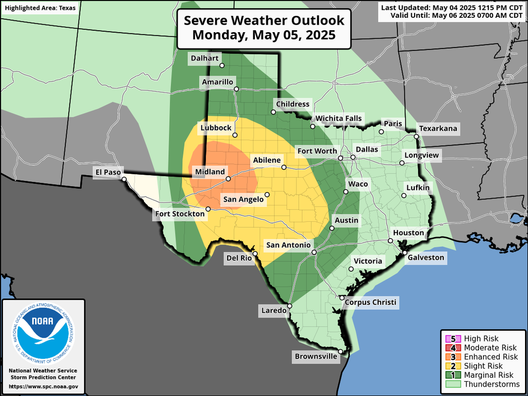
Day 2 Convective Outlook
NWS Storm Prediction Center Norman OK
1215 PM CDT Sun May 04 2025

Valid 051200Z - 061200Z

...THERE IS AN ENHANCED RISK OF SEVERE THUNDERSTORMS ACROSS FAR
SOUTHEAST NEW MEXICO INTO SOUTHWEST TEXAS...

...SUMMARY...
Severe thunderstorms are expected from the southern High Plains into
parts of central Texas Monday afternoon and evening. Scattered large
to very large hail and severe winds are the primary threats, though
a couple of tornadoes also are possible. Additional strong to severe
storms are possible along the eastern Florida coast and from
northeast North Carolina to the Lake Erie vicinity.

...Synopsis...

A pair of upper cyclones, one over the Ohio Valley and the other
across the Southwest, will pivot east on Monday. These systems will
support a belt of enhanced mid/upper flow across the southern
Rockies/High Plains and the Mid-Atlantic/Lower Great Lakes. At the
surface, a cold front will stretch from the Mid-Atlantic
south/southwest into north-central FL. Meanwhile, a dryline is
forecast to develop across eastern NM and southwest TX, while a warm
front lifts slowly northward across northwest and central TX. These
features will focus potential for severe thunderstorms Monday
afternoon into the evening/overnight.

...Southeast NM into Central TX...

Southeasterly low-level flow will transport 60s F dewpoints
northwest toward southeast NM into the Trans-Pecos vicinity ahead of
a sharpening dryline. Strong heating along/just behind the dryline
will foster moderate diurnal destabilization as deep-layer flow
strengthens. Forecast hodographs initially will be
elongated/straight through the afternoon and early evening.
Splitting supercells produce large/very large hail are expected with
initial convection. Furthermore, steep low-level lapse rates where
stronger heating occurs also could support strong/severe gusts.

During the evening, a low-level jet will increase, resulting in
enlarged/curved low-level hodographs. Additional rounds of
supercells may develop as the dryline begins to retreat and stronger
ascent overspreads the region. This activity will continue to pose a
significant hail risk with an increasing risk for a couple of
tornadoes. As the upper low draws closer to the southern Rockies
during the nighttime hours, weak cyclogenesis may occur over far
southwest TX. Additional thunderstorm clusters, possibly growing
upscale into an MCS propagating along the higher theta-e gradient
across west-central to central TX is possible. It is uncertain how
intense this convection may become given multiple rounds of
convection across parts of the area earlier in the day, but some
risk for damaging gusts and a tornado or two will persist.
0 likes   

Stratton23
Category 5
Category 5
Posts: 2520
Joined: Fri Jul 21, 2023 10:59 pm
Location: Katy, Tx

Re: Texas Spring 2025

#1033 Postby Stratton23 » Sun May 04, 2025 2:48 pm

Enjoy the rain while we can everyone! Looks like the wet weather pattern comes to an end mid week as ridging pretty much takes over the central US , a sign that summer is coming
0 likes   

User avatar
cheezyWXguy
Category 5
Category 5
Posts: 6108
Joined: Mon Feb 13, 2006 12:29 am
Location: Dallas, TX

Re: Texas Spring 2025

#1034 Postby cheezyWXguy » Sun May 04, 2025 4:58 pm

If the 18z HRRR’s scenario is repeated in future runs, the severe risk will need to be expanded northward into dfw. Supercells breaking out ahead of the line with a pretty decent wind profile for some tornado threat.
0 likes   

User avatar
txtwister78
Category 5
Category 5
Posts: 1855
Joined: Wed Jan 30, 2019 12:56 pm
Location: San Antonio

Re: Texas Spring 2025

#1035 Postby txtwister78 » Sun May 04, 2025 5:20 pm

RRFS new run definitely showing the conditional severe weather possibility for Tuesday morning into afternoon across central, portions of SC and east TX. One run and so need to see what are WRF members show later tonight along with future HRRR runs which aren't as bullish yet.

Image
1 likes   

User avatar
wxman22
Category 5
Category 5
Posts: 1492
Joined: Mon Jan 30, 2006 12:39 am
Location: Wichita Falls, TX
Contact:

Re: Texas Spring 2025

#1036 Postby wxman22 » Sun May 04, 2025 8:26 pm

Stratton23 wrote:Enjoy the rain while we can everyone! Looks like the wet weather pattern comes to an end mid week as ridging pretty much takes over the central US , a sign that summer is coming


Models are actually hinting at the dryline becoming active in west/northwest Texas and points north into the central plains after mid month. With surface cyclogenesis frequently taking place on the lee side of the Rockies. That's a classic setup in traditional tornado alley this time of year. The pattern will be drier overall as QPF wont be nearly as widespread as it's been lately. As such a pattern would favor more scattered and diurnal driven discreet supercells instead of the large MCS's of lately. And would probably favor mainly the western 1/3rd of the state QPF wise due to the location of the dryline. Climatology speaking this is a very typical pattern in mid to late May.

So yes things look to become drier as we head deeper into May. But the severe weather risk may actually go up in traditional tornado alley. You'll also notice even the low resolution global models this far out, are already seeing storms firing along the dryline in the Plains after the 15th or so. Could be a good time for the chasers lol. We'll see. :)
1 likes   

Brent
S2K Supporter
S2K Supporter
Posts: 38090
Age: 36
Joined: Sun May 16, 2004 10:30 pm
Location: Tulsa Oklahoma
Contact:

Re: Texas Spring 2025

#1037 Postby Brent » Sun May 04, 2025 9:20 pm

wxman22 wrote:
Stratton23 wrote:Enjoy the rain while we can everyone! Looks like the wet weather pattern comes to an end mid week as ridging pretty much takes over the central US , a sign that summer is coming


Models are actually hinting at the dryline becoming active in west/northwest Texas and points north into the central plains after mid month. With surface cyclogenesis frequently taking place on the lee side of the Rockies. That's a classic setup in traditional tornado alley this time of year. The pattern will be drier overall as QPF wont be nearly as widespread as it's been lately. As such a pattern would favor more scattered and diurnal driven discreet supercells instead of the large MCS's of lately. And would probably favor mainly the western 1/3rd of the state QPF wise due to the location of the dryline. Climatology speaking this is a very typical pattern in mid to late May.

So yes things look to become drier as we head deeper into May. But the severe weather risk may actually go up in traditional tornado alley. You'll also notice even the low resolution global models this far out, are already seeing storms firing along the dryline in the Plains after the 15th or so. Could be a good time for the chasers lol. We'll see. :)
.

Yeah the chasers I know here are quite annoyed with this pattern :lol: sucks for them

But to be fair everything here has been a quick linear spinup at 6am or.just a flood so far

Of course our two worst severe events in Tulsa itself have been in June so we've got a long way to go
0 likes   
#neversummer

User avatar
Cpv17
Category 5
Category 5
Posts: 4979
Joined: Wed Dec 07, 2016 2:24 pm
Location: Wharton/El Campo, TX

Re: Texas Spring 2025

#1038 Postby Cpv17 » Sun May 04, 2025 10:11 pm

wxman22 wrote:
Stratton23 wrote:Enjoy the rain while we can everyone! Looks like the wet weather pattern comes to an end mid week as ridging pretty much takes over the central US , a sign that summer is coming


Models are actually hinting at the dryline becoming active in west/northwest Texas and points north into the central plains after mid month. With surface cyclogenesis frequently taking place on the lee side of the Rockies. That's a classic setup in traditional tornado alley this time of year. The pattern will be drier overall as QPF wont be nearly as widespread as it's been lately. As such a pattern would favor more scattered and diurnal driven discreet supercells instead of the large MCS's of lately. And would probably favor mainly the western 1/3rd of the state QPF wise due to the location of the dryline. Climatology speaking this is a very typical pattern in mid to late May.

So yes things look to become drier as we head deeper into May. But the severe weather risk may actually go up in traditional tornado alley. You'll also notice even the low resolution global models this far out, are already seeing storms firing along the dryline in the Plains after the 15th or so. Could be a good time for the chasers lol. We'll see. :)


Boring pattern for most of Texas after the middle of this week. Hopefully I can get another inch this week before the dry period sets in cuz no telling when it’ll rain again.
0 likes   

TomballEd
Category 2
Category 2
Posts: 699
Age: 61
Joined: Wed Aug 16, 2023 4:52 pm
Location: Spring/Klein area, not Tomball

Re: Texas Spring 2025

#1039 Postby TomballEd » Mon May 05, 2025 8:18 am

SWODY 2 sounds like another chance of Enhanced Risk by tomorrow, uncertainty is high about whether there will be an MCS tomorrow morning and how that develops. Sig Severe hail for the I-10 area from the Hill Country into the W half of the Houston metro. New HRRR and 6Z 3 km NAM shows showers/storms today that may prep the E half of Texas for flooding tomorrow.

3km NAM sounding in the warm sector ahead of the line lunch time near I-35/ACT. The saving grace is small low level instability. Even so, STP is very high. Total Totals also suggest hail potential.

Given the weakly capped boundary layer even early in the day, there
is reasonable confidence in numerous storms, particularly along the
warm front. With large amounts of storm interference possible, on
top of potential MCS, confidence is not high enough to increase
tornado probabilities. Concerning the MCS and greater severe wind
potential, models vary greatly on the placement of this feature.
Similarly, confidence is too low for higher wind probabilities as
well. Overall, scattered to numerous storms along the warm front and
dryline in central Texas will be capable of all severe hazards. Very
large hail is most likely along the dryline or with storms that
develop along the southern edge of any MCS.


Image
0 likes   

User avatar
wxman22
Category 5
Category 5
Posts: 1492
Joined: Mon Jan 30, 2006 12:39 am
Location: Wichita Falls, TX
Contact:

Re: Texas Spring 2025

#1040 Postby wxman22 » Mon May 05, 2025 8:36 am

A lot of flood watches issued. And the first round of rain is moving in.


Image

Image
1 likes   


Return to “USA & Caribbean Weather”

Who is online

Users browsing this forum: Brent and 22 guests