Most Infamous Cases of Rapid Intensification?

This is the general tropical discussion area. Anyone can take their shot at predicting a storms path.

Moderator: S2k Moderators

Forum rules

The posts in this forum are NOT official forecasts and should not be used as such. They are just the opinion of the poster and may or may not be backed by sound meteorological data. They are NOT endorsed by any professional institution or STORM2K. For official information, please refer to products from the National Hurricane Center and National Weather Service.

Help Support Storm2K
Message
Author
User avatar
WaveBreaking
Category 2
Category 2
Posts: 602
Joined: Sun Jun 30, 2024 11:33 am
Location: US

Most Infamous Cases of Rapid Intensification?

#1 Postby WaveBreaking » Fri Dec 13, 2024 9:50 am

Image
There have been countless instances of TCs undergoing RI in recent decades. The loop above (Maria ‘17’s first and second peaks as a Category 5) is a great example of this.

But to you all, which RI episodes were the most dramatic, impressive, and/or terrifying?
Last edited by WaveBreaking on Mon Dec 16, 2024 1:12 pm, edited 1 time in total.
7 likes   
I am NOT a professional meteorologist, so take all of my posts with a grain of salt. My opinions are mine and mine alone.

User avatar
Hurricane2022
Category 5
Category 5
Posts: 1645
Joined: Tue Aug 23, 2022 11:38 pm
Location: Araçatuba, Brazil

Re: Most Infamous Periods of Rapid Intensification?

#2 Postby Hurricane2022 » Fri Dec 13, 2024 10:02 am

Most insane RI episodes that I've tracked:
1st: Hurricanes Milton and Otis '23
3rd: Hurricane Jova '23
4th: STYs Noru '22 and Rai '21
6th: STY Bolaven '23 and Cyclone Ambali '19
3 likes   
Sorry for the bad English sometimes...!
For reliable and detailed information for any meteorological phenomenon, please consult the National Hurricane Center, Joint Typhoon Warning Center , or your local Meteo Center.

--------

Una cvm Christo, pro Christo, et in Christo. Sit nomen Domini benedictvm.

User avatar
Teban54
Category 5
Category 5
Posts: 3269
Joined: Sat May 19, 2018 1:19 pm

Re: Most Infamous Periods of Rapid Intensification?

#3 Postby Teban54 » Fri Dec 13, 2024 11:24 am

There are a lot of such examples from a meteorological perspective, but in terms of human impact, I doubt anything can ever top Otis. Absolutely nobody expected the TS to blow up into a Cat 5 in 24 hours, and then landfall on a major metropolitan area, until the RI was already underway.

Honorable mention goes to Milton. Similar story in forecasting, with nothing suggesting more than a TS/Cat 1 in the Gulf until less than 48 hours out, much less the first sub-900mb storm in almost 20 years. But it was at least more closely followed than Otis due to being in the Atlantic and threatening Florida.

Otherwise, the next most unexpected devastating RI in recent years was probably Harvey. The stalling and rainfall potential had been there, but models and NHC were both playing catchup with intensity big time.
7 likes   

User avatar
Category5Kaiju
Category 5
Category 5
Posts: 4163
Joined: Thu Dec 24, 2020 12:45 pm
Location: Seattle

Re: Most Infamous Periods of Rapid Intensification?

#4 Postby Category5Kaiju » Fri Dec 13, 2024 2:10 pm

Yeah, Otis is probably up there in being among the storms with the most impressive, dangerous, and shocking period of RI.

Not sure if there’s a meteorological term for it, but at least with storms like Beryl, Otis, Milton, and Harvey, I’ve noticed that their RI periods all started with this look where they looked like a circular blob, which then started to rotate.
5 likes   
Unless explicitly stated, all info in my posts is based on my own opinions and observations. Tropical storms and hurricanes can be extremely dangerous. Do not think you can beat Mother Nature. Refer to an accredited weather research agency or meteorologist if you need to make serious decisions regarding an approaching storm.

User avatar
WaveBreaking
Category 2
Category 2
Posts: 602
Joined: Sun Jun 30, 2024 11:33 am
Location: US

Re: Most Infamous Periods of Rapid Intensification?

#5 Postby WaveBreaking » Fri Dec 13, 2024 2:20 pm

The one that stuck out the most to me was Super Typhoon Surigae’s RI period where its entire CDO ballooned out and dropped below -80°C (yellow) in literal minutes. The cooling was so dramatic that it happened in under 15 frames on Himawari’s Mesoscale sector, and I’ve never seen anything like this with any other TC. It’s a good thing this never made landfall in the Philippines.

Image
13 likes   

I am NOT a professional meteorologist, so take all of my posts with a grain of salt. My opinions are mine and mine alone.

OtakuForecaster
Tropical Low
Tropical Low
Posts: 12
Joined: Mon Dec 02, 2024 9:44 am

Re: Most Infamous Periods of Rapid Intensification?

#6 Postby OtakuForecaster » Fri Dec 13, 2024 10:52 pm

WaveBreaking wrote:The one that stuck out the most to me was Super Typhoon Surigae’s RI period where its entire CDO ballooned out and dropped below -80°C (yellow) in literal minutes. The cooling was so dramatic that it happened in under 15 frames on Himawari’s Mesoscale sector, and I’ve never seen anything like this with any other TC. It’s a good thing this never made landfall in the Philippines.

https://i.imgur.com/nxrI7e9.gif


That's so astonishing and cool! Oh my god I'm like a little kid in a candy store even though I'm 33! :)

Thanks for sharing, bro!
2 likes   

User avatar
WaveBreaking
Category 2
Category 2
Posts: 602
Joined: Sun Jun 30, 2024 11:33 am
Location: US

Re: Most Infamous Periods of Rapid Intensification?

#7 Postby WaveBreaking » Mon Dec 16, 2024 8:52 am

Here are some other ones I can think of that come to mind.

Katrina (2005)
Everyone remembers what Katrina did to New Orleans, but I feel like not everyone remembers the few days before Katrina made landfall when it was rapidly strengthening and growing in size; eventually staring down Louisiana while having a pressure and windspeed second only to Camille in the GOM. The damage from Katrina was downright apocalyptic, but imagine how much worse it could have been if Katrina sustained its peak intensity.
Image


Wilma (2005)
Out of the four(!) category 5 hurricanes that formed in 2005, Wilma is always the one that always amazes me the most (which is a huge accomplishment considering what the other three cat 5s did). Its intensification rate was so high that its ridiculously small eye shows up in only a couple frames. The other thing that sets it apart from the others besides its record low pressure was how violent its original eye was. It never sat still and was always revolving around the storm’s common center.
Image


Harvey (2017)
Like Teban54 and Category5Kaiju have already mentioned, Harvey was expected to bring significant flooding to the Texas and the Houston area, but no one expected it to bounce back so quickly in intensity after it fell apart in the Caribbean. I honestly feel like not a lot of people talk about how last-second Harvey’s RI period was, even the satellite loop of it looks rushed.
Image


Dorian (2019)
For how spammy most of the storms from the 2019 season were, Dorian was a complete anomaly. It was able to keep itself together in a very dry environment and hook up with two upper-level lows to intensify to a historic landfall strength. Not to mention its horrific stall over the Bahamas while being mere miles away from the Florida East Coast.
Image


Otis (2023)
The definition of taking advantage of an opportunity. Won’t say anything else because everything else has already been said.
Image


Beryl (2024)
I will always remember waking up during summer break to a category 3 hurricane that I thought would only be a 1 nearly grazing South America in late June. Not even Beryl’s second strengthening period where it became a category 5 compares to the first period, because that first RI period was crazy fast and seemed to come out of nowhere, whereas the second period seemed to be the next natural step.
Image
9 likes   

I am NOT a professional meteorologist, so take all of my posts with a grain of salt. My opinions are mine and mine alone.

User avatar
WalterWhite
Category 1
Category 1
Posts: 342
Joined: Fri Mar 17, 2023 5:53 pm

Re: Most Infamous Periods of Rapid Intensification?

#8 Postby WalterWhite » Mon Dec 16, 2024 10:07 am

How has nobody mentioned Patricia (2015)?
4 likes   

User avatar
doomhaMwx
Category 5
Category 5
Posts: 2457
Age: 26
Joined: Tue Apr 18, 2017 4:01 am
Location: Baguio/Benguet, Philippines
Contact:

Re: Most Infamous Cases of Rapid Intensification?

#9 Postby doomhaMwx » Tue Dec 17, 2024 8:32 am

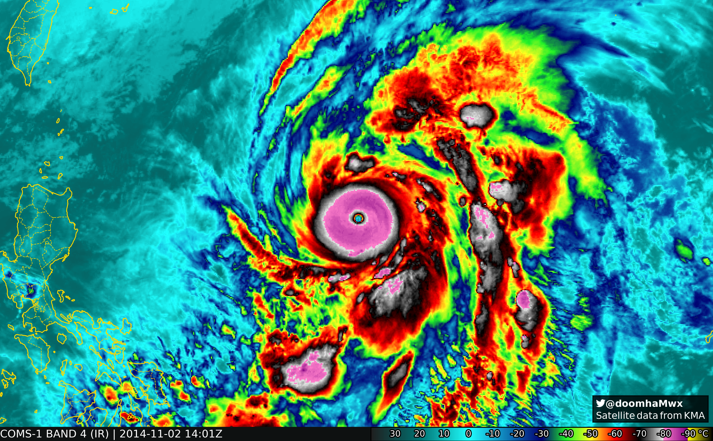
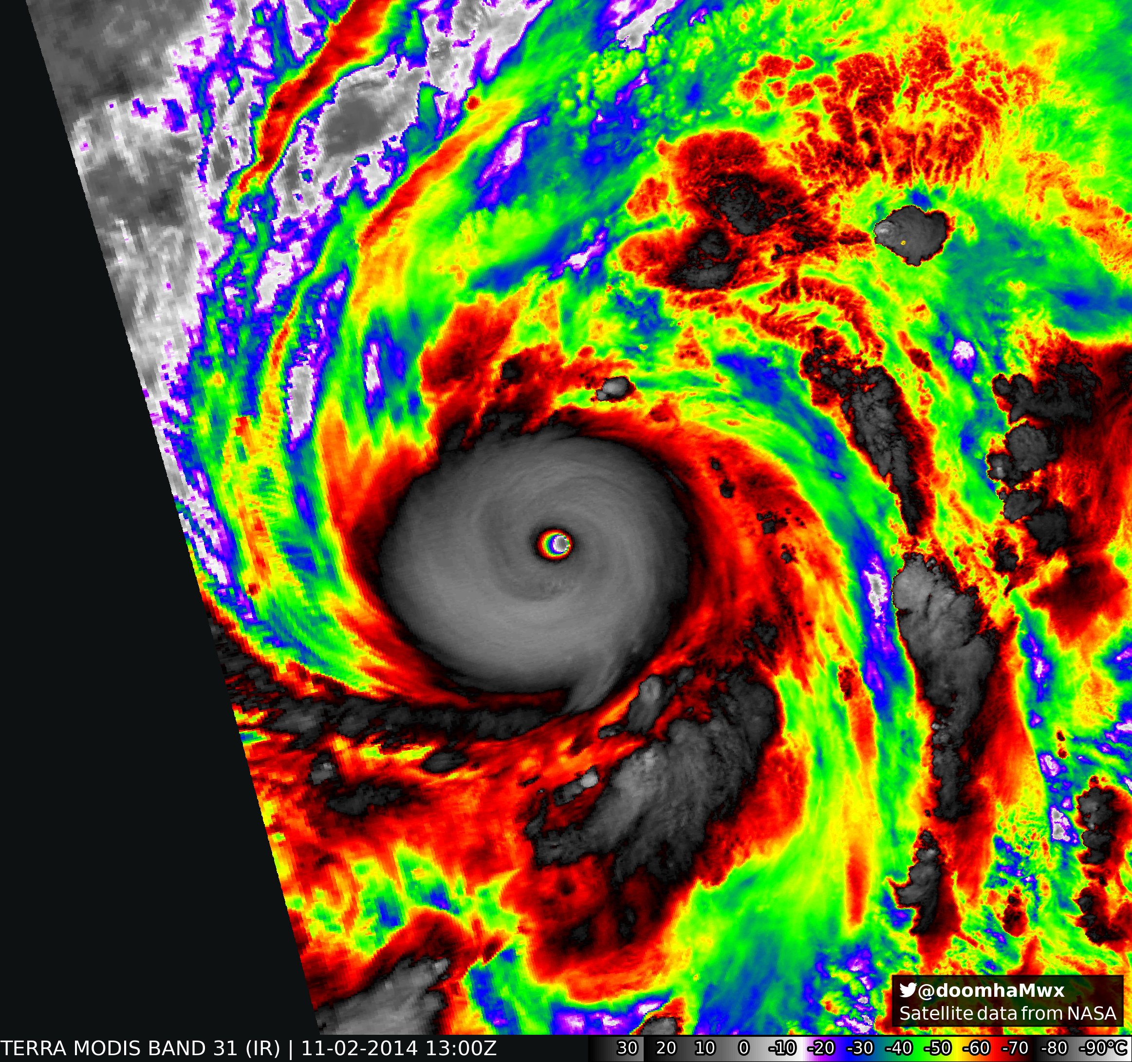
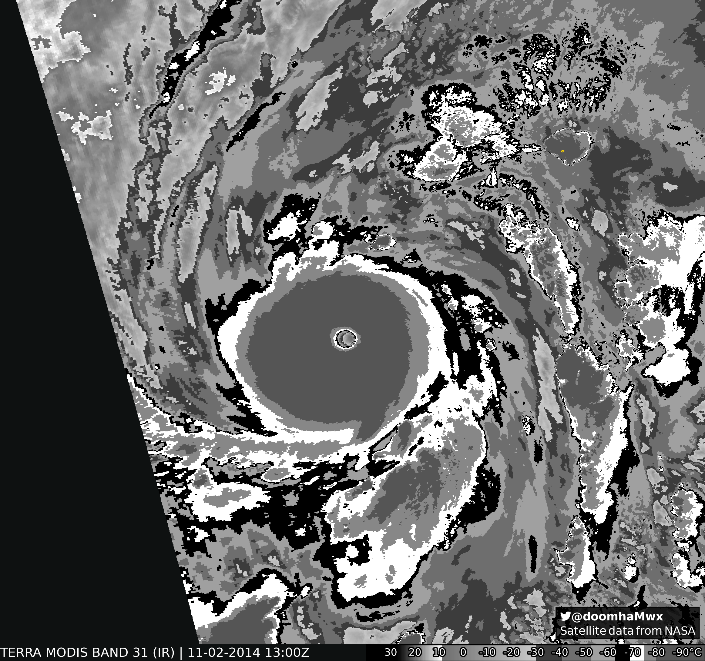
Supertyphoon Nuri (2014): Went from 65 to 155 kts in 30 hrs (might have even been stronger).

Image
Image
Image

 https://x.com/doomhaMwx/status/1852710251965075470

6 likes   

User avatar
Ptarmigan
Category 5
Category 5
Posts: 5325
Joined: Wed Aug 16, 2006 9:06 pm

Re: Most Infamous Periods of Rapid Intensification?

#10 Postby Ptarmigan » Sat Dec 28, 2024 9:49 pm

Category5Kaiju wrote:Yeah, Otis is probably up there in being among the storms with the most impressive, dangerous, and shocking period of RI.

Not sure if there’s a meteorological term for it, but at least with storms like Beryl, Otis, Milton, and Harvey, I’ve noticed that their RI periods all started with this look where they looked like a circular blob, which then started to rotate.


When I see a storm that is more circular in shape, that usually sets off my alarm for rapid intensification.
2 likes   

MarioProtVI
Category 4
Category 4
Posts: 950
Age: 24
Joined: Sun Sep 29, 2019 7:33 pm
Location: New Jersey

Re: Most Infamous Cases of Rapid Intensification?

#11 Postby MarioProtVI » Sun Feb 02, 2025 7:36 pm

Milton. No further words necessary. :lol:
8 likes   

Hurricane2000
Tropical Low
Tropical Low
Posts: 34
Joined: Sat Dec 28, 2024 4:50 pm

Re: Most Infamous Cases of Rapid Intensification?

#12 Postby Hurricane2000 » Mon Apr 14, 2025 8:33 pm

Definitely Hurricane Patricia, anyone got any imagery around its RI phase? It was crazy
2 likes   
Weather = Cool 8-)

Pas_Bon
Tropical Depression
Tropical Depression
Posts: 85
Age: 45
Joined: Mon Jul 15, 2019 12:25 pm
Location: League City, TX

Re: Most Infamous Cases of Rapid Intensification?

#13 Postby Pas_Bon » Wed Apr 16, 2025 9:31 am

WaveBreaking wrote:https://i.imgur.com/wP8CSXt.gif
There have been countless instances of TCs undergoing RI in recent decades. The loop above (Maria ‘17’s first and second peaks as a Category 5) is a great example of this.

But to you all, which RI episodes were the most dramatic, impressive, and/or terrifying?


The first first-hand experience I had with RI was with Lili in 2002.
I had traveled from college (LSU) to my parents' home in Vermilion Parish a couple days prior to help them prepare their home. During the day I got there, she had RI'd to 145/150mph sustained winds from a Cat 1 in mere hours.
Needless to say, I was petrified. Thankfully, she quickly relented prior to landfall, but I can remember the tree damage in my hometown was beyond anything I'd ever seen.
I was also a student in New Orleans in 2005 for Katrina and that RI in the Gulf was sobering.....followed soon by the RI of Rita.
I don't remember any instances of RI other than Gilbert in the late 1980's.
It seems RI is the norm these days, with slowly strengthening storms now thought of as anomalous.
1 likes   

User avatar
Yellow Evan
Professional-Met
Professional-Met
Posts: 16172
Age: 27
Joined: Fri Jul 15, 2011 12:48 pm
Location: Henderson, Nevada/Honolulu, HI
Contact:

Re: Most Infamous Cases of Rapid Intensification?

#14 Postby Yellow Evan » Wed Apr 16, 2025 12:05 pm

Errol can enter the conversation.
5 likes   

User avatar
WaveBreaking
Category 2
Category 2
Posts: 602
Joined: Sun Jun 30, 2024 11:33 am
Location: US

Re: Most Infamous Cases of Rapid Intensification?

#15 Postby WaveBreaking » Wed Apr 16, 2025 12:32 pm

Hurricane2000 wrote:Definitely Hurricane Patricia, anyone got any imagery around its RI phase? It was crazy

Image
3 likes   

I am NOT a professional meteorologist, so take all of my posts with a grain of salt. My opinions are mine and mine alone.

User avatar
Ulf
Tropical Low
Tropical Low
Posts: 36
Joined: Sun Nov 03, 2024 9:32 pm

Re: Most Infamous Cases of Rapid Intensification?

#16 Postby Ulf » Wed Apr 16, 2025 6:25 pm

I would say Joaquin is a candidate since it was originally a non-tropical low that was not expected by anyone to be more than a depression that would die to shears instead of the high-end Cat 4 it ended up becoming.
2 likes   

ljmac75
Tropical Storm
Tropical Storm
Posts: 145
Joined: Fri Apr 28, 2023 12:30 am

Re: Most Infamous Cases of Rapid Intensification?

#17 Postby ljmac75 » Sun Aug 17, 2025 10:29 am

3 likes   

User avatar
kevin
Category 5
Category 5
Posts: 2658
Age: 26
Joined: Wed Aug 28, 2019 4:35 am

Re: Most Infamous Cases of Rapid Intensification?

#18 Postby kevin » Wed Aug 20, 2025 2:52 am

Erin's ERI was nothing short of extraordinary and compared to other giants like Milton last year I feel we haven't really aknowledged it as such. In fact, I'd say Erin's ERI is even more impressive than Milton's or Lee's in terms of the intensification rate. While this isn't a statistic that's being tracked as far as I know, it only took Erin 6 hours to go from a cat 3 to a cat 5 and only 15 hours from a cat 1 to a cat 5. And while the hurricane did not surpass any of the Atlantic records, Erin came pretty close to Wilma's intensification records, see below. I added the 1520 UTC point as, in post-season, it'll most certainly be merged with the 1500 UTC data point.

Fastest intensification from a tropical storm to a Category 5 hurricane (1-minute sustained surface winds)
Wilma 2005 – 70 mph (110 km/h) to 175 mph (275 km/h) – from 0600 UTC October 18 to 0600 UTC October 19 - 24 hours
Erin 2025 - 70 mph (110 km/h) to 160 mph (255 km/h) - from 1200 UTC August 15 to 1520 UTC August 16 - 27 hours and 20 minutes

Maximum pressure drop in 12 hours
Wilma 2005 – 975 millibars to 892 millibars – from 1800 UTC October 18 to 0600 UTC October 19 - 83 milibars
Erin 2025 - 979 milibars to 917 milibars - from 0300 UTC August 16 to 1520 UTC August 16 - 62 milibars

Maximum pressure drop in 24 hours
Wilma 2005 – 979 millibars to 882 millibars – from 1200 UTC October 18 to 1200 UTC October 19 - 97 milibars
Erin 2025 - 996 milibars to 917 milibars - from 1500 UTC August 15 to 1520 UTC August 16 - 79 milibars
Last edited by kevin on Wed Aug 20, 2025 4:59 am, edited 1 time in total.
7 likes   

User avatar
REDHurricane
Category 1
Category 1
Posts: 415
Age: 28
Joined: Sun Jul 03, 2022 2:36 pm
Location: Northeast Pacific Ocean

Re: Most Infamous Cases of Rapid Intensification?

#19 Postby REDHurricane » Wed Aug 20, 2025 4:33 am

kevin wrote:Erin's ERI was nothing short of extraordinary and compared to other giants like Milton last year I feel we haven't really aknowledged it as such. In fact, I'd say Erin's ERI is even more impressive than Erin's or Lee's in terms of the intensification rate. While this isn't a statistic that's being tracked as far as I know, it only took Erin 6 hours to go from a cat 3 to a cat 5 and only 15 hours from a cat 1 to a cat 5. And while the hurricane did not surpass any of the Atlantic records, Erin came pretty close to Wilma's intensification records, see below. I added the 1520 UTC point as, in post-season, it'll most certainly be merged with the 1500 UTC data point.

Fastest intensification from a tropical storm to a Category 5 hurricane (1-minute sustained surface winds)
Wilma 2005 – 70 mph (110 km/h) to 175 mph (275 km/h) – from 0600 UTC October 18 to 0600 UTC October 19 - 24 hours
Erin 2025 - 70 mph (110 km/h) to 160 mph (255 km/h) - from 1200 UTC August 15 to 1520 UTC August 16 - 27 hours and 20 minutes

Maximum pressure drop in 12 hours
Wilma 2005 – 975 millibars to 892 millibars – from 1800 UTC October 18 to 0600 UTC October 19 - 83 milibars
Erin 2025 - 979 milibars to 917 milibars - from 0300 UTC August 16 to 1520 UTC August 16 - 62 milibars

Maximum pressure drop in 24 hours
Wilma 2005 – 979 millibars to 882 millibars – from 1200 UTC October 18 to 1200 UTC October 19 - 97 milibars
Erin 2025 - 996 milibars to 917 milibars - from 1500 UTC August 15 to 1520 UTC August 16 - 79 milibars


Yep, I think Erin will end up going down as one of the most underrated intensification periods of all time -- at least until there are multiple more like it -- because A) the models nailed down the (highly likely) OTS track very early on in the storm's life so people weren't really paying attention to it in the first place; B) there wasn't anything particularly memorable about the storm as a whole (i.e. wasn't Wilma, didn't go under 900mb like Milton, didn't set all the early season records like Beryl, didn't cause catastrophic damage anywhere, etc.); C) the ERI mainly took place in the overnight hours for the Caribbean/East Coast; and D) general fatigue from watching several previous ERI episodes (e.g. Milton, Lee, Beryl/Ian/Ida to some extent) just in the past few years. Thankfully my night owl self here on the West Coast was able to watch most of it as it transpired so I'll definitely remember how impressive it was, but I'm guessing it'll be largely overlooked/forgotten over the next however many years, even in weather enthusiast circles.
6 likes   

User avatar
Teban54
Category 5
Category 5
Posts: 3269
Joined: Sat May 19, 2018 1:19 pm

Re: Most Infamous Cases of Rapid Intensification?

#20 Postby Teban54 » Wed Aug 20, 2025 8:23 am

REDHurricane wrote:
kevin wrote:Erin's ERI was nothing short of extraordinary and compared to other giants like Milton last year I feel we haven't really aknowledged it as such. In fact, I'd say Erin's ERI is even more impressive than Erin's or Lee's in terms of the intensification rate. While this isn't a statistic that's being tracked as far as I know, it only took Erin 6 hours to go from a cat 3 to a cat 5 and only 15 hours from a cat 1 to a cat 5. And while the hurricane did not surpass any of the Atlantic records, Erin came pretty close to Wilma's intensification records, see below. I added the 1520 UTC point as, in post-season, it'll most certainly be merged with the 1500 UTC data point.

Fastest intensification from a tropical storm to a Category 5 hurricane (1-minute sustained surface winds)
Wilma 2005 – 70 mph (110 km/h) to 175 mph (275 km/h) – from 0600 UTC October 18 to 0600 UTC October 19 - 24 hours
Erin 2025 - 70 mph (110 km/h) to 160 mph (255 km/h) - from 1200 UTC August 15 to 1520 UTC August 16 - 27 hours and 20 minutes

Maximum pressure drop in 12 hours
Wilma 2005 – 975 millibars to 892 millibars – from 1800 UTC October 18 to 0600 UTC October 19 - 83 milibars
Erin 2025 - 979 milibars to 917 milibars - from 0300 UTC August 16 to 1520 UTC August 16 - 62 milibars

Maximum pressure drop in 24 hours
Wilma 2005 – 979 millibars to 882 millibars – from 1200 UTC October 18 to 1200 UTC October 19 - 97 milibars
Erin 2025 - 996 milibars to 917 milibars - from 1500 UTC August 15 to 1520 UTC August 16 - 79 milibars


Yep, I think Erin will end up going down as one of the most underrated intensification periods of all time -- at least until there are multiple more like it -- because A) the models nailed down the (highly likely) OTS track very early on in the storm's life so people weren't really paying attention to it in the first place; B) there wasn't anything particularly memorable about the storm as a whole (i.e. wasn't Wilma, didn't go under 900mb like Milton, didn't set all the early season records like Beryl, didn't cause catastrophic damage anywhere, etc.); C) the ERI mainly took place in the overnight hours for the Caribbean/East Coast; and D) general fatigue from watching several previous ERI episodes (e.g. Milton, Lee, Beryl/Ian/Ida to some extent) just in the past few years. Thankfully my night owl self here on the West Coast was able to watch most of it as it transpired so I'll definitely remember how impressive it was, but I'm guessing it'll be largely overlooked/forgotten over the next however many years, even in weather enthusiast circles.

Even Lee feels almost forgotten by now, and that was from just 2 years ago.
2 likes   


Return to “Talkin' Tropics”

Who is online

Users browsing this forum: Hurricane2022, Hypercane_Kyle and 63 guests