https://x.com/AndyHazelton/status/1855969286021402978
Potential development over the Western Caribbean Sea (Is Invest 99L)
Moderator: S2k Moderators
Forum rules

The posts in this forum are NOT official forecasts and should not be used as such. They are just the opinion of the poster and may or may not be backed by sound meteorological data. They are NOT endorsed by any professional institution or STORM2K. For official information, please refer to products from the National Hurricane Center and National Weather Service.
-
cycloneye

- Admin

- Posts: 149682
- Age: 69
- Joined: Thu Oct 10, 2002 10:54 am
- Location: San Juan, Puerto Rico
Re: Potential development over the western Caribbean Sea (0/40)
1 likes
Visit the Caribbean-Central America Weather Thread where you can find at first post web cams,radars
and observations from Caribbean basin members Click Here
and observations from Caribbean basin members Click Here
Re: Potential development over the western Caribbean Sea (0/40)
xironman wrote:Looking at the 850 vorticity on the models it looks like this area gets drawn into the CAG to help spark genesis. Nice sharp trough. Pretty unusual to have two majors in the Atlantic Basin in Nov.
https://i.imgur.com/UoIXicJ.gif
Unfortunately not impossible tho. How long will this keep up?
0 likes
-
toad strangler

- S2K Supporter

- Posts: 4546
- Joined: Sun Jul 28, 2013 3:09 pm
- Location: Earth
- Contact:
Re: Potential development over the western Caribbean Sea (0/40)
I'd like to think that whatever comes of this goes much further S & E than what the 6z GFS shows. (Sorry Cuba) The 0z Euro is more believable when factoring in climo. But I know, 2024 could just decide to do 2024. 
1 likes
My Weather Station
https://www.wunderground.com/dashboard/pws/KFLPORTS603
https://www.wunderground.com/dashboard/pws/KFLPORTS603
-
SFLcane

- S2K Supporter
- Posts: 10281
- Age: 48
- Joined: Sat Jun 05, 2010 1:44 pm
- Location: Lake Worth Florida
Re: Potential development over the western Caribbean Sea (0/40)
toad strangler wrote:I'd like to think that whatever comes of this goes much further S & E than what the 6z GFS shows. (Sorry Cuba) The 0z Euro is more believable when factoring in climo. But I know, 2024 could just decide to do 2024.
meh, climo and 2024 don't go together when you got west moving hurricanes in the gulf in early Nov. We are acting more like early/mid Oct if anything.
2 likes
Re: Potential development over the western Caribbean Sea (0/40)
underthwx wrote:xironman wrote:Looking at the 850 vorticity on the models it looks like this area gets drawn into the CAG to help spark genesis. Nice sharp trough. Pretty unusual to have two majors in the Atlantic Basin in Nov.
https://i.imgur.com/UoIXicJ.gif
Unfortunately not impossible tho. How long will this keep up?
I don't know, but if it was September there would be a lot more conversation on this one. I think we may see a hint at a recon flight on Wednesday today.

1 likes

Re: Potential development over the western Caribbean Sea (0/40)
Even the strongest model runs like the 12z GFS and 00z Euro have genesis take place very close to Central America as the disturbance rotates within a broader gyre. Any slight difference in this setup could mean the difference between a gyre dying over land or a strong TC developing. Could get another Nadine or another Rafael out of this.
3 likes
Irene '11 Sandy '12 Hermine '16 5/15/2018 Derecho Fay '20 Isaias '20 Elsa '21 Henri '21 Ida '21
I am only a meteorology enthusiast who knows a decent amount about tropical cyclones. Look to the professional mets, the NHC, or your local weather office for the best information.
I am only a meteorology enthusiast who knows a decent amount about tropical cyclones. Look to the professional mets, the NHC, or your local weather office for the best information.
Re: Potential development over the western Caribbean Sea (0/40)
kevin wrote:Here's a list of hurricanes which have made landfall in southern Florida from the west in November/December:
*
No that's not a typo, there is no historical precedence for this. The only thing close would be Kate 1985, which made landfall in the Panhandle as a cat 2. Despite all of the craziness so far this season such as Beryl and Milton, this potential late-season November hurricane might end up becoming the most anomalous storm of the season.
Would have never believed anything could beat Beryl or Milton, yet here we are!
1 likes
Cleo - 1964, Betsy - 1965, David - 1979, Andrew - 1992, Charlie (Francis, Ivan, Jeanne) - 2004, Irma - 2017, Ian - 2022, Milton - 2024

Re: Potential development over the western Caribbean Sea (0/40)
You'd think there would be some more discussion on this one given its potential threat to FL. Guess most people are tapped out for the season, hope they aren't in for a nasty surprise.
7 likes
Igor 2010, Sandy 2012, Fay 2014, Gonzalo 2014, Joaquin 2015, Nicole 2016, Humberto 2019, Imelda 2025
I am only a tropical weather enthusiast. My predictions are not official and may or may not be backed by sound meteorological data. For official information, please refer to the NHC and NWS products.
I am only a tropical weather enthusiast. My predictions are not official and may or may not be backed by sound meteorological data. For official information, please refer to the NHC and NWS products.
-
gatorcane

- S2K Supporter
- Posts: 23708
- Age: 48
- Joined: Sun Mar 13, 2005 3:54 pm
- Location: Boca Raton, FL
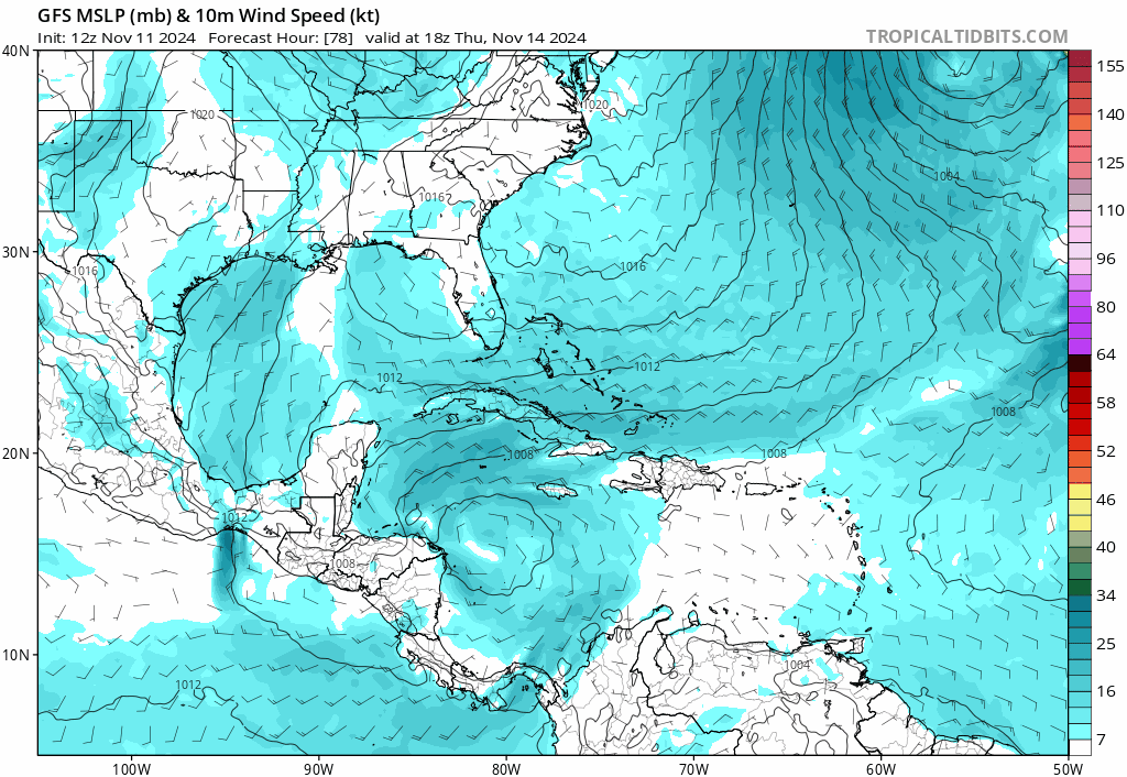
Re: Potential development over the western Caribbean Sea (0/40)
12Z GFS looks nearly identical to the 00Z Euro track:
1 likes

Re: Potential development over the western Caribbean Sea (0/40)
gatorcane wrote:12Z GFS looks nearly identical to the 00Z Euro track:
https://i.postimg.cc/Qdf0k87P/gfs-mslp-wind-watl-fh78-252.gif
Still 10 days out... hopefully the old saying that the safest spot is where the models show a storm going 10 days + out.
We just narrowly missed a big impact from Rafael in the Keys for the 4th near miss of the season. One would think by now the season would be shut down above the 23°N but this season has been thrown climatology out the window.
2 likes
-
wzrgirl1

- S2K Supporter
- Posts: 1360
- Joined: Sat Sep 04, 2004 6:44 am
- Location: Pembroke Pines, Florida
Re: Potential development over the western Caribbean Sea (0/40)
Kazmit wrote:You'd think there would be some more discussion on this one given its potential threat to FL. Guess most people are tapped out for the season, hope they aren't in for a nasty surprise.
Trust me, that discussion is not too far off. Another day or two and I surmise this joint will be jumpin'.
2 likes
-
cycloneye
- Admin
- Posts: 149682
- Age: 69
- Joined: Thu Oct 10, 2002 10:54 am
- Location: San Juan, Puerto Rico
Re: Potential development over the western Caribbean Sea (0/40)
Kazmit wrote:You'd think there would be some more discussion on this one given its potential threat to FL. Guess most people are tapped out for the season, hope they aren't in for a nasty surprise.
Things will pick up on more discussions as soon it goes up with high chance and especially, when it is tagged as invest.
3 likes
Visit the Caribbean-Central America Weather Thread where you can find at first post web cams,radars
and observations from Caribbean basin members Click Here
and observations from Caribbean basin members Click Here
-
cycloneye
- Admin
- Posts: 149682
- Age: 69
- Joined: Thu Oct 10, 2002 10:54 am
- Location: San Juan, Puerto Rico
Re: Potential development over the western Caribbean Sea (10/50)
Tropical Weather Outlook
NWS National Hurricane Center Miami FL
100 PM EST Mon Nov 11 2024
For the North Atlantic...Caribbean Sea and the Gulf of Mexico:
Central and Western Caribbean Sea:
An area of disorganized showers and thunderstorms to the south of
Hispaniola over the central Caribbean Sea is associated with a
tropical wave. This system is expected to move slowly westward
during the next few days, and environmental conditions appear
conducive for gradual development. A tropical depression could form
late this week or this weekend while meandering over the western
Caribbean Sea.
* Formation chance through 48 hours...low...10 percent.
* Formation chance through 7 days...medium...50 percent.
$$
Forecaster Reinhart

2 likes
Visit the Caribbean-Central America Weather Thread where you can find at first post web cams,radars
and observations from Caribbean basin members Click Here
and observations from Caribbean basin members Click Here
-
cycloneye
- Admin
- Posts: 149682
- Age: 69
- Joined: Thu Oct 10, 2002 10:54 am
- Location: San Juan, Puerto Rico
Re: Potential development over the western Caribbean Sea (10/50)
I am looking at the 12z European and it goes bonkers, but can't post graphic because is paid site.
0 likes
Visit the Caribbean-Central America Weather Thread where you can find at first post web cams,radars
and observations from Caribbean basin members Click Here
and observations from Caribbean basin members Click Here
-
cycloneye
- Admin
- Posts: 149682
- Age: 69
- Joined: Thu Oct 10, 2002 10:54 am
- Location: San Juan, Puerto Rico
Re: Potential development over the western Caribbean Sea (10/50)
cycloneye wrote:I am looking at the 12z European and it goes bonkers, but can't post graphic because is paid site.
This from pivotal site that can post.

0 likes
Visit the Caribbean-Central America Weather Thread where you can find at first post web cams,radars
and observations from Caribbean basin members Click Here
and observations from Caribbean basin members Click Here
-
SFLcane
- S2K Supporter
- Posts: 10281
- Age: 48
- Joined: Sat Jun 05, 2010 1:44 pm
- Location: Lake Worth Florida
Re: Potential development over the western Caribbean Sea (10/50)
cycloneye wrote:I am looking at the 12z European and it goes bonkers, but can't post graphic because is paid site.
A major hurricane that never makes it out of the carib.
1 likes
-
cycloneye
- Admin
- Posts: 149682
- Age: 69
- Joined: Thu Oct 10, 2002 10:54 am
- Location: San Juan, Puerto Rico
Re: Potential development over the western Caribbean Sea (10/50)
Run from 72 hours to 240 hours.

1 likes
Visit the Caribbean-Central America Weather Thread where you can find at first post web cams,radars
and observations from Caribbean basin members Click Here
and observations from Caribbean basin members Click Here
Re: Potential development over the western Caribbean Sea (10/50)
xironman wrote:underthwx wrote:xironman wrote:Looking at the 850 vorticity on the models it looks like this area gets drawn into the CAG to help spark genesis. Nice sharp trough. Pretty unusual to have two majors in the Atlantic Basin in Nov.
https://i.imgur.com/UoIXicJ.gif
Unfortunately not impossible tho. How long will this keep up?
I don't know, but if it was September there would be a lot more conversation on this one. I think we may see a hint at a recon flight on Wednesday today.
https://i.imgur.com/gKDiyxo.gif
Yeah, I think so too. Another one to watch for sure.
0 likes
-
toad strangler
- S2K Supporter
- Posts: 4546
- Joined: Sun Jul 28, 2013 3:09 pm
- Location: Earth
- Contact:
Re: Potential development over the western Caribbean Sea (10/50)
SFLcane wrote:cycloneye wrote:I am looking at the 12z European and it goes bonkers, but can't post graphic because is paid site.
A major hurricane that never makes it out of the carib.
Isn't that where they BELONG this time of year
4 likes
My Weather Station
https://www.wunderground.com/dashboard/pws/KFLPORTS603
https://www.wunderground.com/dashboard/pws/KFLPORTS603
-
weeniepatrol

- Category 5

- Posts: 1345
- Joined: Sat Aug 22, 2020 5:30 pm
- Location: WA State
Who is online
Users browsing this forum: No registered users and 184 guests