ATL: MILTON - Models
Moderator: S2k Moderators

Re: ATL: MILTON - Models
18z Euro, 0z ICON, 0z GFS, pretty much in the spot for landfall, probably 10 miles expand at the most between them, can't get better consensus than that relatively this far out yet.
1 likes
-
Bocadude85

- Category 5

- Posts: 2991
- Age: 39
- Joined: Mon Apr 18, 2005 2:20 pm
- Location: Honolulu,Hi
Re: ATL: MILTON - Models
CronkPSU wrote:GFS about the same landfall area again...will need someone with better resolution than i can get on pivotal to say if it is a bit further north of south...same intensity as previous models, not as sharp an east track, more ENE than the other models
South of the 18z.
0 likes
-
Blown Away

- S2K Supporter

- Posts: 10253
- Joined: Wed May 26, 2004 6:17 am
Re: ATL: MILTON - Models
Definitely a trend developing…
1 likes
Hurricane Eye Experience: David 79, Irene 99, Frances 04, Jeanne 04, Wilma 05… Hurricane Brush Experience: Andrew 92, Erin 95, Floyd 99, Matthew 16, Irma 17, Ian 22, Nicole 22…
-
SouthFLTropics

- Category 5
- Posts: 4258
- Age: 50
- Joined: Thu Aug 14, 2003 8:04 am
- Location: Port St. Lucie, Florida
Re: ATL: MILTON - Models
CMC comes in south of TB once again also. I’ve said it to many people since yesterday… I think Sarasota and down to Venice has a target on them.
Sent from my iPhone using Tapatalk
Sent from my iPhone using Tapatalk
2 likes
Fourth Generation Florida Native
Personal Storm History: David 79, Andrew 92, Erin 95, Floyd 99, Irene 99, Frances 04, Jeanne 04, Wilma 05, Matthew 16, Irma 17, Ian 22, Nicole 22, Milton 24
Personal Storm History: David 79, Andrew 92, Erin 95, Floyd 99, Irene 99, Frances 04, Jeanne 04, Wilma 05, Matthew 16, Irma 17, Ian 22, Nicole 22, Milton 24
-
Bocadude85
- Category 5
- Posts: 2991
- Age: 39
- Joined: Mon Apr 18, 2005 2:20 pm
- Location: Honolulu,Hi
Re: ATL: MILTON - Models
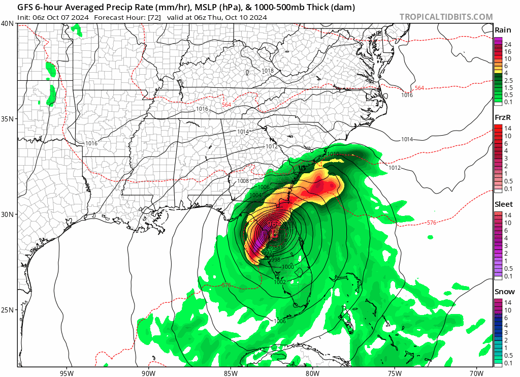
Blown Away wrote:[url]https://i.postimg.cc/3J7wP1Pf/gfs-mslp-pcpn-frzn-seus-fh54-trend.gif [/url]
Definitely a trend developing…
Yea I’d start to get nervous if I was in Port Charlotte. IMO.
Last edited by Bocadude85 on Mon Oct 07, 2024 11:02 pm, edited 1 time in total.
1 likes

Re: ATL: MILTON - Models
Bocadude85 wrote:CronkPSU wrote:GFS about the same landfall area again...will need someone with better resolution than i can get on pivotal to say if it is a bit further north of south...same intensity as previous models, not as sharp an east track, more ENE than the other models
South of the 18z.
yeah...not a lot, that angle would still be bad for tampa and just a wobble away from good or terrible news
0 likes
Just like Jon Snow..."I know nothing" except what I know, and most of what I know is gathered by the fine people of the NHC
Re: ATL: MILTON - Models
0z Canadian, no change on track or timing from 12z, Sarasota. All the models seem to be converging on the Tampa Bay to Sarasota area.

0 likes
Re: ATL: MILTON - Models
SouthFLTropics wrote:CMC comes in south of TB once again also. I’ve said it to many people since yesterday… I think Sarasota and down to Venice has a target on them.
Sent from my iPhone using Tapatalk
Looks identical to its earlier 12z run.
0 likes
Re: ATL: MILTON - Models
0z Ukmet (no graphics yet) shifts left/north to Bradenton from Venice at the 12z.
HURRICANE MILTON ANALYSED POSITION : 21.9N 90.4W
ATCF IDENTIFIER : AL142024
VERIFYING TIME POSITION STRENGTH TENDENCY
-------------- -------- -------- --------
00UTC 08.10.2024 21.9N 90.4W INTENSE
12UTC 08.10.2024 22.0N 88.9W INTENSE WEAKENING RAPIDLY
00UTC 09.10.2024 23.0N 87.3W STRONG WEAKENING SLIGHTLY
12UTC 09.10.2024 24.6N 85.9W STRONG LITTLE CHANGE
00UTC 10.10.2024 26.4N 84.6W INTENSE LITTLE CHANGE
12UTC 10.10.2024 27.4N 82.7W STRONG WEAKENING SLIGHTLY
00UTC 11.10.2024 28.6N 79.3W MODERATE WEAKENING RAPIDLY
12UTC 11.10.2024 28.8N 76.7W MODERATE WEAKENING SLIGHTLY
00UTC 12.10.2024 28.7N 74.3W MODERATE WEAKENING SLIGHTLY
12UTC 12.10.2024 29.7N 72.2W MODERATE LITTLE CHANGE
00UTC 13.10.2024 30.6N 68.4W WEAK LITTLE CHANGE
12UTC 13.10.2024 31.5N 64.0W MODERATE LITTLE CHANGE
00UTC 14.10.2024 31.2N 59.5W WEAK WEAKENING SLIGHTLY
12UTC 14.10.2024 30.7N 56.0W WEAK WEAKENING SLIGHTLY
00UTC 15.10.2024 29.5N 54.8W WEAK LITTLE CHANGE
1 likes
-
Poonwalker
- Category 1

- Posts: 270
- Joined: Tue Sep 20, 2022 11:12 am
-
ElectricStorm

- Category 5
- Posts: 5156
- Age: 25
- Joined: Tue Aug 13, 2019 11:23 pm
- Location: Norman, OK
Re: ATL: MILTON - Models
Well 0z HAFS-B can be thrown out right off the bat. Has 182kts/876mb in an hour and a half  Looks like poor initialization
3 likes
B.S Meteorology, University of Oklahoma '25
Please refer to the NHC, NWS, or SPC for official information.
Please refer to the NHC, NWS, or SPC for official information.
Re: ATL: MILTON - Models
HAFS-B is showing a more bulky system than in most previous run by a good measure by hr 27.
Also, GFS seems to be progressively showing less shear damage on approach to the bay.
Also, GFS seems to be progressively showing less shear damage on approach to the bay.
1 likes
-
FLLurker32
- Tropical Storm

- Posts: 245
- Joined: Mon Aug 29, 2016 10:31 am
Re: ATL: MILTON - Models
ElectricStorm wrote:Well 0z HAFS-B can be thrown out right off the bat. Has 182kts/876mb in an hour and a half
If we’d thrown out every model that initiated intensity wrong we’d have only had HAFS for most of this storm.
4 likes
Heather
Re: ATL: MILTON - Models
I think we would all like to throw out the HAFS-B 0z run. Not very extratropical, Clearwater landfall.
0 likes
Re: ATL: MILTON - Models
HAFS-A run has similar bad news. Not taking the hint from the GFS's slight right move. Probably because of the GFS intensity and relation to the surrounding dynamics.
0 likes
-
Poonwalker
- Category 1
- Posts: 270
- Joined: Tue Sep 20, 2022 11:12 am
Re: ATL: MILTON - Models
Hmon going into Palm Harbor area strong Cat 3, Hafs A into Madeira Beach as a cat 4.
1 likes
-
SouthFLTropics
- Category 5
- Posts: 4258
- Age: 50
- Joined: Thu Aug 14, 2003 8:04 am
- Location: Port St. Lucie, Florida
Re: ATL: MILTON - Models
HWRF is going rogue and headed to Crystal River or Cedar Key.
Sent from my iPhone using Tapatalk
Sent from my iPhone using Tapatalk
1 likes
Fourth Generation Florida Native
Personal Storm History: David 79, Andrew 92, Erin 95, Floyd 99, Irene 99, Frances 04, Jeanne 04, Wilma 05, Matthew 16, Irma 17, Ian 22, Nicole 22, Milton 24
Personal Storm History: David 79, Andrew 92, Erin 95, Floyd 99, Irene 99, Frances 04, Jeanne 04, Wilma 05, Matthew 16, Irma 17, Ian 22, Nicole 22, Milton 24
-
Poonwalker
- Category 1
- Posts: 270
- Joined: Tue Sep 20, 2022 11:12 am
-
Bocadude85
- Category 5
- Posts: 2991
- Age: 39
- Joined: Mon Apr 18, 2005 2:20 pm
- Location: Honolulu,Hi
Re: ATL: MILTON - Models
SouthFLTropics wrote:HWRF is going rogue and headed to Crystal River or Cedar Key.
Sent from my iPhone using Tapatalk
The hurricane models were to far west for Helene. I wonder if they have a west bias for Northeast moving storms.
0 likes
Re: ATL: MILTON - Models
Bocadude85 wrote:SouthFLTropics wrote:HWRF is going rogue and headed to Crystal River or Cedar Key.
Sent from my iPhone using Tapatalk
The hurricane models were to far west for Helene. I wonder if they have a west bias for Northeast moving storms.
I thought I read the HAFS-A OR B had been one of the most accurate. Anyone else read that or know if true which one?
1 likes
Who is online
Users browsing this forum: No registered users and 36 guests