ATL: MILTON - Models
Moderator: S2k Moderators
-
skillz305
- Category 1

- Posts: 312
- Joined: Sat Sep 08, 2018 11:10 am
- Location: Miami, Florida --> Vero Beach, Florida
Re: ATL: MILTON - Models
18Z NAVGEM model run in progress
1 likes
 Hurricanes: Andrew 1992 - Irene 1999 - Frances 2004 - Jeanne 2004 - Katrina 2005 - Wilma 2005 - Matthew 2016 - Irma 2017 - Ian 2022 - Nicole 2022 - Milton 2024
-
DESTRUCTION5

- Category 5

- Posts: 4430
- Age: 44
- Joined: Wed Sep 03, 2003 11:25 am
- Location: Stuart, FL
Re: ATL: MILTON - Models
ronjon wrote:DESTRUCTION5 wrote:18z Euro looks like a Sarasota to Melbourne exit..
Can someone post the graphics for 18z Euro?
Only thing working is the 850
https://www.tropicaltidbits.com/analysis/models/?model=ec-fast®ion=watl&pkg=mslp_uv850&runtime=2024100718&fh=48
0 likes
GATOR NATION IS E V E R Y W H E R E !
-
DESTRUCTION5
- Category 5
- Posts: 4430
- Age: 44
- Joined: Wed Sep 03, 2003 11:25 am
- Location: Stuart, FL
Re: ATL: MILTON - Models
ronjon wrote:DESTRUCTION5 wrote:18z Euro looks like a Sarasota to Melbourne exit..
Can someone post the graphics for 18z Euro?
Been here 20 mf yrs and still don't know how to post an image.
6 likes
GATOR NATION IS E V E R Y W H E R E !

Re: ATL: MILTON - Models
ronjon wrote:SouthFLTropics wrote:Anyone have access to the 18z hurricane models. TT is obviously getting bombed and the servers aren't handling it.
Yeah TTs servers must be overloaded. NHC was down earlier today. Can't imagine the traffic on both those sites today.
This site has some good links for models: https://www.spaghettimodels.com/
I even loaded the spaghetti models from this site and it took me to Levi's site which loaded.
1 likes
Re: ATL: MILTON - Models
HAFS-B landfall near Madiera Beach, exits into Atlantic Near Cocoa Beach (Exit point seems to be shifting right on the HAFS)

0 likes

-
jlauderdal
- S2K Supporter

- Posts: 7240
- Joined: Wed May 19, 2004 5:46 am
- Location: NE Fort Lauderdale
- Contact:
Re: ATL: MILTON - Models
Haha, 20 years for me and that doesnt include the old palm beach post board. I rarely post images. All this talk about wilma brings back bad memories, 10 days of no juice but it was cool outside.DESTRUCTION5 wrote:ronjon wrote:DESTRUCTION5 wrote:18z Euro looks like a Sarasota to Melbourne exit..
Can someone post the graphics for 18z Euro?
Been here 20 mf yrs and still don't know how to post an image.
1 likes


Re: ATL: MILTON - Models
18z HAFS-A/B correctly initialize Milton in the middle of an EWRC and show its pressure rising into the upper 930s by tomorrow, with a secondary peak tomorrow afternoon in the 910s (A) or 900s (B). Starts feeling the effects of shear by Wednesday morning.
2 likes
Irene '11 Sandy '12 Hermine '16 5/15/2018 Derecho Fay '20 Isaias '20 Elsa '21 Henri '21 Ida '21
I am only a meteorology enthusiast who knows a decent amount about tropical cyclones. Look to the professional mets, the NHC, or your local weather office for the best information.
I am only a meteorology enthusiast who knows a decent amount about tropical cyclones. Look to the professional mets, the NHC, or your local weather office for the best information.
-
Blown Away

- S2K Supporter
- Posts: 10253
- Joined: Wed May 26, 2004 6:17 am
Re: ATL: MILTON - Models
I think we will slowly see the track closer to Cape Coral and a ENE track across FL… These near 90 degree turns to the E after @Tampa do not look right when a tropical system is riding along a trough… JMHO
1 likes
Hurricane Eye Experience: David 79, Irene 99, Frances 04, Jeanne 04, Wilma 05… Hurricane Brush Experience: Andrew 92, Erin 95, Floyd 99, Matthew 16, Irma 17, Ian 22, Nicole 22…
Re: ATL: MILTON - Models
0z Earlies, very slight tick left/north. All on here are north of Englewood now, and south of New Port Richey. (Even the UKMet) So the cluster is tightening. Don't really see any good reason to doubt the NHC track.

Last edited by BobHarlem on Mon Oct 07, 2024 8:18 pm, edited 3 times in total.
1 likes
-
Blown Away
- S2K Supporter
- Posts: 10253
- Joined: Wed May 26, 2004 6:17 am
Re: ATL: MILTON - Models
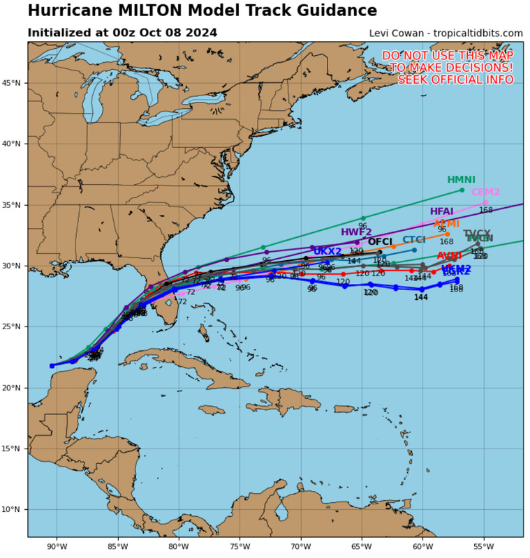
00z… Models keep shifting/flattening S after crossing FL… This may start affecting the angle of approach to the FL W Coast…
5 likes
Hurricane Eye Experience: David 79, Irene 99, Frances 04, Jeanne 04, Wilma 05… Hurricane Brush Experience: Andrew 92, Erin 95, Floyd 99, Matthew 16, Irma 17, Ian 22, Nicole 22…

Re: ATL: MILTON - Models
BobHarlem wrote:18z HWRF Tarpon Springs, exit just south of New Smyrna Beach
https://i.imgur.com/NBBy7eO.gif
HWRF is a full 12 hours later on landfall than the HAFS - Thursday afternoon.
0 likes
-
Tekken_Guy
- Tropical Storm

- Posts: 150
- Joined: Fri Sep 01, 2017 8:08 pm
Re: ATL: MILTON - Models
Blown Away wrote:[url]https://i.postimg.cc/W3rm22XG/IMG-0600.jpg [/url]
00z… Models keep shifting/flattening S after crossing FL… This may start affecting the angle of approach to the FL W Coast…
It looks like the landfall point is moving towards Bradenton according to those models. That would mitigate the worst-case surge scenario for the bay reltaive to a landfall on Pinellas or Pasco.
2 likes
-
Weathertracker96
- Tropical Storm
- Posts: 150
- Joined: Mon Oct 16, 2023 3:41 pm
Re: ATL: MILTON - Models
Blown Away wrote:[url]https://i.postimg.cc/W3rm22XG/IMG-0600.jpg [/url]
00z… Models keep shifting/flattening S after crossing FL… This may start affecting the angle of approach to the FL W Coast…
I agree. Interested to see how models do overnight. I won't be shocked if it pulls a last minute charley.
1 likes

Re: ATL: MILTON - Models
Stormgodess wrote:
Is it skirting the coast moving North in that clip? Or is that two different models?
Please explain like I'm a 5 yr old
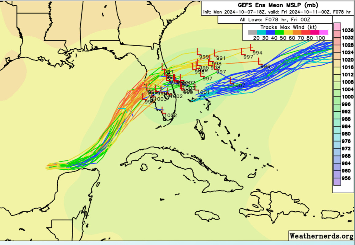
That GIF is NOT showing a path of the storm. It it showing WHERE the storm is forecast to be on two consecutive runs of the GFS model. SO the 18z (Evening run) is showing a landfall a few miles south of the 12z (noon) run of that model.
Last edited by mitchell on Mon Oct 07, 2024 8:16 pm, edited 1 time in total.
2 likes
-
Blown Away
- S2K Supporter
- Posts: 10253
- Joined: Wed May 26, 2004 6:17 am
Re: ATL: MILTON - Models
18z GEFS… Large cluster S of Tampa now… Gotta think some S track shifts are coming…
2 likes
Hurricane Eye Experience: David 79, Irene 99, Frances 04, Jeanne 04, Wilma 05… Hurricane Brush Experience: Andrew 92, Erin 95, Floyd 99, Matthew 16, Irma 17, Ian 22, Nicole 22…
-
DESTRUCTION5
- Category 5
- Posts: 4430
- Age: 44
- Joined: Wed Sep 03, 2003 11:25 am
- Location: Stuart, FL

Re: ATL: MILTON - Models
Blown Away wrote:I think we will slowly see the track closer to Cape Coral and a ENE track across FL… These near 90 degree turns to the E after @Tampa do not look right when a tropical system is riding along a trough… JMHO
But it’s October. Things are different.
2 likes
Who is online
Users browsing this forum: No registered users and 46 guests