
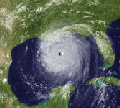
Steve wrote:NAM 12km is useless this run. It hits around 977mb but as it's going on a trajectory that would take it slightly north of Tampa it jumps right at landfall and goes in south of where you think it would. Only thing I can see that would cause that is the east Canadian trough 's western periphery is exiting the same time Milton is making landfall. Could happen, but I'm disregarding the tropical aspects of this run.
NAM 3km is a trip. It only goes out to 60 hours, but in the last data point it shows 3 lows pop out to the north. It's having a brain freeze or something. However IR simulation is showing degrading heading close to landfall from what it was as it starts coming into range which is encouraging (but it's the NAM)
"Lows"
https://www.tropicaltidbits.com/analysi ... 0712&fh=60
IR Sim
https://www.tropicaltidbits.com/analysi ... 0712&fh=60
FV3 Hi-res comes in at about 967 21z Wednesday +/- the bay/Pinellas
https://www.tropicaltidbits.com/analysi ... 0712&fh=57
ICON is running now. Unfortunately it's initialized with 981mb when it's like 50mb deeper. So track might be good but intensity probably not.
The 3k has the wrong physics for tropical systems, is it made mid-latitude extratropical systems, and now actually does a decent job of it


