
ATL: MILTON - Models
Moderator: S2k Moderators
Re: ATL: MILTON - Models
So south shift is coming. I fully expected this, it's going to be hard to ever sell people in Tampa about a hurricane after this one heh
2 likes
-
tolakram
- Admin

- Posts: 20186
- Age: 62
- Joined: Sun Aug 27, 2006 8:23 pm
- Location: Florence, KY (name is Mark)
Re: ATL: MILTON - Models
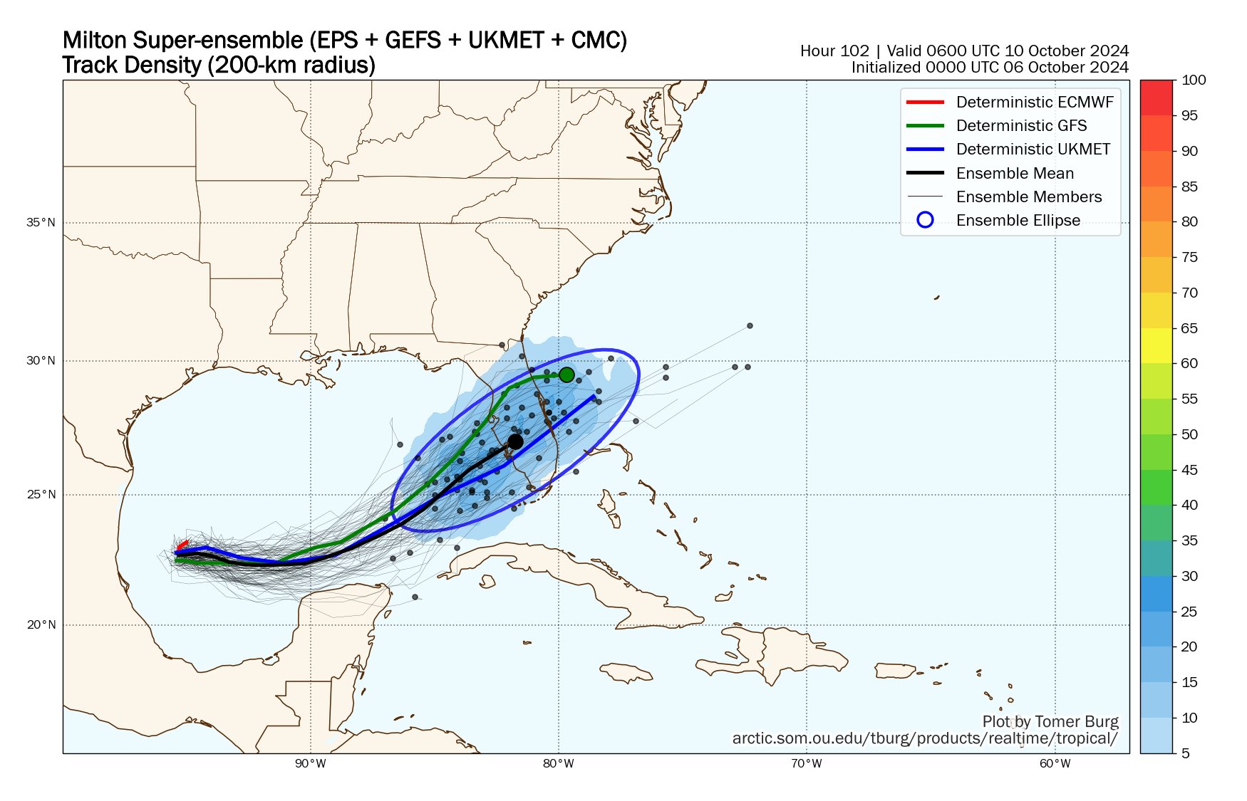
6Z hurricane models


1 likes
M a r k
- - - - -
Join us in chat: Storm2K Chatroom Invite. Android and IOS apps also available.
The posts in this forum are NOT official forecasts and should not be used as such. Posts are NOT endorsed by any professional institution or STORM2K.org. For official information and forecasts, please refer to NHC and NWS products.
Re: ATL: MILTON - Models
LandoWill wrote:So south shift is coming. I fully expected this, it's going to be hard to ever sell people in Tampa about a hurricane after this one heh
https://pbs.twimg.com/media/GZNX8BlWsAA60Lc?format=jpg&name=large
South shift still leaves Tampa bay very much in the cone
5 likes
-
tolakram
- Admin
- Posts: 20186
- Age: 62
- Joined: Sun Aug 27, 2006 8:23 pm
- Location: Florence, KY (name is Mark)
Re: ATL: MILTON - Models
LandoWill wrote:So south shift is coming. I fully expected this, it's going to be hard to ever sell people in Tampa about a hurricane after this one heh
https://pbs.twimg.com/media/GZNX8BlWsAA60Lc?format=jpg&name=large
I'll warn you in thread, if you can't control the silly angry outbursts you will be taking a break.
9 likes
M a r k
- - - - -
Join us in chat: Storm2K Chatroom Invite. Android and IOS apps also available.
The posts in this forum are NOT official forecasts and should not be used as such. Posts are NOT endorsed by any professional institution or STORM2K.org. For official information and forecasts, please refer to NHC and NWS products.
- - - - -
Join us in chat: Storm2K Chatroom Invite. Android and IOS apps also available.
The posts in this forum are NOT official forecasts and should not be used as such. Posts are NOT endorsed by any professional institution or STORM2K.org. For official information and forecasts, please refer to NHC and NWS products.


-
johngaltfla

- Category 5

- Posts: 2073
- Joined: Sun Jul 10, 2005 9:17 pm
- Location: Sarasota County, FL
- Contact:
Re: ATL: MILTON - Models
I'll be very curious to see the 1800 Z runs once more recon data is fed into the models. I haven't noticed, is there a high altitude mission schedule for today and tomorrow?
All of that will give us a clue as to the ENE/NE turn.
EDIT: Never mind, just found the NOAA flights up to 45,000 in the recon thread, missed it earlier. Can't believe there isn't one today however.
All of that will give us a clue as to the ENE/NE turn.
EDIT: Never mind, just found the NOAA flights up to 45,000 in the recon thread, missed it earlier. Can't believe there isn't one today however.
Last edited by johngaltfla on Sun Oct 06, 2024 9:11 am, edited 1 time in total.
0 likes
-
WeatherBoy2000
- Category 1

- Posts: 463
- Joined: Mon Apr 10, 2023 9:29 am
Re: ATL: MILTON - Models
LandoWill wrote:So south shift is coming. I fully expected this, it's going to be hard to ever sell people in Tampa about a hurricane after this one heh
https://pbs.twimg.com/media/GZNX8BlWsAA60Lc?format=jpg&name=large
Although the southward shift is encouraging for those in Tampa there could still easily be a shift back north. Models are still clearly trying to figure this thing out. Tampa is hardly out of the woods yet by any stretch of the imagination.
9 likes
-
eastcoastFL

- Category 5
- Posts: 3996
- Age: 44
- Joined: Thu Apr 12, 2007 12:29 pm
- Location: Palm City, FL
Re: ATL: MILTON - Models
johngaltfla wrote:I'll be very curious to see the 1800 Z runs once more recon data is fed into the models. I haven't noticed, is there a high altitude mission schedule for today and tomorrow?
All of that will give us a clue as to the ENE/NE turn.
EDIT: Never mind, just found the NOAA flights up to 45,000 in the recon thread, missed it earlier. Can't believe there isn't one today however.
Looks like tomorrow
SUSPECT AREA (SOUTHWEST GULF OF MEXICO).....ADDED
FLIGHT ONE - NOAA 43
A. 06/1200Z
B. NOAA3 01HHA TDR
C. 06/0800Z
D. 22.0N 94.0W
E. 06/1000Z TO 06/1400Z
F. SFC TO 10,000 FT
G. TAIL DOPPLER RADAR
H. WRA ACTIVATION
2. OUTLOOK FOR SUCCEEDING DAY:
A. POSSIBLE LOW-LEVEL INVEST MISSION IN THE SOUTHWEST GULF OF
MEXICO NEAR 22.5N 92.5W FOR 06/1800Z. (NO CHANGES)
B. POSSIBLE NOAA P-3 TAIL DOPPLER RADAR MISSIONS INTO THE GULF
OF MEXICO SUSPECT AREA FOR 07/0000Z AND 07/1200Z, DEPARTING
KLAL AT 06/2000Z AND 07/0800Z, RESPECTIVELY. (CHANGED)
1 likes
Personal Forecast Disclaimer:
The posts in this forum are NOT official forecast and should not be used as such. They are just the opinion of the poster and may or may not be backed by sound meteorological data. They are NOT endorsed by any professional institution or storm2k.org. For official information, please refer to the NHC and NWS products.
The posts in this forum are NOT official forecast and should not be used as such. They are just the opinion of the poster and may or may not be backed by sound meteorological data. They are NOT endorsed by any professional institution or storm2k.org. For official information, please refer to the NHC and NWS products.
-
tolakram
- Admin
- Posts: 20186
- Age: 62
- Joined: Sun Aug 27, 2006 8:23 pm
- Location: Florence, KY (name is Mark)
Re: ATL: MILTON - Models
Globals


2 likes
M a r k
- - - - -
Join us in chat: Storm2K Chatroom Invite. Android and IOS apps also available.
The posts in this forum are NOT official forecasts and should not be used as such. Posts are NOT endorsed by any professional institution or STORM2K.org. For official information and forecasts, please refer to NHC and NWS products.
- - - - -
Join us in chat: Storm2K Chatroom Invite. Android and IOS apps also available.
The posts in this forum are NOT official forecasts and should not be used as such. Posts are NOT endorsed by any professional institution or STORM2K.org. For official information and forecasts, please refer to NHC and NWS products.
-
MEANINGLESS_NUMBERS
- Category 2

- Posts: 503
- Joined: Mon Nov 02, 2020 1:43 pm
Re: ATL: MILTON - Models
The only way to read these models is “significant hurricane near Tampa landfalling perpendicular to the coast.” That is a nightmare scenario for storm surge. Anyone who takes comfort in a 20 mile shift in landfall is fooling themselves, the models just don’t have that sort of accuracy at this range.
6 likes
Emily '87, Felix '95, Gert '99, Fabian '03, Humberto '19, Paulette '20, Teddy '20, Fiona '22, Lee '23, Ernesto '24, Humberto/Imelda '25
-
StPeteMike

- Category 2
- Posts: 657
- Joined: Thu Jun 07, 2018 11:26 pm
Re: ATL: MILTON - Models
MEANINGLESS_NUMBERS wrote:The only way to read these models is “significant hurricane near Tampa.” Anyone who takes comfort in a 20 mile shift is landfall is fooling themselves, the models just don’t have that sort of accuracy at this range.
Exactly! The models could easily move back up to the track north of Tampa Bay come with the 18z or 0z. If I remember correctly, the models for Helene didn’t really hone in to the Big Bend area until 2 days out.
The models on late Monday will be more reliable, to me at least.
Just know, the models have kept the nasty side to the north and south, so a south track just south of Tampa Bay will still bring heavy rains, strong winds, and the higher risk of tornados.
0 likes
The above post is not official and should not be used as such. It is the opinion of the poster and may or may not be backed by sound meteorological data. It is not endorsed by any professional institution or storm2k.org. For official information, please refer to the NHC and NWS products.
-
tolakram
- Admin
- Posts: 20186
- Age: 62
- Joined: Sun Aug 27, 2006 8:23 pm
- Location: Florence, KY (name is Mark)
Re: ATL: MILTON - Models
Trust in the ICON just got real, will it be correct again with sniffing out the east/south shift early?
Do you trust the Euro jump north and stop solution?

Or the ICON; stay well south but also weaker solution?

Do you trust the Euro jump north and stop solution?
Or the ICON; stay well south but also weaker solution?
0 likes
M a r k
- - - - -
Join us in chat: Storm2K Chatroom Invite. Android and IOS apps also available.
The posts in this forum are NOT official forecasts and should not be used as such. Posts are NOT endorsed by any professional institution or STORM2K.org. For official information and forecasts, please refer to NHC and NWS products.
- - - - -
Join us in chat: Storm2K Chatroom Invite. Android and IOS apps also available.
The posts in this forum are NOT official forecasts and should not be used as such. Posts are NOT endorsed by any professional institution or STORM2K.org. For official information and forecasts, please refer to NHC and NWS products.


Re: ATL: MILTON - Models
tolakram wrote:Trust in the ICON just got real, will it be correct again with sniffing out the east/south shift early?
Do you trust the Euro jump north and stop solution?
https://i.imgur.com/FpLYKKi.gif
Or the ICON; stay well south but also weaker solution?
https://i.imgur.com/mLirR6a.gif
You spoke too soon before its 12z run.
ICON has been fairly inconsistent with Milton so far, IMO.
4 likes

Re: ATL: MILTON - Models
Let the windshield wiping begin. This is why I'm reluctant to call out shifts North/South before seeing a trend of more than one model run.
1 likes

Re: ATL: MILTON - Models
I didn’t trust the 06z ICON anyway. Far too weak.
0 likes
Igor 2010, Sandy 2012, Fay 2014, Gonzalo 2014, Joaquin 2015, Nicole 2016, Humberto 2019, Imelda 2025
I am only a tropical weather enthusiast. My predictions are not official and may or may not be backed by sound meteorological data. For official information, please refer to the NHC and NWS products.
I am only a tropical weather enthusiast. My predictions are not official and may or may not be backed by sound meteorological data. For official information, please refer to the NHC and NWS products.
-
islandgirl45
- Tropical Low

- Posts: 22
- Joined: Tue Oct 20, 2009 10:51 pm
-
tolakram
- Admin
- Posts: 20186
- Age: 62
- Joined: Sun Aug 27, 2006 8:23 pm
- Location: Florence, KY (name is Mark)
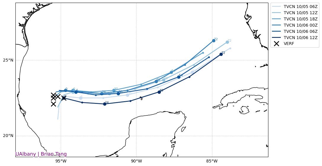
Re: ATL: MILTON - Models
Still running

0 likes
M a r k
- - - - -
Join us in chat: Storm2K Chatroom Invite. Android and IOS apps also available.
The posts in this forum are NOT official forecasts and should not be used as such. Posts are NOT endorsed by any professional institution or STORM2K.org. For official information and forecasts, please refer to NHC and NWS products.
- - - - -
Join us in chat: Storm2K Chatroom Invite. Android and IOS apps also available.
The posts in this forum are NOT official forecasts and should not be used as such. Posts are NOT endorsed by any professional institution or STORM2K.org. For official information and forecasts, please refer to NHC and NWS products.
-
tolakram
- Admin
- Posts: 20186
- Age: 62
- Joined: Sun Aug 27, 2006 8:23 pm
- Location: Florence, KY (name is Mark)
Re: ATL: MILTON - Models
islandgirl45 wrote:
Where does this model exit the east coast?

0 likes
M a r k
- - - - -
Join us in chat: Storm2K Chatroom Invite. Android and IOS apps also available.
The posts in this forum are NOT official forecasts and should not be used as such. Posts are NOT endorsed by any professional institution or STORM2K.org. For official information and forecasts, please refer to NHC and NWS products.
- - - - -
Join us in chat: Storm2K Chatroom Invite. Android and IOS apps also available.
The posts in this forum are NOT official forecasts and should not be used as such. Posts are NOT endorsed by any professional institution or STORM2K.org. For official information and forecasts, please refer to NHC and NWS products.
Who is online
Users browsing this forum: No registered users and 34 guests