There is no doubt tb is in the bullseye, I dont see much wiggle room either north or south, north is worse in terms of surge. This looks very different than Helene in terms of people affected by a big surge.ConvergenceZone wrote:Blown Away wrote:[url]https://i.postimg.cc/TPSSqV5p/IMG-0520.jpg [/url]
12z HWRF shifted S from 06z… Wow directly into TB…
I realize it's unlikely to come to pass, but between the location and strength, that truly would be a doomsday scenario.
ATL: MILTON - Models
Moderator: S2k Moderators
-
jlauderdal
- S2K Supporter

- Posts: 7240
- Joined: Wed May 19, 2004 5:46 am
- Location: NE Fort Lauderdale
- Contact:
Re: ATL: MILTON - Models
3 likes

Re: ATL: MILTON - Models
jhpigott wrote:
I know we've talked about the stronger modeled storms are further north and weaker south, but it also looks like speed of the system (per the Euro ensembles) will play a role in N vs. S. impacts. Faster looks north. Slower looks more south.
I also noticed the GFS and ICON show slightly south turn after it passed Florida, after a ENE to NE jog before hitting the peninsula.
As always the timing of these turn is critical, if they even happen.
Despite the tightly clustered guidance, I do think there might be some higher than expected errors as these strong east moving storms in the GoM are rare
2 likes

Re: ATL: MILTON - Models
AtlanticWind wrote:NDG wrote:Close up look at latest 18z early tropical models. Expect a shift north over and narrowing of the cone by the next NHC advisory.
My heart aches for Tampa Bay.
https://i.imgur.com/GrRXWe2.jpeg
The cone size is not affected by models if I’m not mistaken
It is based on average error
They take average error more into consideration once the models are in better agreement like they have become this afternoon, so I guarantee you the cone of uncertainty will be narrower than just 6 hours ago.
2 likes
-
toad strangler

- S2K Supporter
- Posts: 4546
- Joined: Sun Jul 28, 2013 3:09 pm
- Location: Earth
- Contact:
Re: ATL: MILTON - Models
chaser1 wrote:BobHarlem wrote:18z earlies, slight shift left (north), lot's of I-4 riders here.
https://i.imgur.com/BIJ92Sv.png
I'm beginning to wonder about the prospect for this continual northward shift to continue all the way to Cedar Key.
There is a ton of real estate ahead of Milton. I would be very surprised if there wasn’t a period of shifts to the south. Windshield wipers move both ways!

1 likes
My Weather Station
https://www.wunderground.com/dashboard/pws/KFLPORTS603
https://www.wunderground.com/dashboard/pws/KFLPORTS603
-
gatorcane

- S2K Supporter
- Posts: 23708
- Age: 48
- Joined: Sun Mar 13, 2005 3:54 pm
- Location: Boca Raton, FL
Re: ATL: MILTON - Models
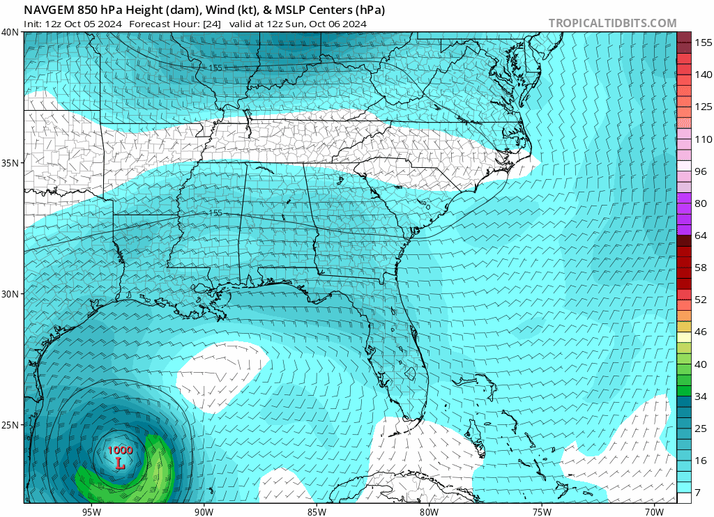
12Z NAVGEM is definitely stronger than previous recent runs. 850MB (not surface) chart below, it is modelling a storm that grows significantly in size through the forecast period:
1 likes
-
Blown Away

- S2K Supporter
- Posts: 10253
- Joined: Wed May 26, 2004 6:17 am
Re: ATL: MILTON - Models
Systems moving OTS on a sharp ENE track instead of the traditional NE just off the Atlantic Seaboard tend error to the east of the track early on… I could see that little hump in the models where Milton moves over FL flatten a bit… JMHO
4 likes
Hurricane Eye Experience: David 79, Irene 99, Frances 04, Jeanne 04, Wilma 05… Hurricane Brush Experience: Andrew 92, Erin 95, Floyd 99, Matthew 16, Irma 17, Ian 22, Nicole 22…
Re: ATL: MILTON - Models
toad strangler wrote:AtlanticWind wrote:NDG wrote:Close up look at latest 18z early tropical models. Expect a shift north over and narrowing of the cone by the next NHC advisory.
My heart aches for Tampa Bay.
https://i.imgur.com/GrRXWe2.jpeg
The cone size is not affected by models if I’m not mistaken
It is based on average error
True story. The cone has nothing to do with the confidence in forecast. It’s made up with circles of average margin of error over periods of time.
At the 11 AM discussion they mentioned this: "Users
are reminded to not focus on the exact forecast track or timing at
the longer range as the average NHC 4-day track error is about 150
miles."
The current Cone at day 4 is nearly 400 miles wide, that's way more than the average error.
2 likes
-
Canelaw99

- S2K Supporter
- Posts: 2128
- Age: 49
- Joined: Tue Aug 31, 2004 8:27 am
- Location: Homestead, FL
Re: ATL: MILTON - Models
For those that want to read up on how the cone is created. Information directly from the NHC: https://www.nhc.noaa.gov/aboutcone.shtml
6 likes
-
Spacecoast

- Category 2

- Posts: 773
- Joined: Thu Aug 31, 2017 2:03 pm
Re: ATL: MILTON - Models
[quote="NDG"
The current Cone at day 4 is nearly 400 miles wide, that's way more than the average error.[/quote]
I believe they are referring to +/- 150 miles, or ~300 miles wide.
The current Cone at day 4 is nearly 400 miles wide, that's way more than the average error.[/quote]
I believe they are referring to +/- 150 miles, or ~300 miles wide.
2 likes
-
toad strangler
- S2K Supporter
- Posts: 4546
- Joined: Sun Jul 28, 2013 3:09 pm
- Location: Earth
- Contact:
Re: ATL: MILTON - Models
NDG wrote:toad strangler wrote:AtlanticWind wrote:
The cone size is not affected by models if I’m not mistaken
It is based on average error
True story. The cone has nothing to do with the confidence in forecast. It’s made up with circles of average margin of error over periods of time.
At the 11 AM discussion they mentioned this: "Users
are reminded to not focus on the exact forecast track or timing at
the longer range as the average NHC 4-day track error is about 150
miles."
The current Cone at day 4 is nearly 400 miles wide, that's way more than the average error.
OK, Well, that would go Against everything I’ve understood about the cone previously. I’ve been wrong before
1 likes
My Weather Station
https://www.wunderground.com/dashboard/pws/KFLPORTS603
https://www.wunderground.com/dashboard/pws/KFLPORTS603
-
cheezyWXguy

- Category 5

- Posts: 6282
- Joined: Mon Feb 13, 2006 12:29 am
- Location: Dallas, TX
Re: ATL: MILTON - Models
toad strangler wrote:NDG wrote:toad strangler wrote:
True story. The cone has nothing to do with the confidence in forecast. It’s made up with circles of average margin of error over periods of time.
At the 11 AM discussion they mentioned this: "Users
are reminded to not focus on the exact forecast track or timing at
the longer range as the average NHC 4-day track error is about 150
miles."
The current Cone at day 4 is nearly 400 miles wide, that's way more than the average error.
OK, Well, that would go Against everything I’ve understood about the cone previously. I’ve been wrong before
No you’re right. This has been hashed out a number of times before, it’s based on average historical track error, not uncertainty in the moment. Rough eyeballing the cone and measuring the edge points at day 4 using the distance feature on RadarScope, I get a rough estimate of about 330 miles. I don’t think the forecaster is being precise with the 150 mile estimate, as there’s not really a reason to be, so I think it checks out.
Edit: canelaw’s link above shows track error margin at day 4 is 151 nautical miles, or about 174 miles. So a 350 mile wide cone at day 4 is to be expected.
Last edited by cheezyWXguy on Sat Oct 05, 2024 3:45 pm, edited 1 time in total.
6 likes
Re: ATL: MILTON - Models
Spacecoast wrote:[quote="NDG"
The current Cone at day 4 is nearly 400 miles wide, that's way more than the average error.
I believe they are referring to +/- 150 miles, or ~300 miles wide.[/quote]
So yes, 100 miles less wide than the 11 AM cone at day 4.
1 likes
-
jlauderdal
- S2K Supporter
- Posts: 7240
- Joined: Wed May 19, 2004 5:46 am
- Location: NE Fort Lauderdale
- Contact:
Re: ATL: MILTON - Models
Its all stats, there is no massaging it from the nhc unlike a development area. Incredible we are getting another big surge event in a similiar area. Hopefully we can find some shear.cheezyWXguy wrote:toad strangler wrote:NDG wrote:
At the 11 AM discussion they mentioned this: "Users
are reminded to not focus on the exact forecast track or timing at
the longer range as the average NHC 4-day track error is about 150
miles."
The current Cone at day 4 is nearly 400 miles wide, that's way more than the average error.
OK, Well, that would go Against everything I’ve understood about the cone previously. I’ve been wrong before
No you’re right. This has been hashed out a number of times before, it’s based on average historical track error, not uncertainty in the moment. Rough eyeballing the cone and measuring the edge points at day 4 using the distance feature on RadarScope, I get a rough estimate of about 330 miles. I don’t think the forecaster is being precise with the 150 mile estimate, as there’s not really a reason to be, so I think it checks out.
0 likes
-
gatorcane
- S2K Supporter
- Posts: 23708
- Age: 48
- Joined: Sun Mar 13, 2005 3:54 pm
- Location: Boca Raton, FL
Re: ATL: MILTON - Models
Indeed looks like NHC going with a major hurricane and mentioned it may have to increase the intensity in future advisories.
3 likes
-
jasons2k

- Storm2k Executive

- Posts: 8290
- Age: 52
- Joined: Wed Jul 06, 2005 12:32 pm
- Location: The Woodlands, TX
ATL: MILTON - Models
All — this is the model thread. Save the discussions about the cone, the NHC, speculation about advisories, etc., for the discussion thread please. Thanks.
3 likes

Re: ATL: MILTON - Models
Salute!
Well, praying again so soon, but this one looks like a Sarasota, Ft Meyers, and south of Tampa Bay for a surge effect.
Lottsa people east of landfall predictions so much more human impact than Hell-leen. Here's hoping strength numbers are too high.
Gums sends...
Well, praying again so soon, but this one looks like a Sarasota, Ft Meyers, and south of Tampa Bay for a surge effect.
Lottsa people east of landfall predictions so much more human impact than Hell-leen. Here's hoping strength numbers are too high.
Gums sends...
2 likes
-
TampaWxLurker
- Tropical Storm

- Posts: 196
- Joined: Thu Aug 01, 2024 8:20 am
Re: ATL: MILTON - Models
18z Icon coming in slower and a little further south so far through 84 hours.
0 likes
Re: ATL: MILTON - Models
18z icon takes a bit longer for landfall near Venice/Sarasota, but track is nearly identical to 12z, 966mb in the frame prior to this one.

2 likes
Re: ATL: MILTON - Models
TampaWxLurker wrote:18z Icon coming in slower and a little further south so far through 84 hours.
ICON might have sniffed this out early but it has been very inconsistent from run to run on track and timing.
2 likes
-
TampaWxLurker
- Tropical Storm
- Posts: 196
- Joined: Thu Aug 01, 2024 8:20 am
Re: ATL: MILTON - Models
Interesting thing with that ICON run. Has it slowing down just before landfall, not full onshore until very early Thursday, then taking an almost due East track and exiting near Ft. Pierce/Vero Beach.
0 likes
Who is online
Users browsing this forum: No registered users and 41 guests