ATL: MILTON - Post-Tropical - Discussion

Moderator: S2k Moderators

Message
Author
User avatar
Jr0d
S2K Supporter
S2K Supporter
Posts: 1409
Joined: Tue Aug 27, 2019 10:52 am
Location: Cayo Hueso

Re: ATL: FOURTEEN - Tropical Depression - Discussion

#201 Postby Jr0d » Sat Oct 05, 2024 11:40 am

caneman wrote:
Zonacane wrote:What is the expected storm surge for a category 4 in Tampa?


I would think quite a bit worse than Helene as it would be direct and coming from the worst possible angle for surge

For Tampa's sake lets hope this storm goes south so they would get the 'blow-out' instead of the surge.

Unfortunately that would then put the areas hit by Ian in the crosshairs again with areas like Fort Myers likely to see extreme surge.

The extra time and distance this will have over water could cause locally higher surge than Helene near the eyewall(assuming it gets that strong), hopefully the smaller size will prevent the widespread surge we saw with Helene.

The next forecasts critical, some of the further south ones are even stronger meaning the Florida Keys could see hurricane conditions perhaps major hurricane conditions. The evacuation of the area is extremely difficult with only one road out....
6 likes   

Michele B
S2K Supporter
S2K Supporter
Posts: 1114
Joined: Thu Aug 25, 2016 8:08 am
Location: SWFL

Re: ATL: FOURTEEN - Tropical Depression - Discussion

#202 Postby Michele B » Sat Oct 05, 2024 11:40 am

GCANE wrote:That whole front idea has pretty much dissipated on GFS.
A very minor UL trof is forecast to develop on approach to landfall.
Looks like it will be a minor disruption,


If the trough dissipates, or moves north, will that steer the storm more northerly?? That's surely not something the folks at Cedar Key or more north do not need.
0 likes   
Cleo - 1964, Betsy - 1965, David - 1979, Andrew - 1992, Charlie (Francis, Ivan, Jeanne) - 2004, Irma - 2017, Ian - 2022

zzzh
Category 3
Category 3
Posts: 834
Joined: Thu Sep 02, 2021 1:13 pm

Re: ATL: FOURTEEN - Tropical Depression - Discussion

#203 Postby zzzh » Sat Oct 05, 2024 11:41 am

 https://x.com/WxPatel/status/1842604512579817802


ASCAT confirms well defined center and TS wind. We will have Milton by 18z.
6 likes   

BIFF_THE_UNRULY
Tropical Storm
Tropical Storm
Posts: 143
Joined: Fri Jun 28, 2024 2:12 pm

Re: ATL: FOURTEEN - Tropical Depression - Discussion

#204 Postby BIFF_THE_UNRULY » Sat Oct 05, 2024 11:45 am

Hugo1989 wrote:I can’t imagine this eye of a cat 3 moving across the Tampa bay! Water surge, winds and rain would catastrophic. There are too many houses (most of them mansions) around the bay. All the damages causes will be historic. Nobody is ready to watch this scenario!


Well...I can sum it up for you

Its over. The city population would halve over a week.

I live here. It floods awful already with just a rainstorm. But the complacency and the amount of building up here has really exacerbated everything, the draining system is beyond destroyed as it is because of all the growth since 2020

If we get a Category 4 or 5. This city is toast. All these transplants wont stick around, they will go back to wherever they came and the city will be an economic black hole like new orleans was after Katrina. Not to mention Downtown, the Airport and 30% of the rest of the city and suburbs would be completely under storm surge. Pinellas would be toast aswell
Last edited by BIFF_THE_UNRULY on Sat Oct 05, 2024 11:48 am, edited 2 times in total.
5 likes   

Poonwalker
Category 1
Category 1
Posts: 270
Joined: Tue Sep 20, 2022 11:12 am

Re: ATL: FOURTEEN - Tropical Depression - Discussion

#205 Postby Poonwalker » Sat Oct 05, 2024 11:45 am

Can’t believe Iam back on here seeing another possible major hitting Florida. This has to be the worst season ever. If it stays south of Tampa it’s still going to destroy a populated place like Ft Myers, Sarasota, and possibly even Naples. North will be horrible for Tampa and Pinellas which is a double blow. This is just nuts.
Last edited by Poonwalker on Sat Oct 05, 2024 11:46 am, edited 1 time in total.
4 likes   

User avatar
Zonacane
Category 1
Category 1
Posts: 361
Joined: Tue Aug 03, 2021 2:23 pm

Re: ATL: FOURTEEN - Tropical Depression - Discussion

#206 Postby Zonacane » Sat Oct 05, 2024 11:46 am

aspen wrote:
GCANE wrote:Looks like it will pick up a high TPW feed from the EPAC while in the BOC.
Once it gets in the E GOM, it'll pick up a high CAPE feed from the W Carb.
Will also be over the Lopp Current which has recharged from Helene.
Only limiting factor as a see for now from becoming a top-scale cane is that it appears that it will not be under an anti-cyclone.

Its UL setup isn’t great. It’ll be tracking on the south end of some extremely strong (>50 kt) UL flow, which might help with some ventilation, but could very easily shear the system to death.

How much this helps or harms Milton will probably depend on the exact latitude it tracks. HWRF shows shear kicking in as Milton approaches Florida and gains latitude.

EDIT: not 50+ kt, I was looking at the wrong graphic on Tropical Tidbits. Still fairly strong near-horizontal flow, doesn’t seem like a good setup for ventilation regardless.

We’ve seen this a lot, it’s the same direction as storm movement and doesn’t qualify as shear.
0 likes   

User avatar
Xyls
Tropical Storm
Tropical Storm
Posts: 162
Joined: Thu Sep 07, 2023 3:48 pm
Location: New Brunswick, Canada

Re: ATL: FOURTEEN - Tropical Depression - Discussion

#207 Postby Xyls » Sat Oct 05, 2024 11:49 am

BIFF_THE_UNRULY wrote:
Hugo1989 wrote:I can’t imagine this eye of a cat 3 moving across the Tampa bay! Water surge, winds and rain would catastrophic. There are too many houses (most of them mansions) around the bay. All the damages causes will be historic. Nobody is ready to watch this scenario!


Well...I can sum it up for you

Its over. The city population would halve over a week.

I live here. It floods awful already with just a rainstorm. But the complacency and the amount of building up here has really exacerbated everything, the draining system is beyond destroyed as it is because of all the growth since 2020

If we get a Category 4 or 5. This city is toast. All these transplants wont stick around, they will go back to wherever they came and the city will be an economic black hole like new orleans was after Katrina. Not to mention Downtown, the Airport and 30% of the rest of the city and suburbs would be completely under storm surge.


Wouldn't just be a local economic black hole. I would question whether the Florida insurance market would survive such a strike and that would have major implications on the housing market/economy of Florida and in turn the United States as a whole.
4 likes   
Not a professional meteorologist. Please refer to NHC forecasts for official information/advice relating to tropical systems.

User avatar
gatorcane
S2K Supporter
S2K Supporter
Posts: 23691
Age: 47
Joined: Sun Mar 13, 2005 3:54 pm
Location: Boca Raton, FL

Re: ATL: FOURTEEN - Tropical Depression - Discussion

#208 Postby gatorcane » Sat Oct 05, 2024 11:49 am

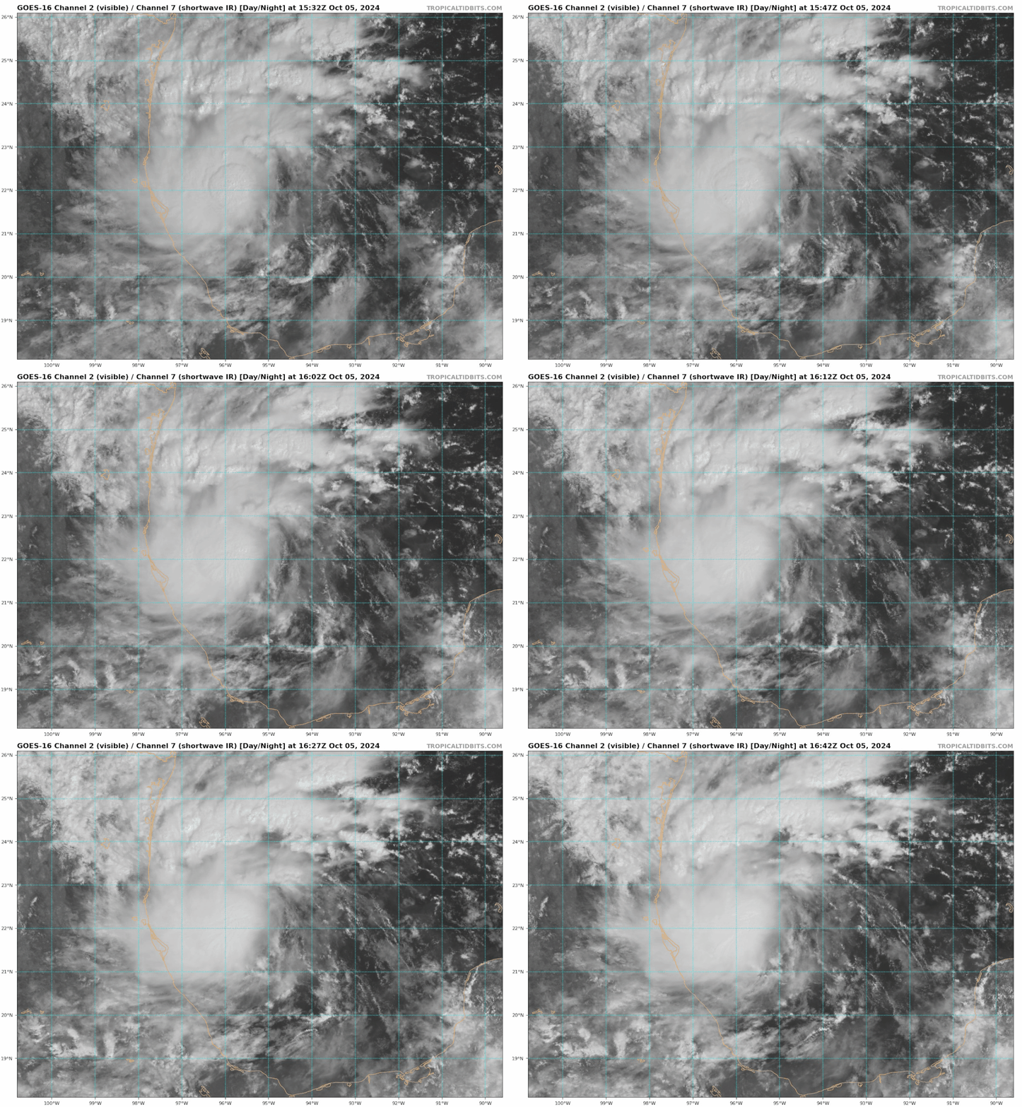
Looks to be organizing to me:

Image
4 likes   

User avatar
got ants?
Tropical Storm
Tropical Storm
Posts: 114
Age: 66
Joined: Sat Sep 03, 2011 3:44 am
Location: Hollywood/Ft Laud

Re: ATL: FOURTEEN - Tropical Depression - Discussion

#209 Postby got ants? » Sat Oct 05, 2024 11:51 am

underthwx wrote:
skillz305 wrote:Treasure Coast here: Got my gas, water, canned food, batteries, flashlights, etc (this is prepping for electrical outage not a doomsday scenario). PLEASE start preparing if you're in Central Florida before mass panic sets in. The gas stations and stores are packed and we are on the east coast. Stay safe everyone and keep your head on a swivel.

Yup....east coast of Florida should be preparing as well....this will be an event that will affect both coasts of Florida unfortunately....I wish it were not so....but it is what it is.....its reassuring to hear that the word is out on soon to be Milton...I wish all of you the best possible outcome...to a growing threat to your region....


Like what we've just seen with Helene (but not to that extent) it's the weather before the storm, that has greater effects away from landfall. Helene had days of rain even before it landed, up ino the Appalachian mountains. And we here in South Florida, not only had rain this morning (over 5" in Hollywood) the wave ahead ofTD 14. I'm not worried about bout wind, but localized flooding is going to be an issue.
2 likes   
This post is NOT AN OFFICIAL FORECAST and should not be used as such. It is just the opinion of the poster and may or may not be backed by sound meteorological data. It is NOT endorsed by any professional institution including storm2k.org. For Official Information please refer to the NHC and NWS products.

BIFF_THE_UNRULY
Tropical Storm
Tropical Storm
Posts: 143
Joined: Fri Jun 28, 2024 2:12 pm

Re: ATL: FOURTEEN - Tropical Depression - Discussion

#210 Postby BIFF_THE_UNRULY » Sat Oct 05, 2024 11:51 am

Xyls wrote:
BIFF_THE_UNRULY wrote:
Hugo1989 wrote:I can’t imagine this eye of a cat 3 moving across the Tampa bay! Water surge, winds and rain would catastrophic. There are too many houses (most of them mansions) around the bay. All the damages causes will be historic. Nobody is ready to watch this scenario!


Well...I can sum it up for you

Its over. The city population would halve over a week.

I live here. It floods awful already with just a rainstorm. But the complacency and the amount of building up here has really exacerbated everything, the draining system is beyond destroyed as it is because of all the growth since 2020

If we get a Category 4 or 5. This city is toast. All these transplants wont stick around, they will go back to wherever they came and the city will be an economic black hole like new orleans was after Katrina. Not to mention Downtown, the Airport and 30% of the rest of the city and suburbs would be completely under storm surge.


Wouldn't just be a local economic black hole. I would question whether the Florida insurance market would survive such a strike and that would have major implications on the housing market/economy of Florida and in turn the United States as a whole.


Yup

The drainage system and series of canals like Sweetwater creek was built in the 1950's and hasn't been improved since. The area literally has 10000% more concrete and population since then. It could in no way withstand this sort of storm.
0 likes   

User avatar
NDG
S2K Supporter
S2K Supporter
Posts: 15446
Joined: Sun Jul 09, 2006 10:14 pm
Location: Orlando, FL

Re: ATL: FOURTEEN - Tropical Depression - Discussion

#211 Postby NDG » Sat Oct 05, 2024 11:52 am

So far today I am in the state of shock. In a way it doesn't surprise me the models are so aggressive with TD14, I knew the potential was there because the jet streak is still far away from it.
I just feel so bad if indeed the GFS's track is correct, many of my favorite beaches in the Tampa area will never be the same for a long time.
My niece in Port Richey lost her house with 4' of water inside, my cousin in Ana Maria lost one of his houses, my aunt in Ana Maria also got her house flooded to Helene. I am sure they are in a worst state of shock than me today.
The GFS has become consistent and persistent, not a good thing for the Tampa Bay area as it had a very good record with Helene and Francine within the 96 hrs forecast range.
6 likes   

underthwx
Category 5
Category 5
Posts: 2360
Joined: Sat Jul 30, 2011 2:14 pm
Location: Brazoria County Texas

Re: ATL: FOURTEEN - Tropical Depression - Discussion

#212 Postby underthwx » Sat Oct 05, 2024 11:53 am

Cloudy and windy here a bit....feeling some fringe effects here....I think there will be some coastal flooding...rip currents for sure....no surfing this one...
0 likes   

BIFF_THE_UNRULY
Tropical Storm
Tropical Storm
Posts: 143
Joined: Fri Jun 28, 2024 2:12 pm

Re: ATL: FOURTEEN - Tropical Depression - Discussion

#213 Postby BIFF_THE_UNRULY » Sat Oct 05, 2024 11:53 am

Of course St Pete, Riverview, Bradenton. All have same problem. Unprecedented growth, no infrastructure improvements to manage water.

Its gonna be a catastrophe. Just prepare and hope the Deflector shield kicks in
0 likes   

Poonwalker
Category 1
Category 1
Posts: 270
Joined: Tue Sep 20, 2022 11:12 am

Re: ATL: FOURTEEN - Tropical Depression - Discussion

#214 Postby Poonwalker » Sat Oct 05, 2024 11:55 am

Zonacane wrote:What is the expected storm surge for a category 4 in Tampa?

This is the worst possible approach for Tampa in terms of surge. It has the entire gulf to work with to push water up over the shallow shelf. They predict 20 feet with a cat 4 in Tampa like this if it comes in just slightly north.
Last edited by Poonwalker on Sat Oct 05, 2024 11:57 am, edited 1 time in total.
3 likes   

User avatar
ScottNAtlanta
Category 5
Category 5
Posts: 2367
Joined: Sat May 25, 2013 3:11 pm
Location: Atlanta, GA

Re: ATL: FOURTEEN - Tropical Depression - Discussion

#215 Postby ScottNAtlanta » Sat Oct 05, 2024 11:57 am

BIFF_THE_UNRULY wrote:
Hugo1989 wrote:I can’t imagine this eye of a cat 3 moving across the Tampa bay! Water surge, winds and rain would catastrophic. There are too many houses (most of them mansions) around the bay. All the damages causes will be historic. Nobody is ready to watch this scenario!


Well...I can sum it up for you

Its over. The city population would halve over a week.

I live here. It floods awful already with just a rainstorm. But the complacency and the amount of building up here has really exacerbated everything, the draining system is beyond destroyed as it is because of all the growth since 2020

If we get a Category 4 or 5. This city is toast. All these transplants wont stick around, they will go back to wherever they came and the city will be an economic black hole like new orleans was after Katrina. Not to mention Downtown, the Airport and 30% of the rest of the city and suburbs would be completely under storm surge. Pinellas would be toast aswell

Add to the mixture that homeowners insurance that was poised to go even higher after Helene, will become almost unaffordable if this hits as the models are forecasting. It could make the states insurer of last resort insolvent.
1 likes   
The posts in this forum are NOT official forecast and should not be used as such. They are just the opinion of the poster and may or may not be backed by sound meteorological data. They are NOT endorsed by any professional institution or storm2k.org. For official information, please refer to the NHC and NWS products.

User avatar
MGC
S2K Supporter
S2K Supporter
Posts: 5899
Joined: Sun Mar 23, 2003 9:05 pm
Location: Pass Christian MS, or what is left.

Re: ATL: FOURTEEN - Tropical Depression - Discussion

#216 Postby MGC » Sat Oct 05, 2024 11:58 am

Rather disturbing how quickly 92L developed into TD14. Depression looks to be coming together at a brisk clip. Conditions in the GOM currently look very favorable for intensification. No dry air over the Gulf, warm waters and the loop current is in the cyclone's path. If the jet can remain to the north of future Milton than substantial intensification will likely occur. Looks like it might be another big one......MGC
5 likes   

User avatar
cycloneye
Admin
Admin
Posts: 145294
Age: 68
Joined: Thu Oct 10, 2002 10:54 am
Location: San Juan, Puerto Rico

Re: ATL: FOURTEEN - Tropical Depression - Discussion

#217 Postby cycloneye » Sat Oct 05, 2024 11:59 am

Check the many missions that will fly at the recon thread
2 likes   
Visit the Caribbean-Central America Weather Thread where you can find at first post web cams,radars
and observations from Caribbean basin members Click Here

dukeblue219
S2K Supporter
S2K Supporter
Posts: 535
Joined: Fri Sep 30, 2016 3:52 pm

Re: ATL: FOURTEEN - Tropical Depression - Discussion

#218 Postby dukeblue219 » Sat Oct 05, 2024 12:00 pm

Given we're 96 hours or less from landfall I'm surprised there isn't a recon flight available sooner than tomorrow morning
2 likes   

underthwx
Category 5
Category 5
Posts: 2360
Joined: Sat Jul 30, 2011 2:14 pm
Location: Brazoria County Texas

Re: ATL: FOURTEEN - Tropical Depression - Discussion

#219 Postby underthwx » Sat Oct 05, 2024 12:06 pm

MGC wrote:Rather disturbing how quickly 92L developed into TD14. Depression looks to be coming together at a brisk clip. Conditions in the GOM currently look very favorable for intensification. No dry air over the Gulf, warm waters and the loop current is in the cyclone's path. If the jet can remain to the north of future Milton than substantial intensification will likely occur. Looks like it might be another big one......MGC

I agree....and that is alarming to me....the potential that this cyclone has to develop into a major hurricane has me worried for Floridians....the next NHC update should support what you are saying....what a difference a day makes with tropical weather....as I said in an earlier post....I have been lookin at satellite images of the cyclone....and it is clearly evident that it's becoming better and better organized with each passing hour....
0 likes   

zzzh
Category 3
Category 3
Posts: 834
Joined: Thu Sep 02, 2021 1:13 pm

Re: ATL: FOURTEEN - Tropical Depression - Discussion

#220 Postby zzzh » Sat Oct 05, 2024 12:10 pm

Image
A more detailed ascat.
2 likes   


Return to “2024”

Who is online

Users browsing this forum: No registered users and 2 guests