
https://twitter.com/BigJoeBastardi/status/1842151685088514226
Possible development in the Gulf of Mexico (Is Invest 92L)
Moderator: S2k Moderators
Forum rules

The posts in this forum are NOT official forecasts and should not be used as such. They are just the opinion of the poster and may or may not be backed by sound meteorological data. They are NOT endorsed by any professional institution or STORM2K. For official information, please refer to products from the National Hurricane Center and National Weather Service.
Re: Possible development in the Gulf of Mexico (0/40)
2 likes
The following post is NOT an official forecast and should not be used as such. It is just the opinion of the poster and may or may not be backed by sound meteorological data. It is NOT endorsed by any professional institution including storm2k.org For Official Information please refer to the NHC and NWS products.

Re: Possible development in the Gulf of Mexico (0/30)
otowntiger wrote::Dglad you got a laugh!Steve wrote:otowntiger wrote:I can just about guarantee that the very next run will be 100% different. I bet it will show no discernible vorticity.
I’m going to disagree. Models have called for a hook east system for a week. 00z’s will show some action. But I did laugh before posting so all good.But as I predicted the very next gfs run just showing a blob.
Haha. 6z as well. All the other globals worth looking at trended weaker at 00z but still have a 990's TS type system coming in farther south than they had been. GFS doesn't resolve the CAG and ejects/emits out a couple of pulses of energy. It's the odd one out for now.
0 likes
-
wzrgirl1

- S2K Supporter

- Posts: 1360
- Joined: Sat Sep 04, 2004 6:44 am
- Location: Pembroke Pines, Florida
Re: Limited development in the Gulf of Mexico (Interaction with Frontal Boundary) (0/30)
chaser1 wrote:wzrgirl1 wrote:Michele B wrote:
I know that. I live in the area. But when I look at what those states north of us are dealing with, I can handle a little flooding. My area doesn't flood terribly, but we had a time of it with Ian. First the wind, and then the flooding.
Just saying, I'll handle the flood rather than the wind if given a choice,
Just renewed my flood insurance policy even though I am not in a flood zone. Just can't take the chance here in southwest Broward County.
Good move by you! I used to live in Pembroke Shores on a large lake and I wouldn't have lived there without Flood insurance!
My first home was in Pembroke Shores! It was the townhomes when you first drive into the complex on the right. I loved living there it just became too small for my household. Now I am in Silver Lakes.
0 likes
-
toad strangler

- S2K Supporter
- Posts: 4546
- Joined: Sun Jul 28, 2013 3:09 pm
- Location: Earth
- Contact:
Re: Possible development in the Gulf of Mexico (0/40)
A snip from Michael Lowry’s newsletter this morning…
Earlier in the week, models were honing in on the eastern piece of this broader Central American Gyre from the western Caribbean that’s since pivoted over the south-central Gulf.
In recent days, however, the models have latched on to the remnants of Tropical Depression 11 from the eastern Pacific instead that’s crossing southern Mexico and forecast to emerge over the southwestern Gulf of Mexico this weekend. It’s this piece of spin farther southwest that’s now forecast to be the dominant focus of any tropical development next week.
0 likes
My Weather Station
https://www.wunderground.com/dashboard/pws/KFLPORTS603
https://www.wunderground.com/dashboard/pws/KFLPORTS603
-
skillz305
- Category 1

- Posts: 312
- Joined: Sat Sep 08, 2018 11:10 am
- Location: Miami, Florida --> Vero Beach, Florida
Re: Possible development in the Gulf of Mexico (0/40)
Where is wxman57 when we need him? He was bearish on this a couple days ago. Need his updated insight. In his expert opinion of course. Central Florida here.
0 likes
 Hurricanes: Andrew 1992 - Irene 1999 - Frances 2004 - Jeanne 2004 - Katrina 2005 - Wilma 2005 - Matthew 2016 - Irma 2017 - Ian 2022 - Nicole 2022 - Milton 2024
Re: Possible development in the Gulf of Mexico (0/40)
Rain bomb has always been the primary hazard regardless of development and if anything that risk seems to be increasing over the southern half of the peninsula. WPC now shows a large area of 10"+ with 15"+ pixels now showing over the eastern Gulf. Someone is likely to bag a double digit rain event...and many of these areas are already wet so at a minimum a flood threat is likely to evolve for someone.
0 likes
-
jlauderdal
- S2K Supporter
- Posts: 7240
- Joined: Wed May 19, 2004 5:46 am
- Location: NE Fort Lauderdale
- Contact:
Re: Possible development in the Gulf of Mexico (0/40)
skillz305 wrote:Where is wxman57 when we need him? He was bearish on this a couple days ago. Need his updated insight. In his expert opinion of course. Central Florida here.
Prepare for 10+ inches of rain and be aware you could see up to a 2 next week, its as simple as that at this point. The setup is as clear as day as far as precip goes, who gets the big totals can't be predicted this far out but it will be widespread. I have 2.31 in the bucket since midnight and this has nothing to do with what's coming as this came in on easterly flow, the atmosphere starts its flip tomorrow as the steering flow turns. The pre-event was not helpful to Atlanta up to western nc; these things matter in the longer term. WC of Florida is still saturated from Helene and Tampa had 5+ yesterday.
0 likes
-
Blown Away

- S2K Supporter
- Posts: 10253
- Joined: Wed May 26, 2004 6:17 am
Re: Possible development in the Gulf of Mexico (0/40)
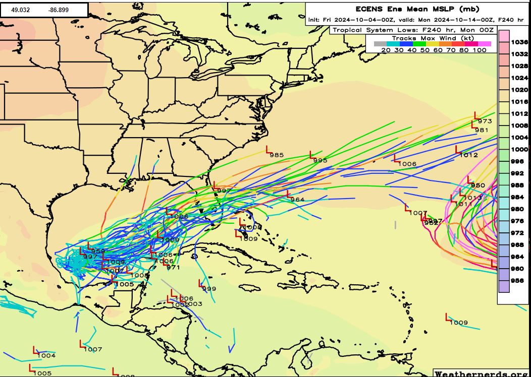
00z ECENS... Many canes in the ensemble bunch!
0 likes
Hurricane Eye Experience: David 79, Irene 99, Frances 04, Jeanne 04, Wilma 05… Hurricane Brush Experience: Andrew 92, Erin 95, Floyd 99, Matthew 16, Irma 17, Ian 22, Nicole 22…
-
Weathertracker96
- Tropical Storm

- Posts: 150
- Joined: Mon Oct 16, 2023 3:41 pm
Re: Possible development in the Gulf of Mexico (0/40)
ICON is trending stronger so far. We’ll see how the rest of run plays out
0 likes
-
SFLcane

- S2K Supporter
- Posts: 10281
- Age: 48
- Joined: Sat Jun 05, 2010 1:44 pm
- Location: Lake Worth Florida
Re: Possible development in the Gulf of Mexico (0/40)
Weathertracker96 wrote:ICON is trending stronger so far. We’ll see how the rest of run plays out
1 likes
-
redingtonbeach
- Tropical Depression

- Posts: 65
- Joined: Mon Sep 04, 2017 12:05 am
Re: Possible development in the Gulf of Mexico (0/40)
Hurricane models tend to move west in the days approaching landfall. In this case, that would be a more northerly path for the west coast of Florida if that holds true. So that would put landfall somewhere north of Tampa Bay (Crystal River?) which could dump copious amounts of water over an already saturated Central Florida region. Prayers that this storm remains weak.
0 likes
-
SFLcane
- S2K Supporter
- Posts: 10281
- Age: 48
- Joined: Sat Jun 05, 2010 1:44 pm
- Location: Lake Worth Florida
Re: Possible development in the Gulf of Mexico (0/40)
redingtonbeach wrote:Hurricane models tend to move west in the days approaching landfall. In this case, that would be a more northerly path for the west coast of Florida if that holds true. So that would put landfall somewhere north of Tampa Bay (Crystal River?) which could dump copious amounts of water over an already saturated Central Florida region. Prayers that this storm remains weak.
Its not going north as far north as tampa (in my opinion) steering is such anything that anything forms will be shunted almost in a ENE fashion. Lets hope nothing strong developes
1 likes
-
Emmett_Brown

- Category 5

- Posts: 1433
- Joined: Wed Aug 24, 2005 9:10 pm
- Location: Sarasota FL
Re: Possible development in the Gulf of Mexico (0/40)
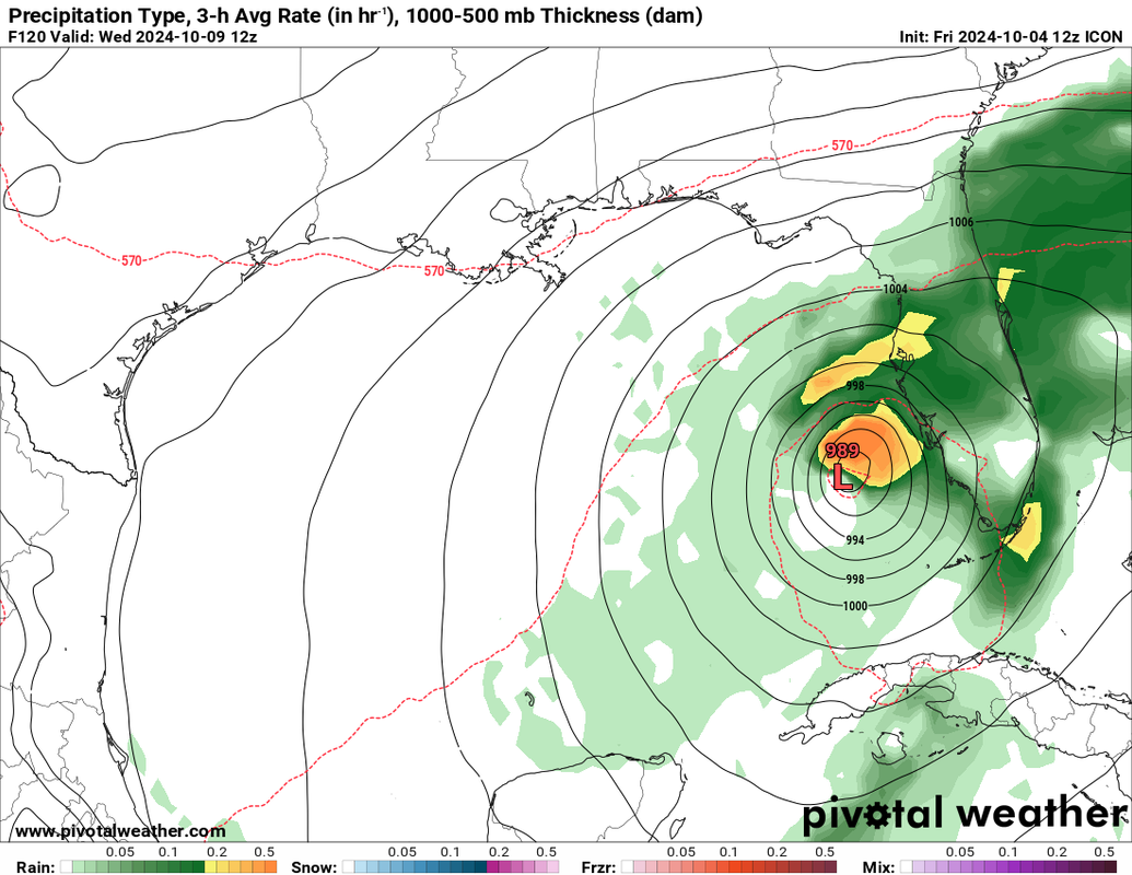
12Z Icon depicts a storm with a larger than normal wind field, which is typical for late season storms in this area
0 likes
-
cycloneye

- Admin

- Posts: 149670
- Age: 69
- Joined: Thu Oct 10, 2002 10:54 am
- Location: San Juan, Puerto Rico
Re: Possible development in the Gulf of Mexico (0/40)
GFS with the strongest run yet.

1 likes
Visit the Caribbean-Central America Weather Thread where you can find at first post web cams,radars
and observations from Caribbean basin members Click Here
and observations from Caribbean basin members Click Here
-
cycloneye
- Admin
- Posts: 149670
- Age: 69
- Joined: Thu Oct 10, 2002 10:54 am
- Location: San Juan, Puerto Rico
Re: Possible development in the Gulf of Mexico (0/40)
982 mbs Tampa.

0 likes
Visit the Caribbean-Central America Weather Thread where you can find at first post web cams,radars
and observations from Caribbean basin members Click Here
and observations from Caribbean basin members Click Here
-
Emmett_Brown
- Category 5
- Posts: 1433
- Joined: Wed Aug 24, 2005 9:10 pm
- Location: Sarasota FL
Re: Possible development in the Gulf of Mexico (0/40)
12Z CMC is very different, develops it but keeps it near the N coast of the Yucatan by next Wed
1 likes
-
Emmett_Brown
- Category 5
- Posts: 1433
- Joined: Wed Aug 24, 2005 9:10 pm
- Location: Sarasota FL
Re: Possible development in the Gulf of Mexico (0/40)
This disturbance seems invest worthy, especially considering some models are showing landfall as early as Tues/Wed
4 likes
-
Hypercane_Kyle

- Category 5
- Posts: 3465
- Joined: Sat Mar 07, 2015 7:58 pm
- Location: Cape Canaveral, FL
Re: Possible development in the Gulf of Mexico (0/40)
The GFS has absolutely no clue, the amount of inconsistency at this close of a range is absurd.
1 likes
My posts are my own personal opinion, defer to the National Hurricane Center (NHC) and other NOAA products for decision making during hurricane season.
Who is online
Users browsing this forum: gib, Majestic-12 [Bot] and 176 guests