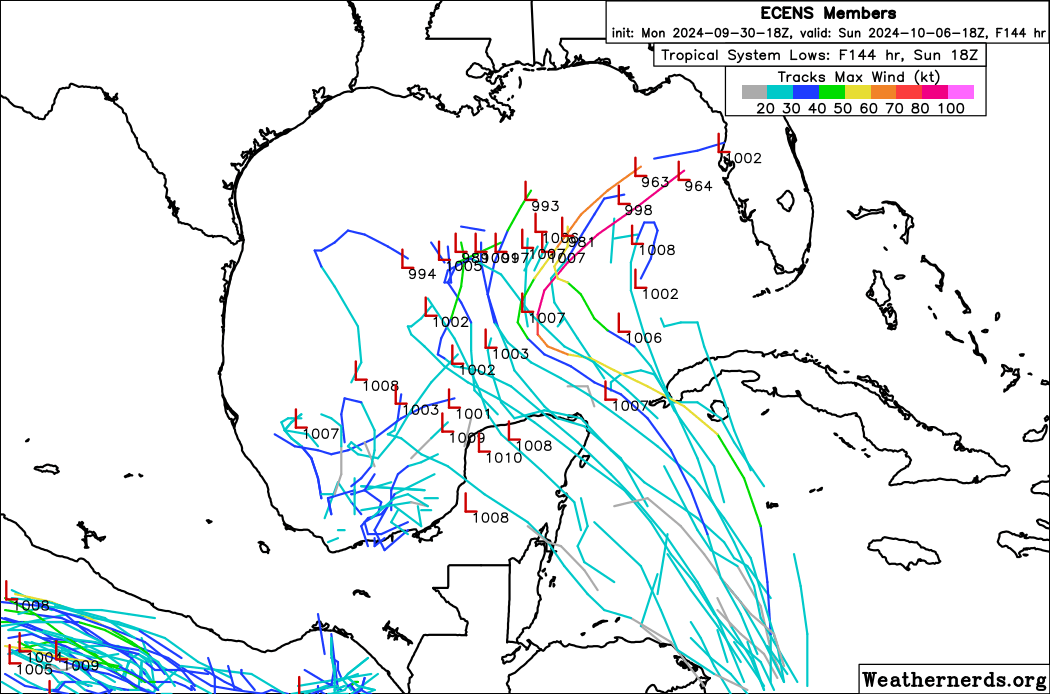
I was on another page and it seems the 18z EURO ensembles are still developing and a few members get strong.
Im on my phone so not able to post image.
I do wonder what is causing disagreement between the GFS and Euro?
Possible development in the Gulf of Mexico (Is Invest 92L)
Moderator: S2k Moderators
Forum rules

The posts in this forum are NOT official forecasts and should not be used as such. They are just the opinion of the poster and may or may not be backed by sound meteorological data. They are NOT endorsed by any professional institution or STORM2K. For official information, please refer to products from the National Hurricane Center and National Weather Service.
-
Weathertracker96
- Tropical Storm

- Posts: 150
- Joined: Mon Oct 16, 2023 3:41 pm
-
wxman57

- Moderator-Pro Met

- Posts: 23175
- Age: 68
- Joined: Sat Jun 21, 2003 8:06 pm
- Location: Houston, TX (southwest)
Re: Possible development in the NW Caribbean / GOM (10/40)
The trend I see is for later development of a weaker, frontal low by around Saturday. Nothing is indicating any strong TS, possibly just a frontal low. With each model having a different solution and timing, all we can do is wait and see of the models start to agree on a solution. Lots of dry air and wind shear to contend with. This will not be another Helene, I'm fairly confident of that.
11 likes
-
ConvergenceZone
.gif)
- Category 5

- Posts: 5241
- Joined: Fri Jul 29, 2005 1:40 am
- Location: Northern California
Re: Possible development in the NW Caribbean / GOM (10/40)
wxman57 wrote:The trend I see is for later development of a weaker, frontal low by around Saturday. Nothing is indicating any strong TS, possibly just a frontal low. With each model having a different solution and timing, all we can do is wait and see of the models start to agree on a solution. Lots of dry air and wind shear to contend with. This will not be another Helene, I'm fairly confident of that.
This!
0 likes

-
cycloneye

- Admin

- Posts: 149696
- Age: 69
- Joined: Thu Oct 10, 2002 10:54 am
- Location: San Juan, Puerto Rico
Re: Possible development in the NW Caribbean / GOM (10/40)
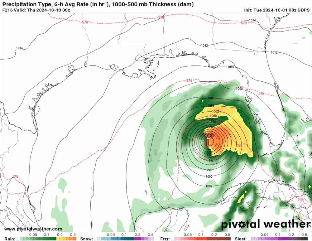
00z ICON much stronger run with 970 mbs. 


1 likes
Visit the Caribbean-Central America Weather Thread where you can find at first post web cams,radars
and observations from Caribbean basin members Click Here
and observations from Caribbean basin members Click Here
-
REDHurricane

- Category 1

- Posts: 438
- Age: 28
- Joined: Sun Jul 03, 2022 2:36 pm
- Location: Northeast Pacific Ocean
Re: Possible development in the NW Caribbean / GOM (10/40)
ICON may be the only one really showing any development past a weak TS (12z ICON shows a low forming over the BoC over the next several days that turns into a 991mb TS approaching Florida directly from the west at 00z Tuesday 10/8, and 18z ICON shows a slightly stronger disturbance at +120 hours compared to 12z), but I've decided to jump on the ICON bandwagon until it actually whiffs on a Gulf setup that other models get right. There's enough anecdotal (and probably actual if anyone who isn't me wants to investigate) data in my mind at this point over recent storms/seasons to say that ICON is just more skillful at predicting tropical activity in the Gulf than the other global models and therefore ICON's Gulf solutions are more likely to verify for any given setup.
Regardless, it seems very unlikely right now that this will amount to anything more than a cat 1 so the main threat will probably be the rain/possible storm surge depending on track. Looks like it'll be moving quickly so hopefully that will help minimize any impacts
Regardless, it seems very unlikely right now that this will amount to anything more than a cat 1 so the main threat will probably be the rain/possible storm surge depending on track. Looks like it'll be moving quickly so hopefully that will help minimize any impacts
1 likes
-
REDHurricane
- Category 1
- Posts: 438
- Age: 28
- Joined: Sun Jul 03, 2022 2:36 pm
- Location: Northeast Pacific Ocean
Re: Possible development in the NW Caribbean / GOM (10/40)
cycloneye wrote:00z ICON much stronger run with 970 mbs.
https://i.imgur.com/dAAyODy.gif
https://i.imgur.com/znrnqq4.png
Saw this immediately after posting my comment -- yeah, let's just hope ICON is wrong this time.
3 likes
-
jlauderdal
- S2K Supporter

- Posts: 7240
- Joined: Wed May 19, 2004 5:46 am
- Location: NE Fort Lauderdale
- Contact:
Re: Possible development in the NW Caribbean / GOM (10/40)
SFLcane wrote:https://i.postimg.cc/d1q6Yzgt/IMG-9530.gif
Stop with the south florida threat, our streak is in jeopardy. Honestly, hoping it comes our way, keep it as far away from Helene victims as possible. No model support for it affecting our neighbors in Appalachia so that is positive. Fun Fact, I was in Lake Toxaway(south of Asheville) on vaca during covid and a TS went over our heads, knocked out power for 12 hours, rivers were raging but in their banks. Its a whole different story when there is elevation.
4 likes
-
eastcoastFL

- Category 5
- Posts: 3996
- Age: 44
- Joined: Thu Apr 12, 2007 12:29 pm
- Location: Palm City, FL
Re: Possible development in the NW Caribbean / GOM (10/40)
wzrgirl1 wrote:eastcoastFL wrote:18z ICON is spinning something up in the BOC. It also has a low south of PR.
https://www.tropicaltidbits.com/analysi ... atl_39.png
I am glad I chose 6 storms to form in the October poll. I actually think it could be more. It will be a very active October. At what point do the storms count towards our numbers? Is it when it becomes a TD? Or when it has an actual name?
6 sounds like a good bet.
1 likes
Personal Forecast Disclaimer:
The posts in this forum are NOT official forecast and should not be used as such. They are just the opinion of the poster and may or may not be backed by sound meteorological data. They are NOT endorsed by any professional institution or storm2k.org. For official information, please refer to the NHC and NWS products.
The posts in this forum are NOT official forecast and should not be used as such. They are just the opinion of the poster and may or may not be backed by sound meteorological data. They are NOT endorsed by any professional institution or storm2k.org. For official information, please refer to the NHC and NWS products.
-
Hypercane_Kyle

- Category 5
- Posts: 3465
- Joined: Sat Mar 07, 2015 7:58 pm
- Location: Cape Canaveral, FL
Re: Possible development in the NW Caribbean / GOM (10/40)
06z GFS with a minimal hurricane into Tampa, Tuesday Oct 8. Originates from the BOC.
2 likes
My posts are my own personal opinion, defer to the National Hurricane Center (NHC) and other NOAA products for decision making during hurricane season.
-
eastcoastFL
- Category 5
- Posts: 3996
- Age: 44
- Joined: Thu Apr 12, 2007 12:29 pm
- Location: Palm City, FL
Re: Possible development in the NW Caribbean / GOM (10/40)
REDHurricane wrote:ICON may be the only one really showing any development past a weak TS (12z ICON shows a low forming over the BoC over the next several days that turns into a 991mb TS approaching Florida directly from the west at 00z Tuesday 10/8, and 18z ICON shows a slightly stronger disturbance at +120 hours compared to 12z), but I've decided to jump on the ICON bandwagon until it actually whiffs on a Gulf setup that other models get right. There's enough anecdotal (and probably actual if anyone who isn't me wants to investigate) data in my mind at this point over recent storms/seasons to say that ICON is just more skillful at predicting tropical activity in the Gulf than the other global models and therefore ICON's Gulf solutions are more likely to verify for any given setup.
Regardless, it seems very unlikely right now that this will amount to anything more than a cat 1 so the main threat will probably be the rain/possible storm surge depending on track. Looks like it'll be moving quickly so hopefully that will help minimize any impacts
I'm noticing that the ensembles that take the same path as the Icon end up with a similar solution on intensity. Maybe it's just a matter of going through the loop current and firing off of the warm pool there. The two ensembles going through this area are in the 960s.
1 likes
Personal Forecast Disclaimer:
The posts in this forum are NOT official forecast and should not be used as such. They are just the opinion of the poster and may or may not be backed by sound meteorological data. They are NOT endorsed by any professional institution or storm2k.org. For official information, please refer to the NHC and NWS products.
The posts in this forum are NOT official forecast and should not be used as such. They are just the opinion of the poster and may or may not be backed by sound meteorological data. They are NOT endorsed by any professional institution or storm2k.org. For official information, please refer to the NHC and NWS products.
Re: Possible development in the NW Caribbean / GOM (10/40)
eastcoastFL wrote:REDHurricane wrote:ICON may be the only one really showing any development past a weak TS (12z ICON shows a low forming over the BoC over the next several days that turns into a 991mb TS approaching Florida directly from the west at 00z Tuesday 10/8, and 18z ICON shows a slightly stronger disturbance at +120 hours compared to 12z), but I've decided to jump on the ICON bandwagon until it actually whiffs on a Gulf setup that other models get right. There's enough anecdotal (and probably actual if anyone who isn't me wants to investigate) data in my mind at this point over recent storms/seasons to say that ICON is just more skillful at predicting tropical activity in the Gulf than the other global models and therefore ICON's Gulf solutions are more likely to verify for any given setup.
Regardless, it seems very unlikely right now that this will amount to anything more than a cat 1 so the main threat will probably be the rain/possible storm surge depending on track. Looks like it'll be moving quickly so hopefully that will help minimize any impacts
I'm noticing that the ensembles that take the same path as the Icon end up with a similar solution on intensity. Maybe it's just a matter of going through the loop current and firing off of the warm pool there. The two ensembles going through this area are in the 960s.
That would be a Cat. 2 i believe.
0 likes
-
redingtonbeach
- Tropical Depression

- Posts: 65
- Joined: Mon Sep 04, 2017 12:05 am
Re: Possible development in the NW Caribbean / GOM (10/40)
A Cat anything right now into St. Pete would be beyond devastating.
5 likes
-
cycloneye
- Admin
- Posts: 149696
- Age: 69
- Joined: Thu Oct 10, 2002 10:54 am
- Location: San Juan, Puerto Rico
Re: Possible development in the NW Caribbean / GOM (10/40)
8 AM:
Northwestern Caribbean Sea and Gulf of Mexico:
Disorganized showers and thunderstorms located over the southwestern
Caribbean Sea are associated with a trough of low pressure.
Environmental conditions could support some gradual development of
this system, and a tropical depression could form towards the end of
this week or this weekend while it moves generally northwestward
over the northwestern Caribbean Sea and into the Gulf of Mexico.
Interests along the U.S. Gulf Coast should continue to monitor the
progress of this system.
* Formation chance through 48 hours...low...10 percent.
* Formation chance through 7 days...medium...40 percent.
0 likes
Visit the Caribbean-Central America Weather Thread where you can find at first post web cams,radars
and observations from Caribbean basin members Click Here
and observations from Caribbean basin members Click Here
Re: Possible development in the NW Caribbean / GOM (10/40)
cycloneye wrote:00z ICON much stronger run with 970 mbs.
https://i.imgur.com/dAAyODy.gif
https://i.imgur.com/znrnqq4.png
The ICON has had the super hot hand all year
0 likes
-
wxman57
- Moderator-Pro Met
- Posts: 23175
- Age: 68
- Joined: Sat Jun 21, 2003 8:06 pm
- Location: Houston, TX (southwest)
Re: Possible development in the NW Caribbean / GOM (10/40)
6Z ICON has a weak frontal low over the south-central Gulf Saturday night. It has a moderate cold front moving south across the northern Gulf. Nothing like the 06Z run. Models are all trending away from any significant tropical development in favor of two cold fronts - one tonight and one on Saturday - moving out into the Gulf. Tropical development chances are decreasing.
10 likes
-
Emmett_Brown

- Category 5
- Posts: 1433
- Joined: Wed Aug 24, 2005 9:10 pm
- Location: Sarasota FL
-
BIFF_THE_UNRULY
- Tropical Storm
- Posts: 143
- Joined: Fri Jun 28, 2024 2:12 pm
Re: Possible development in the NW Caribbean / GOM (10/40)
redingtonbeach wrote:A Cat anything right now into St. Pete would be beyond devastating.
Agree, My timeshare in Reddington beach got destroyed by Storm Surge
Place has been there since 1950's and never once had surge go 6 feet into the lobby.
2 likes
-
Stormlover70
- Tropical Storm
- Posts: 194
- Age: 56
- Joined: Fri Jun 21, 2024 5:31 am
- Location: New port richey
Re: Possible development in the NW Caribbean / GOM (10/40)
even heavy rain would be bad. Sorry about your timeshare.BIFF_THE_UNRULY wrote:redingtonbeach wrote:A Cat anything right now into St. Pete would be beyond devastating.
Agree, My timeshare in Reddington beach got destroyed by Storm Surge
Place has been there since 1950's and never once had surge go 6 feet into the lobby.
0 likes
Who is online
Users browsing this forum: Old-TimeCane and 158 guests