The curious case of CONUS Cat 4+ landfalls in recent years -- especially the Gulf

This is the general tropical discussion area. Anyone can take their shot at predicting a storms path.

Moderator: S2k Moderators

Forum rules

The posts in this forum are NOT official forecasts and should not be used as such. They are just the opinion of the poster and may or may not be backed by sound meteorological data. They are NOT endorsed by any professional institution or STORM2K. For official information, please refer to products from the National Hurricane Center and National Weather Service.

Help Support Storm2K
Message
Author
User avatar
Teban54
Category 5
Category 5
Posts: 3204
Joined: Sat May 19, 2018 1:19 pm

The curious case of CONUS Cat 4+ landfalls in recent years -- especially the Gulf

#1 Postby Teban54 » Mon Sep 30, 2024 8:28 am

This post was originally written in the "How strong will Helene get?" thread, but I figured this observation is worth its own thread.

(Updated October 10, 2024)


Cyclenall wrote:I didn't know where to put this but Helene continues the trend of an major increase in landfalling CAT4+ hurricanes since 2017. Certainly for the US but basin-wide too. Even during the historic 2003-2005 period it was just Charley. Then before that it was Andrew!

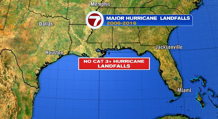
Here are the number of Cat 3 and Cat 4 CONUS landfalls compared in the 1995-2009 period vs. 2010-2024 period (so far). The two periods nicely divide up the current +AMO era evenly. Both periods include very active and/or destructive years (e.g. 1995, 1999, 2004, 2005, 2010, 2017, 2020).

1995-2009:
  • Cat 3+: 10 hurricanes (Opal, Fran, Bret 1999, Charley, Ivan, Jeanne, Dennis, Katrina, Rita, Wilma)
  • Cat 4+: 1 hurricane (Charley)
2010-2024:
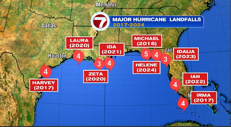
  • Cat 3+: 10 hurricanes (Harvey, Irma, Michael, Laura, Zeta, Ida, Ian, Idalia, Helene, Milton)
  • Cat 4+: 7 hurricanes (Harvey, Irma, Michael, Laura, Ida, Ian, Helene)
  • Cat 5: 1 hurricane (Michael)
While the number of Cat 3+ CONUS landfalls was similar in the two periods, there was a major uptick in Cat 4+ CONUS landfalls. In fact, during 2010-24, more hurricanes hit CONUS as Cat 4/5 than Cat 3!

Gulf of Mexico was clearly the hot spot for such landfalls: Every single MH CONUS landfall since 2010 (equivalently, since 2017) did so on the Gulf coast. Whereas during 1995-2009, two of the 10 MH landfalls were on the US East Coast (Fran, Jeanne). However, the lack of East Coast MH landfalls may be a streak of good luck or a coincidence, as there were no shortage of threats (Matthew, Irma, Florence, Dorian).

Graphics from this tweet by Jeremy Reiner illustrates this perfectly:
Image

Image

Another trend in recent years is a significant increase in storms that strengthened all the way until landfall. In 1995-2009, 7 out of 10 MH landfalls were weakening at CONUS landfall, either slightly or significantly. But in 2010-2024, 7 out of 10 MH landfalls intensified, typically rapidly, until they were stopped by land.

Furthermore, MH landfalls have become more evenly distributed across individual years. Of the 10 MH landfalls in the earlier half of this +AMO era, 7 occurred within a span of 2 years, 2004 and 2005, both of which are legendary seasons themselves. That's not the case for the more recent half, where each year contributed at most 2 MH landfalls on CONUS (unless 2024's late season changes things). Yet, such intense hurricanes on the Gulf had become almost a yearly experience: 7 of the past 8 years had a CONUS MH landfall, and 6 of the 8 had a Cat 4+. They include El Nino years (2018, 2023) and years with near-average ACE (2022). The threat from a highly destructive major hurricane is clearly no longer limited to hyperactive years, shattering an impression that people may have gotten earlier from 2004-05.

Keep in mind, this is despite the latter period containing the very inactive years of 2013-15, and the textbook example 2010 with hyperactivity but sparing CONUS entirely. If 2010 had more west-based tracks typical of La Ninas, 2013 played out as forecast, and even the earlier parts of 2022 and 2024 were more active, the number may have been even higher.

A caveat is that the above calculations only consider peak wind speed, which is not the end-all (as we've just seen with Helene). Many destructive Cat 1-2 or even TS landfalls were omitted. However, they're also roughly evenly distributed across the two periods (Bertha 1996, Georges, Floyd, Allison, Lili, Isabel, Frances, Gustav, Ike / Irene, Isaac 2012, Sandy, Matthew, Florence, Imelda, Isaias, Sally, Beryl).
Last edited by Teban54 on Thu Oct 10, 2024 10:34 am, edited 1 time in total.
11 likes   

User avatar
toad strangler
S2K Supporter
S2K Supporter
Posts: 4543
Joined: Sun Jul 28, 2013 3:09 pm
Location: Earth
Contact:

Re: The curious case of CONUS Cat 4+ landfalls in recent years -- especially the Gulf

#2 Postby toad strangler » Mon Sep 30, 2024 8:56 am

I guess including 2005 would ruin the GHOST TOWN of landfalls. Wilma being dissed :lol:
1 likes   

User avatar
Teban54
Category 5
Category 5
Posts: 3204
Joined: Sat May 19, 2018 1:19 pm

Re: The curious case of CONUS Cat 4+ landfalls in recent years -- especially the Gulf

#3 Postby Teban54 » Mon Sep 30, 2024 9:03 am

Another way to see this is that the 8-year period of 2017-2024 has produced more than half as many Cat 4+ CONUS landfalls as the 67-year period from 1950 (satellite era) to 2016:

  • 1950 - 2016: 12 Cat 4+ hurricanes (King 1950, Hazel 1954, Gracie 1959, Donna 1960, Carla 1961, Betsy 1965, Camille 1969, Celia 1970, Frederic 1979, Hugo 1989, Andrew 1992, Charley 2004)
  • 2017 - 2024: 7 Cat 4+ hurricanes (Harvey 2017, Irma 2017, Michael 2018, Laura 2020, Ida 2021, Ian 2022, Helene 2024)
Even during the 1950-60s period when Cat 4+ landfalls were rather frequent, to get 7 such landfalls, you still needed at least 17 years (1954-1970).
3 likes   

User avatar
toad strangler
S2K Supporter
S2K Supporter
Posts: 4543
Joined: Sun Jul 28, 2013 3:09 pm
Location: Earth
Contact:

Re: The curious case of CONUS Cat 4+ landfalls in recent years -- especially the Gulf

#4 Postby toad strangler » Mon Sep 30, 2024 9:19 am

Charley dissed too in 2004 :D
But I get it. The context was that continuous dry spell.
0 likes   

SconnieCane
Category 4
Category 4
Posts: 998
Joined: Thu Aug 02, 2018 5:29 pm
Location: Madison, WI

Re: The curious case of CONUS Cat 4+ landfalls in recent years -- especially the Gulf

#5 Postby SconnieCane » Mon Sep 30, 2024 9:23 am

Also worth noting that ALL of the CONUS major hurricane landfalls in the spate which began in 2017; and all but one (Jeanne) of the prior spate in 2004-'05 have been on the Gulf coast. I grew up in the '90s with Hugo and Andrew as THE recent Atlantic major hurricane landfalls of record - only three years apart; so I got a skewed perception of how common Cat. 4+ landfalls along the Eastern Seaboard really are. Obviously that was inaccurate, but I'm really surprised at how much of a unicorn East Coast MH landfalls have become. Jeanne was the last anywhere along the coast (and Katrina the following year, prior to its Gulf infamy, was the last hurricane of ANY category to landfall in Florida from the east); and my memory is getting fuzzy on the last major north of Florida. Fran '96?

IIRC at some point there was reasonably strong model support for each Matthew, Irma, Florence and Dorian to make a landfall somewhere on the East Coast as a MH, but something shifted with either the steering and/or intensity to prevent that from happening.
Last edited by SconnieCane on Mon Sep 30, 2024 9:34 am, edited 2 times in total.
2 likes   

User avatar
Kazmit
Category 5
Category 5
Posts: 2124
Age: 22
Joined: Mon Jul 25, 2016 8:49 am
Location: Williamsburg, VA / Bermuda

Re: The curious case of CONUS Cat 4+ landfalls in recent years -- especially the Gulf

#6 Postby Kazmit » Mon Sep 30, 2024 9:25 am

Seems like a key difference is the number of "home-grown" systems that don't even develop until less than 5 days before landfall. Aided of course by rapid intensification just before landfall like you said. With warming SSTs over the past several decades, I think it's reasonable to assume that systems that pop out of nowhere are going to become a more common occurrence.
4 likes   
Igor 2010, Sandy 2012, Fay 2014, Gonzalo 2014, Joaquin 2015, Nicole 2016, Humberto 2019

I am only a tropical weather enthusiast. My predictions are not official and may or may not be backed by sound meteorological data. For official information, please refer to the NHC and NWS products.

User avatar
Teban54
Category 5
Category 5
Posts: 3204
Joined: Sat May 19, 2018 1:19 pm

Re: The curious case of CONUS Cat 4+ landfalls in recent years -- especially the Gulf

#7 Postby Teban54 » Mon Sep 30, 2024 9:42 am

SconnieCane wrote:and my memory is getting fuzzy on the last major north of Florida. Fran '96?

Yes, Fran 1996 was the last major hurricane to landfall on the East Coast of CONUS north of Florida at such intensity. Before that it was Hugo 1989, and before that, Gracie 1959. (Emily 1993 apparently produced MH winds in NC despite not making landfall.)

The 1950s were quite hectic for the East Coast north of Florida, with Carol 1954, Hazel 1954 and Helene 1958 all producing MH winds (plus Edna 1954 also doing significant impacts). I don't think such a bad decade happened again for much of the East Coast ever since, although the 1990s was probably the closest with Bertha, Fran and Floyd (plus Hugo in 1989). The 2010s also had Irene, Sandy, Matthew and Florence.

In addition to FL east coast, the other states facing the Atlantic seaboard have also definitely built up a lot of complacency over recent years, though perhaps not as much as FL due to recent non-MH impacts from Sandy, Matthew and Florence. NY Times had done an article on this last year in context of the Carolinas. Where I am now in Massachusetts, I've sometimes overheard people saying we might never get a hurricane again, as the last hurricane impact was from Bob 1991.

On that note, I wonder if the trend towards later seasonal peaks (with 2024 being an extreme example), especially the MDR season, could have also contributed to this. Getting an East Coast hit is much harder than a Gulf hit at the same intensity, not just because of cooler water, but also because it requires very specific steering currents and ridge setups. The later your MDR activity is, the more likely storms will recurve while sparing the East Coast states.
3 likes   

CrazyC83
Professional-Met
Professional-Met
Posts: 34002
Joined: Tue Mar 07, 2006 11:57 pm
Location: Deep South, for the first time!

Re: The curious case of CONUS Cat 4+ landfalls in recent years -- especially the Gulf

#8 Postby CrazyC83 » Mon Sep 30, 2024 2:27 pm

SconnieCane wrote:Also worth noting that ALL of the CONUS major hurricane landfalls in the spate which began in 2017; and all but one (Jeanne) of the prior spate in 2004-'05 have been on the Gulf coast. I grew up in the '90s with Hugo and Andrew as THE recent Atlantic major hurricane landfalls of record - only three years apart; so I got a skewed perception of how common Cat. 4+ landfalls along the Eastern Seaboard really are. Obviously that was inaccurate, but I'm really surprised at how much of a unicorn East Coast MH landfalls have become. Jeanne was the last anywhere along the coast (and Katrina the following year, prior to its Gulf infamy, was the last hurricane of ANY category to landfall in Florida from the east); and my memory is getting fuzzy on the last major north of Florida. Fran '96?

IIRC at some point there was reasonably strong model support for each Matthew, Irma, Florence and Dorian to make a landfall somewhere on the East Coast as a MH, but something shifted with either the steering and/or intensity to prevent that from happening.


Major hurricanes on the east coast aren't that common to begin with though. In the last 50 years, only Fran and Hugo made landfall north of Florida as major hurricanes (and Emily 1993 was a category 3 impact officially, although I think that is suspicious as I don't recall any 100 kt winds on land or category 3-level damage). Even the Florida east coast has had only Betsy, Andrew and Jeanne in the last 50 years. Official NHC data has Gloria listed as a category 3 impact, but that is clearly false and should be rectified (nowhere had such level of impacts from Gloria - it was a cat 2 in NC and cat 1 in the Northeast).
3 likes   

al78
Professional-Met
Professional-Met
Posts: 332
Joined: Thu Nov 01, 2018 12:20 pm

Re: The curious case of CONUS Cat 4+ landfalls in recent years -- especially the Gulf

#9 Postby al78 » Mon Sep 30, 2024 3:46 pm

CrazyC83 wrote:
SconnieCane wrote:Also worth noting that ALL of the CONUS major hurricane landfalls in the spate which began in 2017; and all but one (Jeanne) of the prior spate in 2004-'05 have been on the Gulf coast. I grew up in the '90s with Hugo and Andrew as THE recent Atlantic major hurricane landfalls of record - only three years apart; so I got a skewed perception of how common Cat. 4+ landfalls along the Eastern Seaboard really are. Obviously that was inaccurate, but I'm really surprised at how much of a unicorn East Coast MH landfalls have become. Jeanne was the last anywhere along the coast (and Katrina the following year, prior to its Gulf infamy, was the last hurricane of ANY category to landfall in Florida from the east); and my memory is getting fuzzy on the last major north of Florida. Fran '96?

IIRC at some point there was reasonably strong model support for each Matthew, Irma, Florence and Dorian to make a landfall somewhere on the East Coast as a MH, but something shifted with either the steering and/or intensity to prevent that from happening.


Major hurricanes on the east coast aren't that common to begin with though. In the last 50 years, only Fran and Hugo made landfall north of Florida as major hurricanes (and Emily 1993 was a category 3 impact officially, although I think that is suspicious as I don't recall any 100 kt winds on land or category 3-level damage). Even the Florida east coast has had only Betsy, Andrew and Jeanne in the last 50 years. Official NHC data has Gloria listed as a category 3 impact, but that is clearly false and should be rectified (nowhere had such level of impacts from Gloria - it was a cat 2 in NC and cat 1 in the Northeast).


I think Emily was a minimal cat 3 when it brushed the outer banks of N Carolina; however, going by one of my Horodner hurricane chasing DVDs which has footage and stats of Emily on it, the outer banks were under the western eyewall, which for a storm moving northward would tend to be the weaker side of the hurricane (because the storm's translational speed opposes the circulating winds), and the strongest gust measured was at Diamond Shoals which is at sea. According to the DVD Buxton weather station recorded a 99 mph gust and the storm chasers filming there estimated cat 1 strength winds.
4 likes   


Return to “Talkin' Tropics”

Who is online

Users browsing this forum: riapal and 18 guests