Possible development in the Gulf of Mexico (Is Invest 92L)

This is the general tropical discussion area. Anyone can take their shot at predicting a storms path.

Moderator: S2k Moderators

Forum rules

The posts in this forum are NOT official forecasts and should not be used as such. They are just the opinion of the poster and may or may not be backed by sound meteorological data. They are NOT endorsed by any professional institution or STORM2K. For official information, please refer to products from the National Hurricane Center and National Weather Service.

Help Support Storm2K
Message
Author
User avatar
Hammy
Category 5
Category 5
Posts: 5849
Age: 41
Joined: Fri May 25, 2012 5:25 pm
Contact:

Re: Possible development in the Western Caribbean (0/50)

#201 Postby Hammy » Sun Sep 29, 2024 3:55 pm

ConvergenceZone wrote:This is all great news. So glad that models have backed off a bit. Florida doesn't need another hurricane. I think we've had enough landfalling hurricanes for the season.


Models backed off of what eventually became Helene too--I wouldn't treat this as set in stone by any stretch
5 likes   
The above post is not official and should not be used as such. It is the opinion of the poster and may or may not be backed by sound meteorological data. It is not endorsed by any professional institution or storm2k.org. For official information, please refer to the NHC and NWS products.

User avatar
ConvergenceZone
Category 5
Category 5
Posts: 5194
Joined: Fri Jul 29, 2005 1:40 am
Location: Northern California

Re: Possible development in the Western Caribbean (0/50)

#202 Postby ConvergenceZone » Sun Sep 29, 2024 4:03 pm

Hammy wrote:
ConvergenceZone wrote:This is all great news. So glad that models have backed off a bit. Florida doesn't need another hurricane. I think we've had enough landfalling hurricanes for the season.


Models backed off of what eventually became Helene too--I wouldn't treat this as set in stone by any stretch


Oh, I'm not saying a weak storm won't come from this, don't get me wrong, but the setup does not seem quite as robust as Helene. It's difficult for the atmosphere to produce that near perfect setup 2 times in a row. I mean even with Helene WXMAN was calling for a cat 1 landfall when it was a week away. This is probably 6 to 7 days away from landfall already, and as he said, right now it just looks like a weak low. It doesn't mean things can't change, but hopefully it will be a nice rainmaker for an area that needs the rain. I know that we never say never, just going with the odds here based on what I'm seeing so far. I'll even post a big picture of a Crow if I'm wrong and we get something big out of this. :)
1 likes   

Stormcenter
S2K Supporter
S2K Supporter
Posts: 6684
Joined: Wed Sep 03, 2003 11:27 am
Location: Houston, TX

Re: Possible development in the Western Caribbean (0/50)

#203 Postby Stormcenter » Sun Sep 29, 2024 5:22 pm

I don’t recall the set-up being “robust” for
Helene until late.


ConvergenceZone wrote:
Hammy wrote:
ConvergenceZone wrote:This is all great news. So glad that models have backed off a bit. Florida doesn't need another hurricane. I think we've had enough landfalling hurricanes for the season.


Models backed off of what eventually became Helene too--I wouldn't treat this as set in stone by any stretch


Oh, I'm not saying a weak storm won't come from this, don't get me wrong, but the setup does not seem quite as robust as Helene. It's difficult for the atmosphere to produce that near perfect setup 2 times in a row. I mean even with Helene WXMAN was calling for a cat 1 landfall when it was a week away. This is probably 6 to 7 days away from landfall already, and as he said, right now it just looks like a weak low. It doesn't mean things can't change, but hopefully it will be a nice rainmaker for an area that needs the rain. I know that we never say never, just going with the odds here based on what I'm seeing so far. I'll even post a big picture of a Crow if I'm wrong and we get something big out of this. :)
1 likes   

User avatar
gatorcane
S2K Supporter
S2K Supporter
Posts: 23691
Age: 47
Joined: Sun Mar 13, 2005 3:54 pm
Location: Boca Raton, FL

Re: Possible development in the Western Caribbean (0/50)

#204 Postby gatorcane » Sun Sep 29, 2024 5:22 pm

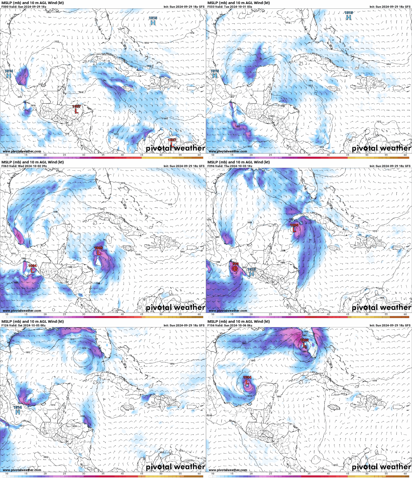
The GFS has a much different track than previous runs. How this doesn't become stronger than just a TS though:

Image
2 likes   

User avatar
toad strangler
S2K Supporter
S2K Supporter
Posts: 4543
Joined: Sun Jul 28, 2013 3:09 pm
Location: Earth
Contact:

Re: Possible development in the Western Caribbean (0/50)

#205 Postby toad strangler » Sun Sep 29, 2024 5:28 pm

Major changes on the 18z GFS
That’s like a TS Faye redux
0 likes   

Weathertracker96
Tropical Storm
Tropical Storm
Posts: 104
Joined: Mon Oct 16, 2023 3:41 pm

Re: Possible development in the Western Caribbean (0/50)

#206 Postby Weathertracker96 » Sun Sep 29, 2024 5:32 pm

gatorcane wrote:The GFS has a much different track than previous runs. How this doesn't become stronger than just a TS though:

https://i.postimg.cc/Pq8WjhM9/floop-gfs-2024092918-sfcwind-mslp-caribbean.gif

You think this could get stronger? It seems models might see unfavorable conditions.
1 likes   

User avatar
ConvergenceZone
Category 5
Category 5
Posts: 5194
Joined: Fri Jul 29, 2005 1:40 am
Location: Northern California

Re: Possible development in the Western Caribbean (0/50)

#207 Postby ConvergenceZone » Sun Sep 29, 2024 5:40 pm

Stormcenter wrote:I don’t recall the set-up being “robust” for
Helene until late.


ConvergenceZone wrote:
Hammy wrote:
Models backed off of what eventually became Helene too--I wouldn't treat this as set in stone by any stretch


Oh, I'm not saying a weak storm won't come from this, don't get me wrong, but the setup does not seem quite as robust as Helene. It's difficult for the atmosphere to produce that near perfect setup 2 times in a row. I mean even with Helene WXMAN was calling for a cat 1 landfall when it was a week away. This is probably 6 to 7 days away from landfall already, and as he said, right now it just looks like a weak low. It doesn't mean things can't change, but hopefully it will be a nice rainmaker for an area that needs the rain. I know that we never say never, just going with the odds here based on what I'm seeing so far. I'll even post a big picture of a Crow if I'm wrong and we get something big out of this. :)


I doubt it will have the favorable conditions that Helene did which is why the models liked Helene so much. The shear in the gulf was pretty much non-existent. When Helene happened everything just seemed to line up perfectly. In fact they were talking about this on our tropical update recently. But again, time will tell if I'm wrong.
3 likes   

User avatar
cycloneye
Admin
Admin
Posts: 145295
Age: 68
Joined: Thu Oct 10, 2002 10:54 am
Location: San Juan, Puerto Rico

Re: Possible development in the Western Caribbean (0/50)

#208 Postby cycloneye » Sun Sep 29, 2024 6:40 pm

8 PM:

Western Caribbean Sea and Gulf of Mexico:
A broad area of low pressure located over the western Caribbean Sea
is producing disorganized showers and thunderstorms. Environmental
conditions appear to be conducive for gradual development, and a
tropical depression could form around the middle part of this week
while the disturbance moves slowly west-northwestward. This system
is then expected to move northwestward into the Gulf of Mexico
during the latter portion of this week. Interests in the
northwestern Caribbean Sea and along the U.S. Gulf Coast should
monitor the progress of this system.
* Formation chance through 48 hours...low...near 0 percent.
* Formation chance through 7 days...medium...50 percent.
0 likes   
Visit the Caribbean-Central America Weather Thread where you can find at first post web cams,radars
and observations from Caribbean basin members Click Here

User avatar
Teban54
Category 5
Category 5
Posts: 3204
Joined: Sat May 19, 2018 1:19 pm

Re: Possible development in the Western Caribbean (0/50)

#209 Postby Teban54 » Sun Sep 29, 2024 6:51 pm

ConvergenceZone wrote:
Stormcenter wrote:I don’t recall the set-up being “robust” for
Helene until late.


ConvergenceZone wrote:

Oh, I'm not saying a weak storm won't come from this, don't get me wrong, but the setup does not seem quite as robust as Helene. It's difficult for the atmosphere to produce that near perfect setup 2 times in a row. I mean even with Helene WXMAN was calling for a cat 1 landfall when it was a week away. This is probably 6 to 7 days away from landfall already, and as he said, right now it just looks like a weak low. It doesn't mean things can't change, but hopefully it will be a nice rainmaker for an area that needs the rain. I know that we never say never, just going with the odds here based on what I'm seeing so far. I'll even post a big picture of a Crow if I'm wrong and we get something big out of this. :)


I doubt it will have the favorable conditions that Helene did which is why the models liked Helene so much. The shear in the gulf was pretty much non-existent. When Helene happened everything just seemed to line up perfectly. In fact they were talking about this on our tropical update recently. But again, time will tell if I'm wrong.

IIRC several ensemble runs for Helene, especially EPS, didn't start showing anything stronger than Cat 1 until about 3-5 days before genesis. Operational Euro didn't even develop it, which led people into thinking the best analog was Karen 2013, or a PTC that never becomes a TC before landfall.
0 likes   

User avatar
MetroMike
Category 4
Category 4
Posts: 952
Joined: Sun Aug 29, 2004 8:13 pm
Location: Tampa Bay
Contact:

Re: Possible development in the Western Caribbean (0/50)

#210 Postby MetroMike » Sun Sep 29, 2024 7:06 pm

Teban54 wrote:
ConvergenceZone wrote:
Stormcenter wrote:I don’t recall the set-up being “robust” for
Helene until late.


I doubt it will have the favorable conditions that Helene did which is why the models liked Helene so much. The shear in the gulf was pretty much non-existent. When Helene happened everything just seemed to line up perfectly. In fact they were talking about this on our tropical update recently. But again, time will tell if I'm wrong.

IIRC several ensemble runs for Helene, especially EPS, didn't start showing anything stronger than Cat 1 until about 3-5 days before genesis. Operational Euro didn't even develop it, which led people into thinking the best analog was Karen 2013, or a PTC that never becomes a TC before landfall.


I don’t understand the correlation of Karen 2013 to this hurricane. Anymore insight?
0 likes   

User avatar
ConvergenceZone
Category 5
Category 5
Posts: 5194
Joined: Fri Jul 29, 2005 1:40 am
Location: Northern California

Re: Possible development in the Western Caribbean (0/50)

#211 Postby ConvergenceZone » Sun Sep 29, 2024 7:15 pm

Teban54 wrote:
ConvergenceZone wrote:
Stormcenter wrote:I don’t recall the set-up being “robust” for
Helene until late.


I doubt it will have the favorable conditions that Helene did which is why the models liked Helene so much. The shear in the gulf was pretty much non-existent. When Helene happened everything just seemed to line up perfectly. In fact they were talking about this on our tropical update recently. But again, time will tell if I'm wrong.

IIRC several ensemble runs for Helene, especially EPS, didn't start showing anything stronger than Cat 1 until about 3-5 days before genesis. Operational Euro didn't even develop it, which led people into thinking the best analog was Karen 2013, or a PTC that never becomes a TC before landfall.


Again, let us just wait and see. I'm sure we will know before too long. :)
0 likes   

User avatar
eastcoastFL
Category 5
Category 5
Posts: 3901
Age: 43
Joined: Thu Apr 12, 2007 12:29 pm
Location: Palm City, FL

Re: Possible development in the Western Caribbean (0/50)

#212 Postby eastcoastFL » Sun Sep 29, 2024 7:28 pm

ConvergenceZone wrote:
Teban54 wrote:
ConvergenceZone wrote:
I doubt it will have the favorable conditions that Helene did which is why the models liked Helene so much. The shear in the gulf was pretty much non-existent. When Helene happened everything just seemed to line up perfectly. In fact they were talking about this on our tropical update recently. But again, time will tell if I'm wrong.

IIRC several ensemble runs for Helene, especially EPS, didn't start showing anything stronger than Cat 1 until about 3-5 days before genesis. Operational Euro didn't even develop it, which led people into thinking the best analog was Karen 2013, or a PTC that never becomes a TC before landfall.


Again, let us just wait and see. I'm sure we will know before too long. :)


Shear is pretty rough right now in W. Carib but we all know how fast that can change. But it becomes less of a factor as any potential system approaches the gulf.


Image
0 likes   
Personal Forecast Disclaimer:
The posts in this forum are NOT official forecast and should not be used as such. They are just the opinion of the poster and may or may not be backed by sound meteorological data. They are NOT endorsed by any professional institution or storm2k.org. For official information, please refer to the NHC and NWS products.

psyclone
S2K Supporter
S2K Supporter
Posts: 4762
Joined: Wed Aug 24, 2005 9:04 pm
Location: palm harbor fl

Re: Possible development in the Western Caribbean (0/50)

#213 Postby psyclone » Sun Sep 29, 2024 7:44 pm

There's a pretty good signal for heavy rain over Florida at a minimum. Anything beyond that fits into the unknowable category at this point. I'd disregard both the hype squad and the professional downcast squad at this point and wait for clarity...which will take awhile...pretty much just like every potential system.
4 likes   

User avatar
ConvergenceZone
Category 5
Category 5
Posts: 5194
Joined: Fri Jul 29, 2005 1:40 am
Location: Northern California

Re: Possible development in the Western Caribbean (0/50)

#214 Postby ConvergenceZone » Sun Sep 29, 2024 7:52 pm

psyclone wrote:There's a pretty good signal for heavy rain over Florida at a minimum. Anything beyond that fits into the unknowable category at this point. I'd disregard both the hype squad and the professional downcast squad at this point and wait for clarity...which will take awhile...pretty much just like every potential system.


Yea I do think Florida can get some rains from this. Let's just hope the rains move in and out fairly quickly if they do come. They need a break.
0 likes   

User avatar
HurricaneBelle
S2K Supporter
S2K Supporter
Posts: 1179
Joined: Sun Aug 27, 2006 6:12 pm
Location: Clearwater, FL

Re: Possible development in the Western Caribbean (0/50)

#215 Postby HurricaneBelle » Sun Sep 29, 2024 8:03 pm

psyclone wrote:There's a pretty good signal for heavy rain over Florida at a minimum. Anything beyond that fits into the unknowable category at this point. I'd disregard both the hype squad and the professional downcast squad at this point and wait for clarity...which will take awhile...pretty much just like every potential system.


Speaking of rains, interestingly we didn't get very much from Helene in Pinellas (I recorded about 1.5 inch total at my house from Wed night-Fri AM) so for those of us not subject to surge Debby was worse (had some water intrusion myself). Of course Helene was catastrophic for those who were, and I'd rather have the water intrusion I dealt with than for all those people to suffer on the coast.

For this one I could do without the rain and the surge.
0 likes   

User avatar
Hammy
Category 5
Category 5
Posts: 5849
Age: 41
Joined: Fri May 25, 2012 5:25 pm
Contact:

Re: Possible development in the Western Caribbean (0/50)

#216 Postby Hammy » Sun Sep 29, 2024 8:03 pm

MetroMike wrote:
Teban54 wrote:
ConvergenceZone wrote:
I doubt it will have the favorable conditions that Helene did which is why the models liked Helene so much. The shear in the gulf was pretty much non-existent. When Helene happened everything just seemed to line up perfectly. In fact they were talking about this on our tropical update recently. But again, time will tell if I'm wrong.

IIRC several ensemble runs for Helene, especially EPS, didn't start showing anything stronger than Cat 1 until about 3-5 days before genesis. Operational Euro didn't even develop it, which led people into thinking the best analog was Karen 2013, or a PTC that never becomes a TC before landfall.


I don’t understand the correlation of Karen 2013 to this hurricane. Anymore insight?


Some posts were making comparisons between future-Helene and Karen, and seemingly treating the models that failed to develop it/briefly developed it as set in stone.
2 likes   
The above post is not official and should not be used as such. It is the opinion of the poster and may or may not be backed by sound meteorological data. It is not endorsed by any professional institution or storm2k.org. For official information, please refer to the NHC and NWS products.

User avatar
wzrgirl1
S2K Supporter
S2K Supporter
Posts: 1325
Joined: Sat Sep 04, 2004 6:44 am
Location: Pembroke Pines, Florida

Re: Possible development in the Western Caribbean (0/50)

#217 Postby wzrgirl1 » Sun Sep 29, 2024 8:13 pm

The Weather Channel was talking as if it was a definite this afternoon and said that" it would be headed to Florida." One of the newscasters said "we don't want to scare anyone but it looks as if there will be nothing preventing this from forming and doing a sharp curve toward Florida." They showed the American model which had it making landfall just south of Tampa. Just sayin.....

I thought it was a bit premature.
0 likes   

BIFF_THE_UNRULY
Tropical Storm
Tropical Storm
Posts: 143
Joined: Fri Jun 28, 2024 2:12 pm

Re: Possible development in the Western Caribbean (0/50)

#218 Postby BIFF_THE_UNRULY » Sun Sep 29, 2024 8:19 pm

ConvergenceZone wrote:
psyclone wrote:There's a pretty good signal for heavy rain over Florida at a minimum. Anything beyond that fits into the unknowable category at this point. I'd disregard both the hype squad and the professional downcast squad at this point and wait for clarity...which will take awhile...pretty much just like every potential system.


Yea I do think Florida can get some rains from this. Let's just hope the rains move in and out fairly quickly if they do come. They need a break.


Would tend to disagree. Helene was a very poor rainmaker for us...the images, the water, the flooding you see from Florida. It was all Storm Surge. We probably need more rain if anything but I am not one to Wishcast here and just hope whatever it is it is over and done with quick because this guy is ready for cool Fall weather
Last edited by BIFF_THE_UNRULY on Sun Sep 29, 2024 8:20 pm, edited 1 time in total.
2 likes   

User avatar
eastcoastFL
Category 5
Category 5
Posts: 3901
Age: 43
Joined: Thu Apr 12, 2007 12:29 pm
Location: Palm City, FL

Re: Possible development in the Western Caribbean (0/50)

#219 Postby eastcoastFL » Sun Sep 29, 2024 8:20 pm

ICON looks like it develops something in the BOC but the run ends shortly after. Euro has something that pops up in the gulf an heads towards Tampa. Looks like a weak TS?
0 likes   
Personal Forecast Disclaimer:
The posts in this forum are NOT official forecast and should not be used as such. They are just the opinion of the poster and may or may not be backed by sound meteorological data. They are NOT endorsed by any professional institution or storm2k.org. For official information, please refer to the NHC and NWS products.

User avatar
eastcoastFL
Category 5
Category 5
Posts: 3901
Age: 43
Joined: Thu Apr 12, 2007 12:29 pm
Location: Palm City, FL

Re: Possible development in the Western Caribbean (0/50)

#220 Postby eastcoastFL » Sun Sep 29, 2024 8:21 pm

BIFF_THE_UNRULY wrote:
ConvergenceZone wrote:
psyclone wrote:There's a pretty good signal for heavy rain over Florida at a minimum. Anything beyond that fits into the unknowable category at this point. I'd disregard both the hype squad and the professional downcast squad at this point and wait for clarity...which will take awhile...pretty much just like every potential system.


Yea I do think Florida can get some rains from this. Let's just hope the rains move in and out fairly quickly if they do come. They need a break.


Would tend to disagree. Helene was a very poor rainmaker for us. We probably need more rain.


I guess that would depend on where exactly you are located.
0 likes   
Personal Forecast Disclaimer:
The posts in this forum are NOT official forecast and should not be used as such. They are just the opinion of the poster and may or may not be backed by sound meteorological data. They are NOT endorsed by any professional institution or storm2k.org. For official information, please refer to the NHC and NWS products.


Return to “Talkin' Tropics”

Who is online

Users browsing this forum: gib, HurricaneFan, RomP and 29 guests