2024 Indicators: SST's, MSLP, Shear, SAL, Steering, Instability (Day 16+ Climate Models)

This is the general tropical discussion area. Anyone can take their shot at predicting a storms path.

Moderator: S2k Moderators

Forum rules

The posts in this forum are NOT official forecasts and should not be used as such. They are just the opinion of the poster and may or may not be backed by sound meteorological data. They are NOT endorsed by any professional institution or STORM2K. For official information, please refer to products from the National Hurricane Center and National Weather Service.

Help Support Storm2K
Message
Author
User avatar
toad strangler
S2K Supporter
S2K Supporter
Posts: 4543
Joined: Sun Jul 28, 2013 3:09 pm
Location: Earth
Contact:

Re: 2024 Indicators: SST's, MSLP, Shear, SAL, Steering, Instability (Day 16+ Climate Models)

#2521 Postby toad strangler » Fri Sep 27, 2024 12:00 pm

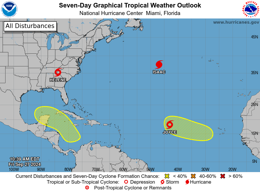
Teban54 wrote:Is September 27 the new September 10?

  • Helene is still causing flooding problems after an impressive Cat 4 landfall
  • Isaac strengthened into a high-latitude hurricane, and may even have a chance at Cat 2 (however small)
  • Joyce has formed, marking the first time in 2024 with three concurrent TCs
  • Two more lemons, with a possible Helene redux and a possible MDR storm in October

https://i.postimg.cc/QxZMXFfQ/two-atl-7d0.png


Anomalies are always fun to talk about. This year it was Beryl early, the mid August to peak season drought, And now a flurry of activity as if this now was the last week of August into 9/10 climatological peak. Storm count forecast will bust and ACE projections will likely underwhelm. But real impacts have already overwhelmed, and we haven’t even hit October yet.
1 likes   

User avatar
cycloneye
Admin
Admin
Posts: 145277
Age: 68
Joined: Thu Oct 10, 2002 10:54 am
Location: San Juan, Puerto Rico

Re: 2024 Indicators: SST's, MSLP, Shear, SAL, Steering, Instability (Day 16+ Climate Models)

#2522 Postby cycloneye » Sat Sep 28, 2024 8:01 pm

A look at the 2024 season so far. Notice that Beryl and Helene took the same track just before Yucatán.

Image
4 likes   
Visit the Caribbean-Central America Weather Thread where you can find at first post web cams,radars
and observations from Caribbean basin members Click Here

User avatar
Hurricane2022
Category 5
Category 5
Posts: 1541
Joined: Tue Aug 23, 2022 11:38 pm
Location: Araçatuba, Brazil

Re: 2024 Indicators: SST's, MSLP, Shear, SAL, Steering, Instability (Day 16+ Climate Models)

#2523 Postby Hurricane2022 » Sat Sep 28, 2024 8:12 pm

cycloneye wrote:A look at the 2024 season so far. Notice that Beryl and Helene took the same track just before Yucatán.

https://i.imgur.com/oeK2KEZ.png

Initially I was expecting to see this map in Early August, not in late September :lol: but anyway... Thank god this image is from September 28 and not August 8 :double:
2 likes   
Sorry for the bad English sometimes...!
For reliable and detailed information for any meteorological phenomenon, please consult the National Hurricane Center, Joint Typhoon Warning Center , or your local Meteo Center.

--------

Una cvm Christo, pro Christo, et in Christo. Sit nomen Domini benedictvm.

User avatar
Hammy
Category 5
Category 5
Posts: 5849
Age: 41
Joined: Fri May 25, 2012 5:25 pm
Contact:

Re: 2024 Indicators: SST's, MSLP, Shear, SAL, Steering, Instability (Day 16+ Climate Models)

#2524 Postby Hammy » Sun Sep 29, 2024 1:07 am

Interesting thing to note, I believe this will be the first time since 2015 that we've gone the entire month of September without an MDR-originating hurricane
1 likes   
The above post is not official and should not be used as such. It is the opinion of the poster and may or may not be backed by sound meteorological data. It is not endorsed by any professional institution or storm2k.org. For official information, please refer to the NHC and NWS products.

User avatar
aspen
Category 5
Category 5
Posts: 8818
Joined: Sat Oct 12, 2019 7:10 pm
Location: Connecticut, USA

Re: 2024 Indicators: SST's, MSLP, Shear, SAL, Steering, Instability (Day 16+ Climate Models)

#2525 Postby aspen » Sun Sep 29, 2024 8:14 am

Looks like the predictions of a late September peak/switch flip and a very late MDR season are verifying. We might actually hit 15 NS and 100+ ACE at this rate; after the late August to early September slowdown, it was looking possible this season wouldn’t break 10 NS and 100 ACE.
6 likes   
Irene '11 Sandy '12 Hermine '16 5/15/2018 Derecho Fay '20 Isaias '20 Elsa '21 Henri '21 Ida '21

I am only a meteorology enthusiast who knows a decent amount about tropical cyclones. Look to the professional mets, the NHC, or your local weather office for the best information.

tolakram
Admin
Admin
Posts: 20009
Age: 62
Joined: Sun Aug 27, 2006 8:23 pm
Location: Florence, KY (name is Mark)

Re: 2024 Indicators: SST's, MSLP, Shear, SAL, Steering, Instability (Day 16+ Climate Models)

#2526 Postby tolakram » Sun Sep 29, 2024 10:38 am

aspen wrote:Looks like the predictions of a late September peak/switch flip and a very late MDR season are verifying. We might actually hit 15 NS and 100+ ACE at this rate; after the late August to early September slowdown, it was looking possible this season wouldn’t break 10 NS and 100 ACE.


I'm not so sure, but I'm also not sure it matters after Helene. The message was for a bad season, communicated in storm count. The reality was one of the largest disasters in recent memory from a single storm.
6 likes   
M a r k
- - - - -
Join us in chat: Storm2K Chatroom Invite. Android and IOS apps also available.

The posts in this forum are NOT official forecasts and should not be used as such. Posts are NOT endorsed by any professional institution or STORM2K.org. For official information and forecasts, please refer to NHC and NWS products.

User avatar
kevin
Category 5
Category 5
Posts: 2586
Age: 26
Joined: Wed Aug 28, 2019 4:35 am

Re: 2024 Indicators: SST's, MSLP, Shear, SAL, Steering, Instability (Day 16+ Climate Models)

#2527 Postby kevin » Mon Sep 30, 2024 4:05 am

A TD expected to become an MDR MH, another wave behind it with similar long-tracker MH potential and perhaps a risk of not going OTS. Then another GOM/WCar disturbance which is always a wild card. And two other active systems about to leave the scene. Looks more like Sept 1 than Sept 30. We could still be in for a long season.

Image
6 likes   

User avatar
Blown Away
S2K Supporter
S2K Supporter
Posts: 10145
Joined: Wed May 26, 2004 6:17 am

Re: 2024 Indicators: SST's, MSLP, Shear, SAL, Steering, Instability (Day 16+ Climate Models)

#2528 Postby Blown Away » Mon Sep 30, 2024 6:47 am

CV hurricanes very rarely make it across the Atlantic anymore to affect land… All this preseason talk of +NAO and stronger BH, etc… Is it just pure coincidence or is there something changing in the atmosphere???
1 likes   
Hurricane Eye Experience: David 79, Irene 99, Frances 04, Jeanne 04, Wilma 05... EYE COMING MY WAY IN 2024…
Hurricane Brush Experience: Andrew 92, Erin 95, Floyd 99, Matthew 16, Irma 17, Ian 22, Nicole 22…

Cachondo23
Tropical Depression
Tropical Depression
Posts: 75
Joined: Wed May 25, 2022 5:56 am

Re: 2024 Indicators: SST's, MSLP, Shear, SAL, Steering, Instability (Day 16+ Climate Models)

#2529 Postby Cachondo23 » Mon Sep 30, 2024 6:54 am

Blown Away wrote:CV hurricanes very rarely make it across the Atlantic anymore to affect land… All this preseason talk of +NAO and stronger BH, etc… Is it just pure coincidence or is there something changing in the atmosphere???

Well, is Beryl not consider a CV hurricane has it almost form south of those islands and hit Windwards Islands among other places?

I do agree with you that in the past years CV hurricanes that have affected land have been very rare. Nothing like 2017 we haven't seen in a while.
3 likes   

User avatar
Zonacane
Category 1
Category 1
Posts: 361
Joined: Tue Aug 03, 2021 2:23 pm

Re: 2024 Indicators: SST's, MSLP, Shear, SAL, Steering, Instability (Day 16+ Climate Models)

#2530 Postby Zonacane » Mon Sep 30, 2024 9:24 am

Blown Away wrote:CV hurricanes very rarely make it across the Atlantic anymore to affect land… All this preseason talk of +NAO and stronger BH, etc… Is it just pure coincidence or is there something changing in the atmosphere???

WE HAD A CATEGORY 5 CV THIS YEAR THAT MADE LANDFALL IN TEXAS
6 likes   

User avatar
Kazmit
Category 5
Category 5
Posts: 2124
Age: 22
Joined: Mon Jul 25, 2016 8:49 am
Location: Williamsburg, VA / Bermuda

Re: 2024 Indicators: SST's, MSLP, Shear, SAL, Steering, Instability (Day 16+ Climate Models)

#2531 Postby Kazmit » Mon Sep 30, 2024 9:35 am

Blown Away wrote:CV hurricanes very rarely make it across the Atlantic anymore to affect land… All this preseason talk of +NAO and stronger BH, etc… Is it just pure coincidence or is there something changing in the atmosphere???

It's rare for strong hurricanes to traverse the whole MDR without getting picked up by a trough anyway. Now that it's practically October, it's extra rare.
2 likes   
Igor 2010, Sandy 2012, Fay 2014, Gonzalo 2014, Joaquin 2015, Nicole 2016, Humberto 2019

I am only a tropical weather enthusiast. My predictions are not official and may or may not be backed by sound meteorological data. For official information, please refer to the NHC and NWS products.

User avatar
weeniepatrol
Category 5
Category 5
Posts: 1273
Joined: Sat Aug 22, 2020 5:30 pm
Location: WA State

Re: 2024 Indicators: SST's, MSLP, Shear, SAL, Steering, Instability (Day 16+ Climate Models)

#2532 Postby weeniepatrol » Mon Sep 30, 2024 4:43 pm

Image
5 likes   

User avatar
WaveBreaking
Category 2
Category 2
Posts: 578
Joined: Sun Jun 30, 2024 11:33 am
Location: US

Re: 2024 Indicators: SST's, MSLP, Shear, SAL, Steering, Instability (Day 16+ Climate Models)

#2533 Postby WaveBreaking » Mon Sep 30, 2024 4:52 pm


This is almost comical. It’s like the Atlantic heard people talking about a below-average season and took it personally.
6 likes   
I am NOT a professional meteorologist, so take all of my posts with a grain of salt. My opinions are mine and mine alone.

User avatar
Category5Kaiju
Category 5
Category 5
Posts: 4095
Joined: Thu Dec 24, 2020 12:45 pm
Location: Seattle

Re: 2024 Indicators: SST's, MSLP, Shear, SAL, Steering, Instability (Day 16+ Climate Models)

#2534 Postby Category5Kaiju » Mon Sep 30, 2024 5:01 pm

If a future season ever sees stability problems in August and early September despite a -ENSO state, you can surely bet that 2024 will be used as an example of how that doesn't mean it will be the same in late September onward :lol: :lol:
8 likes   
Unless explicitly stated, all info in my posts is based on my own opinions and observations. Tropical storms and hurricanes can be extremely dangerous. Do not think you can beat Mother Nature. Refer to an accredited weather research agency or meteorologist if you need to make serious decisions regarding an approaching storm.

User avatar
Teban54
Category 5
Category 5
Posts: 3204
Joined: Sat May 19, 2018 1:19 pm

Re: 2024 Indicators: SST's, MSLP, Shear, SAL, Steering, Instability (Day 16+ Climate Models)

#2535 Postby Teban54 » Mon Sep 30, 2024 6:53 pm

Category5Kaiju wrote:If a future season ever sees stability problems in August and early September despite a -ENSO state, you can surely bet that 2024 will be used as an example of how that doesn't mean it will be the same in late September onward :lol: :lol:

I mean, people used 2022 to argue for a delayed peak in 2024 just a few weeks earlier, and that wasn't enough to convince others who had firmly believed that the season was effectively over.
4 likes   


User avatar
Teban54
Category 5
Category 5
Posts: 3204
Joined: Sat May 19, 2018 1:19 pm

Re: 2024 Indicators: SST's, MSLP, Shear, SAL, Steering, Instability (Day 16+ Climate Models)

#2537 Postby Teban54 » Wed Oct 02, 2024 10:08 pm

From Phil Klotzbach's tweet earlier. While not at the forecast 23/12/6 levels, the season is now back to above average YTD in NS, H and MH counts compared to the "inflated" 1991-2020 climo.

Image
3 likes   

User avatar
kevin
Category 5
Category 5
Posts: 2586
Age: 26
Joined: Wed Aug 28, 2019 4:35 am

Re: 2024 Indicators: SST's, MSLP, Shear, SAL, Steering, Instability (Day 16+ Climate Models)

#2538 Postby kevin » Thu Oct 03, 2024 4:30 pm

With Kirk becoming a cat 4, the 2024 season now has 3 cat 4/5 hurricanes. I usually only look at MH and regular hurricane numbers. But I also decided to check out the statistics for cat 4/5 hurricanes only. If you do so, these are the seasons with the most cat 4 and 5 hurricanes. With 3 cat 4/5 hurricanes, 2024 now belongs to the upper ~10% years in the database. Only 12 seasons have had 4 cat 4/5 hurricanes or more, 1964 and 2008 being the only of those years not reaching hyperactivity. Will be interesting to see where 2024 will fall at the end of the season.

- 5 -
2020
2005
1999
1961
1933

- 4 -
2017
2010
2008
2004
1964
1932
1926

- 3 -
2024
2023
2019
1995
1988
1958
1955
1950
1935
6 likes   

jlauderdal
S2K Supporter
S2K Supporter
Posts: 7182
Joined: Wed May 19, 2004 5:46 am
Location: NE Fort Lauderdale
Contact:

Re: RE: Re: 2024 Indicators: SST's, MSLP, Shear, SAL, Steering, Instability (Day 16+ Climate Models)

#2539 Postby jlauderdal » Thu Oct 03, 2024 4:37 pm

kevin wrote:With Kirk becoming a cat 4, the 2024 season now has 3 cat 4/5 hurricanes. I usually only look at MH and regular hurricane numbers. But I also decided to check out the statistics for cat 4/5 hurricanes only. If you do so, these are the seasons with the most cat 4 and 5 hurricanes. With 3 cat 4/5 hurricanes, 2024 now belongs to the upper ~10% years in the database. Only 12 seasons have had 4 cat 4/5 hurricanes or more, 1964 and 2008 being the only of those years not reaching hyperactivity. Will be interesting to see where 2024 will fall at the end of the season.

- 5 -
2020
2005
1999
1961
1933

- 4 -
2017
2010
2008
2004
1964
1932
1926

- 3 -
2024
2023
2019
1995
1988
1958
1955
1950
1935
Quality and we are seeing quantity now, a very strange season that still has work to do.
6 likes   

User avatar
Category5Kaiju
Category 5
Category 5
Posts: 4095
Joined: Thu Dec 24, 2020 12:45 pm
Location: Seattle

Re: 2024 Indicators: SST's, MSLP, Shear, SAL, Steering, Instability (Day 16+ Climate Models)

#2540 Postby Category5Kaiju » Fri Oct 04, 2024 6:58 am

In hindsight, maybe Beryl indeed was an indicator of a busy season, as opposed to being a stray that appeared out of nowhere for no reason? :lol:

The same abnormally warm waters that fueled Beryl seem to be helping fuel a very late Cape Verde season with two significant hurricanes. And there's no telling what these warm waters will help fuel once we get into late October and November, when activity shifts to the Caribbean. Or....maybe we do get a November MDR major? Who knows?
7 likes   
Unless explicitly stated, all info in my posts is based on my own opinions and observations. Tropical storms and hurricanes can be extremely dangerous. Do not think you can beat Mother Nature. Refer to an accredited weather research agency or meteorologist if you need to make serious decisions regarding an approaching storm.


Return to “Talkin' Tropics”

Who is online

Users browsing this forum: Stratton23, sweetpea and 32 guests