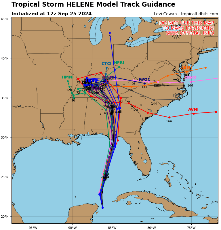
ATL: HELENE - Models

Moderator: S2k Moderators

Message
Author
User avatar
gulfcoastdave
Tropical Storm
Tropical Storm
Posts: 100
Joined: Mon Jun 13, 2005 1:33 pm
Location: Milton,Fl
Contact:

Re: ATL: HELENE - Models

#721 Postby gulfcoastdave » Wed Sep 25, 2024 10:15 am

MetsIslesNoles wrote:
TallyTracker wrote:I’m leaving Tallahassee shortly. Definitely is the right decision. Those are terrible runs for this area!
Be safe. I'm riding it out.


I'm over near pensacola but my daughter lives in Tally and is leaving after work this afternoon.
Many business are staying open in tally
If the path is correct and tally takes a hit ,power will be out for awhile due to all the big trees
2 likes   

WacoWx
Category 2
Category 2
Posts: 664
Joined: Mon Dec 28, 2009 4:14 pm
Location: NOT Waco, TX ----> Dallas, TX

Re: ATL: HELENE - Models

#722 Postby WacoWx » Wed Sep 25, 2024 10:17 am

I think we should say Tally more often.
1 likes   

tolakram
Admin
Admin
Posts: 20009
Age: 62
Joined: Sun Aug 27, 2006 8:23 pm
Location: Florence, KY (name is Mark)

Re: ATL: HELENE - Models

#723 Postby tolakram » Wed Sep 25, 2024 10:26 am

There is a local thread FYI, let's keep models models.

https://www.storm2k.org/phpbb2/viewtopi ... 9&t=124348
1 likes   
M a r k
- - - - -
Join us in chat: Storm2K Chatroom Invite. Android and IOS apps also available.

The posts in this forum are NOT official forecasts and should not be used as such. Posts are NOT endorsed by any professional institution or STORM2K.org. For official information and forecasts, please refer to NHC and NWS products.

User avatar
Steve
S2K Supporter
S2K Supporter
Posts: 9620
Joined: Sat Apr 05, 2003 11:41 pm
Location: Not a state-caster

Re: ATL: HELENE - Models

#724 Postby Steve » Wed Sep 25, 2024 10:33 am

Going back 4 ICON runs it's a bit farther west coming in but a hair farther east than the consensus. I'm guessing Helene is going to hit just east of Apalachicola somewhere in the 940's or 950's. FV3 Hires hits right at the center of the bay @ 968. I don't think that's a bad forecast for a mesoscale. Nam 12km is 952 also west-central part of the bay.
0 likes   

User avatar
ThunderForce
Tropical Storm
Tropical Storm
Posts: 208
Age: 25
Joined: Tue Sep 27, 2022 6:20 pm
Location: Calhoun County, Florida

Re: ATL: HELENE - Models

#725 Postby ThunderForce » Wed Sep 25, 2024 10:39 am

So, this is a weird question, but does anyone know why the NHC's cone and the model track guidance on Tropical Tidbits are so much further west in comparison to the actual models? The latter shows many of the models (and therefore TVCN) to the left of their operational runs, which is pretty confusing.
Image
2 likes   
Please refer to the NWS, NHC, SPC or a professional meteorologist for information and decision making during storms.

tolakram
Admin
Admin
Posts: 20009
Age: 62
Joined: Sun Aug 27, 2006 8:23 pm
Location: Florence, KY (name is Mark)

Re: ATL: HELENE - Models

#726 Postby tolakram » Wed Sep 25, 2024 10:45 am

ThunderForce wrote:So, this is a weird question, but does anyone know why the NHC's cone and the model track guidance on Tropical Tidbits are so much further west in comparison to the actual models? The latter shows many of the models (and therefore TVCN) to the left of their operational runs, which is pretty confusing.
https://i.postimg.cc/VNf0ydSb/09-L-tracks-latest.png


Mainly because not all of those models have the same skill. They use skill based methods to determine track, which is why they are usually more accurate than any individual model. There are exceptions, of course, but not many. They also tend to move the line slowly if models start moving around, as they sometimes tend to do. It's not perfect, which is why the cone is more important than the line. Remember the cone is actually a circle around each forecast point that represents historical error percentages at that time point. These circles are resized every year based on past performance.
1 likes   
M a r k
- - - - -
Join us in chat: Storm2K Chatroom Invite. Android and IOS apps also available.

The posts in this forum are NOT official forecasts and should not be used as such. Posts are NOT endorsed by any professional institution or STORM2K.org. For official information and forecasts, please refer to NHC and NWS products.

BIFF_THE_UNRULY
Tropical Storm
Tropical Storm
Posts: 143
Joined: Fri Jun 28, 2024 2:12 pm

Re: ATL: HELENE - Models

#727 Postby BIFF_THE_UNRULY » Wed Sep 25, 2024 10:51 am

breathing much easier in Tampa right now. Looks like our winning streak will continue.
8 likes   

shah83
Category 1
Category 1
Posts: 302
Joined: Sun Jul 31, 2016 4:55 pm

Re: ATL: HELENE - Models

#728 Postby shah83 » Wed Sep 25, 2024 10:52 am

12z GFS is thoroughly scary. It's not as disrupted by the front as earlier models are, and it has an absolutely enormous hurricane windfield approaching landfall.
2 likes   

tolakram
Admin
Admin
Posts: 20009
Age: 62
Joined: Sun Aug 27, 2006 8:23 pm
Location: Florence, KY (name is Mark)

Re: ATL: HELENE - Models

#729 Postby tolakram » Wed Sep 25, 2024 10:57 am

12Z GFS
Image

12Z ICON
Image
0 likes   
M a r k
- - - - -
Join us in chat: Storm2K Chatroom Invite. Android and IOS apps also available.

The posts in this forum are NOT official forecasts and should not be used as such. Posts are NOT endorsed by any professional institution or STORM2K.org. For official information and forecasts, please refer to NHC and NWS products.

tolakram
Admin
Admin
Posts: 20009
Age: 62
Joined: Sun Aug 27, 2006 8:23 pm
Location: Florence, KY (name is Mark)

Re: ATL: HELENE - Models

#730 Postby tolakram » Wed Sep 25, 2024 11:00 am

GFS trend
Image

ICON trend
Image
1 likes   
M a r k
- - - - -
Join us in chat: Storm2K Chatroom Invite. Android and IOS apps also available.

The posts in this forum are NOT official forecasts and should not be used as such. Posts are NOT endorsed by any professional institution or STORM2K.org. For official information and forecasts, please refer to NHC and NWS products.

User avatar
Stellar
Tropical Low
Tropical Low
Posts: 17
Joined: Tue Sep 19, 2017 2:38 pm
Location: Virginia Beach, VA

Re: ATL: HELENE - Models

#731 Postby Stellar » Wed Sep 25, 2024 11:02 am

The flooding in Atlanta and Charlotte will be of concern....ground there is already saturated with rain today and tomorrow.
1 likes   

shah83
Category 1
Category 1
Posts: 302
Joined: Sun Jul 31, 2016 4:55 pm

Re: ATL: HELENE - Models

#732 Postby shah83 » Wed Sep 25, 2024 11:02 am

I also kind of suspect that we will have wave issues, a la Ivan, on top of that surge.
0 likes   

User avatar
ScottNAtlanta
Category 5
Category 5
Posts: 2367
Joined: Sat May 25, 2013 3:11 pm
Location: Atlanta, GA

Re: ATL: HELENE - Models

#733 Postby ScottNAtlanta » Wed Sep 25, 2024 11:52 am

Stellar wrote:The flooding in Atlanta and Charlotte will be of concern....ground there is already saturated with rain today and tomorrow.

The track will be crucial for that. If it is west of Atlanta it will be much worse that if it passes east. As it is, looks like it might go right over us. Actually, it has been very dry in Atlanta, but the frontal passage will drop from 2 to 3 inches of rain before Helene even gets here.
0 likes   
The posts in this forum are NOT official forecast and should not be used as such. They are just the opinion of the poster and may or may not be backed by sound meteorological data. They are NOT endorsed by any professional institution or storm2k.org. For official information, please refer to the NHC and NWS products.

User avatar
SouthFLTropics
Category 5
Category 5
Posts: 4236
Age: 50
Joined: Thu Aug 14, 2003 8:04 am
Location: Port St. Lucie, Florida

Re: ATL: HELENE - Models

#734 Postby SouthFLTropics » Wed Sep 25, 2024 12:03 pm

HAFS-A coming in with a pretty sizeable shift right at 33 hours. Hope that's not the start of a trend. Keep paying attention for any of you that said Tampa was in the clear.

EDIT - Actually it may be an optical illusion with the model but it sure does appear to shift right. It might just be increased convection.
2 likes   
Fourth Generation Florida Native

Personal Storm History: David 79, Andrew 92, Erin 95, Floyd 99, Irene 99, Frances 04, Jeanne 04, Wilma 05, Matthew 16, Irma 17, Ian 22, Nicole 22, Milton 24

User avatar
aspen
Category 5
Category 5
Posts: 8818
Joined: Sat Oct 12, 2019 7:10 pm
Location: Connecticut, USA

Re: ATL: HELENE - Models

#735 Postby aspen » Wed Sep 25, 2024 12:10 pm

HWRF and HAFS-A/B all show Helene mixing out the dry slot by late this afternoon or early evening, with a compact, healthy eyewall forming overnight as RI commences. All show a high-end Cat 4 or a Cat 5.
0 likes   
Irene '11 Sandy '12 Hermine '16 5/15/2018 Derecho Fay '20 Isaias '20 Elsa '21 Henri '21 Ida '21

I am only a meteorology enthusiast who knows a decent amount about tropical cyclones. Look to the professional mets, the NHC, or your local weather office for the best information.

User avatar
Bocadude85
Category 5
Category 5
Posts: 2991
Age: 38
Joined: Mon Apr 18, 2005 2:20 pm
Location: Honolulu,Hi

Re: ATL: HELENE - Models

#736 Postby Bocadude85 » Wed Sep 25, 2024 12:15 pm

SouthFLTropics wrote:HAFS-A coming in with a pretty sizeable shift right at 33 hours. Hope that's not the start of a trend. Keep paying attention for any of you that said Tampa was in the clear.

EDIT - Actually it may be an optical illusion with the model but it sure does appear to shift right. It might just be increased convection.


Definitely a hair east of the 6z.. the closer to the Florida west central coast the higher the surge I would imagine.
0 likes   

tolakram
Admin
Admin
Posts: 20009
Age: 62
Joined: Sun Aug 27, 2006 8:23 pm
Location: Florence, KY (name is Mark)

Re: ATL: HELENE - Models

#737 Postby tolakram » Wed Sep 25, 2024 12:18 pm

Image

Image

Image

Image
3 likes   
M a r k
- - - - -
Join us in chat: Storm2K Chatroom Invite. Android and IOS apps also available.

The posts in this forum are NOT official forecasts and should not be used as such. Posts are NOT endorsed by any professional institution or STORM2K.org. For official information and forecasts, please refer to NHC and NWS products.

BIFF_THE_UNRULY
Tropical Storm
Tropical Storm
Posts: 143
Joined: Fri Jun 28, 2024 2:12 pm

Re: ATL: HELENE - Models

#738 Postby BIFF_THE_UNRULY » Wed Sep 25, 2024 12:52 pm

WacoWx wrote:I think we should say Tally more often.


When I lived there we called it Tally Wally. It was awhile ago.

Back when you could get a Pepperoni Pizza for $5. Locals in Tallahassee call a pepperoni pizza a "Hot Carl" for some reason. Great place

You just walk up to the counter and order it.
0 likes   

User avatar
Emmett_Brown
Category 5
Category 5
Posts: 1432
Joined: Wed Aug 24, 2005 9:10 pm
Location: Sarasota FL

Re: ATL: HELENE - Models

#739 Postby Emmett_Brown » Wed Sep 25, 2024 12:54 pm

12Z GEFS has a couple strong members that are east near Cedar Key. But the ensemble mean is pretty much unchanged from 6Z
0 likes   

BIFF_THE_UNRULY
Tropical Storm
Tropical Storm
Posts: 143
Joined: Fri Jun 28, 2024 2:12 pm

Re: ATL: HELENE - Models

#740 Postby BIFF_THE_UNRULY » Wed Sep 25, 2024 12:54 pm

Stellar wrote:The flooding in Atlanta and Charlotte will be of concern....ground there is already saturated with rain today and tomorrow.


Given the storms speed and projected strength. Atlanta and swathes of Georgia could get some really serouis weather they are not designed to get. Reminds me of Opal somewhat. 100mph winds hundreds of miles inward
0 likes   


Return to “2024”

Who is online

Users browsing this forum: No registered users and 0 guests