ATL: HELENE - Models
Moderator: S2k Moderators

Re: ATL: NINE - Models
Oddly not intensifying though yet. Still 986 several hours later at 51H
Last edited by Steve on Mon Sep 23, 2024 10:56 pm, edited 1 time in total.
0 likes

Re: ATL: NINE - Models
0 likes
Re: ATL: NINE - Models
Another steinhatchee landfall on 0z, same intensity even as 18z. No real change on the GFS. High end cat 2 at landfall, pushing a 3.

Last edited by BobHarlem on Mon Sep 23, 2024 10:58 pm, edited 2 times in total.
1 likes
-
Nederlander
- S2K Supporter

- Posts: 1259
- Joined: Sat Jul 19, 2008 4:28 pm
- Location: Conroe, TX
Re: ATL: NINE - Models
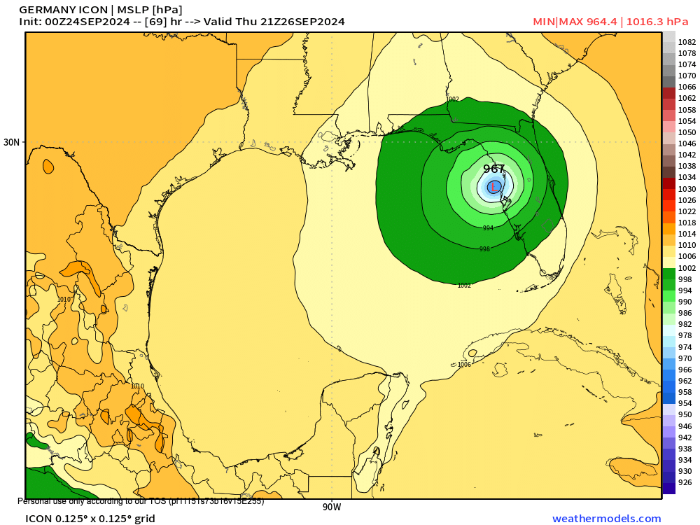
CycloysisNegative wrote:MetroMike wrote:lsuhurricane wrote:Steve,
Its actually 964 mb on landfall per the stamp on Weathermodels
https://i.postimg.cc/j5p8Ds6m/13-km-ICON-MSLP-MSLP-69-1.png
Good thing the ICON model is not one of the main models
that are taken more seriously.
It is taken seriously. It’s done very well with Gulf systems this year.
Yes, it has actually led the pack this year. Did well last year too.
0 likes

Re: ATL: NINE - Models
Steve wrote:993 just at the NE tip of Yucatán at 33 hours for GFS. I had to switch to Mexico view to get it.
https://www.pivotalweather.com/model.ph ... -imp&m=gfs
Interestingly Steve, I'm pretty sure that this makes the 5th consecutive GFS model run with the pressure being higher then the prior run at this point off the tip of Yucatan. I believe the pressure was 983mb here on the 18Z (970's for the prior runs). I'm not suggesting this will reflect at final landfall but simply that it may take a bit longer to get itself together.
1 likes
Andy D
(For official information, please refer to the NHC and NWS products.)
(For official information, please refer to the NHC and NWS products.)
Re: ATL: NINE - Models
BobHarlem wrote:Another steinhatchee landfall on 0z, same intensity even as 18z. No real change on the GFS. High end cat 2 at landfall, pushing a 3.
https://i.imgur.com/Qk8lCj8.png
I don't recall exactly but did the 0Z have the track slightly west of the 18Z?
0 likes
Andy D
(For official information, please refer to the NHC and NWS products.)
(For official information, please refer to the NHC and NWS products.)
Re: ATL: NINE - Models
chaser1 wrote:Steve wrote:993 just at the NE tip of Yucatán at 33 hours for GFS. I had to switch to Mexico view to get it.
https://www.pivotalweather.com/model.ph ... -imp&m=gfs
Interestingly Steve, I'm pretty sure that this makes the 5th consecutive GFS model run with the pressure being higher then the prior run at this point off the tip of Yucatan. I believe the pressure was 983mb here on the 18Z (970's for the prior runs). I'm not suggesting this will reflect at final landfall but simply that it may take a bit longer to get itself together.
I think we could eke out a 3 but it had crazy low pressure recently until now it doesn’t. Fwiw CMC is out to 48 hours on TT. 987 off the NE Coast of the Yucatán with a day or so to deepen. Possibly will hit as a Cat 2?
https://www.tropicaltidbits.com/analysi ... 2400&fh=48
0 likes
-
Blown Away

- S2K Supporter
- Posts: 10253
- Joined: Wed May 26, 2004 6:17 am
Re: ATL: NINE - Models
chaser1 wrote:BobHarlem wrote:Another steinhatchee landfall on 0z, same intensity even as 18z. No real change on the GFS. High end cat 2 at landfall, pushing a 3.
https://i.imgur.com/Qk8lCj8.png
I don't recall exactly but did the 0Z have the track slightly west of the 18Z?
No, 00z GFS very slightly E of 18z
0 likes
Hurricane Eye Experience: David 79, Irene 99, Frances 04, Jeanne 04, Wilma 05… Hurricane Brush Experience: Andrew 92, Erin 95, Floyd 99, Matthew 16, Irma 17, Ian 22, Nicole 22…
Re: ATL: NINE - Models
979 at 72 looking like it will be east of Apalachicola.
https://www.tropicaltidbits.com/analysi ... 2400&fh=72
https://www.tropicaltidbits.com/analysi ... 2400&fh=72
0 likes
Re: ATL: NINE - Models
0z Canadian shifted a little east of St. Marks the from Apalachicola area at 12z. Still cat 2 on the CMC.
0 likes
Re: ATL: NINE - Models
Cut off low much farther east than 2 days ago on CMC. Atlanta gets some action.
https://www.tropicaltidbits.com/analysi ... 2400&fh=78
https://www.tropicaltidbits.com/analysi ... 2400&fh=78
0 likes
Re: ATL: NINE - Models
CMC looks to be about 6 hr's slower than its 18Z prior run. Beyond that, I see no change in strength on this new run
1 likes
Andy D
(For official information, please refer to the NHC and NWS products.)
(For official information, please refer to the NHC and NWS products.)
Re: ATL: NINE - Models
I gotta work early tomorrow so y’all catch those hurricane models and EC which if I wake up middle of the night am happy o read about.
1 likes


Re: ATL: NINE - Models
The ICON is no silver bullet, it misses plenty just like the Euro and GFS, but it also has had many great successes in the past few years. It was the first model to correctly lock onto Perry during Idalia last year. It deserves to be a part of the conversation.MetroMike wrote:lsuhurricane wrote:Steve,
Its actually 964 mb on landfall per the stamp on Weathermodels
https://i.postimg.cc/j5p8Ds6m/13-km-ICON-MSLP-MSLP-69-1.png
Good thing the ICON model is not one of the main models that are taken more seriously.
1 likes
-
ElectricStorm

- Category 5

- Posts: 5156
- Age: 25
- Joined: Tue Aug 13, 2019 11:23 pm
- Location: Norman, OK
Re: ATL: NINE - Models
Early 0z intensity guidance is noticeably weaker with only one reaching Cat 3, compared to 18z which had Cat 4s and a couple 5s. We'll see if hurricane models do the same although a lot of times their solutions are stronger than these.

1 likes
B.S Meteorology, University of Oklahoma '25
Please refer to the NHC, NWS, or SPC for official information.
Please refer to the NHC, NWS, or SPC for official information.
-
Poonwalker
- Category 1

- Posts: 270
- Joined: Tue Sep 20, 2022 11:12 am
Re: RE: Re: ATL: NINE - Models
Woofde wrote:The ICON is no silver bullet, it misses plenty just like the Euro and GFS, but it also has had many great successes in the past few years. It was the first model to correctly lock onto Perry during Idalia last year. It deserves to be a part of the conversation.MetroMike wrote:lsuhurricane wrote:Steve,
Its actually 964 mb on landfall per the stamp on Weathermodels
https://i.postimg.cc/j5p8Ds6m/13-km-ICON-MSLP-MSLP-69-1.png
Good thing the ICON model is not one of the main models that are taken more seriously.
This one seems like Idalia 2.0 if the forecast holds true. I expect similar surge values for Florida. That’s actually good news for the west central people which was about 3 foot in the Tampa Bay area.
0 likes

-
ElectricStorm
- Category 5
- Posts: 5156
- Age: 25
- Joined: Tue Aug 13, 2019 11:23 pm
- Location: Norman, OK
Re: ATL: NINE - Models
0z HAFS-A/HAFS-B/HMON all three have a hurricane before it enters the gulf
0 likes
B.S Meteorology, University of Oklahoma '25
Please refer to the NHC, NWS, or SPC for official information.
Please refer to the NHC, NWS, or SPC for official information.
-
typhoonty
- Tropical Storm

- Posts: 121
- Age: 31
- Joined: Wed May 31, 2017 10:37 pm
- Location: Fort Myers / Tallahassee, FL
- Contact:
Re: RE: Re: ATL: NINE - Models
Poonwalker wrote:Woofde wrote:The ICON is no silver bullet, it misses plenty just like the Euro and GFS, but it also has had many great successes in the past few years. It was the first model to correctly lock onto Perry during Idalia last year. It deserves to be a part of the conversation.MetroMike wrote:
Good thing the ICON model is not one of the main models that are taken more seriously.
This one seems like Idalia 2.0 if the forecast holds true. I expect similar surge values for Florida. That’s actually good news for the west central people which was about 3 foot in the Tampa Bay area.
It is larger and will produce more surge than that provided it hits at high tide. I wouldn't be shocked at 6 feet in the bay even if it makes landfall in Taylor County, I have a Horseshoe Beach landfall myself at 110 kts.
0 likes
FSU Meteorology student, opinions are mine, 20 years experience covering TC's, consult NHC/Local officials when making decisions.
Gabrielle '01, Michelle '01, Charley '04, Frances '04, Dennis '05, Katrina '05, Rita '05, Wilma '05, Fay '08, Isaac '12 Hermine '16, Irma '17, Michael '18, Eta '20, Elsa '21, IAN '22, Idalia '23, Debby '24, Helene '24
Gabrielle '01, Michelle '01, Charley '04, Frances '04, Dennis '05, Katrina '05, Rita '05, Wilma '05, Fay '08, Isaac '12 Hermine '16, Irma '17, Michael '18, Eta '20, Elsa '21, IAN '22, Idalia '23, Debby '24, Helene '24
Who is online
Users browsing this forum: No registered users and 30 guests