

Moderator: S2k Moderators


BobHarlem wrote:0z icon between Crystal River and Cedar Key, holds onto 18z track effectively.
https://i.imgur.com/XxeIKMc.png
https://i.imgur.com/XUp6hzC.png


Not all... Denis Phillips is top notch.DunedinDave wrote:Man the ICON isn’t budging.
In the end, it might be right. Hope not. People in Tampa Bay are writing this off based on “models” taking this to panhandle. Even meteorologist here said we are looking in good shape.
DunedinDave wrote:Man the ICON isn’t budging.
In the end, it might be right. Hope not. People in Tampa Bay are writing this off based on “models” taking this to panhandle. Even meteorologist here said we are looking in good shape.
Steve wrote:ICON +/- 970 landfall around Citrus County.
https://www.pivotalweather.com/model.ph ... 2400&fh=72
lsuhurricane wrote:Steve,
Its actually 964 mb on landfall per the stamp on Weathermodels
https://i.postimg.cc/j5p8Ds6m/13-km-ICON-MSLP-MSLP-69-1.png
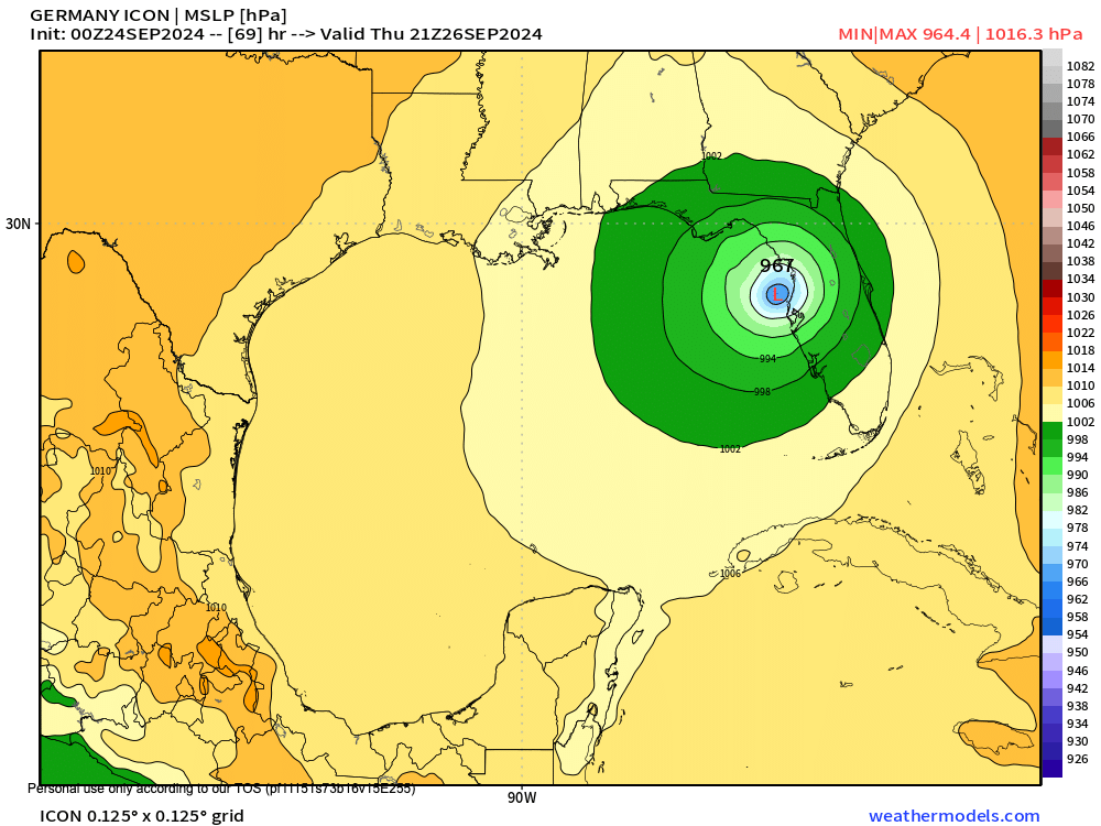
lsuhurricane wrote:Steve,
Its actually 964 mb on landfall per the stamp on Weathermodels
https://i.postimg.cc/j5p8Ds6m/13-km-ICON-MSLP-MSLP-69-1.png

MetroMike wrote:lsuhurricane wrote:Steve,
Its actually 964 mb on landfall per the stamp on Weathermodels
https://i.postimg.cc/j5p8Ds6m/13-km-ICON-MSLP-MSLP-69-1.png
Good thing the ICON model is not one of the main models
that are taken more seriously.
DunedinDave wrote:Man the ICON isn’t budging.
In the end, it might be right. Hope not. People in Tampa Bay are writing this off based on “models” taking this to panhandle. Even meteorologist here said we are looking in good shape.
Noles2016 wrote:DunedinDave wrote:Man the ICON isn’t budging.
In the end, it might be right. Hope not. People in Tampa Bay are writing this off based on “models” taking this to panhandle. Even meteorologist here said we are looking in good shape.
ICON is the one model that has budged the most since Saturday... has went from the left outlier to the right outlier.
Users browsing this forum: No registered users and 26 guests


