
Jeremy DeHart
@JeremyDeHart53d
·
Hard to understate this. The rate of rapid intensification explicitly forecast over the next few days by NHC ties their record maximum. This is exceptionally aggressive given it's still only a PTC, and shows how seriously they are taking the threat.
ATL: HELENE - Post-Tropical - Discussion
Moderator: S2k Moderators
Re: ATL: NINE - Potential Tropical Cyclone - Discussion
2 likes
The following post is NOT an official forecast and should not be used as such. It is just the opinion of the poster and may or may not be backed by sound meteorological data. It is NOT endorsed by any professional institution including storm2k.org For Official Information please refer to the NHC and NWS products.
Re: ATL: NINE - Potential Tropical Cyclone - Discussion
tolakram wrote:I'm not sure John's outflow will have any impact as the overall flow is all about a decaying front and the retrograding ULL in front of Nine. Not sure though, just an opinion.
https://i.imgur.com/xpiRKQz.gif
As that ULL digs southwest it will start ventilating the TC
2 likes

Re: ATL: NINE - Potential Tropical Cyclone - Discussion
StPeteMike wrote:TampaCE wrote:I just left Publix on 4th Street here in St Pete and decided to go grab some extra waters and it’s still fully stocked. Got to talking to the kid stocking shelves and had two people overhear us and say they did not even know a storm was brewing. It’s nuts how unprepared people are. People were shopping like it was a normal Monday night and getting their weekly groceries.
Hey neighbor, my gym is right there!
Yeah I’m just sitting outside at a coffee shop and was talking to a friend about the storm because his mom called telling him to buy supplies and someone walking by stopped and asked “what storm”. I’m not looking forward of the evacuation when it occurs. Even with current track and the project storm surge, Zone A and B would have to evacuate. I hope that we have a grasp by morning ( was hoping it was today) and the county can release mandatory orders for Zone A.
I got a message from school board earlier today and they are meeting at 11 tomorrow morning. I assume the evacuations will come shortly after that meeting with the County.
3 likes
Re: ATL: NINE - Potential Tropical Cyclone - Discussion
xironman wrote:3090 wrote:xironman wrote:Upper level winds abating over it as predicted by NHC, we may have a core by tonight's flight
https://i.imgur.com/zSqpgWD.gif
LONG way to go. ULL over the northeast yucatan peninsula is inhibiting 97. And John (outflow) in the Pacific is not moving fast enough to allow the ULL to move west. It is all interconnected.
The trough is retrograding 12z toughing the Isle of Youth:
https://i.imgur.com/CxUPtE2.gif
21z tip of Cuba:
https://i.imgur.com/ESjM8Kl.gif
Like I said. Still a ways to go.
0 likes
Re: ATL: NINE - Potential Tropical Cyclone - Discussion
Jr0d wrote:Blown Away wrote:[url]https://i.postimg.cc/vHjb85Gj/goes16-vis-09-L-202409231955.gif [/url]
The very broad exposed circulation @18.1N/82.2W per 5pm appears to be dissipating and likely the mid level circulation to the NE near the convection may take over. The models have been showing this bouncing around for next @24hours. JMHO
If the center relocated further east where I am seeing a possible MLC, that might really cause some concern for West Florida.
It certainly does seem like the broad swirl is dissipating convection is really start to wrap further east.
Even though I am not currently in the danger zone, I am still concerned and can't help but watch every satellite image coming in. I think it's time to take a break, let the models input the improved days and hopefully I don't wake up to a major surprise tomorrow.
Is it possible....that invest 97L tracks up the Florida peninsula itself?....I am thinking in terms of a true center forming eastward enough...to cause such a track?....
0 likes
-
jlauderdal
- S2K Supporter

- Posts: 7240
- Joined: Wed May 19, 2004 5:46 am
- Location: NE Fort Lauderdale
- Contact:
Re: ATL: NINE - Potential Tropical Cyclone - Discussion
I am another person that cares about Key West, especially when there are systems coming from the SW into SEFL.eastcoastFL wrote:Jr0d wrote:jlauderdal wrote:The trend has been east for 36 hours. Anyone on the right side of the track within 100 miles needs to be preparing for a major hurricane, including Key West. NHC usually nails it, but even if they "nail" it, small deviations make huge differences extrapolated over time.
I can tell you the attitude in Key West right now is it will be well west of us and all we will see is outer rain bands and minor surge.
Hopefully we get spared the worst again, however the emergency planners need to decide early tomorrow if they will evacuate tourists. Only one road out so evacuating is a nightmare. They generally are extremely hesitant to issue evacuation orders for tourist, they will issue the order for mobile homes and live aboard vessels before they tell tourists to leave.
We got extremely lucky with Ian, just a little wobble east would have brought hurricane conditions and even worse surge. No evacuation orders were issued and we had tourist playing in the flood waters and high winds.
I feel like you say this every storm. Key West is under the gun and nobody ever seems to care very much besides you. I'm glad you pay attention to the tropics.
2 likes
Re: ATL: NINE - Potential Tropical Cyclone - Discussion
https://x.com/TreyceJonesWX/status/1838273024702771325/photo/1
This picture is insane. The State will be in a mass panic if anything close to that verifies.
This picture is insane. The State will be in a mass panic if anything close to that verifies.
2 likes
The following post is NOT an official forecast and should not be used as such. It is just the opinion of the poster and may or may not be backed by sound meteorological data. It is NOT endorsed by any professional institution including storm2k.org For Official Information please refer to the NHC and NWS products.
Re: ATL: NINE - Potential Tropical Cyclone - Discussion
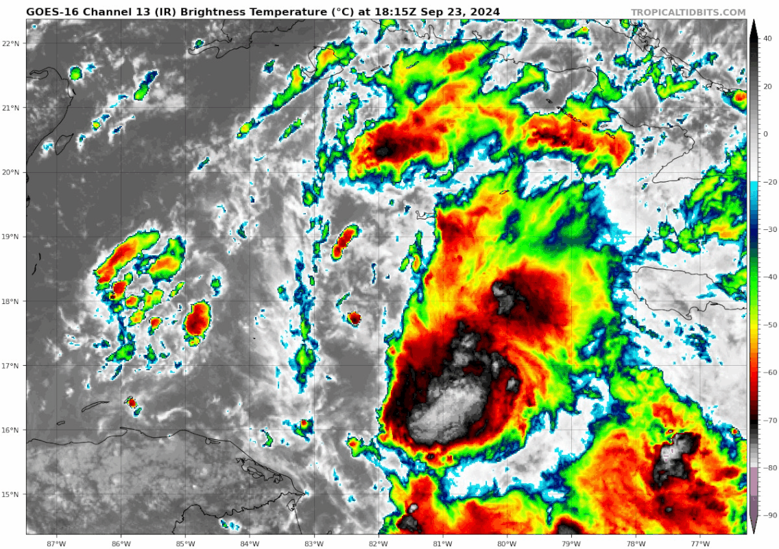
This system looks well on its way to me...with organizing and expanding convection. Now a long night is on the way with this thing over max OHC...I think once it organizes we are going to see relentless deepening
2 likes
-
jasons2k

- Storm2k Executive

- Posts: 8290
- Age: 52
- Joined: Wed Jul 06, 2005 12:32 pm
- Location: The Woodlands, TX
Re: ATL: NINE - Potential Tropical Cyclone - Discussion
sponger wrote:https://x.com/TreyceJonesWX/status/1838273024702771325/photo/1
This picture is insane. The State will be in a mass panic if anything close to that verifies.
Hurricane Phoenix


Hope that doesn’t happen.
4 likes
-
skillz305
- Category 1

- Posts: 312
- Joined: Sat Sep 08, 2018 11:10 am
- Location: Miami, Florida --> Vero Beach, Florida
Re: ATL: NINE - Potential Tropical Cyclone - Discussion
As always, Dr. Levi always lays out the reality of what's going on. Must watch if you have any uncertainty of its path.
https://www.youtube.com/watch?v=Mf_us-lsOXY
https://www.youtube.com/watch?v=Mf_us-lsOXY
2 likes
 Hurricanes: Andrew 1992 - Irene 1999 - Frances 2004 - Jeanne 2004 - Katrina 2005 - Wilma 2005 - Matthew 2016 - Irma 2017 - Ian 2022 - Nicole 2022 - Milton 2024
Re: ATL: NINE - Potential Tropical Cyclone - Discussion
psyclone wrote:This system looks well on its way to me...with organizing and expanding convection. Now a long night is on the way with this thing over max OHC...I think once it organizes we are going to see relentless deepening
Going to be a long couple of days! Sitting here in Western Saint Augustine, this could be the worst we have had in 2 decades or another scrape like in August where people 100 miles North of me get far worse. At least the data is flowing and we should have a solid track tomorrow afternoon. The intensity forecast is another story.
1 likes
The following post is NOT an official forecast and should not be used as such. It is just the opinion of the poster and may or may not be backed by sound meteorological data. It is NOT endorsed by any professional institution including storm2k.org For Official Information please refer to the NHC and NWS products.
-
StPeteMike

- Category 2

- Posts: 657
- Joined: Thu Jun 07, 2018 11:26 pm
Re: ATL: NINE - Potential Tropical Cyclone - Discussion
underthwx, Highly unlikely. The trough would not be that far south to shove it into South Florida. It could get put into Central Florida and then travel the spine from there, but I wouldn’t expect anymore south of I-4 area
2 likes
The above post is not official and should not be used as such. It is the opinion of the poster and may or may not be backed by sound meteorological data. It is not endorsed by any professional institution or storm2k.org. For official information, please refer to the NHC and NWS products.
Re: ATL: NINE - Potential Tropical Cyclone - Discussion
TampaCE wrote:I just left Publix on 4th Street here in St Pete and decided to go grab some extra waters and it’s still fully stocked. Got to talking to the kid stocking shelves and had two people overhear us and say they did not even know a storm was brewing. It’s nuts how unprepared people are. People were shopping like it was a normal Monday night and getting their weekly groceries.
Walmart in St Petersburg was very quiet and had few shoppers a little bit earlier today.
2 likes
Re: ATL: NINE - Potential Tropical Cyclone - Discussion
sweetpea wrote:TallyTracker wrote:underthwx wrote:What worries me...are the NHC intensities listed in the first advisory on PTC 9......I will not be surprised to see these intensities rise....as the soon to be cyclone gains strength....not to be an alarmist....but these possibilities have already justified everyone's immediate attention....give thought to getting out of this systems way....until it passes....I am so sorty yall have to go thru this.....true that....
Got my hotel tentatively booked in Alabama. If it shifts west, I shift west too.
I am in Sopchoppy and booked a hotel in northern Tally yesterday, but, I am rethinking that right now. Might head Alabama way. I just didn't want to be too far away. Stay safe!
You should be headed to Vero Beach or other South and East areas, NOT north or west.
2 likes
Cleo - 1964, Betsy - 1965, David - 1979, Andrew - 1992, Charlie (Francis, Ivan, Jeanne) - 2004, Irma - 2017, Ian - 2022, Milton - 2024
Re: ATL: NINE - Potential Tropical Cyclone - Discussion
Cayman radar could be interesting if it tracks a bit north https://www.weather.gov.ky/radar
2 likes


Re: ATL: NINE - Potential Tropical Cyclone - Discussion
Until this is named the general public will pay no mind to this before. Gas stations are only normal busy Publix stores not really much more than usual. Could be a last day rush problem.
Last edited by MetroMike on Mon Sep 23, 2024 6:18 pm, edited 1 time in total.
4 likes
-
eastcoastFL

- Category 5

- Posts: 3996
- Age: 44
- Joined: Thu Apr 12, 2007 12:29 pm
- Location: Palm City, FL
Re: ATL: NINE - Potential Tropical Cyclone - Discussion
3090 wrote:xironman wrote:Upper level winds abating over it as predicted by NHC, we may have a core by tonight's flight
https://i.imgur.com/zSqpgWD.gif
LONG way to go. ULL over the northeast yucatan peninsula is inhibiting 97. And John (outflow) in the Pacific is not moving fast enough to allow the ULL to move west. It is all interconnected.
It doesn't look like that ULL or John will make much of a difference in 24 hours.
3 likes
Personal Forecast Disclaimer:
The posts in this forum are NOT official forecast and should not be used as such. They are just the opinion of the poster and may or may not be backed by sound meteorological data. They are NOT endorsed by any professional institution or storm2k.org. For official information, please refer to the NHC and NWS products.
The posts in this forum are NOT official forecast and should not be used as such. They are just the opinion of the poster and may or may not be backed by sound meteorological data. They are NOT endorsed by any professional institution or storm2k.org. For official information, please refer to the NHC and NWS products.
-
PavelGaborik10
- Category 1
- Posts: 472
- Joined: Tue Sep 04, 2018 3:23 pm
Re: ATL: NINE - Potential Tropical Cyclone - Discussion
xironman wrote:PavelGaborik10 wrote:Still looks like a disorganized mess, hopefully this trend continues through tonight into the morning.
At 42057 the pressure has dropped to 1003.5 as the storm is moving away from it. It is strengthening.
Sure, but organization has been slow and hopefully John can contribute to this taking even longer to really get going and building a proper inner core.
0 likes
Re: ATL: NINE - Potential Tropical Cyclone - Discussion
This is an excerpt from the 4:10 pm Mobie NWS Forecast discussion
I wanted to share with yall, which may help add some clarity to the
forecast and evolution of Invest 97L...
I wanted to share with yall, which may help add some clarity to the
forecast and evolution of Invest 97L...
All eyes during the short term period will be on the Gulf of
Mexico, where a strong Tropical Storm or Hurricane is expected to
be entering the southern Gulf. The eventual motion of the system
will depend on the interaction of developing longwave trough
digging across the Mississippi River Valley and an upper ridge
over the western Atlantic. Models have trended stronger with the
upper trough and as a result the forecast track has moved
eastward. An upper low is forecast to cutoff at the base of this
trough and drift westward Wednesday into Thursday. These systems
like to take the path of least resistance which leads to a track
toward the FL big bend area in the break between the trough to the
west and ridge to the east. Air Force aircraft is currently
investigating the area around Potential Tropical Cyclone 9 which
will likely be a tropical storm by Tuesday morning. This data
along with increased upper air data will hopefully continue to
help models resolve the storms track and intensity. We will have
to continue to watch for track changes as there are a few GFS
ensemble members that have a further west track. Regardless,
this system will bring very hazardous marine conditions.
1 likes

Re: ATL: NINE - Potential Tropical Cyclone - Discussion
5 likes
TC naming lists: retirements and intensity
Most aggressive Advisory #1's in North Atlantic (cr. kevin for starting the list)
Most aggressive Advisory #1's in North Atlantic (cr. kevin for starting the list)
Who is online
Users browsing this forum: No registered users and 41 guests