
CMC (just getting to see it now) has that part 2 in 10 days depicted.
https://www.tropicaltidbits.com/analysi ... 312&fh=240
ATL: HELENE - Models
Moderator: S2k Moderators
Re: ATL: NINE - Models
1 likes

Re: ATL: NINE - Models
Welcome back Wilma.
11 likes
Igor 2010, Sandy 2012, Fay 2014, Gonzalo 2014, Joaquin 2015, Nicole 2016, Humberto 2019, Imelda 2025
I am only a tropical weather enthusiast. My predictions are not official and may or may not be backed by sound meteorological data. For official information, please refer to the NHC and NWS products.
I am only a tropical weather enthusiast. My predictions are not official and may or may not be backed by sound meteorological data. For official information, please refer to the NHC and NWS products.

Re: ATL: NINE - Models
160-165 kt and 899 mbar on the HAFS-A. Welcome back Hurricane Rita.
5 likes
Irene '11 Sandy '12 Hermine '16 5/15/2018 Derecho Fay '20 Isaias '20 Elsa '21 Henri '21 Ida '21
I am only a meteorology enthusiast who knows a decent amount about tropical cyclones. Look to the professional mets, the NHC, or your local weather office for the best information.
I am only a meteorology enthusiast who knows a decent amount about tropical cyclones. Look to the professional mets, the NHC, or your local weather office for the best information.
-
StPeteMike

- Category 2

- Posts: 657
- Joined: Thu Jun 07, 2018 11:26 pm
Re: ATL: NINE - Models
Looking at satellite image and the models, the GFS seems to be the only one closely depicting the current set-up of the trough.
Maybe it’s my untrained eye, but the rest seem to be weaker or slower than what is currently occurring.
Maybe it’s my untrained eye, but the rest seem to be weaker or slower than what is currently occurring.
0 likes
The above post is not official and should not be used as such. It is the opinion of the poster and may or may not be backed by sound meteorological data. It is not endorsed by any professional institution or storm2k.org. For official information, please refer to the NHC and NWS products.
-
Blown Away

- S2K Supporter

- Posts: 10253
- Joined: Wed May 26, 2004 6:17 am
Re: ATL: NINE - Models
12z HWRF Trend… Decent E shift over W Cuba now…
2 likes
Hurricane Eye Experience: David 79, Irene 99, Frances 04, Jeanne 04, Wilma 05… Hurricane Brush Experience: Andrew 92, Erin 95, Floyd 99, Matthew 16, Irma 17, Ian 22, Nicole 22…
-
Lightning48
- Tropical Low

- Posts: 33
- Joined: Mon Mar 07, 2022 12:06 pm

Re: ATL: NINE - Models
Lightning48 wrote:Is the possibility of East shifts still possible?
I was thinking West Shifts with this system moving slower than expected.
0 likes
Personal Forecast Disclaimer:
The posts in this forum are NOT official forecast and should not be used as such. They are just the opinion of the poster and may or may not be backed by sound meteorological data. They are NOT endorsed by any professional institution or storm2k.org. For official information, please refer to the NHC and NWS products.
The posts in this forum are NOT official forecast and should not be used as such. They are just the opinion of the poster and may or may not be backed by sound meteorological data. They are NOT endorsed by any professional institution or storm2k.org. For official information, please refer to the NHC and NWS products.

Re: ATL: NINE - Models
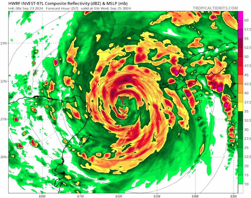
Is this the strongest ever HAFS run for the Atlantic? It's gotta be close, need recon data ingested to believe it but still...ElectricStorm wrote:Posted with no comment

2 likes

Re: ATL: NINE - Models
ElectricStorm wrote:Posted with no comment
https://i.imgur.com/iOfIYp5.png
Good stuff LOL; Wind (barbs) seem a tad "slack" given the pressure though
0 likes
Andy D
(For official information, please refer to the NHC and NWS products.)
(For official information, please refer to the NHC and NWS products.)

Re: ATL: NINE - Models
WOW, those 12Z HAFS runs are absolutely insane, HAFS-B ties the Atlantic low pressure record at 72 hours. Maybe one of the craziest model runs I've seen behind those Irma sub-900mb into Miami runs.
There's the caveat of uncertainty of hurricane models' accuracy before a singular area of vorticity has consolidated, but these still show just how favorable conditions in the gulf are right now.
There's the caveat of uncertainty of hurricane models' accuracy before a singular area of vorticity has consolidated, but these still show just how favorable conditions in the gulf are right now.
1 likes
-
chris_fit

- Category 5

- Posts: 3261
- Age: 43
- Joined: Wed Sep 10, 2003 11:58 pm
- Location: Tampa Bay Area, FL
Re: ATL: NINE - Models
12Z Euro with what looks like a slight E Shift. All the nasty weather on the east side. Hurricane force gusts well inland and in Tampa.


Last edited by chris_fit on Mon Sep 23, 2024 12:50 pm, edited 1 time in total.
1 likes
-
WaveBreaking

- Category 2
- Posts: 728
- Joined: Sun Jun 30, 2024 11:33 am
- Location: US
Re: RE: Re: ATL: NINE - Models
Woofde wrote:Is this the strongest ever HAFS run for the Atlantic? It's gotta be close, need recon data ingested to believe it but still...ElectricStorm wrote:Posted with no comment
https://i.imgur.com/iOfIYp5.png
Iirc some of the HAFS runs for Lee and the failed Invest 97L in October got down to the 890s, but none of them have shown 880s before.
Also, as a “fun” fact, if this run played out verbatim, then soon-to-be Helene would break Rita’s record of being the most intense GOM hurricane (Rita bottomed out at 895 mbar and 155kt winds).
1 likes
I am NOT a professional meteorologist, so take all of my posts with a grain of salt. My opinions are mine and mine alone.

Re: ATL: NINE - Models
Not suprising. Its the magical loop current..We saw what it did to Charley with excellent conditions aloft. Not thinking sub 900 Rita-ish but it is concerning... JMO
3 likes
Re: ATL: NINE - Models
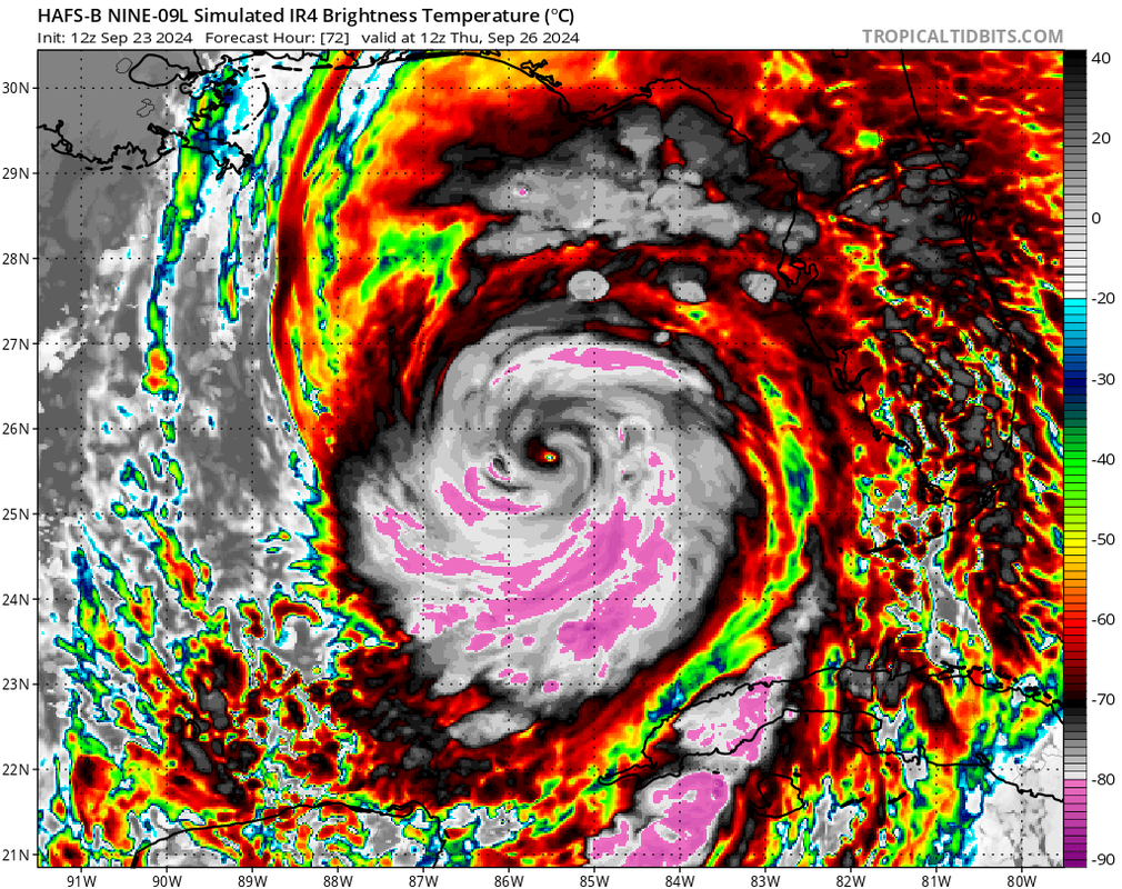
Hurricane models are divided into two camps about the structural evolution of Helene.
The HWRF and HAFS-B show a pinhole eye with a developing outer eyewall. How soon this outer eyewall overpowers the pinhole varies between the two. The HWRF has it destroy Helene very quickly, the HAFS-B…do not lol.
The HMON and HAFS-B both show more normal-sized cores without significant outer eyewalls. Both still manage to hit sub-920 mbar pressures.
1 likes
Irene '11 Sandy '12 Hermine '16 5/15/2018 Derecho Fay '20 Isaias '20 Elsa '21 Henri '21 Ida '21
I am only a meteorology enthusiast who knows a decent amount about tropical cyclones. Look to the professional mets, the NHC, or your local weather office for the best information.
I am only a meteorology enthusiast who knows a decent amount about tropical cyclones. Look to the professional mets, the NHC, or your local weather office for the best information.
-
ElectricStorm

- Category 5
- Posts: 5156
- Age: 25
- Joined: Tue Aug 13, 2019 11:23 pm
- Location: Norman, OK
Re: ATL: NINE - Models
Once again though keep in mind the HAFS struggle before a TC actually develops so while it's fun to look at nuclear runs like these you can't really put any stock in them
1 likes
B.S Meteorology, University of Oklahoma '25
Please refer to the NHC, NWS, or SPC for official information.
Please refer to the NHC, NWS, or SPC for official information.
-
ConvergenceZone
.gif)
- Category 5
- Posts: 5241
- Joined: Fri Jul 29, 2005 1:40 am
- Location: Northern California
Re: ATL: NINE - Models
I've said this before, but thank god this storm will be moving at an absolute lightning speed. It's going to be over as quick as it starts. Talk about a quit hit system.
0 likes
-
DunedinDave
- Category 1

- Posts: 269
- Joined: Fri Aug 25, 2023 10:31 am
Re: ATL: NINE - Models
ConvergenceZone wrote:I've said this before, but thank god this storm will be moving at an absolute lightning speed. It's going to be over as quick as it starts. Talk about a quit hit system.
Yup. Charley was like that. Was moving at like 25mph when it hit Port Charlotte. Goes to show you just because it's moving fast doesn't mean it can't cause a ton of damage.
Only thing that worries me about "projected" NE turns in the Gulf is the sharpness of those turns. They always seem to go more right than forecast. I mean, who can forget Ian? I'll never forget the meteorologist coming on the morning before saying it's started its turn early. And this is basically the same exact track as Ian when it was entering the Gulf except maybe 50-75 miles West.
1 likes
-
SFLcane

- S2K Supporter
- Posts: 10281
- Age: 48
- Joined: Sat Jun 05, 2010 1:44 pm
- Location: Lake Worth Florida
Re: RE: Re: ATL: NINE - Models
Woofde wrote:Is this the strongest ever HAFS run for the Atlantic? It's gotta be close, need recon data ingested to believe it but still...ElectricStorm wrote:Posted with no comment
https://i.imgur.com/iOfIYp5.png
Thankfully that is 100% nonsense very far anchored from reality.
0 likes

Re: ATL: NINE - Models
while i generally agree with y'all about it being a good thing moving away faster, it also means more widespread damage further inland...
like those who mentioned Charlie, we had some of the worst damage ever here in central florida all the way up to Jax from a storm that landed hundreds of miles away
like those who mentioned Charlie, we had some of the worst damage ever here in central florida all the way up to Jax from a storm that landed hundreds of miles away
5 likes
Just like Jon Snow..."I know nothing" except what I know, and most of what I know is gathered by the fine people of the NHC
-
ConvergenceZone
- Category 5
- Posts: 5241
- Joined: Fri Jul 29, 2005 1:40 am
- Location: Northern California
Re: RE: Re: ATL: NINE - Models
SFLcane wrote:Woofde wrote:Is this the strongest ever HAFS run for the Atlantic? It's gotta be close, need recon data ingested to believe it but still...ElectricStorm wrote:Posted with no comment
https://i.imgur.com/iOfIYp5.png
Thankfully that is 100% nonsense very far anchored from reality.
Yea it pulls this crap with almost every storm lol. I never take it serous to be honest, just look at it as fantasy entertainment.
Last edited by ConvergenceZone on Mon Sep 23, 2024 1:13 pm, edited 1 time in total.
0 likes
Who is online
Users browsing this forum: No registered users and 37 guests