ATL: HELENE - Models
Moderator: S2k Moderators

Re: ATL: INVEST 97L - Models
HAFS-B so far is weaker and slightly west of the HAFS-A. Makes a brief landfall on the tip of the Yucatan as a 55-65 kt TS/C1. Overall structure looks weaker and it takes a minor hit from the Yucatan.
0 likes
Irene '11 Sandy '12 Hermine '16 5/15/2018 Derecho Fay '20 Isaias '20 Elsa '21 Henri '21 Ida '21
I am only a meteorology enthusiast who knows a decent amount about tropical cyclones. Look to the professional mets, the NHC, or your local weather office for the best information.
I am only a meteorology enthusiast who knows a decent amount about tropical cyclones. Look to the professional mets, the NHC, or your local weather office for the best information.
-
AnnularCane

- S2K Supporter

- Posts: 2964
- Joined: Thu Jun 08, 2006 9:18 am
- Location: Wytheville, VA
Re: ATL: INVEST 97L - Models
Keldeo1997 wrote:https://cdn.discordapp.com/attachments/697996354537914448/1287536766877700178/Screenshot_205.png?ex=66f1e78e&is=66f0960e&hm=21693aab7f0bd48d6ffaea198c0181c2fb474960046b0a0a382cd70bebe2f476&
Not what you want to see on the GEFS. Most of these members are very strong.
What's causing that westward bend after landfall? They usually curve northeast at some point.
0 likes
"But it never rained rain. It never snowed snow. And it never blew just wind. It rained things like soup and juice. It snowed mashed potatoes and green peas. And sometimes the wind blew in storms of hamburgers." -- Judi Barrett, Cloudy with a Chance of Meatballs

Re: ATL: INVEST 97L - Models
18 gefs ensembles show western panhandle panama city in the cross hairs for now
0 likes
Robbielyn McCrary
I know just about enough to sound like I know what I'm talking about sometimes. But for your safety please follow the nhc for truly professional forecasting.
I know just about enough to sound like I know what I'm talking about sometimes. But for your safety please follow the nhc for truly professional forecasting.
-
DunedinDave
- Category 1

- Posts: 269
- Joined: Fri Aug 25, 2023 10:31 am
Re: ATL: INVEST 97L - Models
robbielyn wrote:18 gefs ensembles show western panhandle panama city in the cross hairs for now
That’s surprising because they had been all over the Fla west coast up until this morning. I wonder why the sudden shift if the NAM is showing that low moving more east than expected.
0 likes

Re: ATL: INVEST 97L - Models
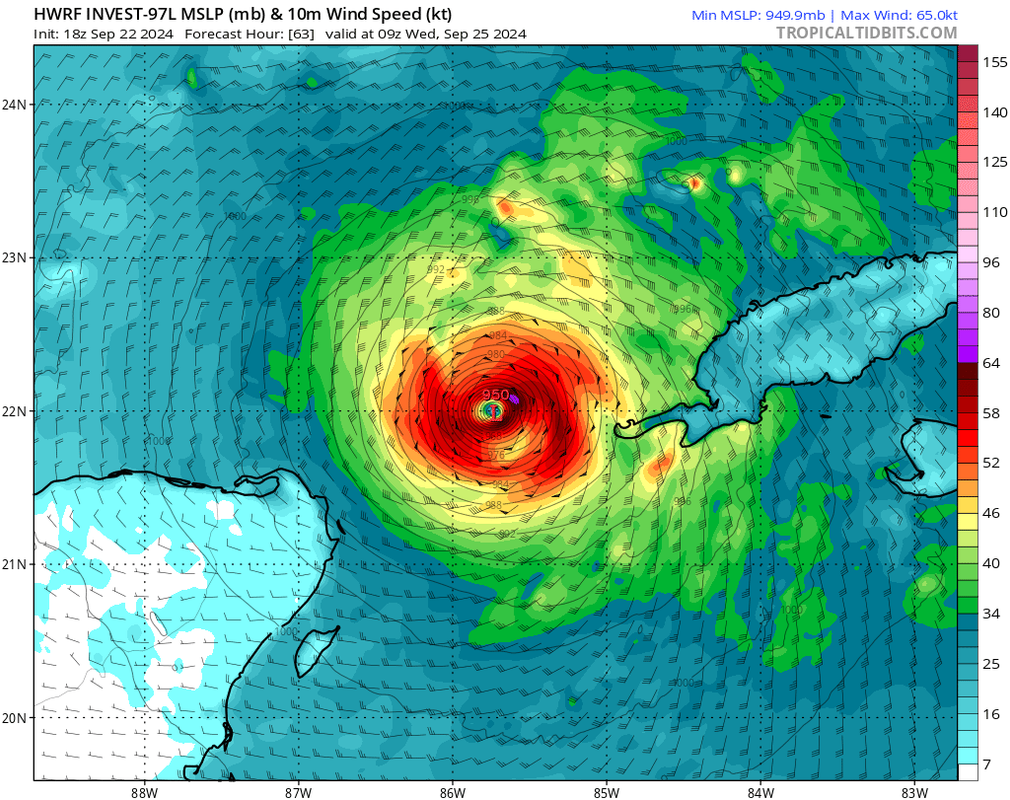
How is HWRF showing a 950 mb storm with only 65 kt winds?
3 likes
TC naming lists: retirements and intensity
Most aggressive Advisory #1's in North Atlantic (cr. kevin for starting the list)
Most aggressive Advisory #1's in North Atlantic (cr. kevin for starting the list)
-
ConvergenceZone
.gif)
- Category 5

- Posts: 5241
- Joined: Fri Jul 29, 2005 1:40 am
- Location: Northern California
Re: ATL: INVEST 97L - Models
Teban54 wrote:How is HWRF showing a 950 mb storm with only 65 kt winds?
https://i.postimg.cc/jjgS01Rr/image.png
That's just a printing error
1 likes
-
gatorcane

- S2K Supporter
- Posts: 23708
- Age: 48
- Joined: Sun Mar 13, 2005 3:54 pm
- Location: Boca Raton, FL
Re: ATL: INVEST 97L - Models
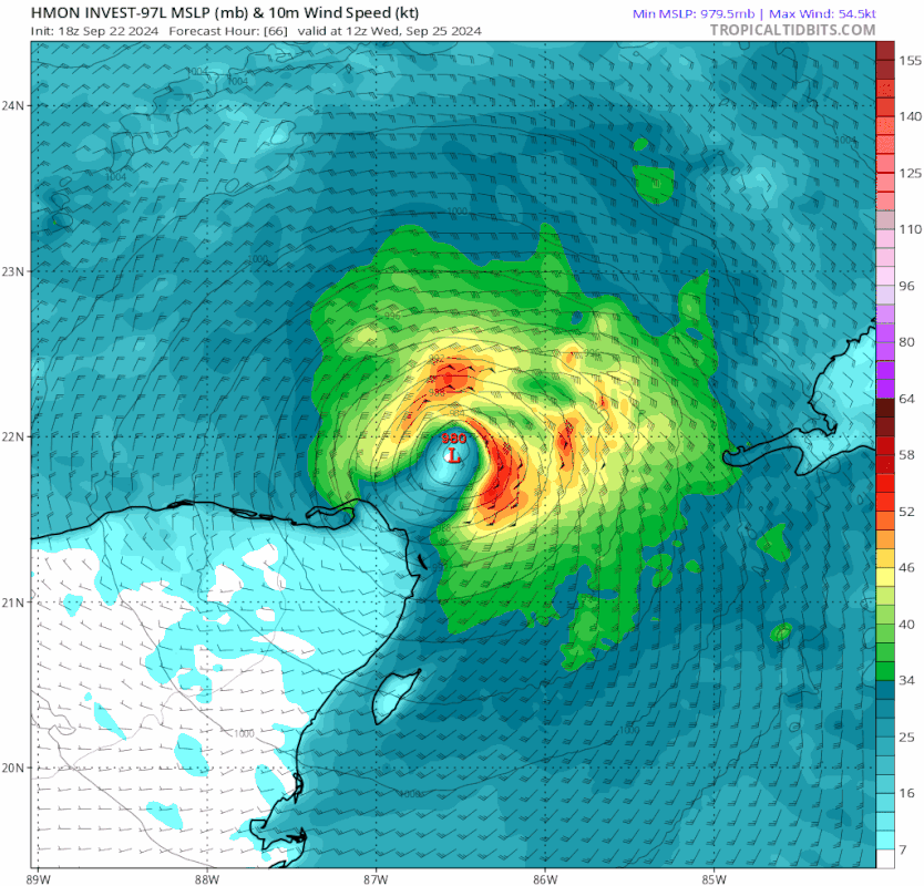
HMON headed for a peninsula landfall. 942MB at 102 hours. 
Last edited by gatorcane on Sun Sep 22, 2024 6:49 pm, edited 3 times in total.
2 likes

Re: ATL: INVEST 97L - Models
Teban54 wrote:How is HWRF showing a 950 mb storm with only 65 kt winds?
https://i.postimg.cc/jjgS01Rr/image.png
I don't even pay attention to the winds on the hurricane models. They always seem to be off.
0 likes
-
SouthFLTropics

- Category 5
- Posts: 4258
- Age: 50
- Joined: Thu Aug 14, 2003 8:04 am
- Location: Port St. Lucie, Florida
Re: ATL: INVEST 97L - Models
HMON, just north of Tampa. OUCH. That'll push some storm surge into Tampa Bay.
2 likes
Fourth Generation Florida Native
Personal Storm History: David 79, Andrew 92, Erin 95, Floyd 99, Irene 99, Frances 04, Jeanne 04, Wilma 05, Matthew 16, Irma 17, Ian 22, Nicole 22, Milton 24
Personal Storm History: David 79, Andrew 92, Erin 95, Floyd 99, Irene 99, Frances 04, Jeanne 04, Wilma 05, Matthew 16, Irma 17, Ian 22, Nicole 22, Milton 24
-
USTropics
- Professional-Met

- Posts: 2739
- Joined: Sun Aug 12, 2007 3:45 am
- Location: Florida State University
Re: ATL: INVEST 97L - Models
AnnularCane wrote:Keldeo1997 wrote:https://cdn.discordapp.com/attachments/697996354537914448/1287536766877700178/Screenshot_205.png?ex=66f1e78e&is=66f0960e&hm=21693aab7f0bd48d6ffaea198c0181c2fb474960046b0a0a382cd70bebe2f476&
Not what you want to see on the GEFS. Most of these members are very strong.
What's causing that westward bend after landfall? They usually curve northeast at some point.
There ends up being some ridging that builds in to the north, so movement is dictated by the ULL to the west (it pivots around this as highlighted in pink):

The upper level pattern gives a better depiction of the steering:

2 likes
Re: ATL: INVEST 97L - Models
robbielyn wrote:18 gefs ensembles show western panhandle panama city in the cross hairs for now
I see an equal amount east of apalchicola as I do west.
Last edited by caneman on Sun Sep 22, 2024 6:53 pm, edited 1 time in total.
0 likes
-
SouthFLTropics
- Category 5
- Posts: 4258
- Age: 50
- Joined: Thu Aug 14, 2003 8:04 am
- Location: Port St. Lucie, Florida
Re: ATL: INVEST 97L - Models
HWRF at 72 hours shows an easterly component to its movement also and is down to 934MB
1 likes
Fourth Generation Florida Native
Personal Storm History: David 79, Andrew 92, Erin 95, Floyd 99, Irene 99, Frances 04, Jeanne 04, Wilma 05, Matthew 16, Irma 17, Ian 22, Nicole 22, Milton 24
Personal Storm History: David 79, Andrew 92, Erin 95, Floyd 99, Irene 99, Frances 04, Jeanne 04, Wilma 05, Matthew 16, Irma 17, Ian 22, Nicole 22, Milton 24
-
DunedinDave
- Category 1
- Posts: 269
- Joined: Fri Aug 25, 2023 10:31 am
Re: ATL: INVEST 97L - Models
Please tell me the HMON model isn’t reliable. I see a 940 mb storm with the eye wall slamming Pinellas County.
1 likes
-
SouthFLTropics
- Category 5
- Posts: 4258
- Age: 50
- Joined: Thu Aug 14, 2003 8:04 am
- Location: Port St. Lucie, Florida
Re: ATL: INVEST 97L - Models
HMON into Citrus County at 942MB in 102 hours.
0 likes
Fourth Generation Florida Native
Personal Storm History: David 79, Andrew 92, Erin 95, Floyd 99, Irene 99, Frances 04, Jeanne 04, Wilma 05, Matthew 16, Irma 17, Ian 22, Nicole 22, Milton 24
Personal Storm History: David 79, Andrew 92, Erin 95, Floyd 99, Irene 99, Frances 04, Jeanne 04, Wilma 05, Matthew 16, Irma 17, Ian 22, Nicole 22, Milton 24

Re: ATL: INVEST 97L - Models
DunedinDave wrote:Please tell me the HMON model isn’t reliable. I see a 940 mb storm with the eye wall slamming Pinellas County.
I mean it outperformed all the other ones last year in 3 to 5 day forecasts. But I wouldn't take it as gospel, especially the very first run
1 likes
Re: ATL: INVEST 97L - Models
DunedinDave wrote:Please tell me the HMON model isn’t reliable. I see a 940 mb storm with the eye wall slamming Pinellas County.
We average 10-20 cat 3 or higher model storms per year.
3 likes
Re: ATL: INVEST 97L - Models
jfk08c wrote:DunedinDave wrote:Please tell me the HMON model isn’t reliable. I see a 940 mb storm with the eye wall slamming Pinellas County.
I mean it outperformed all the other ones last year in 3 to 5 day forecasts. But I wouldn't take it as gospel, especially the very first run
The silver lining is that, while HMON (and other hurricane models) are great at intensity forecasts, they're usually subpar for track forecasts IIRC.
0 likes
TC naming lists: retirements and intensity
Most aggressive Advisory #1's in North Atlantic (cr. kevin for starting the list)
Most aggressive Advisory #1's in North Atlantic (cr. kevin for starting the list)
-
DunedinDave
- Category 1
- Posts: 269
- Joined: Fri Aug 25, 2023 10:31 am
-
DunedinDave
- Category 1
- Posts: 269
- Joined: Fri Aug 25, 2023 10:31 am
Re: ATL: INVEST 97L - Models
Teban54 wrote:jfk08c wrote:DunedinDave wrote:Please tell me the HMON model isn’t reliable. I see a 940 mb storm with the eye wall slamming Pinellas County.
I mean it outperformed all the other ones last year in 3 to 5 day forecasts. But I wouldn't take it as gospel, especially the very first run
The silver lining is that, while HMON (and other hurricane models) are great at intensity forecasts, they're usually subpar for track forecasts IIRC.
That is good. *sighing a breath of relief*
0 likes
Who is online
Users browsing this forum: No registered users and 80 guests