Trough digs down more in that run, which I think is more likely. I have never trusted the earlier models that kept a ridge strong over FL and southeast CONUS.
3 days until the start of organization, everything can change.
I just remind everyone that if you don’t have your supplies all set, best to do so now. Anywhere between Fort Myers and Biloxi.
Low pressure developing over the western Caribbean Sea (Is Invest 97L)
Moderator: S2k Moderators
Forum rules

The posts in this forum are NOT official forecasts and should not be used as such. They are just the opinion of the poster and may or may not be backed by sound meteorological data. They are NOT endorsed by any professional institution or STORM2K. For official information, please refer to products from the National Hurricane Center and National Weather Service.
-
StPeteMike

- Category 2

- Posts: 657
- Joined: Thu Jun 07, 2018 11:26 pm
Re: Area of low pressure to develop over the western Caribbean sea (0/70)
0 likes
The above post is not official and should not be used as such. It is the opinion of the poster and may or may not be backed by sound meteorological data. It is not endorsed by any professional institution or storm2k.org. For official information, please refer to the NHC and NWS products.
-
SFLcane

- S2K Supporter

- Posts: 10281
- Age: 48
- Joined: Sat Jun 05, 2010 1:44 pm
- Location: Lake Worth Florida
Re: Area of low pressure to develop over the western Caribbean sea (0/70)
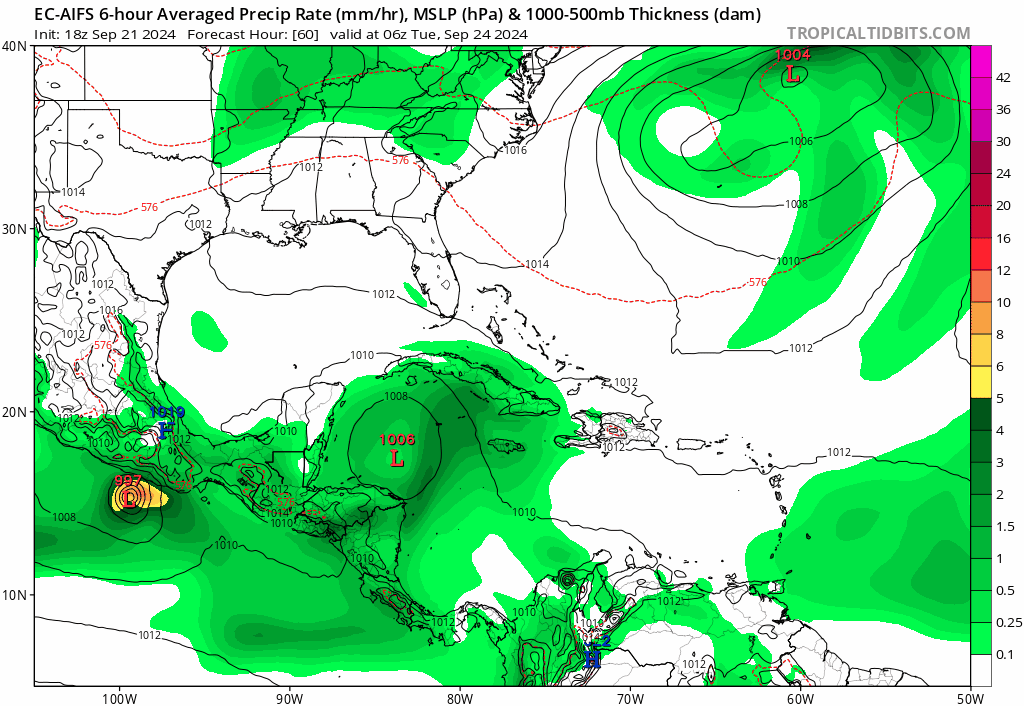
SFLcane wrote:gatorcane wrote:Another shift to the right by the EC-AIFS:
https://i.postimg.cc/5tGRDwSR/ec-aifs-mslp-pcpn-watl-fh60-138.gif
Hmm..
Speaking of Ai the models are showing one heck of signal for a wave of Africa AI has a monster north of PR.
1 likes
-
gatorcane

- S2K Supporter
- Posts: 23708
- Age: 48
- Joined: Sun Mar 13, 2005 3:54 pm
- Location: Boca Raton, FL
Re: Area of low pressure to develop over the western Caribbean sea (0/70)
Satellite images can be deceiving but certainly looks like it could form more to the east than some of the guidance has been showing, based on the 00Z models, NHC might have to extend the area for potential development east into more of the SE GOM and EGOM:

3 likes
-
dexterlabio
- Category 5

- Posts: 3517
- Joined: Sat Oct 24, 2009 11:50 pm
Re: Area of low pressure to develop over the western Caribbean sea (0/70)
Any chance of Francine 2.0?
0 likes
Personal Forecast Disclaimer:
The posts in this forum are NOT official forecast and should not be used as such. They are just the opinion of the poster and may or may not be backed by sound meteorological data. They are NOT endorsed by any professional institution or storm2k.org. For official information, please refer to the NHC and NWS products.
The posts in this forum are NOT official forecast and should not be used as such. They are just the opinion of the poster and may or may not be backed by sound meteorological data. They are NOT endorsed by any professional institution or storm2k.org. For official information, please refer to the NHC and NWS products.
-
StPeteMike
- Category 2
- Posts: 657
- Joined: Thu Jun 07, 2018 11:26 pm
Re: Area of low pressure to develop over the western Caribbean sea (0/70)
Whatever convection there was seems to be waning and looks to be detach from the main area of development to the west, just east/northeast of Honduras. The trough will eventually help fan the system, but currently is keep it disorganized with the shear to the north.
1 likes
The above post is not official and should not be used as such. It is the opinion of the poster and may or may not be backed by sound meteorological data. It is not endorsed by any professional institution or storm2k.org. For official information, please refer to the NHC and NWS products.
Re: Area of low pressure to develop over the western Caribbean sea (0/60)
Blown Away wrote:[url]https://i.postimg.cc/Ghf5T6MV/goes16-ir-watl.gif [/url]
ATM it appears the L would set up a little farther E.
I was just about to post that, in fact it seems to have moved a lot off the CA coastline.
0 likes

Re: Area of low pressure to develop over the western Caribbean sea (0/70)
Changing the gen oil tomorrow and starting the slow build up of Ethanol free fuel. I never take lightly a Fall Low South and West of me. Especially with that low shear forecast and good ventilation.
2 likes
The following post is NOT an official forecast and should not be used as such. It is just the opinion of the poster and may or may not be backed by sound meteorological data. It is NOT endorsed by any professional institution including storm2k.org For Official Information please refer to the NHC and NWS products.
-
Stratton23
- Category 5
- Posts: 3577
- Joined: Fri Jul 21, 2023 10:59 pm
- Location: Katy, Tx
Re: Area of low pressure to develop over the western Caribbean sea (0/70)
ICON 00z so far through hour 114 has stronger ridging over the SE US, system in the west central gulf at hour 114 with the cut off low diving down to the SW in texas
0 likes

Re: Area of low pressure to develop over the western Caribbean sea (0/70)
Stratton23 wrote:ICON 00z so far through hour 114 has stronger ridging over the SE US, system in the west central gulf at hour 114 with the cut off low diving down to the SW in texas
Looks like it hits the brakes and makes a b line to the big bend area of Florida. As a major hurricane 945mb landfall.
1 likes
-
Stratton23
- Category 5
- Posts: 3577
- Joined: Fri Jul 21, 2023 10:59 pm
- Location: Katy, Tx
Re: Area of low pressure to develop over the western Caribbean sea (0/70)
I have a hard time buying such a hard NE turn like that lol
0 likes
-
DunedinDave
- Category 1

- Posts: 269
- Joined: Fri Aug 25, 2023 10:31 am
Re: Area of low pressure to develop over the western Caribbean sea (0/70)
The ICON 0z is almost a carbon copy of that crazy 12z GFS run a couple days ago that took a cat 5 Hurricane east into the FLA west coast. Don’t tell me we’re re-opening that idea again.
0 likes
Re: Area of low pressure to develop over the western Caribbean sea (0/70)
Stratton23 wrote:I have a hard time buying such a hard NE turn like that lol
Yeah especially if it gets that far west
0 likes
Re: Area of low pressure to develop over the western Caribbean sea (0/70)
GFS already looks stronger
0 likes
-
REDHurricane

- Category 1
- Posts: 438
- Age: 28
- Joined: Sun Jul 03, 2022 2:36 pm
- Location: Northeast Pacific Ocean
Re: Area of low pressure to develop over the western Caribbean sea (0/70)
LAF92 wrote:Stratton23 wrote:ICON 00z so far through hour 114 has stronger ridging over the SE US, system in the west central gulf at hour 114 with the cut off low diving down to the SW in texas
Looks like it hits the brakes and makes a b line to the big bend area of Florida. As a major hurricane 945mb landfall.
Yeah I don't like that at all, ICON has been the most accurate model in the Gulf this year and it's not close (according to my very poor short to medium-term memory, please correct me if I'm wrong on any of these) -- first it nailed Beryl, can't exactly remember how it did for Chris but I think I recall all the models performing pretty equally, then it did a solid job with Debby, and finally it correctly predicted a landfall further to the east than GFS/Euro did up to about 5 days out for Francine. Any storm that has almost 4 entire days to hang out in the Gulf under an upper-level ridge has an extremely high top-end potential outcome, if that wasn't already obvious. It's still too early to get hung up on any particular model run, even ICON, because nothing resembling a real tropical disturbance is even there yet, but it'll be interesting nevertheless to see if the other models trend towards the ICON solution at all over the next ~24 hours and how ICON itself trends as well.
Last edited by REDHurricane on Sat Sep 21, 2024 10:58 pm, edited 1 time in total.
3 likes
Re: Area of low pressure to develop over the western Caribbean sea (0/70)
Pelicane wrote:GFS already looks stronger
Shooting the gap around 995mb similar to the 18z run
0 likes
-
Category5Kaiju

- Category 5
- Posts: 4347
- Joined: Thu Dec 24, 2020 12:45 pm
- Location: Seattle during the summer, Phoenix during the winter
Re: Area of low pressure to develop over the western Caribbean sea (0/70)
Whoa there, GFS already spinning this up as early as the day after tomorrow.
Looks like models are starting to consider earlier than anticipated development as a legitimate possibility
Looks like models are starting to consider earlier than anticipated development as a legitimate possibility
0 likes
Unless explicitly stated, all information in my posts is based on my own opinions and observations. Tropical storms and hurricanes can be extremely dangerous. Refer to an accredited weather research agency or meteorologist if you need to make serious decisions regarding an approaching storm.
Re: Area of low pressure to develop over the western Caribbean sea (0/70)
Looks similar to 18z intensity wise. Just a hair quicker and bit east.
0 likes

Re: Area of low pressure to develop over the western Caribbean sea (0/70)
Slightly more intense on this run, was gonna add that it looked like it was about a degree further west but it just took a northeastward turn on the last update. Net result is it's ended up being slightly east of the 18z run now
0 likes
Re: Area of low pressure to develop over the western Caribbean sea (0/70)
959 mb and a full degree east of 18z run now.
0 likes
Who is online
Users browsing this forum: ouragans and 97 guests