Low pressure developing over the western Caribbean Sea (Is Invest 97L)

This is the general tropical discussion area. Anyone can take their shot at predicting a storms path.

Moderator: S2k Moderators

Forum rules

The posts in this forum are NOT official forecasts and should not be used as such. They are just the opinion of the poster and may or may not be backed by sound meteorological data. They are NOT endorsed by any professional institution or STORM2K. For official information, please refer to products from the National Hurricane Center and National Weather Service.

Help Support Storm2K
Message
Author
TomballEd
Category 2
Category 2
Posts: 692
Age: 61
Joined: Wed Aug 16, 2023 4:52 pm
Location: Spring/Klein area, not Tomball

Re: Area of low pressure to develop over the western Caribbean sea (0/60)

#961 Postby TomballEd » Sat Sep 21, 2024 6:44 pm

I'm sure the 18Z GFS won't be accurate on either landfall location or intensity, the ensembles are still preferred at this range. Patting myself on the back on this one, why based on the 12Z GEFS with a few members in the 950s and 960s mb, I was reluctant to agree with the sloppy tropical storm or weak hurricane belief.

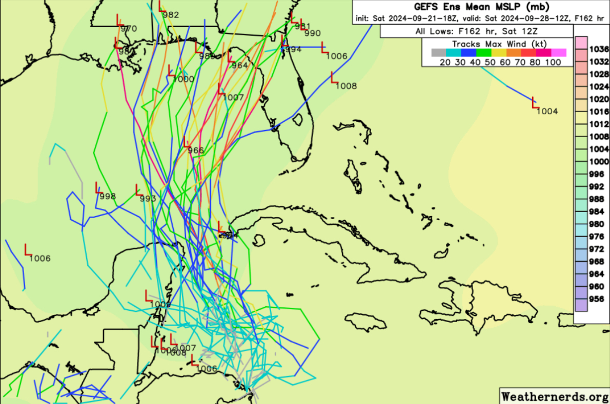
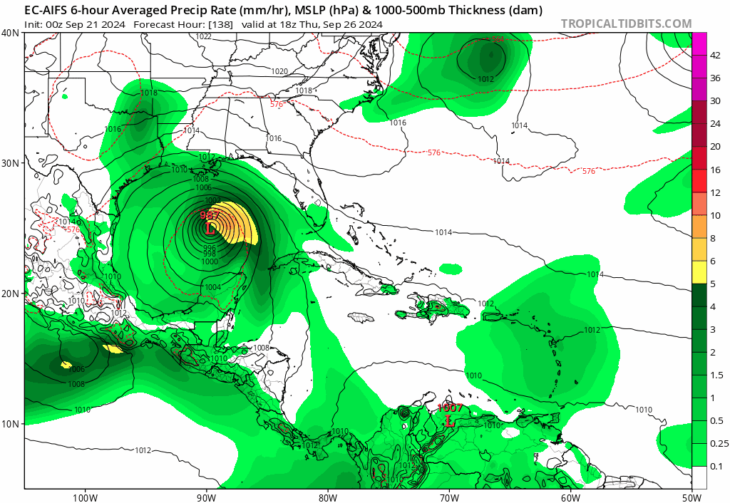
GEFS, ignoring a couple of outliers, still points somewhere from Fourchon/Grand Isle (spelling?) to Florida between Tampa and the Big Bend.

A couple of the ensemble members that miss Tampa probably still at least cause some higher tides.

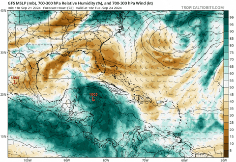
Back to the op run, the dry air doesn't reach the core before landfall, or this could strengthen all the way to the coast. Can't wait for the 0Z runs.

Image
0 likes   

User avatar
cheezyWXguy
Category 5
Category 5
Posts: 6108
Joined: Mon Feb 13, 2006 12:29 am
Location: Dallas, TX

Re: Area of low pressure to develop over the western Caribbean sea (0/60)

#962 Postby cheezyWXguy » Sat Sep 21, 2024 6:45 pm

DunedinDave wrote:
Steve wrote:Also end of that GFS run still wants a part 2 - this time at the Peninsula

They don’t call it happy hour for nothing.

Considering the only reason to call it that would be the time it rolls out, I would say “they” do.
1 likes   

User avatar
Blown Away
S2K Supporter
S2K Supporter
Posts: 10145
Joined: Wed May 26, 2004 6:17 am

Re: Area of low pressure to develop over the western Caribbean sea (0/70)

#963 Postby Blown Away » Sat Sep 21, 2024 6:56 pm

Image

18z GEFS… This run focused on FL Big Bend area… Spares S end of FL Peninsula…
0 likes   
Hurricane Eye Experience: David 79, Irene 99, Frances 04, Jeanne 04, Wilma 05... EYE COMING MY WAY IN 2024…
Hurricane Brush Experience: Andrew 92, Erin 95, Floyd 99, Matthew 16, Irma 17, Ian 22, Nicole 22…

User avatar
StPeteMike
Category 2
Category 2
Posts: 631
Joined: Thu Jun 07, 2018 11:26 pm

Re: Area of low pressure to develop over the western Caribbean sea (0/60)

#964 Postby StPeteMike » Sat Sep 21, 2024 6:58 pm

cheezyWXguy wrote:
DunedinDave wrote:
Steve wrote:Also end of that GFS run still wants a part 2 - this time at the Peninsula

They don’t call it happy hour for nothing.

Considering the only reason to call it that would be the time it rolls out, I would say “they” do.

The difference this time, maybe I saw wrong, was that this 18z also took in the ASCAT pass that showed some type of rotation coming together.
0 likes   
The above post is not official and should not be used as such. It is the opinion of the poster and may or may not be backed by sound meteorological data. It is not endorsed by any professional institution or storm2k.org. For official information, please refer to the NHC and NWS products.

User avatar
Blown Away
S2K Supporter
S2K Supporter
Posts: 10145
Joined: Wed May 26, 2004 6:17 am

Re: Area of low pressure to develop over the western Caribbean sea (0/70)

#965 Postby Blown Away » Sat Sep 21, 2024 7:06 pm

Image

The energy from the AOI is way E and if the L doesn’t set up near the energy, it’s void to the W. If the setup is W it makes sense the models are starting to see a weaker system…
2 likes   
Hurricane Eye Experience: David 79, Irene 99, Frances 04, Jeanne 04, Wilma 05... EYE COMING MY WAY IN 2024…
Hurricane Brush Experience: Andrew 92, Erin 95, Floyd 99, Matthew 16, Irma 17, Ian 22, Nicole 22…

User avatar
AtlanticWind
S2K Supporter
S2K Supporter
Posts: 1888
Age: 66
Joined: Sun Aug 08, 2004 9:57 pm
Location: Plantation,Fla

Re: Area of low pressure to develop over the western Caribbean sea (0/70)

#966 Postby AtlanticWind » Sat Sep 21, 2024 7:10 pm

Blown Away wrote:[url]https://i.postimg.cc/XqJ2D0Nf/goes16-ir-watl-2.gif [/url]

The energy from the AOI is way E and if the L doesn’t set up near the energy, it’s void to the W. If the setup is W it makes sense the models are starting to see a weaker system…


I don’t think we know where this develops, I think forming east of models is still possible.
2 likes   

User avatar
StPeteMike
Category 2
Category 2
Posts: 631
Joined: Thu Jun 07, 2018 11:26 pm

Re: Area of low pressure to develop over the western Caribbean sea (0/70)

#967 Postby StPeteMike » Sat Sep 21, 2024 7:15 pm

AtlanticWind wrote:
Blown Away wrote:[url]https://i.postimg.cc/XqJ2D0Nf/goes16-ir-watl-2.gif [/url]

The energy from the AOI is way E and if the L doesn’t set up near the energy, it’s void to the W. If the setup is W it makes sense the models are starting to see a weaker system…


I don’t think we know where this develops, I think forming east of models is still possible.

Going off of the GFS 18z, I think that’s what it is expecting. Which if the trough to the north continues to fan the convection and keeps stronger convection to the east, we can see one or two lows reform to the east to bury itself under the heavier convection before the shear lessens and it can organize.
0 likes   
The above post is not official and should not be used as such. It is the opinion of the poster and may or may not be backed by sound meteorological data. It is not endorsed by any professional institution or storm2k.org. For official information, please refer to the NHC and NWS products.

User avatar
Spacecoast
Category 2
Category 2
Posts: 758
Joined: Thu Aug 31, 2017 2:03 pm

Re: Area of low pressure to develop over the western Caribbean sea (0/70)

#968 Postby Spacecoast » Sat Sep 21, 2024 7:16 pm

Blown Away wrote:
The energy from the AOI is way E and if the L doesn’t set up near the energy, it’s void to the W. If the setup is W it makes sense the models are starting to see a weaker system…


That's waaay east... Under Jamaica?

Image
0 likes   

DunedinDave
Tropical Storm
Tropical Storm
Posts: 227
Joined: Fri Aug 25, 2023 10:31 am

Re: Area of low pressure to develop over the western Caribbean sea (0/70)

#969 Postby DunedinDave » Sat Sep 21, 2024 7:32 pm

Blown Away wrote:[url]https://i.postimg.cc/XqJ2D0Nf/goes16-ir-watl-2.gif [/url]

The energy from the AOI is way E and if the L doesn’t set up near the energy, it’s void to the W. If the setup is W it makes sense the models are starting to see a weaker system…


I mean, we saw how Debby played mind games with the models with jumping centers. This is why it’s so premature to take models seriously. If the center forms 100 miles east of where the GFS and Euro estimates it’s going to form, that changes everything.
3 likes   

User avatar
StPeteMike
Category 2
Category 2
Posts: 631
Joined: Thu Jun 07, 2018 11:26 pm

Re: Area of low pressure to develop over the western Caribbean sea (0/70)

#970 Postby StPeteMike » Sat Sep 21, 2024 7:54 pm

While we wait for a low to form and the models can latch on something to run operations, I’ll do a little fun prediction.

Euro will shift east and GFS will continue to show landfall between Pensacola and Port Charlotte. Really interested to see if the cluster to the south of Jamaica stays together by the morning.
0 likes   
The above post is not official and should not be used as such. It is the opinion of the poster and may or may not be backed by sound meteorological data. It is not endorsed by any professional institution or storm2k.org. For official information, please refer to the NHC and NWS products.

User avatar
ThunderForce
Tropical Storm
Tropical Storm
Posts: 208
Age: 25
Joined: Tue Sep 27, 2022 6:20 pm
Location: Calhoun County, Florida

Re: Area of low pressure to develop over the western Caribbean sea (0/70)

#971 Postby ThunderForce » Sat Sep 21, 2024 8:04 pm

It looks like another thing that will influence the track is the trough that's supposed to pick this up. GFS has the 500mb height anomaly associated with it bouncing around at various different places in each run, despite only being about 5 days away or so:

00z: Roughly around Alabama. Pulls the hurricane into Franklin County, FL.
06z: Roughly around the Big Bend of Florida. Pulls the hurricane into roughly Levy County, FL.
12z: Around Arkansas. Looks like it pulls the hurricane between Bay and Walton counties, FL.
18z: Around Mississippi and Tennessee. Seems to pull the hurricane into either Jefferson or Taylor County, FL.

The 12z Euro and CMC runs seem to show the trough/low pressure closer to Texas. Might be why they're pulling it in further west than the GFS.
2 likes   
Please refer to the NWS, NHC, SPC or a professional meteorologist for information and decision making during storms.

Stormlover70
Tropical Storm
Tropical Storm
Posts: 175
Age: 55
Joined: Fri Jun 21, 2024 5:31 am
Location: New port richey

Re: Area of low pressure to develop over the western Caribbean sea (0/70)

#972 Postby Stormlover70 » Sat Sep 21, 2024 8:09 pm

StPeteMike wrote:While we wait for a low to form and the models can latch on something to run operations, I’ll do a little fun prediction.

Euro will shift east and GFS will continue to show landfall between Pensacola and Port Charlotte. Really interested to see if the cluster to the south of Jamaica stays together by the morning.
we will be on the dirty side either way.
2 likes   

User avatar
StPeteMike
Category 2
Category 2
Posts: 631
Joined: Thu Jun 07, 2018 11:26 pm

Re: Area of low pressure to develop over the western Caribbean sea (0/70)

#973 Postby StPeteMike » Sat Sep 21, 2024 8:14 pm

Stormlover70 wrote:
StPeteMike wrote:While we wait for a low to form and the models can latch on something to run operations, I’ll do a little fun prediction.

Euro will shift east and GFS will continue to show landfall between Pensacola and Port Charlotte. Really interested to see if the cluster to the south of Jamaica stays together by the morning.
we will be on the dirty side either way.

Yep! Hoping all we get is some rain and a little breezy weather. Also hope our coastal areas avoid any storm surge.
1 likes   
The above post is not official and should not be used as such. It is the opinion of the poster and may or may not be backed by sound meteorological data. It is not endorsed by any professional institution or storm2k.org. For official information, please refer to the NHC and NWS products.

User avatar
Steve
S2K Supporter
S2K Supporter
Posts: 9621
Joined: Sat Apr 05, 2003 11:41 pm
Location: Not a state-caster

Re: Area of low pressure to develop over the western Caribbean sea (0/70)

#974 Postby Steve » Sat Sep 21, 2024 8:20 pm

StPeteMike wrote:While we wait for a low to form and the models can latch on something to run operations, I’ll do a little fun prediction.

Euro will shift east and GFS will continue to show landfall between Pensacola and Port Charlotte. Really interested to see if the cluster to the south of Jamaica stays together by the morning.


I lost my links to the MJO hurricane teleconnections but luckily Bastardi had Phase 8/Phase 1 in his summary today. Those phases correlate more with the NC/East NC Gulf hits which he thinks it comes up somewhere between Apalachicola and New Orleans and not as far east as the GFS run. Obviously nothing is set in stone including the MJO which some models have skipping 8 and going through the circle. Climate model does have it circling through 8 and 1 as do a couple of others. It’s just something to watch for and not necessarily what I’m thinking.
1 likes   

Stormcenter
S2K Supporter
S2K Supporter
Posts: 6684
Joined: Wed Sep 03, 2003 11:27 am
Location: Houston, TX

Re: Area of low pressure to develop over the western Caribbean sea (0/70)

#975 Postby Stormcenter » Sat Sep 21, 2024 8:30 pm

Where does the latest EURO run show it making landfall?
0 likes   

User avatar
Spacecoast
Category 2
Category 2
Posts: 758
Joined: Thu Aug 31, 2017 2:03 pm

Re: Area of low pressure to develop over the western Caribbean sea (0/70)

#976 Postby Spacecoast » Sat Sep 21, 2024 8:43 pm

Stormcenter wrote:Where does the latest EURO run show it making landfall?


Just released 18z EC-AIFS shows landfall between Tampa and Big Bend @ 120-126 hrs early 9/27. A shift east from 12z.
0 likes   

User avatar
gatorcane
S2K Supporter
S2K Supporter
Posts: 23691
Age: 47
Joined: Sun Mar 13, 2005 3:54 pm
Location: Boca Raton, FL

Re: Area of low pressure to develop over the western Caribbean sea (0/70)

#977 Postby gatorcane » Sat Sep 21, 2024 8:46 pm

Another shift to the right by the EC-AIFS:

Image
1 likes   

User avatar
gatorcane
S2K Supporter
S2K Supporter
Posts: 23691
Age: 47
Joined: Sun Mar 13, 2005 3:54 pm
Location: Boca Raton, FL

Re: Area of low pressure to develop over the western Caribbean sea (0/70)

#978 Postby gatorcane » Sat Sep 21, 2024 8:52 pm

EC-AIFS trend last 4 runs:
Image
0 likes   

TomballEd
Category 2
Category 2
Posts: 692
Age: 61
Joined: Wed Aug 16, 2023 4:52 pm
Location: Spring/Klein area, not Tomball

Re: Area of low pressure to develop over the western Caribbean sea (0/70)

#979 Postby TomballEd » Sat Sep 21, 2024 8:54 pm

I suspect the Euro ensembles are going to be in the ballpark. Let me try this again...

Image

L
Last edited by TomballEd on Sat Sep 21, 2024 8:56 pm, edited 1 time in total.
0 likes   

User avatar
SFLcane
S2K Supporter
S2K Supporter
Posts: 10163
Age: 47
Joined: Sat Jun 05, 2010 1:44 pm
Location: Lake Worth Florida

Re: Area of low pressure to develop over the western Caribbean sea (0/70)

#980 Postby SFLcane » Sat Sep 21, 2024 8:54 pm

gatorcane wrote:Another shift to the right by the EC-AIFS:

https://i.postimg.cc/5tGRDwSR/ec-aifs-mslp-pcpn-watl-fh60-138.gif


Hmm..
0 likes   


Return to “Talkin' Tropics”

Who is online

Users browsing this forum: Google [Bot], Ulf and 22 guests