Low pressure developing over the western Caribbean Sea (Is Invest 97L)

This is the general tropical discussion area. Anyone can take their shot at predicting a storms path.

Moderator: S2k Moderators

Forum rules

The posts in this forum are NOT official forecasts and should not be used as such. They are just the opinion of the poster and may or may not be backed by sound meteorological data. They are NOT endorsed by any professional institution or STORM2K. For official information, please refer to products from the National Hurricane Center and National Weather Service.

Help Support Storm2K
Message
Author
hipshot
Category 2
Category 2
Posts: 591
Joined: Tue Jul 06, 2010 9:18 pm
Location: Dallas, Texas

Re: Area of low pressure to develop over the western Caribbean sea (0/60)

#781 Postby hipshot » Sat Sep 21, 2024 9:21 am

wzrgirl1 wrote:I am 90 miles east of Naples. This shouldn’t affect me much right?


At this point, no one can be sure of direction or intensity...but, I would watch this closely especially starting mid next week.
This AOI is starting to move north now so things could get interesting very soon. BTW the video posted by jLauderdale was very good.
Last edited by hipshot on Sat Sep 21, 2024 9:24 am, edited 1 time in total.
2 likes   

User avatar
SoupBone
Category 5
Category 5
Posts: 3111
Joined: Tue Sep 20, 2005 5:24 pm

Re: Area of low pressure to develop over the western Caribbean sea (0/60)

#782 Postby SoupBone » Sat Sep 21, 2024 9:23 am

wzrgirl1 wrote:I am 90 miles east of Naples. This shouldn’t affect me much right?


It's way too early to speak in absolutes like this.
2 likes   
Personal Forecast Disclaimer:
The posts in this forum are NOT official forecast and should not be used as such. They are just the opinion of the poster and may or may not be backed by sound meteorological data. They are NOT endorsed by any professional institution or storm2k.org. For official information, please refer to the NHC and NWS products.

jlauderdal
S2K Supporter
S2K Supporter
Posts: 7183
Joined: Wed May 19, 2004 5:46 am
Location: NE Fort Lauderdale
Contact:

Re: Area of low pressure to develop over the western Caribbean sea (0/60)

#783 Postby jlauderdal » Sat Sep 21, 2024 9:25 am

wzrgirl1 wrote:I am 90 miles east of Naples. This shouldn’t affect me much right?

Less intense than the thunderstorms we had Thursday, looking good for SE Florida but certainly not a done deal.
1 likes   

User avatar
MississippiWx
S2K Supporter
S2K Supporter
Posts: 1699
Joined: Sat Aug 14, 2010 1:44 pm
Location: Hattiesburg, Mississippi

Re: Area of low pressure to develop over the western Caribbean sea (0/60)

#784 Postby MississippiWx » Sat Sep 21, 2024 9:45 am

Overnight runs trended back east. Still think Panhandle to Big Bend is the most likely area for landfall. In late September, I’d be surprised to not see a hook to the north and east.

The biggest question is where it consolidates. The GFS seems to have convective feedback on the north and eastern side of convection. This is certainly possible, but typically more common for sheared symptoms. I don’t think this system will face shear until close to landfall. This is what gives me pause in calling a slam dunk Florida landfall.

My hunch is still Pensacola to Tampa.
0 likes   
This post is not an official forecast and should not be used as such. It is just the opinion of MississippiWx and may or may not be backed by sound meteorological data. It is not endorsed by any professional institution including storm2k.org. For Official Information please refer to the NHC and NWS products.

DunedinDave
Tropical Storm
Tropical Storm
Posts: 227
Joined: Fri Aug 25, 2023 10:31 am

Re: Area of low pressure to develop over the western Caribbean sea (0/60)

#785 Postby DunedinDave » Sat Sep 21, 2024 9:47 am

I thought the one video broke it down well with the troughs. A MH means more likely a landfall between the panhandle to NOLA. A weaker and sheared system means landfall somewhere between Cedar Key and Fort Myers. Not sure there’s a third option here. Seems like it’s going to be one of these two.
0 likes   

User avatar
MGC
S2K Supporter
S2K Supporter
Posts: 5899
Joined: Sun Mar 23, 2003 9:05 pm
Location: Pass Christian MS, or what is left.

Re: Area of low pressure to develop over the western Caribbean sea (0/60)

#786 Postby MGC » Sat Sep 21, 2024 9:55 am

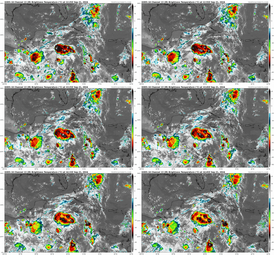
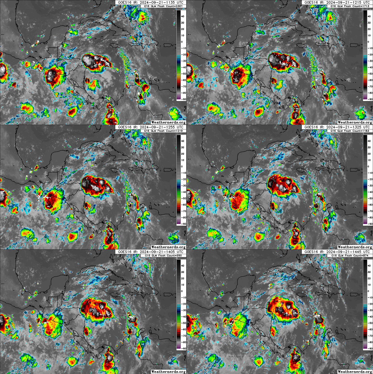
Convection has got quite concentrated this morning. Quite a bit of shear to the north or the disturbance. 06Z models are from Louisiana to Florida, some have strong hurricane. Going to have to wait until a center develops to get a better idea where this is going......MGC
0 likes   

TomballEd
Category 2
Category 2
Posts: 694
Age: 61
Joined: Wed Aug 16, 2023 4:52 pm
Location: Spring/Klein area, not Tomball

Re: Area of low pressure to develop over the western Caribbean sea (0/60)

#787 Postby TomballEd » Sat Sep 21, 2024 9:57 am

I'm just happy that we finally have a blob to watch where the system is forecast to form.

Image
3 likes   

User avatar
SFLcane
S2K Supporter
S2K Supporter
Posts: 10163
Age: 47
Joined: Sat Jun 05, 2010 1:44 pm
Location: Lake Worth Florida

Re: Area of low pressure to develop over the western Caribbean sea (0/60)

#788 Postby SFLcane » Sat Sep 21, 2024 9:59 am

1 likes   

User avatar
chaser1
S2K Supporter
S2K Supporter
Posts: 5464
Age: 64
Joined: Sat Oct 15, 2005 5:59 pm
Location: Longwood, Fl

Re: Area of low pressure to develop over the western Caribbean sea (0/60)

#789 Postby chaser1 » Sat Sep 21, 2024 10:05 am

DunedinDave wrote:Would be crazy if Horseshoe Beach gets their third hurricane in one year. I wouldn’t put it out of the realm of possibilities at all.


Now THAT'S one place that I defy anyone from being able to successfully video a major hurricane landfall event (and survive) :eek:
0 likes   
Andy D

(For official information, please refer to the NHC and NWS products.)

User avatar
SFLcane
S2K Supporter
S2K Supporter
Posts: 10163
Age: 47
Joined: Sat Jun 05, 2010 1:44 pm
Location: Lake Worth Florida

Re: Area of low pressure to develop over the western Caribbean sea (0/60)

#790 Postby SFLcane » Sat Sep 21, 2024 10:05 am

As andy mentions not sure this was captured by the models very well interesting satellite appearance this morning surely.

Image
1 likes   

DunedinDave
Tropical Storm
Tropical Storm
Posts: 227
Joined: Fri Aug 25, 2023 10:31 am

Re: Area of low pressure to develop over the western Caribbean sea (0/60)

#791 Postby DunedinDave » Sat Sep 21, 2024 10:07 am

Surprised the NHC hasn’t even put a yellow X here yet. It’s like they want to make sure that their statement of 0% chance of development through the next 72 hours isn’t steered wrong.
0 likes   

User avatar
HurricaneBelle
S2K Supporter
S2K Supporter
Posts: 1179
Joined: Sun Aug 27, 2006 6:12 pm
Location: Clearwater, FL

Re: Area of low pressure to develop over the western Caribbean sea (0/60)

#792 Postby HurricaneBelle » Sat Sep 21, 2024 10:13 am

Josh Morgerman tweeted this after Debby (and Idalia the year before). Based on model trends the Weather Gods don't appear to be listening to him.

 https://x.com/iCyclone/status/1820441484165845219

4 likes   

User avatar
Steve
S2K Supporter
S2K Supporter
Posts: 9621
Joined: Sat Apr 05, 2003 11:41 pm
Location: Not a state-caster

Re: Area of low pressure to develop over the western Caribbean sea (0/60)

#793 Postby Steve » Sat Sep 21, 2024 10:14 am

Nothing organized through 72 hours on the ICON yet. A brief 1008 low shows up about 10am Monday but peters out. A broader 1006 takes its place. On the EPAC side of the gyre, there is a 999mb system at 69 hours. So it shows the focusing there first.

https://www.tropicaltidbits.com/analysi ... 2112&fh=69
0 likes   

User avatar
chaser1
S2K Supporter
S2K Supporter
Posts: 5464
Age: 64
Joined: Sat Oct 15, 2005 5:59 pm
Location: Longwood, Fl

Re: Area of low pressure to develop over the western Caribbean sea (0/60)

#794 Postby chaser1 » Sat Sep 21, 2024 10:16 am

DunedinDave wrote:Surprised the NHC hasn’t even put a yellow X here yet. It’s like they want to make sure that their statement of 0% chance of development through the next 72 hours isn’t steered wrong.


That'll change if this level of convection can maintain itself. I could see a 20% "Lemon" by 8:00pm today if it does.
0 likes   
Andy D

(For official information, please refer to the NHC and NWS products.)

sphelps8681
Category 2
Category 2
Posts: 785
Joined: Thu Aug 16, 2007 5:37 pm
Location: Somewhere over the rainbow

Re: Area of low pressure to develop over the western Caribbean sea (0/60)

#795 Postby sphelps8681 » Sat Sep 21, 2024 10:23 am

I think I will come back when an eye forms. No knowledge is gained at this point with any different scenarios since it will be in the Gulf for me. Hope all you in Florida stay safe and no harm is done. To all on the Gulf Coast stay safe as well.
Last edited by sphelps8681 on Sat Sep 21, 2024 10:26 am, edited 1 time in total.
0 likes   

User avatar
chaser1
S2K Supporter
S2K Supporter
Posts: 5464
Age: 64
Joined: Sat Oct 15, 2005 5:59 pm
Location: Longwood, Fl

Re: Area of low pressure to develop over the western Caribbean sea (0/60)

#796 Postby chaser1 » Sat Sep 21, 2024 10:23 am

HurricaneBelle wrote:Josh Morgerman tweeted this after Debby (and Idalia the year before). Based on model trends the Weather Gods don't appear to be listening to him.

 https://x.com/iCyclone/status/1820441484165845219


"Josh, your wish is my command". Sopchoppy it is! :grrr:
3 likes   
Andy D

(For official information, please refer to the NHC and NWS products.)

User avatar
Jr0d
S2K Supporter
S2K Supporter
Posts: 1409
Joined: Tue Aug 27, 2019 10:52 am
Location: Cayo Hueso

Re: Area of low pressure to develop over the western Caribbean sea (0/60)

#797 Postby Jr0d » Sat Sep 21, 2024 10:31 am

As always, the future tracks is iffy until we have something to track. I expect the current thunderstorm activity off of Honduras to fizzle again.

What is really starting to concern me is the the CMC and GFS seem to agree that whatever develops will be a large system, with the circulation and bands over more than half of the GoM, which could make storm flooding a major issue for all of the Florida Gulf Coast.

Image

Image
2 likes   

User avatar
cycloneye
Admin
Admin
Posts: 145311
Age: 68
Joined: Thu Oct 10, 2002 10:54 am
Location: San Juan, Puerto Rico

Re: Area of low pressure to develop over the western Caribbean sea (0/60)

#798 Postby cycloneye » Sat Sep 21, 2024 10:36 am

Look what we have tentatively for monday:

POSSIBLE LOW-LEVEL INVEST MISSION
NEAR 17.5N 84.5W FOR 23/1800Z.
5 likes   
Visit the Caribbean-Central America Weather Thread where you can find at first post web cams,radars
and observations from Caribbean basin members Click Here

DunedinDave
Tropical Storm
Tropical Storm
Posts: 227
Joined: Fri Aug 25, 2023 10:31 am

Re: Area of low pressure to develop over the western Caribbean sea (0/60)

#799 Postby DunedinDave » Sat Sep 21, 2024 10:40 am

I know I speak for a lot of people in the Tampa Bay Area but the last thing we need is another Debby where we get a foot of rain from this thing. We had a 10 minute thunderstorm yesterday and my street flooded because of all the rain we’ve had this summer. We need a drying out period…like 3 months of it to get back to normal.
1 likes   

User avatar
MetroMike
Category 4
Category 4
Posts: 952
Joined: Sun Aug 29, 2004 8:13 pm
Location: Tampa Bay
Contact:

Re: Area of low pressure to develop over the western Caribbean sea (0/60)

#800 Postby MetroMike » Sat Sep 21, 2024 10:42 am

caneman wrote:
wzrgirl1 wrote:I am 90 miles east of Naples. This shouldn’t affect me much right?


Watch the video jlauderdale posted above. It doesn't seem likely.


The video is almost 24 hrs old, so need an update from him.
0 likes   


Return to “Talkin' Tropics”

Who is online

Users browsing this forum: cajungal, gib, KeysRedWine and 54 guests